


 English (pdf)
 Article in xml format
 Article references
 Send this article by e-mail
 Cited by SciELO
  Similars in
SciELO
Similars in
SciELO 
 Permalink
Published-Publicado: 31/1/2019In the northwest of the Central Valley of Costa Rica, most of the population depends on waters of the Barva, Los Angeles, Bambinos, Upper Colima, and Lower Colima aquifers. In addition, these resources are the main source of water for the development of commercial and industrial activities. In Costa Rica, the Central Valley is the region in which the largest number of registered wells is reported, as 60% of the national population and 85% of the industrial activity are located in this region (State of the Nation Program, 2005).
However, the presence of agricultural areas and the rapid urban and industrial growth experienced by this area in recent years have led to an increase in activities with the potential to generate low to high levels of pollutants. Such is the case of the cantons of Barva, San Rafael and Santa Bárbara (Madrigal-Solís et al., 2014) and other areas on the Barva aquifer (Ureña et al., 2006).
Depending on the depth of the water table and the type of materials that cover this aquifer in a given area, the Barva aquifer is vulnerable to low to high levels of pollution, as shown by an investigation in the northern zone of the aquifer (Gómez-Cruz et al., 2014). Therefore, chemical substances including pesticides, fertilizers, hydrocarbon derivatives, nitrates and metals, could leach through the soil and enter the groundwater (Foster et al., 2013, Foster et al., 2007).
In addition, about 70% of the population uses septic tanks as a sanitation system in the Central Valley (AyA / MINAE / MS, 2016), which represents a potentially contaminating load due to the leaching of substances such as nitrates when such treatment systems are not adequately maintained. In a monitoring program for nitrate concentrations in the Barva aquifer during the period 1988-2004, Reynolds-Vargas et al. (2006) found a significant increase in some sites that extract water from this aquifer, which demonstrates its vulnerability to contamination by substances from septic tanks and fertilizers, and these authors emphasized the importance of implementing surveillance programs for groundwater quality in terms of this and other pollution indicators. On the other hand, Madrigal-Solís et al. (2017) found an increase in nitrate concentrations in water of the Barva aquifer, from the highlands to lower elevations, in what could be an incipient process of contamination.
At present, it is widely recognized that empowerment in groundwater management processes should be a priority (Kulkarni et al., 2004), taking into account that these aquifers are necessary for the progress and prosperity of communities, supplying drinking water to households and water to the agricultural and industrial sectors. However, many communities do not have adequate tools to carry out the necessary protection actions, such as groundwater quality monitoring programs.
The implementation of an aquifer water quality monitoring program is an essential tool for proper management (Van den Brink et al., 2007; Baran and Gourcy, 2013) and is part of groundwater protection programs (Foster et al., 2002), whose purpose is to control the impacts of pollutant loads. In addition, a monitoring program represents an opportunity for citizen participation in an integrated water resource management approach (GWP, 2013). This surveillance can be understood as a technically standardized program of observations, measurements and analyses of selected physical, chemical and biological variables. The types of surveillance programs include: a) monitoring of drinking water quality in supply sources and b) defensive monitoring. In the first case, only water samples taken from sources of supply are analyzed, and therefore, according to Foster and Gomes (1989) and Tuinhof et al. (2006), no information is provided on the quality of groundwater in the aquifer, that is, about spatial patterns, or on whether there are patterns in concentrations of chemical substances over several years. On the other hand, defensive monitoring, as defined by the World Bank (Foster and Gomes 1989), is intended to monitor groundwater quality up a hydraulic gradient near supply sources, to provide timely notice of a pollution front before the water is distributed to the population.
The sub-basins of the Bermúdez, Ciruelas and Río Segundo rivers, on the Barva aquifer, are characterized by their high levels of urban, agricultural and industrial development. Despite the fact that most of their inhabitants are supplied with groundwater, the only systematic control that is carried out in some supply sources is the analysis of the presence of microbiological contaminants and some basic physicochemical parameters, which is consistent with the objectives of monitoring the quality of the drinking water supply, but not necessarily with those of defensive monitoring.
Given the importance of the aquifers of the Central Valley, the main objective of this research was to design a monitoring network to evaluate the physical and chemical quality of groundwater in the sub-basins of the Río Segundo, Ciruelas and Bermúdez rivers, taking into account land use, as well as motivating representatives of institutions, local governments, development associations, community aqueducts, and private companies to participate in its operation.
Reference framework
Factors such as climate change, population increase, and environmental degradation, as well as the results of scientific research, have clearly indicated the urgent need to implement integrated water resources management to guide countries towards sustainable development. In the Latin American and Caribbean Region (LAC), population growth and economic development exert strong pressure on these resources (Andrade-Pérez and Navarrete, 2004). Management of water resources at the local and national levels is therefore one of the essential basic actions needed to satisfy the basic needs of living organisms and to guarantee availability of water with acceptable levels of quantity and quality for present and future generations. In Costa Rica, the Government is responsible for overseeing the management of water as a public resource, but it must also seek to create opportunities for diverse social actors to participate and carry out concrete actions that guarantee sustainability of this resource (Castro et al., 2004).
Due to the importance of citizen participation in water resource management processes, the creation of a groundwater monitoring program not only constitutes a tool for basic protection of groundwater and the benefits that it provides, but also offers an opportunity for communities to actively participate in this process. The main objectives of a groundwater monitoring strategy (Foster et al., 2002) are to: a) provide data on the natural state and trends of the hydrogeological system for planning, management and decision-making purposes for the protection and conservation of groundwater at the local, regional and national levels; b) provide accurate and reliable data to help identify the existence of point and diffuse sources of pollution, and c) produce data to study spatial-temporal changes in water quality. The type and amount of data needed depends on the objectives of that network, the class of potential pollutants that are located in the basin, and available financing.
For the operation of a monitoring system, the World Bank recommends taking samples every three months or less from areas with high or extreme hydrogeological vulnerability to pollution (Foster et al., 2007), while in areas with low or medium vulnerability it recommends a lower sampling frequency - for example, every four or six months.
Study area
The study area is located in the northwest part of the Central Valley, in the upper sectors of the Virilla river basin (Figure 1), specifically between the geographic coordinates -84.24 and -84.06 west longitude, and 9.96 and 10.13 north latitude, according to the WGS84 coordinate system. Precipitation ranges from 830 mm/year at lower elevations, up to 1700 mm/year in the most rainy areas at higher elevations. It consists of the Bermúdez, Ciruelas and Río Segundo rivers sub-basins, located on the Barva Multi-aquifer System.
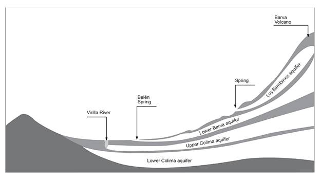
The Barva Multi-aquifer System, also known as the Barva aquifer, has an area of 189 km2 and consists of three formations that host sub-aquifers in fractured volcanic rocks (BGS / SENARA, 1985, Rodríguez, 2002, Ramírez and Alfaro, 2002): Bermúdez (the Lower Barva aquifer, the most extensive), Bambinos, and Los Ángeles (Upper Barva aquifers) (Figure 1). Each sub-aquifer is separated by tuffs and weathered pyroclasts. The Barva aquifer has a saturated thickness that ranges from approximately 4 to 66 m. The Bermúdez Formation is underlain by the Tiribí Formation, which is the base of the Barva aquifer in the central and western sectors, and the Zurquí Complex, which is the base of the Barva aquifer in the eastern sector. The upper and lower Colima aquifers are located under these formations (Figure 2). The upper areas of the Bambinos and Los Angeles sub-aquifers are recharged by direct infiltration of precipitation. The Lower Barva sub-aquifer in these sectors is recharged by drainage from these two sub-aquifers through tuffaceous material. In the rest of the territory, the aquifer is recharged by direct infiltration. It is estimated that recharge of the Barva Multi-aquifer System varies between 30 and 55% of precipitation, depending on permeability, the hydraulic conductivity of the tuffs, and the amount of rain in each sector of the aquifer (Gómez, 1987; Reynolds-Vargas, 1997; Ramos, 2001). The sub-basin of the Bermúdez river has an area of 73.72 km2, the sub-basin of the Ciruelas river has an approximate area of 90.41 km2, while the sub-basin of the Río Segundo has an area of 85.58 km2.
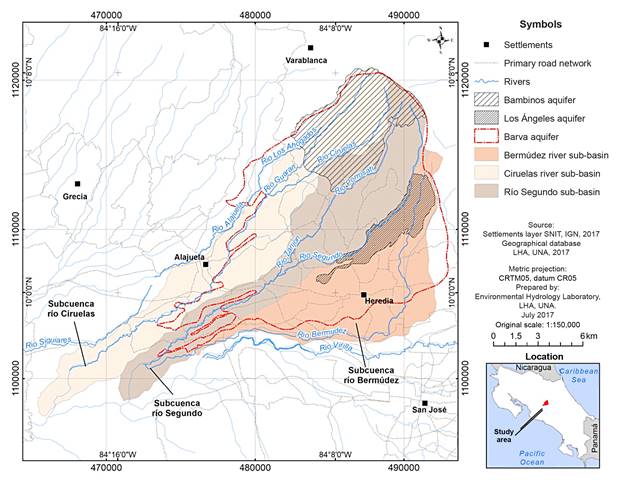
Figure 1 Study area for the design of groundwater quality monitoring networks for the Barva and Colima aquifers. Prepared by the authors.
Methodology
Land use
Land use in 2005 was taken as a reference, which was created and verified in the field in 2008 by the Regional and Urban Planning Program of the Greater Metropolitan Area (whose acronym in Spanish is GAM) (PRUGAM, 2008). Specifically, the land use map for the GAM was used; this map was included in the Environmental Fragility Indexes (IFAs), according to the classification criteria of the PRUGAM, which consists of 21 categories. These were reclassified into five coverages: forest, pastures, mixed crops, coffee, and human settlements.
Monitoring networks
Three networks were designed to monitor the physicochemical quality of groundwater in the Bermudez, Ciruelas and Río Segundo sub-basins. To do so, drilling reports were obtained from the wells registered in the Water Department of the Ministry of Environment and Energy, and in the National Groundwater, Irrigation and Drainage Service (SENARA). In each sub-basin, lithological information was obtained from at least 200 wells. Of these, the aquifer from which water was obtained was identified based on the lithological record, hydrogeological profiles and well design. In addition, the Hydrogeological Map of the Central Valley of Costa Rica (BGS / SENARA, 1985), and the geological description of the area according to BGS / SENARA (1988) were used. Aquifers in at least 45 wells in each sub-basin were identified. After identifying which wells draw water only from the Barva aquifer and which draw water from the Upper and Lower Colima aquifers, a search for these wells was carried out in the field. At least 25 wells were located and sampled, while no samples were obtained from the other wells, as they were abandoned or it was not possible to obtain permission to take samples from them.
In each basin, two pre-sampling campaigns were carried out in wells and springs to obtain basic physical and chemical information about the water. A final selection was made from all the sampled sites, based on the following criteria: a) clear definition of the aquifer unit from which water was being captured (Barva or Colima), b) water was obtained from only one aquifer per site, c) spatial distribution of the sites in each sub-basin, taking into account the preferential groundwater flow paths, c) ease of access to the sites and, d) preliminary physical and chemical results. Once the sites for the monitoring network were selected in each sub-basin, two additional sampling campaigns were carried out, for a total of four campaigns per sub-basin. The four campaigns were carried out in the sub-basin of the Bermúdez River in December of 2006 and February, April and September of 2007; in the sub-basin of Segundo river in May, August, September and November of 2009; and in the sub-basin of the Río Segundo Rn December of 2010 and June, August and October of 2011.
Each monitoring network was presented to community organizations, local governments and water resource management organizations, in at least three participatory workshops in each sub-basin. During these workshops, talks were given on problems facing the quality of groundwater in the Central Valley, basic principles related to groundwater monitoring networks, and the importance of systematic and permanent operation of a network in the Barva and Colimas aquifers. In addition, a work plan was prepared and an analysis of strengths, weaknesses, opportunities, and threats (SWOT) was carried out. A monitoring commission of six persons was established for each sub-basin, which were provided with training in the operation of the monitoring network through their participation in several sampling campaigns and a manual on the methodology for each network.
Finally, the three networks were integrated in a single permanent network for the Barva aquifer and some Colima sites, in a participatory workshop with representatives of ASADAS and members of the monitoring commissions of the three sub-basins.
Sampling and physical and chemical analyses
Before taking the samples from the wells, it was verified that they were pumping water at least during the last two hours before sampling. If a well was not in operation, the pump was turned on and the water was drawn for 20 minutes before taking the samples. To verify that stagnant water in the well and pipes had been purged, field parameters were measured several times until the values stabilized. For each water sample, electrical conductivity was determined in situ, using a WTW LF 197 field conductivity meter, and temperature and pH were determined using a Thermo Orion 261S meter. Duplicate samples were taken in 500 ml Nalgene bottles, which were rinsed with water from the site three times before collecting the samples. Then, they were transported the same day, in a cooler, to the Laboratory of Environmental Hydrology of the Universidad Nacional, where they were kept under refrigeration at 4 °C, until their analysis the following day. The nitrate analyses were carried out using ultraviolet light spectrophotometry (protocol 4500 NO3-B, Eaton, Clesceri, Greenberg and Franson, 1995). Bicarbonates were determined by titration with sulfuric acid (method 2320-B), chlorides with the mercury nitrate methodology (4500 - Cl- - C), and sulfates with the 4500-SO4-2-E methodology (Eaton et al., 1995).
Results
In 2008, the land use on the Barva aquifer dedicated to forests and pastures corresponded to 24% and 15% of the total area, respectively, primarily between 1400 and 2800 meters above sea level. In the middle areas of the sub-basins, from 1000 to 1400 meters above sea level, coffee and other agricultural crops predominate, covering 26% and 12% of the area above the aquifer, respectively. Urban and industrial development covered 23% of the area, mainly in the lower parts of the aquifer, from 800 to 1000 meters above sea level (Figure 3).
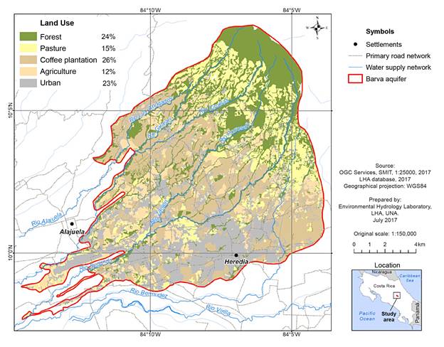
Figure 3 Land use on the Barva aquifer in 2005, with field verification in 2008. Prepared based on the Regional and Urban Planning Program of the GAM (PRUGAM, 2008).
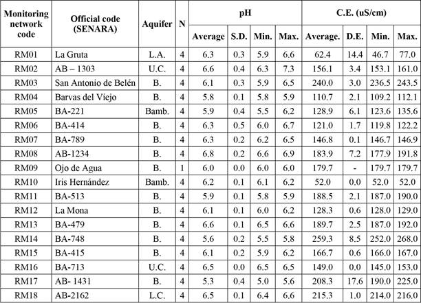
The network designed for monitoring water quality of the Barva Multi-aquifer System in the sub-basins studied consisted of 15 sites: one that captures water from the Los Ángeles aquifer, two that capture water from the Bambinos aquifer and 12 that extract water from the Lower Barva aquifer. In addition, the proposed program includes the monitoring of two sites that extract water exclusively from the Upper Colima aquifer and one from the Lower Colima aquifer (Table 1 and Figure 4). Only these three sites met the requirement of extracting water exclusively from these aquifers, preventing the intake of groundwater mixed with water from the Barva aquifer.
Table 1 Network for monitoring the physical and chemical quality of groundwater in the sub-basins of the Bermúdez, Ciruelas and Segundo rivers, Costa Rica
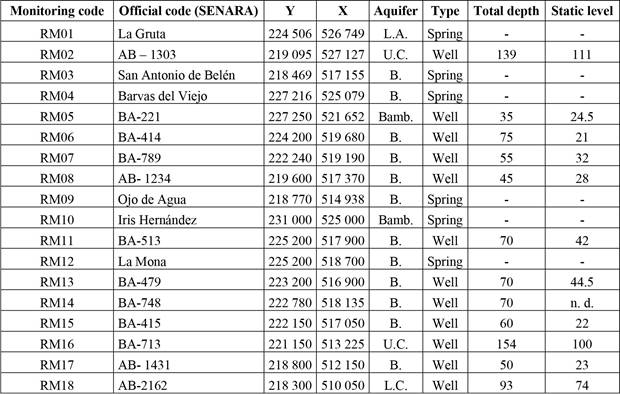
Note: L.A. = Los Ángeles; Bamb. = Bambinos; B.= Barva; U.C.= Upper Colima; L.C. =Lower Colima.
Source: Prepared by the authors.
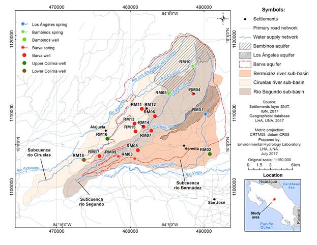
Figure 4 Locations of the wells and springs that make up the physical and chemical quality monitoring network for groundwater of the Barva and Colima aquifers in the sub-basins of the Bermúdez, Ciruelas and Segundo rivers, Costa Rica. Prepared by the authors.
During the sampling campaigns, the values of pH and electrical conductivity, as well as the concentrations of chlorides, bicarbonates, and sulfates, conformed to the national standards specified in the Regulation for Drinking Water Quality in Costa Rica 38924-S (Tables 2 and 3).
In the case of nitrates in sites that extract water from the Barva Aquifer System, located in the Bermúdez river sub-basin, concentrations ranged between 0.04 mg/l in the La Gruta spring, Los Angeles sub-aquifer, and 34, 09 mg/l in the Belén spring, Lower Barva sub-aquifer. In the Segundo River sub-basin, nitrates concentrations between 0.49 mg/l were observed from the Bambinos sub-aquifer, and 26.16 mg/l at the RM08 site in the canton of Belén, Lower Barva sub-aquifer. Likewise, in the sub-basin of the Ciruelas River, nitrate concentrations ranged between 0.22 mg/l, in the Iris Hernández spring of the Bambinos sub-aquifer, and 42.19 mg/l in the RM14 well, which extracts water from the Lower Barva sub-aquifer (Table 3).
Table 2 Averages, standard deviations, and minimum and maximum physical parameters in the three networks for monitoring groundwater quality in the sub-basins of the Bermúdez, Ciruelas and Segundo rivers, Costa Rica
Note: L.A. = Los Angeles; Bamb = Bambinos; B. = Barva; U.C. = Upper Colima; L.C. = Lower Colima.
Source: Prepared by the authors.
Of the 15 sites that extracted water from the Barva Aquifer System, five exceeded, on two to four occasions, the alert value (AV) of 25 mg / l, which is defined as the concentration at which there is a minimum or acceptable health risk for consumers, according to the Regulation for Drinking Water Quality in Costa Rica 38924-S (Table 3). All of these sites were located in areas in which urban use and coffee crops predominated. However, during the sampling campaigns conducted for this study, no site exceeded the maximum admissible values (MAV) of 50 mg / l nitrate (NO3 -). It was also found that the sites with the lowest concentrations were found in the upper areas of sub-basins, where forest and pastures predominate.
Of the three sites that collected water from the upper and lower Colima aquifers, none exceeded the AV or the MAV in terms of nitrates at any time.
Table 3 Averages, standard deviations, and minimum and maximum chemical parameters in the three networks for monitoring groundwater quality in the sub-basins of the Bermúdez, Ciruelas and Segundo rivers, Costa Rica
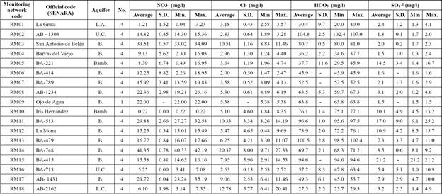
Note: L.A. = Los Angeles; Bamb = Bambinos; B. = Barva; U.C. = Upper Colima; L.C. = Lower Colima.
Source: Prepared by the authors.
Participatory workshops
The conformation of the three monitoring networks, as well as the physical and chemical results of the monitoring campaigns, were made known through at least three participatory workshops per sub-basin, attended by representatives of the following organizations: Rural Aqueduct Administrators Associations (whose acronym in Spanish is ASADAS), the Federation of Municipalities, environmental community organizations, local governments, the Ministry of Health, the Public Services Company of Heredia (ESPH), development associations, SENARA, and the Costa Rican Institute of Aqueducts and Sewers (AyA).
During these workshops, a six-person monitoring commission was created for each sub-basin. In the case of the Ciruelas sub-basin, this commission was formed by representatives of the following entities: the Municipality of Alajuela, the Municipality of Santa Bárbara, the Committee for Surveillance of Natural Resources (COVIRENA) of Desamparados de Alajuela, the ASADA of Carrizal, the Interdisciplinary Program of Research and Water Management of the Universidad Nacional (PRIGA-UNA) and SENARA. In the case of the Río Segundo River sub-basin, this commission was made up of representatives of ASADAS, community development associations, the Ministry of Health and the Municipality of Barva. In the Bermudez sub-basin, this commission was formed with representatives of the Public Services Company of Heredia (ESPH), which provides drinking water service in a large part of the area under study, as well as representatives of the municipalities of Heredia, Santo Domingo, San Rafael de Heredia, Flores, San Rafael de Alajuela, Belén and San Pablo. In order to train members of these commissions in the location of sampling sites and protocols, these members participated in the last two sampling campaigns in each sub-basin.
Subsequently, a participatory workshop was held to discuss the guidelines for joint work between representatives of community aqueducts, municipalities, SENARA and the Universidad Nacional, with participation of representatives of the monitoring commissions of each sub-basin, and of 31 representatives of community aqueducts and the Federation of Municipalities of Heredia and Alajuela. Carrying out seminar-workshops and meetings with members of each commission allowed them to understand the advantages and disadvantages of achieving the objectives of the proposed program through a SWOT analysis carried out in conjunction with representatives of the municipalities and organizations that attended these meetings.
When considering strengths, it was found that there is a concern for groundwater quality monitoring by local government authorities, the SENARA, the Ministry of Health, the Federation of Municipalities, and community aqueducts. This facilitated the creation of an interdisciplinary commission for each sub-basin, to launch and provide continuity for the monitoring network. In addition, support or follow-up was provided by the Universidad Nacional, which has the experience and baseline information needed to support the proposed activities and data interpretation. This activity would also involve active participation of civil society in the protection of water resources.
Implementation of these monitoring networks also offers several opportunities. The information generated and interpreted would serve as a scientific basis for decision making in the formulation and implementation of policies for groundwater protection. Participants would receive training in the application of methodologies for the operation of a monitoring network. Information on the activities and needs related to the monitoring network would be disseminated through the different municipal councils. Finally, there is an opportunity to link entities such as the AyA, ESPH, ASADAS, ICE, MAG, MINAET, the Ministry of Health, SENARA and the COVIRENAS through the proposed program activities.
However, some weaknesses were also identified. The main problem that the network operation would face is the lack of funding for the basic physicochemical analyses and other complementary analyses of the samples. In addition, engagement and commitment of the different entities and participants in these activities is not obligatory. Likewise, among the threats to the implementation of a monitoring program, the lack of continuity of authorities in local governments was identified, which hinders their commitment and long-term financial collaboration with the program objectives.
Discussion
Monitoring networks are one of the most important methods for establishing strategies and policies for the protection and conservation of water resources; implementation of monitoring programs helps improve groundwater management and allows both anticipating and controlling pollution processes. In addition, implementation of the proposed monitoring networks offers an excellent opportunity for social participation in processes to monitor the physical and chemical quality of groundwater in a systematic and permanent manner, and even provides a space for raising awareness about the importance of actions on the part of inhabitants and users that contribute to rational and sustainable management of groundwater in the zone.
The fact that the sites with the lowest concentrations of nitrates were located in the upper areas of the sub-basins studied, which are dominated by forest and pastures, while the sites with the highest concentrations were located in middle and lower zones, where urban use and coffee cultivation predominate, is consistent with what was observed by Reynolds-Vargas et al. (2006) and Madrigal-Solís et al. (2017). This confirms the suspicion that nitrates originate from leaching from septic tanks, which are very frequently used in urban and semi-urban areas, and from agricultural areas where nitrogen fertilizers are applied. The water from the Colima aquifer, meanwhile, had low concentrations of nitrates and chlorides, which is attributed to the fact that most of its extent is protected by the overlying Barva aquifer, although there is evidence of some hydraulic connection between these aquifers (Madrigal-Solís et al., 2017). Because the wells that capture water from the Colima aquifers, depending on their location, also go through the Los Ángeles, Bambinos and / or Lower Barva aquifers, builders set up grids to take advantage of water from these levels as well. Therefore, most wells in the area that capture water from the Colima aquifers also extract water from other aquifers, making it difficult to establish a monitoring network specifically designed for the Colima aquifers.
In the case of the Barva aquifer and sites that capture water from the Colima aquifers, a sampling frequency of at least once every four months is recommended - that is, once in the dry season, once in the rainy season, and again in the transition period. Among the basic group of parameters to be measured are nitrates and chlorides, pH, electrical conductivity and temperature. Occasionally, when there is a suspicion of any source of groundwater contamination, it is recommended to carry out analyses of heavy metals, pesticide residues, hydrocarbon derivatives and volatile organic compounds as well. These analyses make up the group of complementary parameters.
When adequate technical information is available, monitoring the quality of groundwater is a tool that can be implemented by institutions, civil associations, the private sector, or water managers at the basin or aquifer levels. Likewise, validation provided by the participants of local governments, water management bodies and local community actors is fundamental in the integration of water resources management and participatory management. This integration would promote support among stakeholders in the basin to encourage implementation of monitoring, and the consequent generation of technical information for decision making and supervision policies.
The success of a monitoring network depends on active participation of stakeholders within its territory. It is known that there may be many constraints on achieving the desired results, mainly those that have to do with the management of data and the continuity of sampling over time as a result of budgetary limitations. However, if there is a common commitment among local and national water resources management bodies, the outlook is mostly positive. The results of exercises carried out in the workshops and training show a collective interest in interventions to improve water quality; taking advantage of this interest, accompanied by political endorsement by municipalities and the national government, would provide an ideal platform to generate important advances in this area.
One of the biggest obstacles to the functioning of monitoring networks is obtaining financing, and ensuring continuity of systematic monitoring. It is therefore recommended that support be sought from local governments, private companies, and public institutions such as SENARA or ESPH, through alliances or agreements. If sampling and analysis are carried out, it is recommended that the committees seek the support of a professional in the field to interpret this information, since not only must the physical and chemical parameters in the water be kept below the admissible values for human consumption, but it is also essential to interpret physical and chemical information in a comprehensive manner to determine if there are temporal and spatial patterns in the aquifer.
There are weaknesses in the legislation for protecting and controlling surface water and groundwater with respect to the implementation of networks for monitoring the quality of these waters, despite the fact that such monitoring is a vital tool in the generation of information for decision making and the definition of protective strategies for groundwater at the local, regional and national levels.
Due to the lack of planning that has accompanied the change in land use in this area, water management at the institutional and municipal levels has become increasingly complex. It is therefore vital to integrate citizen participation into the management of monitoring networks and other measures for the protection and management of groundwater, to compensate for the human and economic limitations experienced by state governing institutions.

