


 Spanish (pdf)
 Article in xml format
 Article references
 Send this article by e-mail
 Cited by SciELO
  Similars in
SciELO
Similars in
SciELO 
 Permalink
Introducción
Coasts are classified in various ways, such as rocky and sandy. On rocky coasts, changes are slow, while on sandy coasts or beaches changes are constant, which is why they are classified as highly dynamic and complex ecosystems. They are affected by factors such as the quantity and intensity of waves, the type and size of sediment and the amplitude of tides, which give rise to a variety of beaches with different physical and topographic characteristics (1). Additionally, human activities that take place on these beaches also determine part of their dynamics. The erosion processes are related to the development of physical infrastructure, and the processes of deposition and erosion of sand on the beach are determined by these factors (2).
In Costa Rica, the Caribbean coast is relatively short (212 km long) and straight. The southern section contains sandy beaches, made up of terrigenous sediments and marine carbonates, interrupted by rocky headlands which consist mainly of fossil coral reefs (3).Three marine ecological units occur in this region - Estrella, Cahuita and Sixaola. Estrella is a coastal plain with high-energy barrier beaches; Cahuita has rocky cliffs and high-energy pocket beaches; and Sixaola is a coastal plain with exposed black sand beaches (4).
Likewise, human uses of coastal areas of the Southern Caribbean of Costa Rica are diverse, including recreation, basic sanitation, and growing industrial and port activity. It is one of the main tourist destinations in the country, due to its landscapes and the natural beauty of its beaches and reefs (5).
In general, these beaches are ecologically relevant, since they are the sites of various processes such as filtration and purification of water, storage and transport of sediments, mineralization and recycling of nutrients. They are also nesting sites for turtles and birds, favor the decomposition of organic materials and pollutants, and allow functional links between terrestrial and marinecoastal environments (6, 7, 8).
On the other hand, these coastal areas favor the concentration of human populations, due to the facilities they provide for the development of activities including fishing, industry, tourism, and transportation. This has led to the beaches being exposed to a wide range of stressors generated by anthropogenic threats, both at a local and a global level, such as trampling, pollution, coastal development and rising sea levels (9).
Due to the effects of climate change, these beaches are experiencing rapid variations which increase their vulnerability to floods, tsunamis, storms and extreme tides. This generates important economic, social and ecological impacts (10). Despite the services they offer and their increasing vulnerability, these Caribbean coastal areas have not been studied frequently, partly because marine coastal research in the country has historically been concentrated on the Pacific coast, which has led to information gaps. Therefore, the present study is intended to characterize the beaches of the southern Caribbean of Costa Rica as a baseline for marine coastal management.
Materials and methods
Study area
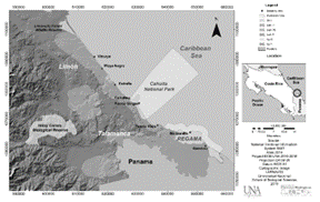
In terms of the country’s administrative divisions, the Southern Caribbean of Costa Rica (SC-CR) is located in the cantons of Talamanca and Limón in the province of Limón. For the purposes of this investigation, it extends from the Central Canton of the province of Limón to the Sixaola river, on the border with the Republic of Panama. It is part of the La Amistad Caribe Conservation Area (ACLAC) of the National System of Conservation Areas (SINAC), which is controlled by the Ministry of Environment and Energy (MINAE). Work was carried out on eight beaches, which are described below:
Vizcaya (09° 54’ 08.5'' N and 82° 58’ 44.7'' W): A black sandy beach with an approximate length of 7 km, lying between the mouth of the Banano river and the mouth of the Bananito river. It has no coral systems and is influenced by the Banano River. It is surrounded by an agricultural landscape, mainly of musaceae, and has a low population density. There is little infrastructure on this beach, which is limited to small houses. Vegetation cover is scarce and is dominated by herbaceous plants (Figure 1).
Negra (09° 50’ 50.8'' N and 82° 56’ 10.4'' W): A black sandy beach with an approximate length of 7 km, lying between the mouth of the Banano river and the Vizcaya estuary. It has no coral systems. It is surrounded by an agricultural landscape, mainly of musaceae, and has a low population density. There is little infrastructure on this beach, but it includes small houses and lodge-type hotels. In the southern part of the beach, the sparse vegetation cover is dominated by herbaceous plants, and in the north there are flooded forests with raffia palms (Raphia taedigera) (figure 1).
Estrella (9° 47’ 48.8'' N and 82° 53’ 39.8'' W): A gray sandy beach with an approximate length of 5 km, lying between the mouth of the Vizcaya estuary and the Estrella river. It does not have coral systems. It is surrounded by an agricultural landscape mainly of musaceae and has a low population density. There is little infrastructure on this beach, limited to small houses. Vegetation cover is scarce, and is dominated by herbaceous plants (figure 1).
Residential houses and informal buildings located scattered within the maritime-land zone (200 m inland measured from the tide line) dominate the three beaches. Cultivated or natural Coconut (Cocos Nucifera) is abundant on these beaches and is used by local inhabitants. These beaches are not included within any management category. Ecosystems include secondary forests, raffia palm swamps, lagoons and herbaceous swamps, rivers, and estuaries (figure 1).
Cahuita (9° 44’ 41.8'' N and 82° 51’ 13.8'' W): Primarily a white sand beach, but includes rocky sectors and the presence of small patches of reef. It has an approximate length of 5 km, and lies between the mouth of the Tuba river and the entrance to the Cahuita National Park. It is an important tourist attraction, located in a moderately populated area with houses, hotels, restaurants, and is not included in any management category. Coconut and Beach almond (Terminalia catappa) dominate the coastal vegetation (figure 1).
Puerto Vargas (9° 42’ 46.4'' N and 82° 48’ 45.2'' W): A white sand beach with shell fragments, located within the Cahuita National Park. It has an approximate length of 7.5 km between Puerto Vargas and the Carbón river, and contains the most important coral reef patches and sea grasses in the Caribbean. On land, there are wetlands such as lagoons, mangroves and flooded forests. It is an important tourist attraction, but due to its management category, it can only be visited during the daytime. Infrastructure is scarce, but in the 1970s, a small port was established which is currently abandoned (figure 1).
Puerto Viejo (09° 39’ 18.1'' N and 82° 45’ 23.4'' W): It is a black sandy beach, with patches of reef and sea grass, which has a length of approximately 5 km from the mouth of the Carbón river to the entrance to the town of Puerto Viejo. It is an important tourist attraction, in a more populated area with houses, hotels, and restaurants. It is not included in any management category. The mainland has raffia palm swamps and flooded forests, lagoons, rivers, and estuaries (figure 1).
Manzanillo (9° 38’ 07.2'' N and 82° 39’ 12.3'' W): A grayish sandy beach with patches of reef and marine phanerogams. On the mainland there are areas of forest and coastal wetland, mainly raffia palm swamps. It has a length of approximately 5 km between Punta Uva and Punta Manzanillo, and is an important tourist attraction within the Gandoca-Manzanillo National Wildlife Refuge, with infrastructure that includes houses and small hotels (figure 1).
Gandoca (9° 34’ 38.8'' N and 82° 34’ 30.9'' W): A black sandy beach located in the sparsely populated locality of the same name, with a length of 12 km between Punta Mona and the Sixaola river. There are some reefs at Punta Mona, but they are infrequent. On the mainland, forests, flooded forests, raffia palm swamps, lagoons and mangroves dominate. It is a nesting area for sea turtles, and is located within the Gandoca-Manzanillo National Wildlife Refuge (figure 1).
The SC-CR region is characterized as belonging to the Tropical Humid Forest (bh-T) life zone. It has two rainy seasons, the first from November to March and the second from June to August with rainfall of 4500 mm/year and high relative humidity; there is less rainfall at other times of the year, but there are no truly dry months. The tides are mixed; they are mainly diurnal and range from 30 to 50 cm. Waves come from the northeast between January and June and from the east between July and December, depending on the position of the Inter-Tropical Convergence Zone. Currents flow from northwest to southeast with small cyclonic eddies that transport terrestrial sediments from deforested riverine and coastal areas (11)
Methods
Definition of transects and sampling points
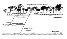
Transects 100 m long were systematically defined from the beginning to the end of each beach in a north-south direction, separated from each other by a distance of approximately 1 km. The number of transects on each beach (between 5 and 6) depended on the length of the beach. Transects were located parallel to the coast, in the first vegetation line located immediately after the dunes. Each transect contained 11 sampling points, separated from each other by a distance of 10 m (figure 2). Latitude and Longitude were recorded with a GPS receiver in geographic coordinates (WGS84, CRTM05).
Characterization of beaches
Measurements of beach width were made at all sampling points, and width and height were measured at points where erosive scarps existed. The variables recorded were the following: 1) Beach width: Distance from the line of vegetation after the dunes to the tide line (recorded in m). 2) Scarp width: Width of the vertical step formed on the beach due to coastal erosion. Measured at the point of origin, from the dunes towards the tide line (recorded in m). 3) Scarp height: Height of the vertical step formed on the beach due to coastal erosion (recorded in cm) (figure 2).
Granulometry of the dune sands
A sand sample was collected at a depth of 5 cm at each sampling point on the dunes. These samples were transferred to the Laboratory of Natural Resources and Wildlife of the Universidad Nacional, where they were dried for three days in an oven at 40 degrees Celsius. Once dried, the samples were sifted using overlapping sieves with the following mesh opening sizes: 1: 2000 µm, 2: 850 µm, 3: 425 µm, 4: 250 µm and 5: 220 µm.
Post-dune arboreal vegetation
At the sampling points where there was arboreal vegetation after the dunes, individual trees were counted, identified at the species level and their heights were measured. Likewise, at all points regardless of the presence or absence of arboreal vegetation, the percentage of cover was measured. The variables measured are described below: 1) Arboreal vegetation: Trees in the first line of vegetation, located immediately after the dune. Specialized flora guides were used for the identification (12, 13). 2) Vegetation height: Height of the individuals of the tree species immediately after the dune (recorded in m); 3) Vegetation cover: Percentage of vegetation cover, measured immediately after the dune, at four cardinal points (North, South, East, West), using a Forestry Suppliers Model A spherical densitometer (figure 2).
Data analysis
An analysis of variance (ANOVA) was performed to determine the difference in variance in beach width, and a Tukey HSD test was used to compare data from different beaches. A frequency analysis was applied to data on the species composition at different sites, and a chi-square test was used to observe relationships between the beaches and the composition of species at each site. A non-parametric correlation test (Spearman’s rho) was applied to determine the relationship between the width of beaches and the width and height of beach scarps. The software programs used were PSPP ©, R Commander ©, SPSS © and Excel © (14, 15, 16, 17).
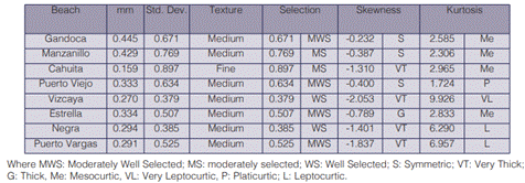
The granulometric analysis of sand dunes was based on the average sample, which included all sampling points of every beach during the study period. The average particle diameter (M) was obtained in millimeters (mm) and Phi (Φ); standard deviation, degrees of freedom, skewness and kurtosis were obtained using the method of moments, and computed using Gradistat Version 8.0 software (18). For sediment classification, the Wentworth scale was used (19, 20).
Results
During 2013, a total of 47 transects and 517 sampling points were established in the eight beaches.
Beach width
The site with the smallest beach width was Cahuita (4.8 m), while the one with the widest beach was Vizcaya (104.7 m). The beaches with the smallest average widths were Manzanillo and Gandoca, while Puerto Viejo and Vizcaya had the largest average widths. The Figureures for Cahuita and Vizcaya showed high variances that could indicate intragroup variations. There are significant differences between the widths of the eight beaches studied (ANOVA, p<0.05).
These differences are found between three subgroups of beaches, which include Manzanillo and Gandoca, Estrella, Puerto Vargas, Cahuita and Negra, and lastly, Puerto Viejo and Vizcaya (Tukey HSD, p<0.05) (figure 3) .
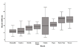
Figure 3 Box diagram of beach widths (m) on southern Caribbean beaches in Costa Rica, 2013. Lines in bold indicate medians, box diagrams indicate the 25th to 75th percentiles, and whiskers show minimum and maximum values.
Scarp width and Height
A total of 129 scarps were identified, representing 25.24% of the points sampled with signs of erosion. The widths of the scarps varied from 3.90 m to 43.70 m. Gandoca and Manzanillo had the smallest average scarp widths, followed by Estrella, Negra, Puerto Viejo and Puerto Vargas (Figure 4A). Finally, Vizcaya and Cahuita had the greatest average scarp widths (39 m and 34 m, respectively). There was a high positive correlation between beach width and scarp width (Spearman’s rho = 0.705; P <0.05).
The heights of scarps varied between 15 cm and 70 cm. Playa Negra had the lowest average value for this variable, while Gandoca had the highest (Figure 4B). A low negative correlation was evident between the width of the scarp and the height of the scarp (Spearman’s rho = 0.14; P> 0.05).
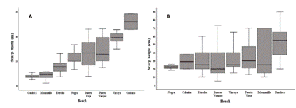
Figure 4 A) Box diagram of scarp widths (m), B) Box diagram of scarp height (cm). In southern Caribbean beaches in Costa Rica, 2013. Lines in bold indicate medians, box diagrams indicate the 25th to 75th percentiles, and whiskers show minimum and maximum values.
Dune sand granulometry
Eighty-seven point five per cent (87.5%) of the beaches had medium-sized dune sand and the other had fine dune sand. Gandoca and Cahuita had the highest mean particle diameter (M), 0.445 mm and 0.429 mm respectively, and Vizcaya had the smallest (0.270 mm). The only site that had fine sand was Cahuita, with an M of 0.159 mm (table 1).
In 50% of the beaches, the degree of selection was classified as moderately well selected, 25% well selected and 25% moderately well selected. All the beaches had negative skewness values: 50% of the beaches had very coarse skewness, 37.5% were symmetrical and 12.5% were coarse. Regarding kurtosis, 50% of the beaches were categorized as mesocurtic, 25% leptocurtic, 12.5% very leptocurtic, and 12.5% platicurtic (table 1)
Post-dune arboreal vegetation
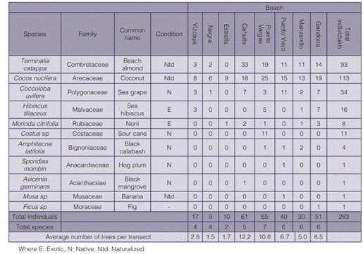
No post-dune arboreal vegetation was found in 44.81% of the sampling sites, one tree species was found in 47.16% of the sites, and two species were found in 7.64% of the sites. A total of 283 trees or shrubs of 11 species and 11 families were recorded. The largest numbers of trees and species were found in Puerto Vargas, Manzanillo, Cahuita, Gandoca and Puerto Viejo, four of which are located within Protected Wild Areas, while Vizcaya, Estrella and Negra, which are not located within protected areas, had the least numbers of trees and species (table 2).
The species that presented the highest frequency of occurrence were: Cocos nucifera (Coconut), Terminalia catappa (Beach almond) and Coccoloba uvifera (Sea grape), while those that were less frequently observed were Avicennia germinans (Black mangrove, a threatened species), Spondias mombin (Hog plum), and Ficus sp (Table 2). Of the identified species 45.5% were native, 27.3% naturalized and 18.2% exotic. For example, the Coconut is naturalized; in some beaches it is cultivated and in others it grows naturally. The frequency analysis shows a significant relationship between the sites and the composition of plant species associated with each one (Chi-square = 126.95 p <0.05).
The highest average of trees per transect was found in Cahuita, Puerto Vargas and Gandoca, while Playa Estrella and Negra reported the lowest values. It should be emphasized that vegetation was evaluated in the coastal vegetation line.
Table 2 Absolute frequency of plant species recorded in dunes of southern Caribbean beaches in Costa Rica during 2013.
Vegetation coverage
Vegetation coverage in Gandoca, Puerto Vargas and Cahuita was greater than 80%. The first two beaches are located within Protected Wild Areas, under two different management categories, Gandoca within a mixed-type Wildlife Refuge and Puerto Vargas within a National Park. In Playa Negra and Estrella, vegetation cover was less than 20%. In the case of Vizcaya, there was a great deal of variability in vegetation cover in the sampled sites (Figure 5). In Puerto Viejo, vegetation cover was high and highly variable with different levels of coverage by sectors. In the transects located to the Northwest of the town, there is more forest, dominated by Beach almond, Sea Hibiscus, and tall Sea grapes, while in the transects nearer to the town, where tourist activity and infrastructure dominate, coverage is scarce, and medium-sized coconuts and areas without vegetation dominate.
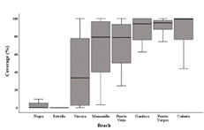
Figure 5 Box diagram of average vegetation cover (%) in southern Caribbean beaches in Costa Rica, 2013. Lines in bold indicate medians, box diagrams indicate the 25th to 75th percentiles, and whiskers show minimum and maximum values.
Vegetation height
Vegetation heights ranging from 0.5 m to 27 m were recorded on the beaches, with an average of 8.40 m. The greatest heights were registered in the Manzanillo, Puerto Vargas, Cahuita and Vizcaya beaches; the first two are located in Protected Wild Areas, and the second two are in areas with low urban development. In some beaches, such as Puerto Vargas and Gandoca, the vegetation is of natural growth and is typical of the coastline, while in other areas such as Vizcaya and Puerto Viejo, which are tourist attractions or sites of coconut harvesting, there is cultivated vegetation as well as natural growth.
Vegetation height was lower in the Gandoca, Puerto Viejo, Estrella and Negra beaches (Figure 6). Vizcaya, Estrella and Negra had the least variability in vegetation height and the smallest number of species, influenced by the elimination of undergrowth or secondary growth carried out to facilitate entry to sites, and fruit harvesting of species of commercial interest such as Coconut and Beach almonds.
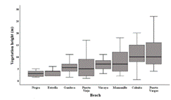
Figure 6 Box diagram of the height of vegetation on southern Caribbean beaches in Costa Rica, 2013. Lines in bold indicate medians, box diagrams indicate the 25th to 75th percentiles, and whiskers show minimum and maximum values.
Discussion and conclusions
Coasts are dynamic environments exposed to erosion processes, deposition and transport mechanisms. In the case of the southern Caribbean in Costa Rica, the width of sandy beaches does not remain constant, due to factors such as the time of year (dry and rainy season), waves, and wind. These factors cause a constant entry and exit of sediments. In periods of strong winds and waves, beaches decrease in size due to the loss of sand, while during the dry season, sand accumulates and the width of beaches grows (21).
However, the greater widths found in the beaches that are located in the northern part of the region being studied are also influenced by sediment deposited by rivers at their mouths. Benavente (22) has pointed out that while beaches are a sedimentary medium primarily controlled by marine dynamics, rivers have an influence on beaches as well. The continental contribution of materials to the coasts at river mouths can be important, especially in areas with rainfall throughout the year such as the southern Caribbean of Costa Rica, which can produce a constant contribution of sediments to beaches. It should be noted that the dates on which measurements were made for this study did not coincide with periods of extreme events.
The Vizcaya, San Andrés, Bananito, Estrella, Suarez, Perezoso, Tuba and Carbón rivers are found between Vizcaya beach and Puerto Viejo, all of which are characterized by being of second to fourth order (23). The mouths of these rivers may be contributing significant amounts of sediment on the beaches being studied here. Likewise, these river mouths vary from one year to the next, which has an influence on the amount and places where sand deposition occurs.
In the cases of the beaches of Puerto Viejo, Salazar et al. (24) iron concentration was above 25% and the sand was dark and with a metallic shine, indicating the primarily terrestrial origin of the sediments. This was one of the beaches that presented one of the largest widths during the study period and it can be expected that the main source of sediments in Puerto Viejo and other beaches in the northern area of the region being studied is the mainland.
In the southern sector of the area of study, there are rivers of first or second order that are smaller in terms of length and flow than those to the north; this may contribute to the beaches in this area receiving less sediment input from the mainland and being narrower than the northern beaches. According to the analysis of coastal sediments reported by Salazar et al. (24), Manzanillo beach sand had a high concentration of calcium carbonate due to the presence of reefs in its surroundings.
In the case of Gandoca, the smaller width of the beach could be related to the fact that it is in a high energy area associated with a narrow continental shelf (25); prevailing strong marine currents that move in a north-south direction, could lead, together with strong wave action, to the loss of sediment and narrower beaches.
The width of scarps was greater on wider beaches and less on narrower beaches, while the height of the scarp was slightly negatively correlated with beach width - the narrower the beach was, the higher the scarp. This is related to the fact that on narrower beaches waves enter the interior of the beach with greater energy, so that the constant action of the wave against the scarp undermines sediment and drags it away, increasing scarp height.
According to Vega de Seoane et al. (26), most coastal dunes are made up of fine to medium sands (with an average size 1.60 to 2.65 Ø equivalent to 0.330 to 0.160 mm), values that coincide with what was reported in this study for southern Caribbean beaches in Costa Rica during 2013. Likewise, these authors state that the degree of sand selection in dunes ranged from moderately to very well selected, categories into which the beaches studied in this investigation were grouped.
This is because sand that is in direct contact with wave action has been deposited by different transport agents and/or with different energy, while the sand in dunes is carried by the wind. In this sense, wind and water have different densities that correlate with the grain selection of the load that can be transported, and sediments associated with water will therefore be less well selected than those in dunes. Negative skewness in the distribution of particle sizes is related to a preponderance of grains with a larger mean particle diameter (M) (27).
According to Benavente (22), kurtosis values are inversely proportional to the energy level of the waves or the energy level of the depositional environment. At higher wave energies, kurtosis values decrease, with a tendency to platykurtic distributions, while in periods of calm or low energy, a unidirectional flow is generated, creating leptokurtic distributions, which occurred in a lower percentage of the beaches studied. Meanwhile, mesocurtic distributions were found in the highest percentage of beaches, and Fuentes (28) points out that this distribution is interpreted as the absence of oscillations of average kinetic energy in the central region of the distribution, causing good classification in fine to medium sands.
In the beaches studied, the most frequent species of arboreal vegetation found were Coconut and Beach almond, which are both naturalized species that have managed to adapt and reproduce around the world. Their success is based on characteristics such as the ability to grow in sandy soils subject to flooding, extensive root systems that provide efficient anchorage to withstand strong winds, and physiological resistance that includes toleration of soil salinity and alkaline conditions (29).
Another of the species identified was C. uvifera, which is found in large groups of shrubs due to constant exposure to wind blowing in from the sea. Hibiscus tiliaceus is a common tree on the coasts, due to its tolerance to high levels of salt, and is commonly observed to grow in a prostrate and extended form on the beaches included in this investigation (30, 31).
These and other species that are part of the coastal vegetation stabilize sand and help maintain the coastline. Their roots and branches are a protection against the erosion produced by waves and winds, and provide protection, refuge and food for animals from invertebrates such as crabs to birds and mammals (21).
However, despite the protection provided by the coastal vegetation line, it is common to find trees with exposed roots on beaches in the study area, the product of the entrance of strong waves that produce erosion and undermine the substrate of individuals of species such as Coconut, Beach almond, Sea Hibiscus and Black Calabash. Likewise, areas without vegetation are not exempt from erosion. Therefore, the erosion observed is not necessarily associated with vegetation cover but is more likely to be caused by the currents, sea level rise and thermal expansion, which are possible effects of global climate changes, according to the IPCC (32).
Vizcaya, Negra and Estrella were found to have lower levels of plant species diversity than other beaches. They are located closer to the major seaport of Limón and have been strongly affected by human activities, in addition to lying outside any Protected Wilderness Area. Sierra et al. (33),point out that the most important direct factors of deforestation and the loss of native vegetation on the southern Caribbean coast have been livestock and substitution of introduced or cultivated species such as Coconut.
In contrast, the beaches from Cahuita to Gandoca showed a greater number of plant individuals and species, which may be attributable to the presence of Protected Wild Areas which reduce human intervention, as well as to lower population density and the economic importance of ecological tourism in these areas.
In conclusion, the study of sandy beaches of the southern Caribbean region of Costa Rica generated baseline information on the state of physical and biological aspects of these ecosystems, and showed that these beaches are exposed to erosion. However, it is necessary to establish whether this erosion is related to the dynamics of the beaches themselves, or is due to the interaction of factors such as sea level rise, thermal expansion and changes in current patterns due to climate change.

