


Services on Demand
Journal
Article
 English (pdf)
 Article in xml format
 Article references
 Send this article by e-mail
Indicators
-
 Cited by SciELO
 -
 Access statistics
Related links
-
 Similars in
SciELO
Similars in
SciELO  uBio
uBio
Share

 Permalink
Revista de Biología Tropical
On-line version ISSN 0034-7744Print version ISSN 0034-7744
Rev. biol. trop vol.58 n.1 San José Mar. 2010
Marine habitats map of "Isla del Caño", Costa Rica, comparing Quickbird and Hymap images classification results
A.C. Fonseca1,2,4, Héctor M. Guzmán3, Jorge Cortés1,2,4 & Carlomagno Soto5
1. Centro de Investigación en Ciencias del Mar y Limnología (CIMAR), Ciudad de la Investigación, Universidad de Costa Rica, 11501-2060 San José, Costa Rica; ana.fonsecaescalante@ucr.ac.cr
2. Escuela de Biología, Universidad de Costa Rica, 11501-2060 San José, Costa Rica; jorge.cortes@ucr.ac.cr
3. Smithsonian Tropical Research Institute, P.O. Box 0843-0392 Ancon, Republic of Panama; guzmanh@si.edu
4. The Nature Conservancy, consultant, 230-1225, San José, Costa Rica
5. Centro Nacional de Alta Tecnología, 1174, San José, Costa Rica; csoto@conare.ac.cr
Abstract: Isla del Caño is a marine protected area on the south Pacific coast of Costa Rica, surrounded by coral reefs and coral communities. The ecology of these coral reefs has been studied for over 20 years, but they have not been mapped. Maps are considered a great research, planning, management and monitoring tool. Medium to high resolution images (HyMap 2005 and Quickbird 2007 respectively) were processed and classified in order to test and compare their accuracy in producing a marine habitat map. Manta tow surveys were performed in the field for identification of 7 marine habitats 1. Coral community; 2. Coral reef; 3. Bed rock; 4. Sand; 5. Sand with boulders; 6. Sand with rodolyths; and 7. Deep water. The overall accuracy was slightly higher using Quickbird (87%) than using Hymap (60%), however the difference was not significant. The map produced using Quickbird was selected to represent the marine habitats of Isla del Caño. This map will help to analyze the adequate size and zoning of the marine protected area. Rev. Biol. Trop. 58 (1): 373-381. Epub 2010 March 01.
Keywords: marine habitat map, coral reef, Costa Rica, Isla del Caño, Hymap, Quickbird.
Maps are considered a great research, planning, management and monitoring tool because they can provide the extent and distribution of benthic habitats and can improve conservation efforts (Mumby et al. 1997, Guzman et al. 2004). The use of different spatial resolution satellite images and aerial photography has proven to be relatively effective in mapping (Mumby et al. 1997). Hyperspectral sensors, like Hymap (18 optical bands, 16m pixel size), increase our capability to detect narrow spectral bands that can be used for discriminating benthic communities of low and moderate mapping complexity (Kutser et al. 2003). However, the high spatial resolution of sensors like Quickbird (2m pixel size), which is comparable to IKONOS (4m pixel size), has proven to be important for high mapping complexity independently of the spectral resolution (Capolsini et al. 2003). Remote sensing has been applied already with success in the tropical eastern Pacific region for medium-high resolution mapping of coral reefs in Panama (Guzman et al. 2004, Benfield et al. 2007).
Coral reefs are the most diverse marine ecosystems (Reaka-Kudla 1997) and they are being threatened by natural and human impacts (Coté & Reynolds 2006). Costa Rica has coral communities and reefs on the Caribbean coast and on the Pacific side (coast and off-shore islands) (Cortés & Jiménez 2003a, 2003b). Corals are in better condition on the protected off-shore islands, like "Isla del Caño", where there is less impact from human activities (Cortés & Jiménez 2003b). However, everywhere corals are also affected by global climate change (Wilkinson 2008), with little chance of recovery (Richmond 1993, Nyström et al. 2000, Nyström & Folke 2001), with few exceptions in the tropical eastern Pacific, included "Isla del Caño" (Guzmán & Cortés 2001). "Isla del Caño" is surrounded by fringing reefs (Guzman & Cortés 1989), sandy (Cortés et al. 1996) and rocky bottoms. It is protected by the category of Biological Reserve since 1976 for terrestrial habitats and since 1984 for marine habitats, and it is an important step in for the eastern Pacific marine corridor. Its coral reefs have been studied for more than 20 years (Guzman & Cortés 2001). Cortés et al. (1996) produced deep bottom profiles and sediment analysis on surrounding waters from 30 to 110m deep. Fonseca et al. (in prep.) completed the bathymetric model of "Isla del Caño" with information from shallow waters. Coral reefs of Costa Rica have not been mapped so far with high resolution, high accuracy and field validation.
It is very important for an adequate management of the marine environments of the island, that receives daily a large number of visitors for diving and beach recreation, to have an accurate marine habitats map. This map will help analyze the adequate size and zoning of the marine protected area. The objective of this study was to compare the performance of Hymap (16m) and Quickbird (2m) in creating a marine habitats map around "Isla del Caño", and to give recommendations for the management of these marine environments, aiming to increase the size of the protected area.
Material and methods
Site description:"Isla del Caño" is located 15km west from the Península de Osa, south Pacific of Costa Rica, eastern tropical Pacific (ETP), and it is protected as a Biological Reserve (Figs. 2 and 3). Mean water visibility is 20m. The island has five coral reef flats, mainly built by pocilloporid corals covered by crustose coralline algae, and isolated microatolls of Porites lobata. The reef slope and base is dominated by the massive coral Porites lobata, which is the predominant species of the island. The shallow sections of the reef are structured mainly by physical factors: wave action, temperature and salinity fluctuations, and low tide exposure. While the deeper sections are controlled by biological interactions: bioerosion, damselfish algal lawns, and corallivores (Guzman 1986, 1988, Guzman & Cortés 1989, 2001, Fonseca 1999, Fonseca et al. 2006).
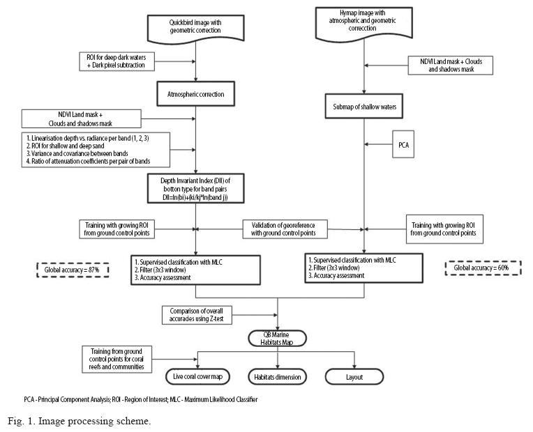
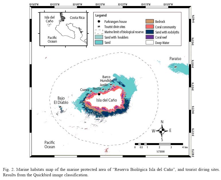
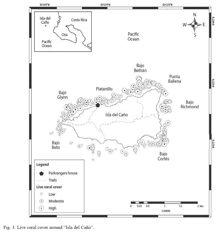
Image processing: A Hymap imagery from the island was obtained from the Costa Rican Airborne Research and Technology Application (CARTA) mission, in March 29, 2005, at 15:30 and at altitude of 7820m; a project of the National Aeronautics and Space Administration (NASA). This image had a medium spatial resolution (16m pixel size). It was georeferenced to ground control points from the island coastline and had atmospheric correction performed with the HyCorr software that converts the radiance values into apparent surface reflectance values (level compatible with ATREM3 processing). An unsupervised classification (30 classes) was performed on this image before going to the field as a guide for collecting the ground control points. The near infrared band (NIR) was used to mask out the land. Areas of cloud and shade were removed from the Hymap image by using manual digitized areas of interest in ENVI 4.1. software.
A Quickbird imagery with a resolution of 2m and a radius of 6km around the island was taken on February 24, 2007, at 16:28, after the fieldtrip. An atmospheric correction was performed to this image using the dark pixel subtraction (Lyzenga 1978, 1981; Armstrong 1993).
The images and the maps were processed using ENVI 4.1 and ArcGIS 9.1 and enhanced with a 2% linear stretching. The image processing procedure is summarized in Fig. 1.
Field work: The scientific expedition to "Isla del Caño" took place from January 25 to February 5, 2007, on the M/V Phoenix, as part of an initiative of The Nature Conservancy to improve the coastal and marine management of the Península de Osa. Ground control points from the coastline and marine environments of the island were collected during manta tow surveys (Rogers et al. 1994, Guzman et al. 2004) using a GPS Garmin GPSMAP 76S with an accuracy of ±10m. Visual identification of marine habitats from the surface was surveyed at 994 points to a maximum depth of 20m using pre-identified mapping categories.
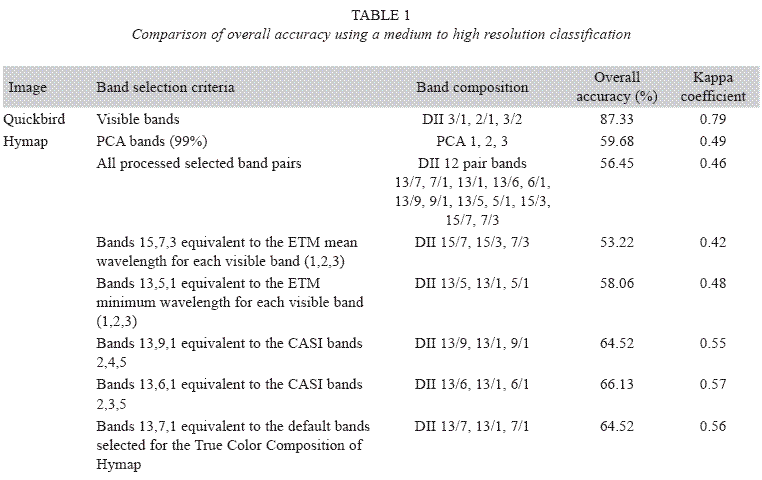
Image pre-processing: The level of geometric accuracy of the raw imagery was checked from the ground control points collected along the coastline. A Principal Component Analysis was performed to the 18 bands of the visible spectral range of Hymap in order to compute a component that includes the contributing effects of all these bands, to reduce redundancy in the datasets and to integrate radiometric variance associated with the multispectral bands (sensu Jensen 2004, Mishra et al. 2006). PCA bands 1, 2, 3 were selected since they accounted for 99% of the variance. The following band combinations were also processed for accuracy comparison, and the water column was corrected for these bands combination with the empirical method Depth Invariant Index (Lyzenga 1978, 1981): bands 15,7,3 equivalent to the ETM mean wavelength for each visible band (1,2,3); bands 13,5,1 equivalent to the ETM minimum wavelength for each visible band (1,2,3); bands 13,9,1 equivalent to the CASI bands 2,4,5; bands 13,6,1 equivalent to the CASI bands 2,3,5; and bands 13,7,1 equivalent to the default bands selected for the True Color Composition of Hymap. The water column was corrected in the Quickbird image using the "Depth Invariant Index" (Lyzenga 1978, 1981). The band pairs used for the Depth Invariant Index and final classification of this image were 3/1, 3/2, 2/1.
Marine Habitats Classification: Half of the ground control points were chosen randomly for image classification training data and the other half for accuracy assessment. From both images, supervised spectral signatures were generated for each habitat class using each point as a seed pixel for a "growing region of interest (ROI)", so the number of pixels for Hymap grew to 62 and for Quickbird to 5870. ROI’s were assessed with photointerpretation. The maximum likelihood was chosen for the supervised classification of both images and a 3x3 filter was applied to smooth the borders between categories in the final map.
The following seven marine habitat categories were used for a supervised classification of both images: 1. Coral community: coral colonies on sandy or rocky substrate; 2. Coral reef: corals forming a framework; 3. Bed rock: bare rocky substrate; 4. Sand: sandy substrate, soft bottom; 5. Sand with boulders: loose rocks in sandy bottom; 6. Sand with rodolyths: round red calcareous algae in sandy bottom; 7. Deep water: areas deeper than 20m.
Accuracy Assessment: Overall accuracy and Kappa coefficient were used to compare the classification results from both images. Kappa accounts for the amount of agreement that could be expected due to chance alone: poor = less than 0.20; fair = 0.20 to 0.40; moderate = 0.40 to 0.60; good = 0.60 to 0.80; and very good = 0.80 to 1.00 (Juurlink & Detsky 2005). Z tests were performed to test for significant differences between the Kappa coefficients. In order to determine the distribution of live coral cover, the following coral cover categories were used during the manta tow survey: 1. High: live coral>40%; 2. Moderate: live coral 20-40%, 3. Low: live coral <20%.
The overall classification accuracy for the different band combinations of Hymap is very similar (Table 1), so the different classifications were compared visually. The PCA bands 1,2,3, were selected for final classification of Hymap because they yielded a marine habitats map closer to what was found in the field.
Results
The overall accuracy for classification (7 classes) was slightly higher using Quickbird (87%) than using Hymap (60%), but the difference was not significant (Z=4.33, df=61/5869, p=0.05); the Kappa coefficient for Quickbird is good (0.79) and for Hymap is moderate (0.49) (Table 1); deep water and sand category showed the best accuracies. Quickbird improved the user’s accuracy for 4 classes, and it was more trustable because the image was taken at a date closer to the time of the field trip, so the map produced from Quickbird was selected to show the marine habitats distribution from "Isla del Caño" (Fig. 2).
Coral reefs and coral communities in "Isla del Caño" account for 13% (325 pixels) and 14% (353 pixels) from shallow environments (2537 pixels) of the Quickbird image respectively (this proportion was calculated omitting the deep water category, > 20m). The resulting area was 1412m2 (0.14ha) for coral communities and 1300m2 (0.13ha) for coral reefs (Table 2).
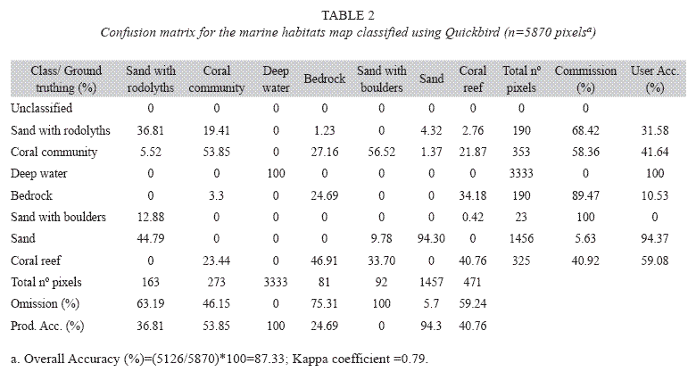
During classification the sand with rodolyths was confused mainly with coral community, coral community was mainly misclassified as sand with boulders, all deep water pixels were classified correctly, bedrock was misinterpreted mainly as coral reef, sand with boulders was mostly mistaken as sand with rodolyths and coral reef as bedrock. The user and producer accuracies in the classification of coral reefs and coral communities are relatively high (Table 2).
Live coral cover is higher in the northern and eastern coral reefs and communities, especially in the main coral flats of Bajo Glynn, Platanillo, Bajo Beltrán, Bajo Richmond and Bajo Cortés (Fig. 3).
Discussion
Green et al. (2000) suggest that 60 to 80% is the recommended overall accuracy for coastal and marine resources inventory, so both sensors were considered good for medium to high resolution mapping and quantification of these habitats, as an input for coastal and marine management plans (Table 1). The higher spectral resolution of Hymap compensates to some extent for the lack of spatial resolution. Although the main limitation of Hymap is the loss of the habitats particular shape, currently Hymap is more cost effective than Quickbird in the case of Costa Rica, since 80% of the country was covered with Hymap in 2005, and images have a much lower user cost than Quickbird. This fact justifies the use of Hymap images to continue mapping shallow marine habitats from Costa Rica, with a medium to high resolution. If there will be possibility to collect airborne data in the future in Costa Rica we would recommend lower flights to obtain higher spatial resolutions of less than 1-2m, and planning the field work at the same time than the flight to improve the classification accuracy, although this would be more expensive. Habitat categories could have been combined in three broad classes to yield an even higher accuracy, but the 7 classes map was considered of more value for management purposes. Other studies using high resolution sensors like Quickbird or IKONOS, same classification method and an average of seven habitat classes report similar overall accuracies (Maeder et al. 2002, Mumby & Edwards 2002, Mishra et al. 2006, Benfield et al. 2007). However Benfield et al. (2007) improved the classification of Quickbird by 17% with the "Object Oriented Method", which was not available for this study.
The user and producer accuracies in the Quickbird classification of coral reefs and coral communities, which are the habitats of more interest in this study, are relatively high (Table 2), however, as pointed by Mishra et al. (2006), there is still a significant amount of intermixing between marine habitats even at a spatial resolution of 2m.
Coral reefs and communities in "Isla del Caño" were impacted by the 1982-83 and the 1997-1998 El Niño, with loses of up to 50% of the live coral coverage (Guzman et al. 1987, Guzman & Cortés 1989, 2001), and by phytoplankton blooms in 1985, maybe associated with La Niña, with loss of some coral species from shallow reef zones (Guzman et al. 1990). Currently they are recovering (Guzman & Cortés 2001, Guzman et al. in prep.).
Management recommendations
"Isla del Caño" holds a great diversity of marine habitats and should be considered an important area within the Eastern Tropical Marine Corridor. Close to the island (4km to the northeast) there is a carbonated bank that is being used as a diving site called "Paraíso", but it is not within the Biological Reserve border which is 3km offshore. We recommend that this carbonate bank be considered as an important feature that should be represented by expanding the marine protected area to 4km offshore. There is some illegal commercial fishing that should be regulated to improve current protection. Many fish and shrimp fishing vessels are anchoring inside the Biological Reserve where they pollute the water with solid and liquid wastes. Patrolling is done mostly on the north side of the island and in day time. We strongly recommend reinforcing the vigilance all around the island and all day and night long. For this purpose the reserve needs more staff and navigation equipment. The protected area zoning, carrying capacity and behavior of vessels and visitors and other regulations according to the management plan should be respected in order to secure the long term protection of the island. Mainly, the number of diving sites should not be increased, the number of tourist vessels per buoy and visitors per day should be reduced, and fishing and fishing vessels should not be allowed at all within the reserve.
Acknowledgments
Thanks to O. Breedy, J.J. Alvarado, C. Fernández, A. Segura, E. Ruiz, C. Sevilla, M. Montero, C. Benavídez, D. Torres and the crew of the Phoenix for their help. We also thank L. Handley, from USGS, for the meticulous revision of the English language and content of this manuscript. This study was elaborated by CIMAR and the Smithsonian Tropical Research Institute, under contract #CR-OSA0038S from TNC, as part of their conservation activities in ACOSA.
Resumen
Isla del Caño es un área marina protegida en la costa del Pacífico de Costa Rica y está rodeada de arrecifes coralinos. La ecología de estos arrecifes coralinos ha sido estudiada a lo largo de 20 años pero todavía no habían sido mapeados. Los mapas son considerados una buena herramienta de investigación, planificación, manejo y monitoreo. Imágenes de mediana y alta resolución (Hymap 2005 y Quickbird 2007 respectivamente) fueron procesadas y clasificadas con el fin de evaluar y comparar su desempeño en la elaboración de un mapa de hábitats marinos. En el campo se realizaron sondeos tipo Manta para la identificación de siete hábitats marinos: 1. Comunidad coralina; 2. Arrecife coralino; 3. Roca; 4. Arena; 5. Arena con cantos; 6. Arena con rodolitos; y 7. Agua profunda. La exactitud de la clasificación resultó un poco mayor usando Quickbird (87%) que Hymap (60%), sin embargo la diferencia no era significativa. Se seleccionó el mapa resultante de la clasificación con Quickbird para representar los hábitats marinos de Isla del Caño. Este mapa puede ayudar a analizar el tamaño adecuado y la zonificación del área marina protegida.
Palabras clave: mapa de hábitats marinos, arrecifes de coral, Costa Rica, Isla del Caño, Hymap, Quickbird.
References
Armstrong, R.A. 1993. Remote sensing of submerged vegetation canopies for biomass estimation. Int. J. Remote Sens. 14: 621-627. [ Links ]
Benfield, S.L., H.M. Guzman, J.M. Mair & J.A.T. Young. 2007. Mapping the distribution of coral reefs and associated sublittoral habitats in Pacific Panama: a comparison of optical satellite sensors and classification methodologies. Int. J. Remote Sens. 28: 5047-5070. [ Links ]
Capolsini, P., S. Andréfouët, C. Rion & C. Payri. 2003. A comparison of Landsat ETM+, SPOT HRV, Ikonos, ASTER, and airborne MASTER data for coral reef habitat mapping in south Pacific Islands. Can. J. Remote Sens. 29: 187-200. [ Links ]
Cortés, J. & C.E. Jiménez. 2003a. Past, present and future of the coral reefs of the Caribbean coast of Costa Rica: 223-239. In: Cortés, J. (ed.). Latin American Coral Reefs. Elsevier Science, Amsterdam, Netherlands. [ Links ]
Cortés, J. & C.E. Jiménez. 2003b. Corals and coral reefs of the Pacific of Costa Rica: history, research and status: 361-385. In: Cortés, J. (ed.), Latin American Coral Reefs. Elsevier Science, Amsterdam, Netherlands. [ Links ]
Cortés, J., A.C. Fonseca & D. Hebbeln. 1996. Bottom topography and sediments around Isla del Caño, Pacific of Costa Rica. Rev. Biol. Trop. 44: 11-17. [ Links ]
Coté, I.M. & J.D. Reynolds. 2006. Coral Reef Conservation. Cambridge University, Cambridge, UK. [ Links ]
Fonseca, A.C. 1999. Bioerosión y bioacreción en arrecifes coralinos del Pacífico sur de Costa Rica. Tesis de Maestría, Universidad de Costa Rica, San José, Costa Rica. [ Links ]
Fonseca, A.C., H.K. Dean & J. Cortés. 2006. Non-colonial macro-borers as indicators of coral reef status in the south Pacific of Costa Rica. Rev. Biol. Trop. 54: 101-115. [ Links ]
Green, E.P., P.J. Mumby, A.J. Edwards & C.D. Clark. 2000. Remote Sensing Handbook for Tropical Coastal Management. UNESCO, Paris, France. [ Links ]
Guzman, H.M. 1986. Estructura de la comunidad arrecifal de la Isla del Caño, Costa Rica, y el efecto de perturbaciones naturales severas. Tesis de Maestría, Universidad de Costa Rica, San José, Costa Rica. [ Links ]
Guzman, H.M. 1988. Distribución y abundancia de organismos coralívoros en los arrecifes coralinos de la Isla del Caño, Costa Rica. Rev. Biol. Trop. 36: 191-207. [ Links ]
Guzman, H.M. & J. Cortés. 1989. Coral reef community structure at Caño Island, Pacific Costa Rica. P.S.Z.N.I: Mar. Ecol. 10: 23-41. [ Links ]
Guzman, H.M. & J. Cortés. 2001. Changes in reef community structure after fifteen years of natural disturbances in the eastern Pacific (Costa Rica). Bull. Mar. Sci. 69: 133-149. [ Links ]
Guzman, H.M., J. Cortés, R.H. Richmond & P.W. Glynn. 1987. Efectos del fenómeno de "El Niño-Oscilación Sureña" 1982/83 en los arrecifes de la Isla del Caño, Costa Rica. Rev. Biol. Trop. 35: 325-332. [ Links ]
Guzman, H.M., J. Cortés, P.W. Glynn & R.H. Richmond. 1990. Coral mortality associated with dynoflagellate blooms in the eastern Pacific (Costa Rica and Panama). Mar. Ecol. Prog. Ser. 60: 299-303. [ Links ]
Guzman, H.M., C.A. Guevara & O. Breedy. 2004. Distribution, diversity, and conservation of coral reefs and coral communities in the largest marine protected area of Pacific Panama (Coiba Island). Envir. Conserv. 31: 1-11. [ Links ]
Jensen, J.R. 2004. Introductory Digital Image Processing, a Remote Sensing Perspective. Prentice-Hall, New Jersey. USA. [ Links ]
Juurlink, D.N. & A.S. Detsky. 2005. Kappa statistic. Can. Med. Assoc. J. 173: 1-16. [ Links ]
Kutser, T., A.G. Dekker & W. Skirving. 2003. Modeling spectral discrimination of Great Barrier Reef benthic communities by remote sensing instruments. Limnol. Oceanogr. 48: 497–510. [ Links ]
Lyzenga, D.R. 1978. Passive remote sensing techniques for mapping water depth and bottom features. Appl. Opt. 17: 379-383. [ Links ]
Lyzenga, D.R. 1981. Remote sensing of bottom reflectance and water attenuation parameters in shallow water using aircraft and Landsat data. Int. J. Remote Sens. 2: 71-82. [ Links ]
Maeder, J., S. Narumalani, D.C. Rundquist, R.L. Perk, J. Schalles, K. Hutchins & J. Keck. 2002. Classifying and mapping general coral-reef structure using Ikonos data. Photogram. Eng. Remote Sens. 68: 1297-1305. [ Links ]
Mishra, D., S. Narumalani, D. Rundquist & M. Lawson. 2006. Benthic habitat mapping in tropical marine environments using Quickbird multispectral data. Photogram. Engin. Remote Sens. 72: 1037-1048. [ Links ]
Mumby, P.J. & A.J. Edwards. 2002. Mapping marine environments with IKONOS imagery: enhanced spatial resolution can deliver greater thematic accuracy. Remote Sens. Environ. 82: 248-257. [ Links ]
Mumby, P.J., E.P. Green, A.J. Edwards & C.D. Clark. 1997. Coral reef habitat mapping: how much detail can remote sensing provide? Mar. Biol. 130: 193- 202. [ Links ]
Nyström, M. & C. Folke. 2001. Spatial resilience of coral reefs. Ecosystems 4: 406-417. [ Links ]
Nyström, M., C. Folke & F. Moberg. 2000. Coral reef disturbance and resilience in a human-dominated environment. Trends Ecol. Evol. 15: 413-417. [ Links ]
Reaka-Kudla, M.L. 1997. The global biodiversity of coral reefs: a comparison with rain forests, p. 83-108. In M.L Reaka-Kudla, D.E. Wilson & E.O. Wilson (eds.). Biodiversity II: Understanding and Protecting our Biological Resources. National Academy, Washington, D.C., USA. [ Links ]
Richmond, R.H. 1993. Coral reefs: present problems and future concerns resulting from anthropogenic disturbance. Amer. Zool. 33: 524-536. [ Links ]
Rogers, C.S., G. Garrison, R. Grober, Z.M. Hillis & M.A. Franke. 1994. Coral Reef Monitoring Manual for the Caribbean and Western Atlantic. U.S. National Park Service, TNC, WWF, Virgin Islands, USA. [ Links ]
Wilkinson, C. 2008. Status of Coral Reefs of the World: 2008. Global Coral Reef Monitoring Network and Reef and Rainforest Research Center, Townsville, Australia. [ Links ]

