


Services on Demand
Journal
Article
 Article in xml format
 Article references
 Send this article by e-mail
Indicators
-
 Cited by SciELO
 -
 Access statistics
Related links
-
 Similars in
SciELO
Similars in
SciELO  uBio
uBio
Share

 Permalink
Revista de Biología Tropical
On-line version ISSN 0034-7744Print version ISSN 0034-7744
Rev. biol. trop vol.53 suppl.1 San José May. 2005
Beach dynamics and nest distribution of the leatherback turtle (Dermochelys coriacea )at Grande Riviere Beach,Trinidad &Tobago
Lori Lee Lum
Institute of Marine Affairs,Hilltop Lane,Chaguaramas,P.O.Box 3160,Carenage Post Office,Trinidad &Tobago,West Indies.Fax:868-634-2479;lleelum@ima.gov.tt
Received 15-I-2004. Corrected 27-XI-2004. Accepted 29-III-2005.
Abstract:Grande Riviere Beach in Trinidad and Tobago is an important nesting site in the Caribbean for the Critically Endangered leatherback sea turtle,Dermochelys coriacea .Community members were concerned that beach erosion and seasonal river flooding were destroying many of the nests deposited annually and thought that a hatchery was a possible solution.Over the 2001 turtle nesting season,the Institute of Marine Affairs (IMA) assessed the spatial and temporal distribution of nests using the Global Positioning System recorded to reference points,and beach dynamics using permanent bench mark profile stations,to determine areas of high risk and more stable areas for nesting.A total of 1449 leatherback nests were positioned.It was evident that at the start of the season in March,the majority of leatherback nests were deposited at the eastern section of the beach. After May,there was a continuing westward shift in nest distribution as the season progressed until August and beach erosion in the eastern section became predominant.The backshore remained relatively stable along the entire beach throughout the nesting season,and erosion was predominant in the foreshore at the eastern section of the beach,from the middle to the end of the season.Similar trends in accretion and erosion were observed in 2000.River flooding did not occur during the study period or in the previous year.With both high risk and more stable regions for turtle nesting available at Grande Riviere Beach,there was no compelling evidence to justify the need for a hatchery.
Keywords :Leatherback turtle,beach dynamics,turtle nest distribution,community participation,Trinidad and Tobago.
Trinidad and Tobago supports the second largest nesting assemblage of the endangered leatherback turtle (Dermochelys coriacea ) in the Western Hemisphere (Fournillier and Eckert 1998).In 1989,the Wildlife Section of the Forestry Division,Ministry of Agriculture, Land and Marine Resources,Trinidad and Tobago,entered into a co-management arrangement with coastal villagers and trained them in tour guiding for turtle conservation and ecotourism.Prior to this,the slaughter of leatherback turtles occurred rampantly on beaches over the nesting season.Two community-based organizations namely,Nature Seekers and the Grande Riviere Environmental Awareness Trust (GREAT)assisted by the Wildlife Section,were the pioneer groups to carry out tour guiding on nesting beaches to inform visitors about leatherback conservation.
The village of Grande Riviere in Trinidad traditionally supported an agricultural and fishing community.Grande Riviere Beach is a high density nesting site for the leatherback turtle (Chu Cheong 1990)and was assigned Prohibited Area status in 1997 under the Forests (Prohibited Areas)Order.This meant that during the March to August turtle nesting season, permits were required to enter these areas and a tour guide accompanied those wishing to view nesting turtles.In 1998,members of GREAT reported that based on observations,as much as 80%of the leatherback egg clutches were lost to beach erosion and annual flooding of the Grande Riviere River.The Institute of Marine Affairs (IMA)was approached to investigate the incidence of beach erosion and its effect on turtle egg clutches,with the aim of possibly establishing a hatchery.In 2000, the IMA initiated a monitoring programme to assess the beach dynamics at this nesting site. Grant funding from the International Fund for Animal Welfare,USA,made it possible to continue monitoring the beach dynamics over the 2001 nesting season,as well as to investigate the location of egg clutches so that high risk areas (areas with serious and predictable erosion)and more stable beach zones could be ascertained. In 2001 the Grande Riviere Tourism Development Organization (GRTDO), the successor to GREAT,was formed and the IMA worked with this community group on the current project.
The objectives of this project were to:
- Evaluate the spatial and temporal distribution of leatherback nests along Grande Riviere Beach;
- Assess the beach dynamics at Grande Riviere Beach during the 2001 turtle-nesting season to ascertain high risk and more stable areas for nesting;
- Produce a brochure to assist the community based organization to develop ecotourism and promote Grande Riviere as an area of biological diversity.
Study area
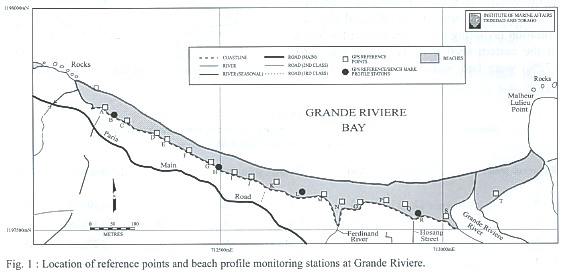
The village of Grande Riviere is located on the island of Trinidad in the Republic of Trinidad and Tobago.Block coordinates for Grande Riviere Beach are as follows: 1198000 mN-7120 0 0 mE ,119 750 0 mN- 712000 mE,1197500 mN-713500 mE and 1198000 mN-713500 mE.The beach is arcuate in shape and approximately 970 m in length from east to west and varies in width from 28 m in the western section to 60 m in the eastern section.The Grande Riviere River flows into the sea at the eastern end of the beach. Visitors and community residents use Grande Riviere Beach year-round for recreation,and leatherback turtles use it at night during their annual March to August nesting season.
Materials and methods
Data on the location of egg clutches and beach profiles was collected from March to August 2001 to determine erosion and accretion relative to 0.9 m,the average depth of leatherback nests (L.Chu Cheong,unpublished).Additionally zones of nesting activity, high-risk areas and more stable areas for nesting along Grande Riviere Beach were determined.The 2001 beach profile data was also compared with profiles taken in 2000 (IMA, unpublished)to determine trends in erosion and accretion.
Recording of turtle nest locations
Two members of GRTDO were trained to record the locations of leatherback nests along the beach.Twenty reference points were labelled A to T from west to east (Fig.1).The co-ordinates of the points were obtained using the Global Positioning System (GPS)so that every nest was recorded to a reference point that could then be positioned on a map.The GPS was accurate to 5 m.The arcuate shape of the beach did not allow for the reference points to be placed at equidistant intervals and they were placed between 25-95 m apart.Each nest was positioned to the closest reference point using a compass and a 100 m nylon-clad steel tape.The tape was drawn and secured from the base of the reference point to the centre of the nest being positioned and the distance in metres noted.Standing adjacent to the nest the compass was aligned along the tape facing back to the reference point and the bearing was recorded.Data collectors recorded the locations of nests deposited over a three-hour period each night during March to August 2001.
The distribution of nests was examined by fitting a multiple regression model of number of nests (square root)to distance from the western end of the beach and time in months.The square root transformation was needed to stabilize the variance.Data was processed using Microsoft Excel and Minitab software.
Beach profiles
A beach profile is a cross section of the beach along a transect that displays the changes in beach dynamics through variation in elevation at a given location over time.Four permanent bench marks were established in the backshore area of Grande Riviere Beach from which the beach profiles were done in 2000 and in the present study.The profiles were labelled B,H,L and R from west to east (Fig.1). Each profile was taken along a transect which was perpendicular to the beach.A Sokkia B2o survey level mounted on a tripod was used and readings were taken off a survey staff.The survey level readings started at the benchmark and then at measured horizontal distances to the low water mark.Beach profile data was used to determine the more stable and high risk zones for nesting using regression models that describe elevation as a function of distance from the vegetation line.For each profile two models were developed that described elevation when the sand levels were the highest and the lowest.The goal was to determine the regions where maximum changes in elevation were no more than 0.9 m.
This was achieved for each profile as follows:Yh =f (d);where Yh =the highest elevation,d =distance seaward from the vegetation line,f =denotes the regression model that relates elevation to distance.Yl =g (d);where Yl =the lowest elevation,d =distance seaward from the vegetation line,g =denotes the regression model that relates elevation to distance. The goal was to determine do,distance seaward from the vegetation line such that Yh -Yl =0.9 m.From the nature of this beach,the region between do and the vegetation line constitutes the more stable zone and between do and the low water mark is the high risk zone.
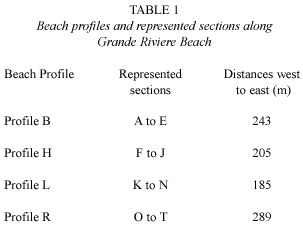
As it was not feasible to do beach profiles at every reference point,sections of the beach where beach dynamics were observed to be similar were grouped and represented by selected profiles (Table 1).Profile monitoring was carried out twice per month at the four stations,once during spring and once during neap tide,over the 2001 March to August nesting season.
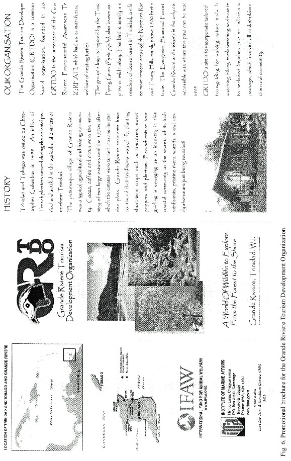
Promotional brochure for GRTDO
Meetings were held with members of GRTDO and Forestry Officers of National Parks Section,Ministry of Public Utilities and the Environment,Trinidad and Tobago,to introduce the idea of a promotional brochure for GRTDO.The National Parks Section had already formulated development plans for the area as Grande Riviere was to be designated a National Park.Background information on GRTDO,and the ideas on what members wanted to highlight in the brochure were obtained. There was consultation with the group during all stages of brochure production.
Results
Spatial and temporal nest distribution
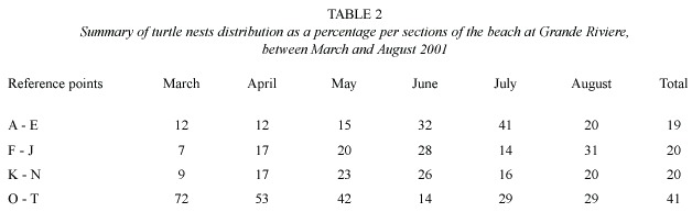
Over the 2001 turtle nesting season the location of 1449 leatherback nests were recorded.A summary of the percentage of nests and their distribution in relation to the reference point groups is given in Table 2.The data shows a trend in spatial and temporal nest distribution favouring the widest part of the beach at the eastern section in March,in which 61 (72%)were laid between reference points O to T.In April,nest distribution again appears to strongly favour this section with 293 (53%) nests deposited here with numbers decreasing westwards.The trend continued in May with 164 (42%)nests laid between O and T while the next favoured location with 72 (23%)nests between reference points K to N,again declining westwards.In June however there was a shift in nest distribution favouring the western section of the beach where 91 (32%)nests were laid between A to E,and the next favoured location 79 (28%)nests between F to J.As the end of the season approached nesting preference at the western end persisted in July when 35 (41%)of the nests were deposited between A to E.In August,turtles nesting late in the season showed no marked preference for either end of the beach with 11 (31%)nests recorded between F to J and 10 (29%)nests recorded between O and T.
The distribution of nests (square root) can be expressed as a function of distance and months from the western end of the beach throughout the nesting season (Fig.2).The model that adequately describes the number of nests is as follows:Y =-10.2 +4.9M +0.0074d -0.00113dM -0.432M2;R2=56.8%;where Y =is the natural logarithm of number of nests plus one,d =is the distance in metres from the extreme west end of the beach,M =month of the year (3,4,5,6,7,8).

The numbers of nests increased from March to April and then slowly declined to August.Spatially,nest density distribution shifted from the eastern end of the beach at the beginning of the season to the western end as the season progressed.
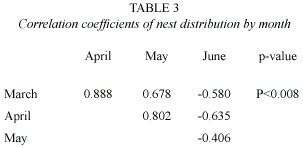
Correlation coefficients were determined for the distribution of nests during March to June 2001 (Table 3).There was a strong correlation between the distribution of nests in March and April (r=0.888)and March and May (r=0.678).However the relationship between March and June shows a negative correlation (r=-0.580).This indicated a shift in nest distribution from the eastern end to the western end of the beach.
Beach profiles
Results of regression models were used to determine the more stable and high risk zones for nesting along Grande Riviere Beach. These zones varied at each profile with the eastern section,Profile R,having the wider more stable backshore zone (Table 4).Figure 3 shows the observed seasonal changes in elevation at the four profiles along Grande Riviere Beach from March to July 2001.At Profile B on the western end of the beach, nesting activity took place from the vegetation line up to 32 m seaward.Sand accretion generally occurred from March to July in the foreshore resulting in a higher beach elevation at the end of the nesting season.
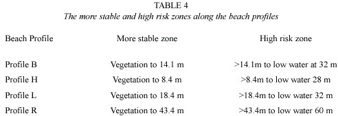
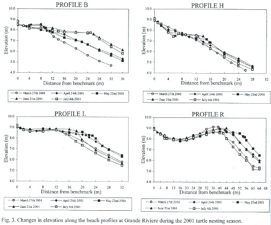
Profile H had a 25 m zone of nesting activity.Elevation changes were less than 0.9 m in the backshore and foreshore.Sand accretion occurred from March until June after which there was sand erosion until July.Beach elevation in the foreshore at the end of the season was higher than at the start of the season.
At Profile L there was a 26 m zone of nesting.The backshore was relatively stable throughout the nesting season.In the foreshore sand accretion of 0.8 m occurred until May, after which there was erosion of 1.3 m until July.At the end of the season there was a lower elevation in the foreshore than at the start of the season.
Profile R,on the eastern end had a wide nesting zone of 48 m.Accretion and erosion processes were similar to Profile L with a relatively stable backshore.In the foreshore sand accretion from March to May resulted in 1.4 m change in elevation. Subsequently there was sand loss of 1.9 m until July,leaving the foreshore at a lower elevation at the end of the nesting season.
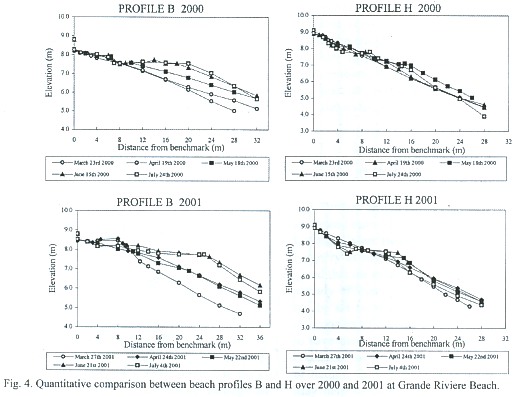
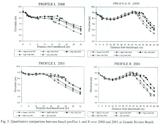
A qualitative comparison between beach profiles conducted from March to July 2000 and for the same period in 2001 shows the similarities and differences in erosion and accretion in successive years.At Profile B on the extreme western end of the beach there was a trend of sand accretion throughout the nesting season in both years.Profile H had the least change in beach elevation of all the profiles and beach elevation was slightly higher at the end of the season than at the start of the season in both years (Fig.4).Profiles L and R were alike in 2000 and 2001 exhibiting little change in elevation in the backshore and similar trends in accretion and erosion in the same months in the foreshore.Sand accretion was observed from March until May in 2000 and 2001.From May to June erosion processes were predominant, leaving the eastern section of the beach at a lower elevation than was initially recorded in March in both years (Fig.5).
Promotional brochure for GRTDO
The idea of a promotional brochure was well received by members of GRTDO and the Forestry Officers of National Parks Section as it complemented development plans that these organizations had for Grande Riviere (Fig.6). The IMA arranged for initial printing of the brochure and provided 1000 copies to GRTDO for distribution along with the master copy to enable further printing as funding becomes available.
Discussion
Leatherback nest distribution at Grande Riviere generally favoured the eastern section of the beach at the start of the nesting season.After May there was a westward shift in nesting preference as the season progressed. Beach erosion and accretion are natural processes along sandy beaches. Leatherback nesting beaches in St.Croix,U.S.Virgin Islands (Boulon et al.1996),Costa Rica (Leslie et al. 1996),French Guiana (Girondot and Fretey 1996)and Trinidad (Chu Cheong 1995)have all reported loss of egg clutches from beach erosion.Accretion and erosion were documented at Grande Riviere Beach over the 2001 leatherback turtle nesting season.Zonation of a typical beach includes the line of permanent vegetation,the backshore-the zone above the limit of the normal spring tide,the foreshore -the zone between tide levels to the limit of high water and the nearshore -the zone always submerged by water (King 1972).
Accretion was observed to be predominant in the foreshore zone from March to May 2001 along the entire beach.From May to July,erosion was predominant in the foreshore along the eastern section of the beach while accretion continued at the western end.The backshore remained relatively stable throughout the nesting season along the entire beach and provided more stable zones for egg clutches to incubate.Generally,the nesting season appeared to coincide with the period of sand accretion along Grande Riviere Beach.The observed shift westward in nest location after May appeared to occur as beach erosion in the eastern section became predominant.The beach dynamics at Grande Riviere Beach showed a similar trend of accretion and erosion both spatially and temporally,over the 2000 and 2001 nesting seasons.
Extensive egg loss from beach erosion was not observed during the study period.However the data has to be treated with caution,as other factors that affect nest loss also have to be considered. Members of GREAT had reported that many clutches were washed away due to the annual flooding of the Grande Riviere River and Godley et al.(1993)mentioned that prime nesting habitat is lost after rains in August.However the river did not flood in 2000 or 2001 as predicted.This could have been due to the fact that since 1998 the river mouth has not been allowed to close off as in previous years,as efforts were made by hotel establishments to keep it open using shovels in order to prevent flooding. Additionally a sand embankment has been built to protect business places from the effects of flooding (N.Alexander,pers.comm.2002).
Conclusions and recommendations
Turtles nested in both high risk fore-shore and more stable backshore regions along Grande Riviere Beach.In considering an in situ hatchery as suggested by GREAT,it should be noted that the existing more stable backshore is already efficiently used by turtles and should not be set aside for hatchery purposes.While the concept of moving turtle eggs to hatcheries to save them is well meaning,care should be taken not to over-estimate the consequences of natural threats.Natural selective pressures may help to shape biological mechanisms in developing hatchlings and provide them with a fitness advantage that may help them to cope better with such threats (Witherington 1999). With both high risk and more stable regions for leatherback nesting evident at Grande Riviere Beach,there was no compelling evidence to justify the need for a hatchery at present.
Further research on the hatch success of nests deposited on the eastern section of Grande Riviere Beach is needed to determine the rate of hatchling recruitment.Although this beach is relatively small,it provides nesting opportunities for hundreds of these Critically Endangered reptiles.The intensity of nesting is such that females arriving later in the season dig up earlier nests which allows resident dogs and scavenging black vultures (Coragyps atratus )easy access to excavated eggs.The effects of the Grande Riviere River in flood on the eastern section of the beach should also be examined to determine how flood events affect hatch success.Additionally,visitor traffic impacts the eastern end where the majority of clutches were deposited early in the season. Studies should be done to determine if hatch success is affected by sand compaction associated with visitors during the nesting season.
Acknowledgments
I gratefully acknowledge the following organizations and personnel whose contributions and assistance made this work possible: International Fund for Animal Welfare,USA, Institute of Marine Affairs,Trinidad & Tobago,Grande Riviere Tourism Development Organization,Grande Riviere Environmental Awareness Trust,National Parks Section and Wildlife Section Forestry Division,Ministry of Public Utilities and the Environment,Sunil Ramnath,Kevin Khan,Steve Lalbeharry, Jonathan Gomez,Nicola Ghouralal,Christian Pierre,Donna Spencer,Richard Hubbard, Charmaine O Brien-Delpesh,Amoy Lum Kong,Anthony Cummings,Hilary Baptiste, Len Peters,David Silverthorn,Tyron Peters, Nicholas Alexander,Ken Fournillier,Barry Mahabir,Stephen Poon,and Isaac Bekele.
Resumen
La playa de Grande Riviere en Trinidad y Tobago es un sitio importante de anidación en el Caribe de la tortuga baula,Dermochelys coriacea ;una tortuga marina en peligro de extinción.Los residentes estaban preocupados de que la erosión de la playa y las inundaciones estacionales estaban destruyendo muchos de los nidos y pensaron que un criadero era una solución.Durante la temporada de anidación del 2001,el Instituto de Asuntos Marinos de Trinidad y Tobago (Institute of Marine Affairs:IMA) determinó la distribución espacial y temporal de los nidos referenciados con respecto a varios puntos fijados por satélite (Global Positioning System),y la dinámica de la playa usando marcas permanentes del perfil de la playa, para determinar áreas de alto riesgo y áreas estables para los nidos.Se ubicó 1449 nidos.Fue evidente que al inicio de la temporada (marzo),la mayoría de los nidos estaban ubicados en el sector oriental de la playa.De abril a agosto la anidación se fue desplazando hacia el oeste conforme avanzaba la temporada,mientras que la erosión de la playa aumentaba en el sector oriental.La parte trasera se mantiene estable a lo largo de toda la playa durante toda la temporada de anidación.La erosión es predominante en el frente de playa del sector oriental,desde mediados hasta finales de la época de anidación.Patrones similares de "acreción "y erosión fueron observados en el 2000.No hubo inundaciones durante el estudio o en el año anterior. Como hay zonas de alto riesgo y zonas estables,no hay evidencia contundente para hacer un criadero.
Palabras clave :Baulas,dinámica de playa,distribución de nidos de tortugas,participación comunitaria,Trinidad y Tobago.
References
Boulon,R.H.Jr.,P.H.Dutton &D.L.McDonald.1996. Leatherback turtles,Dermochelys coriacea ,on St. Croix,U.S.Virgin Islands:fifteen years of conservation.Chelon.Conserv.Biol.2:141-147. [ Links ]
Chu Cheong,L.1990.Observations on the nesting population of leatherback turtles Dermochelys coriacea ,in Trinidad.Carib.Mar.Stud.1:48-53. [ Links ]
Fournillier,K.and K.L.Eckert.1998.WIDECAST Sea Turtle Recovery Action Plan for Trinidad and Tobago. CEP Technical Report.United Nations Environment Programme,Kingston,Jamaica. [ Links ]
Girondot,M.&J.Fretey.1996.Leatherback turtles, Dermochelys coriacea ,nesting in French Guiana, 1978-1995.Chelon.Conserv.Biol.2:204-208. [ Links ]
Godley,B.,A.Broderick,S.Blackwood,L.Collins,K. Glover,C.McAldowie,D.McCulloch &J.McLeod. 1993.1991 Survey of marine turtles nesting in Trinidad and Tobago.Marine Turtle Newsletter 61: 15-18. [ Links ]
King,C.A.1972.Beaches and Coasts.Edward Arnold (Publishers)Ltd.,London.570 p. [ Links ]
Leslie,A.,D.Penick,J.Spotila &F.Paladino .1996. Leatherback turtle,Dermochelys coriacea ,nesting and nest success at Tortuguero,Costa Rica,in 1990- 1991.Chelon.Conserv.Biol.2:159-168. [ Links ]
Witherington,B.E.1999.Reducing threats to nesting habitat,pp.179-183.In K.Eckert,K.Bjorndal,F. Abreu-Grobois &M.Donnelly (eds.)Research and Management Techniques for the Conservation of Sea Turtles.IUCN/SSC Marine Turtle Specialist Group Publication No.4.Pennsylvania,USA. [ Links ]

