


 Spanish (pdf)
 Article in xml format
 Article references
 Send this article by e-mail
 Cited by SciELO
  Similars in
SciELO
Similars in
SciELO 
 Permalink
Introduction
The exponential growth of world population, agriculture and intensive fertilization are related to the imbalance of global nitrogen processing (Galloway et al., 2008; Sutton et al., 2012). Before the industrial generation of fertilizers, nitrogen was naturally incorporated into the soil and the oceans by atmospheric or biological fixation, afterward recycled through bacterial denitrification (Olivares, Bedmar, & Sanjuán, 2013). Currently, about half of global nitrogen fixation occurs on land, and at least half of this fixation has its origin in intensive fertilization (Fowler et al., 2013). Overused reactive nitrogen forms (nitrate ion, nitrogen oxides, ammonia, and ammonium species) flow from application in agricultural lands towards watersheds or to the atmosphere, without healthy bioprocessing for the planet. (Devol, 2015). An excessive supply of nutrients to a water body causes abnormal growth of microorganisms and aquatic plants that reduce the penetration of radiation and consume dissolved oxygen (hypoxia). Aquatic species show diverse tolerance to moderate hypoxic conditions (less than 4 mgO2dissL-1) (Gilmore, Doubleday, & Gillanders, 2019; Johnson, Powers, Senne, & Park, 2009). In Latin America, the rate of nitrogen species entry into ecosystems is greater than in developed countries and threatens biodiversity hotspots on the continent (Austin et al., 2013).
Oceans denitrify at a higher rate and magnitude than land areas; notwithstanding, the efficiency depends on the oxygen supply (Canfield, Glazer, & Falkowski, 2010; Devol, 2015). The continuous nutrients reception causes oxygen depletion and also acidification (Fennel & Testa, 2019). Wetlands remove excess nutrients and decontaminate the water resource before entering the oceans (Fisher & Acreman, 2004; Hansen, Dolph, & Finlay, 2016). Nevertheless, wetlands are drained and used for monocultures that use intensive fertilization and distress the important ecological services they offer (Audet et al., 2015; Pirker, Mosnier, Kraxner, Havlík, & Obersteiner, 2016; Srinivas & Koh, 2016; Walsh et al., 2016).
Oil palm is a good example of an intensive crop that develops around the world, threatening forest and tropical wetlands (Dislich et al., 2017; Khatun, Reza, Moniruzzaman, & Yaakob, 2017). In Costa Rica, a combination of livestock, rice and intensive oil palm cultivation has develop and expanded in a territory located around a wetland area protected by national laws, the National Térraba-Sierpe Wetland (HNTS). This wetland is located in the Osa Peninsula, Costa Rica, and its ecological cleaning functions could be affected by intense anthropogenic activity (Gallmetzer & Schulze, 2015; Hernández-Alpízar, Mora-Molina, & Coy-Herrera, 2020; Taylor et al., 2018; Weintraub et al., 2018).
The Sierpe River crosses the HNTS and receives the agricultural effluents. Monthly monitoring was established at selected points of the river to analyze nitrates, dissolved oxygen (DO) and pH, as well as taking observations of the site in collaboration with the HNTS managers. The objective of this research was to describe, spatially and temporally, the nitrate concentrations in the Sierpe River associated with observations of the anthropogenic activities that surround it.
Method
A sampling strategy was designed in operational congruence with the "Fish Surveillance Program" included in the HNTS management plan. The sampling was stratified (random selection of sampling points) and BACI type, which is applied when the type of impact that may be affecting a wetland is known (eutrophication, change in species population). The use of physicochemical indicators with the observation of species and ecological impacts is a recommendation described in the EPA method for the design of wetland studies "Methods for evaluating Wetland Condition. #4 Study Design for Monitoring Wetlands" (Parker, 2002).
The fourteen sampling locations were registered using two GPS systems, MAP64SC (Figure 1). Monthly monitoring covered variations in weather conditions, agricultural, and urban activities during 2018. Agricultural patterns were visualized using the Google Earth Pro platform, 2020, version 7.3.3.7699 (64-bit). The anthropogenic activities were detailed with the park managers.
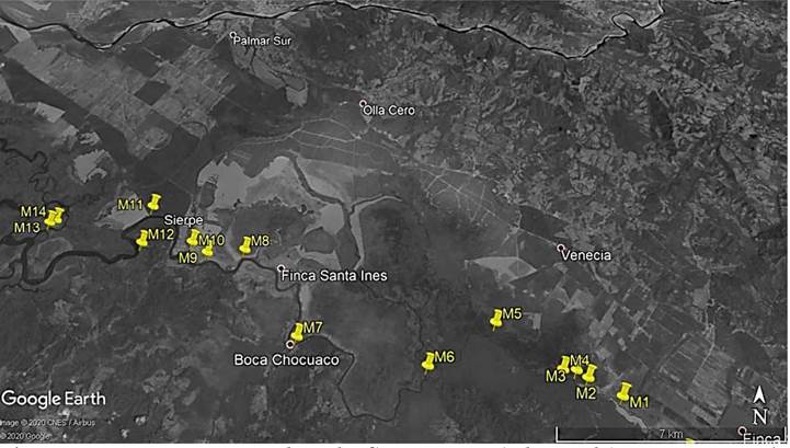
Figure 1 Monitoring network in the Sierpe River (7 km scale). Map generated with Google Earth Pro, 2020, version 7.3.3.7699 (64-bit). Build Date: Thursday, May 7, 2020, 12:27:47 AM UTC. Last access: 6/20/2020 (anthropogenic activity is maintained as 2018).
DO was measured in situ with a fluorometer, NEOFOX-GT from Ocean Optics. Conductivity and pH are also measured on site with Metrohm brand handheld device (model 914) and a fast-response pH electrode (iAquatrode). HDPE amber bottles (250 mL) were used to uptake water samples at a depth of 30 cm. The samples were transported and refrigerated the same day to the laboratory and analyzed the following days, as soon as possible and within a week.
For nitrates analysis, a UV-FIA spectroscopic set up described in CR20180476A were applied (Hernández-Alpízar & Coy-Herrera, 2019). The analytical system employs the miniature spectrometer Maya 2000-Pro (Ocean Optics), UV absorbance measurements were carried out at 223.96 nm
The connectivity of the sampled hydrological flow path is continuous. The following description of the sampling sites (Table 1) is obtained from the visits, the information provided by the HNTS managers, and the visual examination on the Google Earth map (Figure 1).
Table 1 Description of the sampling sites in the Sierpe River monitoring network in 2018.
| Sampling Site | Anthropogenic contributions | Description |
|---|---|---|
| M1 | Agricultural | Oil palm farms at short distance/Shallow low-flow waters |
| M2 | Agricultural | Oil palm farms at short distance/Shallow low-flow waters |
| M3 | Agricultural | Oil palm /Large cultivated areas/entrance to the Porvenir lagoon. |
| M4 | Agricultural | Oil palm /Large cultivated areas at medium distance from sample collection site |
| M5 | Agricultural | Rice/Oil palm at short distance from sample collection (<5 Km) |
| M6 | Agricultural | Oil palm /Large cultivated areas at medium distance (<10 Km) |
| M7 | Agricultural | Oil palm small crops/ Collection point on the cost side of the river |
| M8 | Agricultural | Rice/Oil palm at short distance from sample collection site |
| M9 | Agricultural/Urban | Rice/Oil palm at short distance from sample collection site |
| M10 | Agricultural/Urban | Urban and Oil palm /large cultivated areas at short distance |
| M11 | Agricultural | Oil palm /large cultivated areas at short distance |
| M12 | Agricultural | Oil palm /large cultivated areas at short distance |
| M13 | None | Sampling site at shallow waters of the river mouth |
| M14 | None | Sampling site at shallow waters of the river mouth |
Note: derived from research.
Analysis and results
Table 2 provides the georeferenced location of the sampling sites and the average pH of each collection site throughout the year. Crop fertilization is generally applied in transition periods from dry to rainy season. The pH minima correlate well with the type of water flow and the spatial and temporal distribution of anthropogenic activities. After the application of fertilizers (from the end of April to June), a drop in pH from M2 to M8 was observed, the sites with agricultural effluents. From M9 to M11 (mixed urban-agricultural activities) and from M12 to M14 (the shallowest water in the network), the acidity can be interpreted as a result of the nitrification process (conversion of ammonium ion to nitrate ion) occurring in the upper layer of shallow waters, with a change from equilibrium to hypoxic conditions in deep layers. Additional acidification can develop from aquatic plant nutrition and benthic denitrification in sediments, limited by the availability of dissolved organic matter that can also be supplied by absorption of atmospheric CO2 (Devol, 2015; Fennel & Testa, 2019; Taylor & Townsend, 2010).
Table 2 Location and pH of the sampling sites in the Sierpe River monitoring network (2018.)
| Sampling site | Latitude/length | pH (average) | Min* | Max | Standard deviation |
| M1 | 8°48'55.19"N/ 83°20'20.78"O | 7.30 | 6.48 | 7.90 | 0.46 |
| M2 | 8°49'12.84"N/ 83°20'53.94"O | 6.66 | 6.10 | 7.20 | 0.34 |
| M3 | 8°49'20.46"N/ 83°21'5.10"O | 6.69 | 6.45 | 6.90 | 0.16 |
| M4 | 8°49'20.82"N/ 83°21'19.08"O | 6.83 | 6.37 | 7.27 | 0.33 |
| M5 | 8°50'9.42"N/ 83°22'26.70"O | 6.75 | 6.26 | 7.12 | 0.28 |
| M6 | 8°49'20.82"N/ 83°23'39.30"O | 6.78 | 6.30 | 7.15 | 0.28 |
| M7 | 8°49'48.24"N/ 83°25'58.26"O | 6.76 | 6.24 | 7.28 | 0.33 |
| M8 | 8°51'27.30"N/ 83°27'6.42"O | 6.81 | 6.40 | 7.20 | 0.30 |
| M9 | 8°51'22.50"N/ 83°27'48.30"O | 6.96 | 6.50 | 7.45 | 0.32 |
| M10 | 8°51'34.98"N/ 83°28'7.32"O | 6.79 | 6.42 | 7.15 | 0.25 |
| M11 | 8°52'19.26"N/ 83°29'0.66"O | 6.62 | 5.28 | 7.22 | 0.56 |
| M12 | 8°51'32.46"N/ 83°29'4.32"O | 6.70 | 6.32 | 7.20 | 0.29 |
| M13 | 8°51'55.08"N/ 83°30'55.86" | 6.63 | 6.10 | 7.08 | 0.30 |
| M14 | 8°51'58.98"N/ 83°30'49.26"O | 6.66 | 6.30 | 7.10 | 0.30 |
* Minimum observed between late April and June.
Note: derived from research.
The lowest DO values were found in the sampling sites M2 to M8 (Table 3), between the months of April and June, that is, during the customary period of fertilizer application that takes place during the transition from the dry to rainy season. DO minimums correspond closely to levels considered as moderate and intense hypoxia. This is in line with the high proliferation of aquatic vegetation observed in the river surface in the same period, particularly for M2 to M4. These collection sites have low flow conditions and vegetation sometimes prevent navigation. Throughout the year, DO levels increased downstream M8 and at the end of the rainy season, DO levels increased for the entire sampling network.
Table 3 Dissolved oxygen concentration (mgL -1 ) in the Sierpe River monitoring network in 2018.
| Sampling site | Mean | Min* | Max | Standard Deviation |
| M1 | 9.30 | 8.01 | 10.4 | 1.0 |
| M2 | 5.04 | 1.72 | 6.97 | 2.1 |
| M3 | 4.98 | 1.60 | 7.80 | 2.3 |
| M4 | 5.30 | 1.67 | 7.93 | 2.5 |
| M5 | 6.30 | 3.51 | 8.97 | 2.4 |
| M6 | 6.84 | 4.72 | 9.74 | 2.1 |
| M7 | 7.13 | 4.98 | 9.35 | 1.8 |
| M8 | 7.31 | 5.15 | 9.85 | 2.0 |
| M9 | 7.56 | 5.23 | 9.62 | 1.7 |
| M10 | 7.43 | 5.50 | 9.82 | 1.6 |
| M11 | 7.42 | 5.44 | 10.3 | 1.7 |
| M12 | 7.17 | 5.45 | 8.64 | 1.3 |
| M13 | 7.77 | 6.07 | 10.0 | 1.5 |
| M14 | 7.59 | 5.90 | 9.72 | 1.6 |
* Minimum observed between May and July.
Note: derived from research.
Nitrate concentration varies widely throughout the year (Table 4). Maximum values occurred during fertilizer application in the months of April, May and June, particularly from M2 to M8 (agricultural areas) and M9-M10 which receive discharges from mixed urban-agricultural activities. These results indicated that an external event such as fertilization effectively changed the nitrate concentration. These sampling sites showed general averages in the upper limit of those reported in the literature (around 5 mgL-1) for surface waters impacted by agriculture (Taylor & Townsend, 2010). On the days of fertilization and transition from the dry to the rainy season, the concentration of nitrates in the Sierpe River occurred up to a maximum of 20.26 mgL-1 in M4. While in a nearby conserved natural region, only brief periods had been detected in which nitrate concentrations increased slightly during the peak of the dry season, probably due to nitrification in the soil and low flow rates (Taylor et al., 2018; Weintraub et al., 2018).
Table 4 Nitrate concentration (mgL -1 ) in the Sierpe River monitoring network in 2018.
| Sampling Site | Mean | Min* | Max** | Standard Deviation |
| M1 | 1.86 | 0.79 | 4.76 | 1.20 |
| M2 | 4.57 | 2.11 | 9.85 | 2.06 |
| M3 | 6.29 | 2.44 | 10.22 | 2.91 |
| M4 | 6.74 | 2.72 | 20.26*** | 5.25 |
| M5 | 6.29 | 2.32 | 12.46 | 2.98 |
| M6 | 7.05 | 3.52 | 14.98 | 3.40 |
| M7 | 6.12 | 1.94 | 13.91 | 3.65 |
| M8 | 7.32 | 4.17 | 11.33 | 2.48 |
| M9 | 7.53 | 3.76 | 16.29 | 4.21 |
| M10 | 6.24 | 1.47 | 17.83 | 4.32 |
| M11 | 4.81 | 2.41 | 8.07 | 1.74 |
| M12 | 6.01 | 3.69 | 8.02 | 1.68 |
| M13 | 5.77 | 2.98 | 8.03 | 1.49 |
| M14 | 5.04 | 2.60 | 6.78 | 1.19 |
* Minima observed between February-March and December; ** Maxima observed between April-June; *** 27/4/2018.
Note: derived from research.
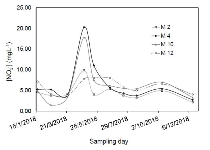
Finally, the annual distribution of nitrate concentration in selected sampling sites was observed as indicated in Figure 2. It can be observed that nitrate concentration values along the Sierpe River fluctuate and decreased until reaching a minimum at the mouth. This is an expected effect of nitrate dinamics in wetlands (Fisher & Acreman, 2004; Hansen et al., 2016).
The sampling points M4 and M10 with intense agricultural and nearby urban anthropogenic activity showed the most intense increase in nitrate concentration. With the rains in late April, fertilization of crops began, and the concentration of nitrates increased notably. After the rainy season in October, a second fertilization period was performed, and another increase was observed. Nevertheless, this increase was less pronounced, probably due to the dilution effect of the abundant flows resulting from the rainy season.
Conclusions
This research concluded that fertilization activities are directly related to the temporary increase in nitrate concentrations in the Sierpe River. The seasonal increase in aquatic vegetation observed by park managers could be a sign of present and future changes in the wetland ecosystem due to excess nutrients entering the water system.
Intensive agricultural production and nutrient cycling imbalance have negative effects on biological diversity and the life-sustaining functions of ecosystems. Its continuous loss is today among the main problems of the planet. Considering the findings of this work, it is evident that the protection of natural systems such as the National Térraba-Sierpe Wetland must be carried out beyond the limits of its territory, extending towards the water system in which they are located. In this framework, it is reasonable and recommended to create regulations for fertilizers addition or buffer zones to avoid the loss of invaluable resources for our own lives over time with the continuity of impacts.
Acknowledgments
The authors would like to thank the Vice Presidency for Research and Extension (VIE) of the Technological Institute of Costa Rica for financial and advisory support. We also thank the Center for Research in Environmental Protection (CIPA) and the Center for Research and Chemical and Microbiological Services (CEQIATEC) for laboratory support.
A special acknowledgment is extended to the HNTS park administration for showing interest in the research and granting permission to conduct it. The acknowledgment also goes to those responsible for the surveillance program for the valuable help provided.

