<?xml version="1.0" encoding="ISO-8859-1"?><article xmlns:mml="http://www.w3.org/1998/Math/MathML" xmlns:xlink="http://www.w3.org/1999/xlink" xmlns:xsi="http://www.w3.org/2001/XMLSchema-instance">
<front>
<journal-meta>
<journal-id>0034-7744</journal-id>
<journal-title><![CDATA[Revista de Biología Tropical]]></journal-title>
<abbrev-journal-title><![CDATA[Rev. biol. trop]]></abbrev-journal-title>
<issn>0034-7744</issn>
<publisher>
<publisher-name><![CDATA[Universidad de Costa Rica]]></publisher-name>
</publisher>
</journal-meta>
<article-meta>
<article-id>S0034-77442014000700004</article-id>
<title-group>
<article-title xml:lang="en"><![CDATA[Application of the Soil and Water Assessment Tool (SWAT Model) on a small tropical island (Great River Watershed, Jamaica) as a tool in Integrated Watershed and Coastal Zone Management]]></article-title>
<article-title xml:lang="es"><![CDATA[Aplicación de la herramienta de evaluación de suelo y agua (modelo SWAT) en una isla tropical pequeña (Gran Cuenca del Río, Jamaica) como una herramienta en la gestión integral de cuencas y manejo de la zona costera]]></article-title>
</title-group>
<contrib-group>
<contrib contrib-type="author">
<name>
<surname><![CDATA[Grey]]></surname>
<given-names><![CDATA[Orville P.]]></given-names>
</name>
<xref ref-type="aff" rid="A01"/>
</contrib>
<contrib contrib-type="author">
<name>
<surname><![CDATA[Webber]]></surname>
<given-names><![CDATA[Dale F. St. G.]]></given-names>
</name>
</contrib>
<contrib contrib-type="author">
<name>
<surname><![CDATA[Setegn]]></surname>
<given-names><![CDATA[Shimelis G.]]></given-names>
</name>
<xref ref-type="aff" rid="A02"/>
</contrib>
<contrib contrib-type="author">
<name>
<surname><![CDATA[Melesse]]></surname>
<given-names><![CDATA[Assefa M.]]></given-names>
</name>
</contrib>
</contrib-group>
<aff id="A01">
<institution><![CDATA[,University of the West Indies  ]]></institution>
<addr-line><![CDATA[Mona Kingston 7]]></addr-line>
</aff>
<aff id="A02">
<institution><![CDATA[,Florida International University  ]]></institution>
<addr-line><![CDATA[ Miami]]></addr-line>
</aff>
<pub-date pub-type="pub">
<day>00</day>
<month>09</month>
<year>2014</year>
</pub-date>
<pub-date pub-type="epub">
<day>00</day>
<month>09</month>
<year>2014</year>
</pub-date>
<volume>62</volume>
<fpage>293</fpage>
<lpage>305</lpage>
<copyright-statement/>
<copyright-year/>
<self-uri xlink:href="http://www.scielo.sa.cr/scielo.php?script=sci_arttext&amp;pid=S0034-77442014000700004&amp;lng=en&amp;nrm=iso"></self-uri><self-uri xlink:href="http://www.scielo.sa.cr/scielo.php?script=sci_abstract&amp;pid=S0034-77442014000700004&amp;lng=en&amp;nrm=iso"></self-uri><self-uri xlink:href="http://www.scielo.sa.cr/scielo.php?script=sci_pdf&amp;pid=S0034-77442014000700004&amp;lng=en&amp;nrm=iso"></self-uri><abstract abstract-type="short" xml:lang="en"><p><![CDATA[The Great River Watershed, located in north-west Jamaica, is critical for development, particularly for housing, tourism, agriculture, and mining. It is a source of sediment and nutrient loading to the coastal environment including the Montego Bay Marine Park. We produced a modeling framework using the Soil and Water Assessment Tool (SWAT) and GIS. The calculated model performance statistics for high flow discharge yielded a Nash-Sutcliffe Efficiency (NSE) value of 0.68 and a R² value of 0.70 suggesting good measured and simulated (calibrated) discharge correlation. Calibration and validation results for streamflow were similar to the observed streamflows. For the dry season the simulated urban landuse scenario predicted an increase in surface runoff in excess of 150%. During the wet season it is predicted to range from 98 to 234% presenting a significant risk of flooding, erosion and other environmental issues. The model should be used for the remaining 25 watersheds in Jamaica and elsewhere in the Caribbean. The models suggests that projected landuse changes will have serious impacts on available water (streamflow), stream health, potable water treatment, flooding and sensitive coastal ecosystems.]]></p></abstract>
<abstract abstract-type="short" xml:lang="es"><p><![CDATA[Aplicación de la herramienta de evaluación de suelo y agua (modelo SWAT) en una isla tropical pequeña (Gran Cuenca del Río, Jamaica) como una herramienta en la gestión integral de cuencas y manejo de la zona costera. La gran cuenca del Río Grande, ubicada en el noroeste de Jamaica, crítico para el desarrollo, particularmente para vivienda, turismo, agricultura y minería. Es una fuente de sedimentos y nutrientes de recarga para el ambiente costero incluyendo el Parque Marino Bahía Montego. Proponemos un marco integrado de modelado utilizando la herramienta de evaluación de suelo y agua (SWAT) y SIG. Las estadísticas de rendimiento del modelo calculadas para la descarga de alto flujo rindió una eficacia de Nash-Sutcliffe (NSE) de 0.68 y un R² de 0.70 sugiriendo una buena medición y correlación de descarga simulada (calibrada). Los estados insulares con frecuencia toman decisiones basándose en los impactos de la cuenca. Esto requiere un profundo entendimiento y análisis de factores como los recursos hídricos, uso del suelo/cobertura, sedimentos y nutrientes de recarga entre otros factores a nivel de cuenca. Con financiamiento del Instituto Interamericano para la investigación del Cambio Global (IAI) se examinó la aplicación del modelo de acceso libre en una cuenca jamaiquina. Los resultados de la calibración y validación para caudales fueron similares a los observados en los caudales respectivos, según lo indicado por la eficacia de Nash-Sutcliffe y el coeficiente de determinación. La calibración y validación de los resultados para el caudal son similares a los observados en el caudal. Durante la estación seca el escenario simulado en el uso de suelo urbano predijo un aumento de la escorrentía superficial superior al 150%. Durante la estación lluviosa el aumento de la escorrentía superficial se prevé que alcance desde 98 a 234% lo que representa un riesgo significativo de inundaciones, erosión y otros problemas ambientales. El modelo sugiere que cambios en los usos proyectados de suelo tendrán serios impactos sobre la disponibilidad de agua (caudal), salud de la cuenca, tratamiento de agua potable, inundaciones y ecosistemas costeros sensibles.]]></p></abstract>
<kwd-group>
<kwd lng="en"><![CDATA[Soil and Water Assessment Tool]]></kwd>
<kwd lng="en"><![CDATA[Integrated Coastal Zone and Watershed Management]]></kwd>
<kwd lng="en"><![CDATA[GIS]]></kwd>
<kwd lng="es"><![CDATA[Herramienta de Evaluación de Suelo y Agua]]></kwd>
<kwd lng="es"><![CDATA[zona costera integrada y manejo de cuencas]]></kwd>
<kwd lng="es"><![CDATA[SIG]]></kwd>
</kwd-group>
</article-meta>
</front><body><![CDATA[ <div style="text-align: justify;">     <div style="text-align: center;"><font style="font-weight: bold;"  size="4"><span style="font-family: verdana;">Application of the Soil and Water Assessment Tool (SWAT Model) on a small tropical island (Great River Watershed, Jamaica) as a tool in Integrated Watershed and Coastal Zone Management    <br>     <br> </span></font><font style="font-weight: bold;" size="4"><span  style="font-family: verdana;">Aplicaci&oacute;n de la herramienta de evaluaci&oacute;n de suelo y agua (modelo SWAT) en una isla tropical peque&ntilde;a (Gran Cuenca del R&iacute;o, Jamaica) como una herrramienta en la gesti&oacute;n integral de cuencas y manejo de la zona costera</span></font><font size="2"><span  style="font-family: verdana;"></span></font><br  style="font-family: verdana;"> </div> <br style="font-family: verdana;">     <div style="text-align: center;"><font size="2"><span      style="font-family: verdana;">Orville P. Grey<sup><a href="#1">1</a><a      name="3"></a>*</sup>,     Dale F. St. G.     Webber</span></font><a href="#1"><font size="2"><span      style="font-family: verdana;"><sup>1</sup></span></font></a><font     ]]></body>
<body><![CDATA[ size="2"><span style="font-family: verdana;">, Shimelis G. Setegn<sup><a      href="#2">2</a><a name="4"></a>*</sup>     &amp; Assefa M. Melesse<a href="#2"><sup>2</sup></a></span></font><br      style="font-family: verdana;">     </div>     <br style="font-family: verdana;">     <hr style="width: 100%; height: 2px;"><font style="font-weight: bold;"      size="3"><span style="font-family: verdana;">Abstract</span></font><br      style="font-family: verdana;">     <font size="2"></font><br style="font-family: verdana;">     ]]></body>
<body><![CDATA[<font size="2"><span style="font-family: verdana;">The Great River     Watershed, located     in north-west Jamaica, is critical for development, particularly for     housing, tourism, agriculture, and mining. It is a source of sediment     and nutrient loading to the coastal environment including the Montego     Bay Marine Park. We produced a modeling framework using the Soil and     Water Assessment Tool (SWAT) and GIS. The calculated model performance     statistics for high flow discharge yielded a Nash-Sutcliffe Efficiency     (NSE) value of 0.68 and a R<sup>2</sup> value of 0.70 suggesting good     measured and     ]]></body>
<body><![CDATA[simulated (calibrated) discharge correlation. Calibration and     validation results for streamflow were similar to the observed     streamflows. For the dry season the simulated urban landuse scenario     predicted an increase in surface runoff in excess of 150%. During the     wet season it is predicted to range from 98 to 234% presenting a     significant risk of flooding, erosion and other environmental issues.     The model should be used for the remaining 25 watersheds in Jamaica and     elsewhere in the Caribbean. The models suggests that projected landuse     changes will have serious impacts on available water (streamflow),     stream health, potable water treatment, flooding and sensitive coastal     ]]></body>
<body><![CDATA[ecosystems.</span></font><br style="font-family: verdana;">     <font size="2"></font><br style="font-family: verdana;">     <font size="2"><span style="font-family: verdana;"><span      style="font-weight: bold;">Key words: </span>Soil and Water     Assessment Tool, Integrated Coastal Zone and Watershed Management, GIS.</span></font><br      style="font-family: verdana;">     <font size="2"></font><br style="font-family: verdana;">     <font style="font-weight: bold;" size="3"><span      style="font-family: verdana;">Resumen</span></font><br      style="font-family: verdana;">     ]]></body>
<body><![CDATA[<font size="2"></font><br style="font-family: verdana;">     <font size="2"><span style="font-family: verdana;">La gran cuenca del     R&iacute;o Grande, ubicada en el     noroeste de Jamaica, cr&iacute;tico para el desarrollo, particularmente     para vivienda, turismo, agricultura y miner&iacute;a. Es una fuente de     sedimentos y nutrientes de recarga para el ambiente costero incluyendo     el Parque Marino Bah&iacute;a Montego. Proponemos un marco integrado de     modelado utilizando la herramienta de evaluaci&oacute;n de suelo y agua     (SWAT) y SIG. Las estad&iacute;sticas de rendimiento del modelo     calculadas para la descarga de alto flujo rindi&oacute; una eficacia de     ]]></body>
<body><![CDATA[Nash-Sutcliffe (NSE) de 0.68 y un </span></font><font size="2"><span      style="font-family: verdana;">R<sup>2</sup></span></font><font size="2"><span      style="font-family: verdana;"> de 0.70 sugiriendo una buena     medici&oacute;n y correlaci&oacute;n de descarga simulada (calibrada).     Los estados insulares con frecuencia toman decisiones bas&aacute;ndose     en los impactos de la cuenca. Esto requiere un profundo entendimiento y     an&aacute;lisis de factores como los recursos h&iacute;dricos, uso del     suelo/cobertura, sedimentos y nutrientes de recarga entre otros     factores a nivel de cuenca. Con financiamiento del Instituto     Interamericano para la investigaci&oacute;n del Cambio Global (IAI) se     ]]></body>
<body><![CDATA[examin&oacute; la aplicaci&oacute;n del modelo de acceso libre en una     cuenca jamaiquina. Los resultados de la calibraci&oacute;n y     validaci&oacute;n para caudales fueron similares a los observados en     los caudales respectivos, seg&uacute;n lo indicado por la eficacia de     Nash-Sutcliffe y el coeficiente de determinaci&oacute;n. La     calibraci&oacute;n y validaci&oacute;n de los resultados para el caudal     son similares a los observados en el caudal. Durante la estaci&oacute;n     seca el escenario simulado en el uso de suelo urbano predijo un aumento     de la escorrent&iacute;a superficial superior al 150%. Durante la     estaci&oacute;n lluviosa el aumento de la escorrent&iacute;a     ]]></body>
<body><![CDATA[superficial se prev&eacute; que alcance desde 98 a 234% lo que     representa un riesgo significativo de inundaciones, erosi&oacute;n y     otros problemas ambientales. El modelo sugiere que cambios en los usos     proyectados de suelo tendr&aacute;n serios impactos sobre la     disponibilidad de agua (caudal), salud de la cuenca, tratamiento de     agua potable, inundaciones y ecosistemas costeros sensibles.</span></font><br      style="font-family: verdana;">     <font size="2"></font><br style="font-family: verdana;">     <font size="2"><span style="font-family: verdana;"><span      style="font-weight: bold;">Palabras clave:</span> Herramienta de     ]]></body>
<body><![CDATA[Evaluaci&oacute;n de Suelo y Agua, zona costera integrada y manejo de     cuencas, SIG</span></font><br style="font-family: verdana;">     <br style="font-family: verdana;">     <hr style="width: 100%; height: 2px;"><font size="2"><span      style="font-family: verdana;">Increasing     population along with     increasing pressure on land for food, expansion, and the need for     infrastructure facilities have given rising alarm to conflicting     demands on finite land and water resources (Biswas, Sudhakar &amp;     Desai, 2002). Additionally, anthropogenic land use changes tend to     ]]></body>
<body><![CDATA[result in various geomorphic and hydrologic changes. These include     changes in the spatial and temporal aspects of flood peaks, and in the     extent and type of soil erosion (Magilligan &amp; Stamp, 1997).</span></font><br      style="font-family: verdana;">     <font size="2"></font><br style="font-family: verdana;">     <font size="2"><span style="font-family: verdana;">To adequately handle     the stresses     to our natural resources from climate change (e.g., flooding) and     &#8216;burgeoning populations&#8217; innovative methods have been conceptualized     over the years. As it relates to challenges at the watershed scale,     ]]></body>
<body><![CDATA[various management policies have been formulated under several titles;     the most common being integrated watershed management, integrated     environmental management, integrated water management, adaptive     management and integrated coastal zone management (Margerum, 1999;     Hooper, 2003; Ferreyra &amp; Beard, 2007).</span></font><br      style="font-family: verdana;">     <font size="2"></font><br style="font-family: verdana;">     <font size="2"><span style="font-family: verdana;">The primary focal     point of     watersheds is the river systems. Rivers provide the hydrologic link and     ]]></body>
<body><![CDATA[as such represent the key management unit within a watershed,     particularly in tropical island states and other equatorial regions.     Rivers provide the link between upland regions and coastal zones and     the regions surrounding them. By receiving water inputs from the land     through infiltration and groundwater inputs, they convey the excesses     from precipitation to areas such as seas, oceans, and lakes. Therefore,     the importance of a river&#8217;s ecological health is of paramount     importance as it reflects the status of the land surrounding it and     indicates the potential impact of practices within the watershed     (particularly upper watershed management areas) (Hooper, 2003; Jakeman     ]]></body>
<body><![CDATA[&amp; Letcher, 2003; Ferreyra &amp; Beard, 2007).</span></font><br      style="font-family: verdana;">     <font size="2"></font><br style="font-family: verdana;">     <font size="2"><span style="font-family: verdana;">In an effort to     achieve     environmental sustainability, an integrated watershed and coastal zone     management (IWCZM) approach must be incorporated, particularly as it     relates to coastal zones irrespective of their definition by geographic     or political boundaries. It is critical that an ecosystem-based     approach to management is taken that will ensure a holistic management     ]]></body>
<body><![CDATA[that integrates the impacts within the watershed and the resultant     effect cumulatively on our coastal zones (Nobre et al., 2010).</span></font><br      style="font-family: verdana;">     <font size="2"></font><br style="font-family: verdana;">     <font size="2"><span style="font-family: verdana;">According to the     Coral Reef     Alliance, coral reefs are among the world&#8217;s most productive ecosystems     (Goreau &amp; Hayes, 2008). They are a major natural resource providing     coastal protection, fisheries, and tourism income. The survival of     coral reefs is largely dependent on a set of environmental parameters     ]]></body>
<body><![CDATA[including low nutrient and sediment levels. Therefore, the management     of watersheds plays a vital role in their survival because they are     easily altered through land use changes (e.g., agriculture, degree of     deforestation, and the extent of coastal development) that affect the     quantity and quality of water flowing through a watershed and into the     coastal zone. Effective management of watersheds, in conjunction with     the coastal zone, can therefore improve the protection of the health of     our coral reefs, wetlands, and the people that rely on them (OECD,     1993; NRCA, 2001; OECS, 2002).</span></font><br      style="font-family: verdana;">     ]]></body>
<body><![CDATA[<font size="2"></font><br style="font-family: verdana;">     <font size="2"><span style="font-family: verdana;">The location of the     island, its     geography and geology make Jamaica susceptible to several natural     hazards such as earthquakes, landslides, hurricanes, floods and     droughts. The country has also acknowledged the increasing importance     of climate change due to the high vulnerability attributed to the high     concentration of development and infrastructure within the coastal     zone. Coupled with this, human induced pressures on ecosystem goods and     services are significant and highlighted within the major national     ]]></body>
<body><![CDATA[development plan, Vision 2030 (PIOJ, 2009).</span></font><br      style="font-family: verdana;">     <font size="2"></font><br style="font-family: verdana;">     <font size="2"><span style="font-family: verdana;">The current study     examines the     applicability of the Soil, Water and Assessment Tool (SWAT) on a     tropical island watershed to evaluate the ability of the model to     predict stream flow, and impacts of landuse changes on stream flow to     allow for better understanding of how these tools can aid in water     resources management. The following objectives were established:</span></font><br     ]]></body>
<body><![CDATA[ style="font-family: verdana;">     <font size="2"></font><br style="font-family: verdana;">     <font size="2"><span style="font-family: verdana;">Calibration and     validation of the     hydrologic component of SWAT model in the Great River Watershed;</span></font><font      size="2"><span style="font-family: verdana;">    <br>     <br>     Investigation of     fluctuations in     ]]></body>
<body><![CDATA[annual and seasonal stream flows and other hydrological parameters due     to three projected landuse scenarios.</span></font><br      style="font-family: verdana;">     <br style="font-family: verdana;">     <font size="2"><span style="font-family: verdana;">The Great River     Watershed is     located in the northwestern section of the island of Jamaica and is one     of 26 watersheds in the island. The Great River is approximately 74km     (46mi) long with an area of 327.27km<sup>2</sup> and has five major     tributaries:     ]]></body>
<body><![CDATA[Brown&#8217;s River, Sevens River, Quashies River, Lambs River and Roaring     River (Hayman, 2001; ARD, 2003). The Great River Watershed (GRW),     similar to most watersheds in Jamaica, is considered to be in a state     of environmental and economic decline. Agriculture, the major economic     activity, faces many challenges, and as returns on investment decline,     management is reduced. With reduced management comes less attention to     natural resource conservation. Although there are numerous small     communities scattered throughout the watershed, a large number of     squatter-type settlements exist. These settlements generally lack     adequate facilities for solid waste and sewage disposal (NRCA, 1997;     ]]></body>
<body><![CDATA[Hayman, 2001; STATIN, 2001).</span></font><br      style="font-family: verdana;">     <font size="2"></font><br style="font-family: verdana;">     <font size="2"><span style="font-family: verdana;">Regular monitoring     of water quality     within the watershed is not routinely carried out and as such     monitoring data are inconsistent (Hayman, 2001; Greenaway, 2004). The     water quality throughout the watershed is generally good with the     exception of fecal coliform contamination triggered by human and animal     fecal waste. The most recent assessment conducted from April 2002 to     ]]></body>
<body><![CDATA[July 2003 by the University of the West Indies (Greenaway, 2004)     suggested a river system in good health with relatively low nutrient     (primarily nitrogen and phosphorous) and high dissolved oxygen levels.     During the wet season when flow is fairly high nitrate levels were     often detectable. Although soil erosion potential is moderate to high     in the upper watershed, fairly low suspended sediment loads were     observed outside adverse weather patterns such as tropical storms and     hurricanes with significant precipitation. Flood plumes into the     coastal zone were only observed during these episodes. No pesticide     contamination was detected in the water samples taken during that     ]]></body>
<body><![CDATA[period (Greenaway, 2004).</span></font><br style="font-family: verdana;">     <font size="2"></font><br style="font-family: verdana;">     <font size="2"><span style="font-family: verdana;">There are relatively     few     peer-reviewed, published SWAT model applications in tropical regions     (Gassman, Reyes, Green &amp; Arnold, 2007; Oestreicher, 2008). This is     primarily due to the diversity of soils, species and climate of these     regions in comparison to those of temperate zones. The model is very     flexible and can be applied to a wide range of different environmental     conditions (Arnold &amp; Fohrer, 2005). The SWAT model, a freeware, was     ]]></body>
<body><![CDATA[developed by the USDA-Agricultural Research Service to assist with     assessment of watersheds ranging in sizes from small (a few hundred     square kilometers) to large watersheds (several thousand square     kilometers) (Neitsch, Arnold, Kiniry, Williams &amp; King, 2002). One     advantage of SWAT is the integration of the basin-scale model with GIS     providing much improved modelling linkages within a management basin     (Srinivasan &amp; Arnold, 1994). SWAT has several components including:     hydrology features, landuse, soil and slope attributes, and an improved     weather generator, among other factors. The model is complete with     documentation for equations and algorithms, a user manual describing     ]]></body>
<body><![CDATA[model inputs and outputs, and an ArcGIS interface manual (Arnold &amp;     Fohrer, 2005; Neitsch, 2005; Santhi, Srinivasan, Arnold &amp; Williams,     2006; Setegn, Srinivasan &amp; Dargahi, 2008). This study focuses on     the climate, land management and hydrology components.</span></font><br      style="font-family: verdana;">     <font size="2"></font><br style="font-family: verdana;">     <font size="2"><span style="font-family: verdana;">Although the model     has significant     advantages, it is important to recognize that limitations exist. SWAT     unfortunately is lacking in relation to the spatial representation of     ]]></body>
<body><![CDATA[the hydrological response units within sub-basins (Gassman et al.,     2007). The impacts on the predictions of evapotranspiration,     percolation and soil water content are significantly affected despite     the increase in spatial heterogeneity experiences with using large     sized sub-basins. Generally, it is found that surface runoff is not     significantly impacted by having larger and less sub-basins (Tripathi,     Raghuwanshi &amp; Roa, 2006). Additionally, SWAT incorrectly models     infiltration into aquifers in hard rock areas by assuming unlimited     capacity for water infiltration (Garg, Karlberg, Barron, Wani &amp;     Rockstrom, 2012, Batchelor, 2013). Despite these limitations, SWAT has     ]]></body>
<body><![CDATA[been applied in tropical regions as support system for environmental     management decision and policy making (Oestreicher, 2008). Oestreicher     in his study identified several studies where the application of the     SWAT model was met with acceptable performance. These included the     modelling of the effects of hypothetical land-use change scenarios     (primarily deforestation and reforestation of croplands) on flow,     sediment, and nutrient yields in Honduras, Costa Rica, Brazil, Kenya,     and China.</span></font><br style="font-family: verdana;">     <font size="2"></font><br style="font-family: verdana;">     <font size="2"><span style="font-family: verdana;">Of the two main     ]]></body>
<body><![CDATA[classes of     hydrological models identified in the literature: lumped and     distributed models; the former is considered generally not spatially     explicit largely representing a collection of changes in watershed     land-use while the latter is more spatially explicit and highlight     aspects such as surface runoff control factors. Despite the greater     data requirement of the latter model, which includes SWAT, there is     increased and improved forecasting ability of hydrological processes     (Ward &amp; Robinson, 2000; Evelyn, 2009). Several watershed modelling     software have been developed and are universally accepted such as the     ]]></body>
<body><![CDATA[Better Assessment Science Integrated Point and Nonpoint Sources     (BASINS), Modelo Hidrodin&acirc;mico (MOHID), SWAT, Water Quality     Analysis Simulation Program (WASP), and Watershed Modelling Systems     (WMS) among others (Erturk et al., 2006). Despite the vast wealth of     models, the diversity and cost-effective approach, as well as the     significantly large and growing model extensions has increased SWAT&#8217;s     application worldwide in developed and developing countries in a wide     range of watershed sizes and conditions. In many cases these     applications are requirements of government agencies evaluating the     impacts of different scenarios such as climate and land-use change     ]]></body>
<body><![CDATA[(Wang &amp; Yin, 1997; Gassman et al., 2007; Zhang, Srinivasan &amp;     Hao, 2007; Graiprab, Pongput, Tangtham &amp; Gassman, 2010).</span></font><br      style="font-family: verdana;">     <font size="2"></font><br style="font-family: verdana;">     <font style="font-weight: bold;" size="3"><span      style="font-family: verdana;">Materials and Methods</span></font><br      style="font-family: verdana;">     <font size="2"></font><br style="font-family: verdana;">     <font size="2"><span style="font-family: verdana;">In order to setup     SWAT various     ]]></body>
<body><![CDATA[inputs are required. These include: the Digital Elevation Model (DEM),     soil data, landuse data, stream network layers, weather data (rainfall     and temperature) and stream discharge data. A 56m DEM, supplied by Mona     GeoInformatics Institute (UWI-Mona, Jamaica), was used to determine the     slope and flow direction, which was used to determine sub-basin outlets     and areas contributing discharge to the outlets. Spatial datasets and     input files were organised according to guidelines by Neitsch et al.     (2002). Land-use/Land-cover data were supplied by the Forestry     Department of Jamaica. Weather data (daily rainfall and daily     temperature) were supplied by the Meteorological Service of Jamaica for     ]]></body>
<body><![CDATA[the period 1998-2006.Of the eight available stations only four stations     had complete data to undertake this study greater than 5 years between     the period 1960 and 2010. The decision criteria required using the     longest complete dataset exceeding 5 years for as many stations as     possible. Minor pre-processing of data was done to format the data     according to SWAT&#8217;s input style. Stream network and soil data were     supplied by the Water Resources Authority of Jamaica (WRA). Additional     data layers were supplied by the Natural Environment and Planning     Agency (NEPA). All digital datasets were projected to the Lambert     Conformal Conic Projection, and the projected coordinate system used     ]]></body>
<body><![CDATA[was the JAD 2001 Jamaica Grid.</span></font><br      style="font-family: verdana;">     <font size="2"></font><br style="font-family: verdana;">     <font size="2"><span style="font-family: verdana;">The SWAT 2005 model     was used     through the ArcSWAT interface embedded in the ArcGIS software. This     allows one to employ all available tools of ArcGIS in handling spatial     datasets. SWAT allows for the discretisation of a watershed by dividing     it into multiple sub-watersheds, which can then be further subdivided     into hydrologic response units (HRUs) that consist of homogeneous land     ]]></body>
<body><![CDATA[use, management, and soil characteristics (Neitsch, 2005). ArcGIS was     used to calculate: basic hydrologic information for the model (i.e.,     surface slope, water flow paths), the position and size of the HRUs,     and the necessary files to be used by SWAT (Winchell, Srinivasan, di     Luzio &amp; Arnold, 2007; 2009). The model, through the two phases     (land and stream routing), simulates the routines for     evapotranspiration, surface runoff, infiltration, percolation, return     flow, groundwater flow, channel transmission losses, channel routing,     and plant water use processes among others (Arnold, Srinivasan, Muttiah     &amp; Allen, 1999).</span></font><br style="font-family: verdana;">     ]]></body>
<body><![CDATA[<font size="2"></font><br style="font-family: verdana;">     <font size="2"><span style="font-family: verdana;">The modeling process     generated 30     HRUs that represent the entire GRW. Calibration of the model was     performed by comparing the simulated discharge with the monitoring     (measured) discharge data in situ. The measured data were divided into     two time periods covering the period 1998 to 2006 and represented     complete data for the longest time period with the most meteorological     stations in the watershed. The period 1998 to 2002 was selected for     calibration and the period 2002 to 2006 for validation.</span></font><br     ]]></body>
<body><![CDATA[ style="font-family: verdana;">     <font size="2"></font><br style="font-family: verdana;">     <font size="2"><span style="font-family: verdana;">Calibration of the     discharge was     achieved by adjusting the input parameters. The top ten parameters were     selected based on ranking achieved from the sensitivity analysis     conducted. Adjusting the selected parameters allowed for a better match     of measured and simulated discharges. The most sensitive parameters     were used to calibrate the model for the GRW. The first year data     (1998) was used as start-up/warm-up in the calibration process and was     ]]></body>
<body><![CDATA[therefore not included in the final model simulations. No formal     optimisation procedure during calibration exists and therefore     subjective decisions were generally made in calibrating the model     (Santhi et al., 2006). Modifications of values were made by     replacement, by addition of an absolute change or by a multiplication     of a relative change. A parameter is never allowed to go beyond the     model embedded pre-defined parameter range. Sensitivity tests and     preliminary model run were carried out in order to identify the most     sensitive model parameters. To avoid over parameterization, only the     most sensitive parameters (top 10 ranked) were adjusted in model     ]]></body>
<body><![CDATA[calibration.</span></font><br style="font-family: verdana;">     <font size="2"></font><br style="font-family: verdana;">     <font size="2"><span style="font-family: verdana;">Land use scenarios     used in this     study were designed to offer management planning for the protection of     the watershed by assessing the potential impact of land use changes on     hydrological parameters such as surface runoff, stream flows, and     potential evapotranspiration. Land use scenarios were designed around     real macro development possibilities within the watershed. Three     scenarios were designed as follows: (1) an increase in agriculture to     ]]></body>
<body><![CDATA[meet the projected demand of an increasing population and also to     support the tourism industry with locally grown produce, (2) an     increased conservation strategy by increasing the forest cover, and (3)     increased urbanization of the watershed in line with long-term     development plans to increase residential, tourism and commercial     activities with new and improved road network. Though hypothetical each     scenario mapped defines a potential maximum change in landuse that is     realistic in nature. These three major landuse scenarios were designed     by making changes to the SWAT reclassified landuse/land-cover map.</span></font><br      style="font-family: verdana;">     ]]></body>
<body><![CDATA[<font size="2"></font><br style="font-family: verdana;">     <font style="font-weight: bold;" size="3"><span      style="font-family: verdana;">Results</span></font><br      style="font-family: verdana;">     <font size="2"></font><br style="font-family: verdana;">     <font size="2"><span style="font-family: verdana;"><span      style="font-weight: bold;">Watershed modelling &amp;     streamflow:</span> The measured and simulated monthly discharges (<a      href="/img/revistas/rbt/v62s3/a04i1.jpg">Fig.     1</a>)     ]]></body>
<body><![CDATA[showed that the SWAT model mirrored the measured monthly flow very     closely. The mean calibrated measured monthly flow volume was 10.18cm     s<sup>-1</sup> (std. dev.= 9.94) slightly lower than the mean simulated     monthly     flow volume of 10.25cm </span></font><font size="2"><span      style="font-family: verdana;">s<sup>-1</sup></span></font><font      size="2"><span style="font-family: verdana;"> (std. dev.= 7.06). The     model was run during     the validation period on the basis of the parameters from the     calibration process only. The mean validation measured monthly flow     ]]></body>
<body><![CDATA[volume was 11.50cm </span></font><font size="2"><span      style="font-family: verdana;">s<sup>-1</sup></span></font><font      size="2"><span style="font-family: verdana;"> (std. dev.= 13.32),     slightly higher than the     mean simulated monthly flow volume of 10.66cm </span></font><font      size="2"><span style="font-family: verdana;">s<sup>-1</sup></span></font><font      size="2"><span style="font-family: verdana;"> (std. dev.= 7.72).</span></font><br      style="font-family: verdana;">     <font size="2"></font><br style="font-family: verdana;">     <font size="2"><span style="font-family: verdana;">The calculated model     ]]></body>
<body><![CDATA[performance     statistics for discharge yielded a Nash-Sutcliffe Efficiency (NSE)     value of 0.68 and a </span></font><font size="2"><span      style="font-family: verdana;">R<sup>2</sup></span></font><font size="2"><span      style="font-family: verdana;"> value of 0.70 suggesting a fairly good     correlation between measured and simulated (calibrated) discharge. The     validation period similarly demonstrated good model performance. The     NSE value of 0.61 and </span></font><font size="2"><span      style="font-family: verdana;">R<sup>2</sup></span></font><font size="2"><span      style="font-family: verdana;"> value of 0.67 also suggests a fairly     ]]></body>
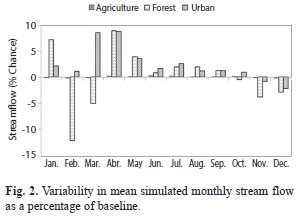
<body><![CDATA[good     correlation.</span></font><br style="font-family: verdana;">     <font size="2"></font><br style="font-family: verdana;">     <font size="2"><span style="font-family: verdana;"><span      style="font-weight: bold;">Landuse scenarios modelling &#8211;     Impact on stream flow: </span>The land-use change scenarios performed     reasonably well in comparison to the simulated baseline when calculated     for mean monthly stream flow (<a href="#Fig2">Fig. 2</a>). Simulated     mean annual stream     flow was less than measured stream flow using the validated period with     ]]></body>
<body><![CDATA[a range of 10.67cm </span></font><font size="2"><span      style="font-family: verdana;">s<sup>-1</sup></span></font><font      size="2"><span style="font-family: verdana;"> (agriculture) to 10.86cm     </span></font><font size="2"><span style="font-family: verdana;">s<sup>-1</sup></span></font><font      size="2"><span style="font-family: verdana;"> (urban). These     changes represented a 5.5% (urban) to 7.17% (agriculture) reduction in     annual mean stream flow when compared with the baseline measured flow     at the single discharge gauge station located approximately 3km from     the river sea interface. The simulated land-use changes suggest no     noticeable impact on mean stream flow with no more than a 3% increase     ]]></body>
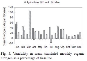
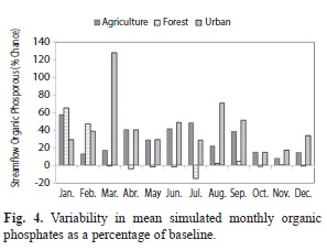
<body><![CDATA[for the dry season (December to April) and a 2% increase for the wet     season shown for the urban scenario when compared with the simulated     baseline.    <br>     <br> </span></font>     <div style="text-align: center;"><font size="2"><span  style="font-family: verdana;"><a name="Fig2"></a><img alt=""  src="/img/revistas/rbt/v62s3/a04i2.jpg"  style="width: 300px; height: 219px;"></span></font><br  style="font-family: verdana;"> <font size="2"><span style="font-family: verdana;"></span></font></div> <br style="font-family: verdana;"> <font size="2"><span style="font-family: verdana;">Although changes in simulated stream flow are fairly small in real values, the percent change in stream flow during the dry season for the forest and urban land-use scenarios are more exaggerated, ranging from an increase of 5% to 9% primarily during the dry season. Interestingly, the forest land-use scenario reflected similar fluctuations in reduction in stream flow during the same period particularly in the months of February and March while the agriculture scenario showed little or no change from the baseline throughout both dry and wet seasons.</span></font><br  style="font-family: verdana;"> <font size="2"></font><br style="font-family: verdana;"> <font size="2"><span style="font-family: verdana;"><span  style="font-weight: bold;">Land-use scenarios modelling &#8211; Impact in stream nutrients:</span> Simulated agriculture and urban land-use changes produced consistent increases in organic nutrients for most months with the greatest increase (106%) being predicted under simulated urban land use changes in March. The greatest increase in organic nitrogen for the agriculture land-use change was observed for the dry season month of January (~56%) when stream flow is lower and outside the main growing season of April-May. Increases exceeded 12% for all months in the year. Increases of 20-40% were also observed for wet season months of May to September when average monthly stream flow increases (<a href="#Fig3">Fig. 3</a>).</span></font><br  style="font-family: verdana;">     <br>     <div style="text-align: center;"><a name="Fig3"></a><img alt=""  src="/img/revistas/rbt/v62s3/a04i3.jpg"  style="width: 300px; height: 212px;">    <br> </div> <br style="font-family: verdana;"> <font size="2"><span style="font-family: verdana;">Simulated agriculture and urban land-use changes produced consistent increases in organic phosphorous for each month with urban land use changes in March having the highest % change. Increases of 28-48% were also observed for wet season months of May to November for organic phosphorous within the stream (<a  href="#Fig4">Fig. 4</a>). Similar to organic nitrogen, phosphate contributions to stream flow were greatest during low-flow period.    <br>     ]]></body>
<body><![CDATA[<br> </span></font>     <div style="text-align: center;"><font size="2"><span  style="font-family: verdana;"><a name="Fig4"></a><img alt=""  src="/img/revistas/rbt/v62s3/a04i4.jpg"  style="width: 297px; height: 227px;"></span></font><br  style="font-family: verdana;"> <font size="2"><span style="font-family: verdana;"></span></font></div> <br style="font-family: verdana;"> <font size="2"><span style="font-family: verdana;"><span  style="font-weight: bold;">Land-use scenarios modelling &#8211; Impact on surface runoff to streams:</span> Increase in surface runoff were generally observed for all three land-use changes, however forest land-use change recorded marginal decreases in some dry season months. While agriculture land-use scenario projected small increases in surface runoff contribution to stream flow ranging from 3.13% to 12.70%, forest land use change contributions ranged from -5.1% to 52%. The urban land-use scenario unlike the others projected greater monthly increases in surface runoff contributions. During the dry season the increase in surface runoff was in excess of 150% for the urban scenario. During the wet season the increase in surface runoff had a range of 98% to 234% (<a href="/img/revistas/rbt/v62s3/a04i5.jpg">Fig. 5</a>).    <br>     </span></font><br style="font-family: verdana;">     <font style="font-weight: bold;" size="3"><span      style="font-family: verdana;">Discussion</span></font><br      style="font-family: verdana;">     <font size="2"></font><br style="font-family: verdana;">     <font size="2"><span style="font-family: verdana;">Despite the slight     over-estimation     ]]></body>
<body><![CDATA[at some peaks, the SWAT watershed model was able to adequately match     the measured flow. Peak flows tend to be over-predicted for calibrated     discharge; this difference may be attributed to rapid discharge during     and following periods of storm events. Validation of the model is     important in instilling confidence in the suitability and applicability     of the model. The storm events may not be well captured due to the     location from which rainfall station data used in the simulations was     acquired. It is possible that the under-estimation is in part due to     the model&#8217;s assumption of uniform soil texture and land use in the     watershed that is not a real world scenario. The under-prediction     ]]></body>
<body><![CDATA[observed in this study has been reported in other studies for rainy     periods (Tripathi, Panda &amp; Raghuwanshi, 2003; Gassman et al.,     2007). However, the statistical evaluations for both calibration and     validation can be considered to be satisfactory based on the criteria     outlined by Moriasi et al. (2007). Therefore, based on the statistics     returned, the SWAT model can be considered an effective tool in     simulating the hydrology of tropical island watershed such as the Great     River Watershed in Jamaica, although the simulated results, though     realistic, can only be considered as experimental and ongoing and not     conclusive or final.</span></font><br style="font-family: verdana;">     ]]></body>
<body><![CDATA[<font size="2"></font><br style="font-family: verdana;">     <font size="2"><span style="font-family: verdana;">Stream flow is     projected to be     impacted most with an increased urban landscape. An increase in the     forest and agricultural land-use change does not suggest any real     measureable increases in stream flow. Simulated agriculture land-use     change has less of an impact and may be attributed to the regions     within the watershed where substantive simulated changes were made. The     lower-reach had little or no change in agriculture land-use,     significant changes were made to the mid- and upper-reach, particularly     ]]></body>
<body><![CDATA[the upper reach in the southern portion of the watershed. The southern     section of the watershed has numerous ridges and potentially impacts on     the distribution of rainfall to a greater extent than is experienced in     the mid- to lower-reach. An increase in forest cover may have a more     pronounced effect on stream flow in the dry season when     evapotranspiration is expected to be highest. The modeled urban     scenario revealed the very real possibility of surface runoff     increasing to levels that may become disastrous. The drive to increase     the agricultural component of the watershed may be setback due to a     reduction in available water and soil moisture content, an increase in     ]]></body>
<body><![CDATA[surface runoff, and a reduction in forest cover that provides the     microclimate needed. The potential impacts to life and property are     very significant.</span></font><br style="font-family: verdana;">     <font size="2"></font><br style="font-family: verdana;">     <font size="2"><span style="font-family: verdana;">Little or no data     were available     for hydrological parameters throughout most of the watershed. Where     available the data were often incomplete due to faulty or     non-functional equipment. No adequate historical land-use maps for the     watershed were available to observe change in land-use over a prolonged     ]]></body>
<body><![CDATA[period of time to compare with the macro changes in the hypothetical     scenarios. A better spatial coverage of functioning rain gauges would     afford a much better modelling effort to accurately gauge the impact of     rainfall on land-use and its subsequent impact on stream flow. The     results obtained from the model can be used exclusively or as an input     of river &#64258;ow and loads to the other models such as the MOHID estuarine     models. As such, the model can be utilized to focus on possible     interactions between coastal and riverine ecosystems and the social     environment through incorporating three key activities: the nutrient     loads generated from land based activities transported by surface     ]]></body>
<body><![CDATA[waters and groundwater, use of coastal fauna associated with income     generating activities such as fishing and dredging, and site specific     key features arrived at in consultation with stakeholders and resource     managers.</span></font><br style="font-family: verdana;">     <font size="2"></font><br style="font-family: verdana;">     <font size="2"><span style="font-family: verdana;">Nutrient     contamination is a very     important aspect of water quality monitoring in rivers and coastal     environments globally. In Jamaica, the impact of nutrient contamination     has been evident in some rivers and along the coast particularly in     ]]></body>
<body><![CDATA[areas with coral reefs (Hayman, 2001; Greenaway, 2004; Espeut, 2012).     This is evidenced by instances of fish kills, coral reef damage, and     eutrophication. Levels of nutrients within stream flow suggest     potential nutrient contamination with simulated land-use change     scenarios, and are corroborated by existing data from the National     Water Commission for the GRW during the period 2006-2010 showing     elevated levels of nitrates and phosphates at the point of extraction,     as well as water quality data within the river at various sections     (Hayman, 2001; Greenaway, 2004). The dataset indicates several     instances of coliform tests exceeding the standard of 300MPN/100ml as     ]]></body>
<body><![CDATA[well as the domestic limit of 0MPN/100ml for potable water. Recorded     spikes of 221 and 19.4mg PO<sub>4</sub> L<sup>-1</sup> were recorded in     June 2008 and October     2009 as well as nitrates routinely at or near the upper limit standard     of 7.5mg </span></font><font size="2"><span      style="font-family: verdana;">PO<sub>4</sub></span></font><font      size="2"><span style="font-family: verdana;"> </span></font><font      size="2"><span style="font-family: verdana;">L<sup>-1</sup></span></font><font      size="2"><span style="font-family: verdana;">. Land-use change     influences suggest local water     ]]></body>
<body><![CDATA[balance and quality will be significantly impacted as suggested in the     literature (Heathwaite &amp; Johnes, 1996; Fohrer, M&ouml;ller &amp;     Steiner, 2002; Heuvelmans et al., 2005; Abbaspour et al., 2007). This     is easily proved when the sources of organic nitrogen within the     watershed such as sewage from pit latrines, agriculture, urban, and     rural developments are taken into consideration. Greenaway (2004) found     occasionally elevated levels near the mouth of the river; however,     concentrations were frequently elevated at some mid to upper reach     stations. These locations are typical of small farm holdings with     cattle. This corresponds well with findings in the 2001 Ridge to Reef     ]]></body>
<body><![CDATA[report (Hayman, 2001). There are no centralized sewerage systems within     the watershed, and an increase in residential homes is expected to     impact on this and other water quality parameters.</span></font><br      style="font-family: verdana;">     <font size="2"></font><br style="font-family: verdana;">     <font size="2"><span style="font-family: verdana;">Phosphorus is     generally present in     stream flow as dissolved or particulate matter, and is a vital plant     nutrient and possibly the most limiting nutrient to plant growth in     fresh water. It is rarely found in significant concentrations in     ]]></body>
<body><![CDATA[surface waters. As such, its presence in fresh water systems may lead     to extreme algal growth, hence eutrophication (Hayman, 2001; Fohrer et     al., 2002; Greenaway, 2004; Qi et al., 2009). Sources of phosphorous     are similar to those identified above for nitrogen. In urban and rural     settings, the use of detergents is a major source. Within the GRW,     washing of clothes and personal effects such as cars is a common     occurrence as well as bathing in rivers and streams. The increase in     organic nitrogen projected is understandable particularly in the     agriculture scenario due to the possibility of increased use of     fertilizers. In regards to organic phosphorous, an increase in urban     ]]></body>
<body><![CDATA[component will likely yield an increase in use of soaps and detergents     and other commercial products that would increase the phosphorous     component particularly in runoff.</span></font><br      style="font-family: verdana;">     <font size="2"></font><br style="font-family: verdana;">     <font size="2"><span style="font-family: verdana;">Many bodies of     freshwater are     currently experiencing influxes of phosphorus and nitrogen from outside     sources. The increasing concentration of available phosphorus allows     plants to assimilate more nitrogen before the phosphorus is depleted.     ]]></body>
<body><![CDATA[Thus, if sufficient phosphorus is available, elevated concentrations of     nitrates will likely lead to algal blooms (Dunne &amp; Leopold, 1978;     Easton et al., 2008; Harden, Foster, Morris, Chartrand &amp; Henry,     2009). Algal blooms observed throughout the watershed were more     noticeable in the dry season. However, in most instances, these blooms     were related to areas prone to low or no flow where stagnant standing     bodies of water occur until a rain event that disperses the generated     plant material. Interestingly, Hayman (2001) and Greenaway (2004) have     both recommended a systematic monitoring of nutrient levels throughout     the watershed, particularly the central sections that are utilized for     ]]></body>
<body><![CDATA[citrus orchards and coffee farms as well as an agricultural research     station.</span></font><br style="font-family: verdana;">     <font size="2"></font><br style="font-family: verdana;">     <font size="2"><span style="font-family: verdana;">Predictably, surface     runoff is     projected to increase greatly once the land cover is dominated by hard     surface which is a characteristic of urbanization or where forested     land cover has reduced allowing for greater sheet flow where     agriculture is not dominated by tree crops. This is well represented     using the simulated urban land-use scenario wherein surface runoff     ]]></body>
<body><![CDATA[increases nearly three-fold the baseline to a high of mean annual of     19.88 mm of water. Although an increase is projected for simulated     increase in forest cover, the change is marginal in real terms.     Simulating varied land-use changes on a greater spatial scale may     result in even greater surface runoff for urban land-use changes.</span></font><br      style="font-family: verdana;">     <font size="2"></font><br style="font-family: verdana;">     <font size="2"><span style="font-family: verdana;">The reduced surface     runoff     potential for agriculture and forest scenarios may translate to reduced     ]]></body>
<body><![CDATA[flooding incidences but may have impact on water availability, quality     (increased concentrations) and sustenance of critical habitats. An     increase of the projected magnitudes for the urban scenario will no     doubt increase water availability but depending on how that increase is     delivered spatially, it could be a significant environmental and     socio-economic impact risk. Such increases bring with it the potential     for flooding and transference of pollutants to sensitive areas and     ecosystems such as flood plains and coral reefs.</span></font><br      style="font-family: verdana;">     <font size="2"></font><br style="font-family: verdana;">     ]]></body>
<body><![CDATA[<font size="2"><span style="font-family: verdana;">The significant     increase in surface     water observed for the urban scenario may have huge impacts on stream     health that will negatively impact on the treatment services of potable     water. This is required bearing in mind the expected increase in     population, and also the projected increase in tourism related services     such as hotels and eco-adventure tours. Improved watershed management     is recognized as a critical area of need in Jamaica. These improvements     are geared towards providing reliable and adequate supplies of clean     water for agriculture, industry, tourism, urban and rural populations,     ]]></body>
<body><![CDATA[as well as for ecosystem sustainability. This is well documented in a     review of the watershed (Hayman, 2001; ARD, 2003).</span></font><br      style="font-family: verdana;">     <font size="2"></font><br style="font-family: verdana;">     <font size="2"><span style="font-family: verdana;">Future watershed     hydrologic changes     due to land conversion are expected to be site-specific, and climate     variability is an important factor controlling basin hydrologic     processes (Qi et al., 2009). Agricultural activities on steep slopes     have long been recognized as the single most important cause of the     ]]></body>
<body><![CDATA[degradation of watersheds in Jamaica (NRCA, 1999; Hayman, 2001).</span></font><br      style="font-family: verdana;">     <font size="2"></font><br style="font-family: verdana;">     <font size="2"><span style="font-family: verdana;">The increase run-off     in urban areas     (particularly residential) and maintenance and potential increase in     agriculture within the GRW has and will impact significantly on the     dynamics of suspended sediments and nutrient contribution to stream     flow. The GRW is dependent on the episodic and seasonal flows to     maintain watershed health. Suspended sediment transport is greatest     ]]></body>
<body><![CDATA[during these events. The temporal pattern of these events (short     duration and heavy flow) aids greatly in the removal of material     reducing the likely entrainment of material along the stream flow.</span></font><br      style="font-family: verdana;">     <font size="2"></font><br style="font-family: verdana;">     <font size="2"><span style="font-family: verdana;">Based on these     dynamics it is     possible that there is an efficient system of material transport and     limited impact from channel sedimentation and de-nitrification     processes (Brodie &amp; Mitchell, 2005). However, with an increase in     ]]></body>
<body><![CDATA[nutrients particularly from any increases in agriculture and urban     landscape coupled with potential reduction in rainfall, it is likely     that without proper management this natural resource could be     negatively impacted for future use.</span></font><br      style="font-family: verdana;">     <font size="2"></font><br style="font-family: verdana;">     <font size="2"><span style="font-family: verdana;">The integrated     watershed and     coastal zone management approach must be used to tackle issues such as     watershed health, stream water quality, coastal zone and sensitive     ]]></body>
<body><![CDATA[habitat sustainability in the context of various resource managers.     There must be a concerted effort to ensure that these managers are all     speaking from the same platform. Presently, resource managers typically     utilize software that are restricted to particular agencies with a     difficult process of translating to the needs of each other. The     application of resources that are freely available, proven in the field     in developed and developing countries, and have produced robust results     should be made available as part of our planning arsenal to ensure all     agencies are able to interact in a cohesive manner. SWAT is one such     tool that Jamaica can take advantage of; particular in light of the     ]]></body>
<body><![CDATA[fact that it is embedded in GIS. GIS is a tool most of our resource     managers already make, as it&#8217;s the national spatial planning platform.     Despite the coarse nature of model setup the SWAT model has provided     valuable quantitative information on the effectiveness of climate and     land-use changes, the need to monitor and make predictions on improving     water quality, and highlight the potential costs associated with     implementing these improvements.</span></font><br      style="font-family: verdana;">     <font size="2"></font><br style="font-family: verdana;">     <font size="2"><span style="font-family: verdana;">The performance of     ]]></body>
<body><![CDATA[the SWAT model     using the Nash Sutcliffe Coefficient (E) and the Coefficient of     Determination (</span></font><font size="2"><span      style="font-family: verdana;">R<sup>2</sup></span></font><font size="2"><span      style="font-family: verdana;">) provided confidence that the model is     adequate for     use in tropical island watersheds with karts networks. Model     predictions are as accurate as the mean of the measured stream flow     data with the E values indicating the model is particularly sensitive     to low flows but still performs fairly well to peak flows. This     ]]></body>
<body><![CDATA[research has developed a reasonably calibrated SWAT model for the Great     River watershed, given the limited availability of monitoring data and     the scope of the study. This tool is available and applicable for use     in the remaining 25 watersheds. It has the capability to model water     quality, land-use change, climate change and other critical aspects of     watershed health at various scales and should therefore be incorporated     into Jamaica&#8217;s national systems as a potential planning tool.</span></font><br      style="font-family: verdana;">     <font size="2"></font><br style="font-family: verdana;">     <font size="2"><span style="font-family: verdana;">The modelled urban     ]]></body>
<body><![CDATA[scenario     revealed the very real possibility of surface runoff increasing to     levels that can be considered catastrophic. The drive to increase the     agricultural component of the watershed may be set-back due to a lack     of water, a reduction in soil moisture content, an increase in surface     runoff and a reduction in forest cover that provides the micro-climate     needed. The potential impacts to life and property are very significant     and should be further evaluated.</span></font><br      style="font-family: verdana;">     <font size="2"></font><br style="font-family: verdana;">     ]]></body>
<body><![CDATA[<font size="2"><span style="font-family: verdana;">Although this     research puts forward     impact to watershed based on projected macro changes in land use with     projected climate change, it should be highlighted that it is very much     theoretical. There is still large uncertainty in predicting future     impacts due to climate and land-use changes. The pace at which     technology will be developed to arrest the increasing threat of climate     change is still unknown. Similarly, the importance of development     (economic and social) must be factored and may even be a greater     limiting factor. The dynamic shifts in land-use beyond the extent of     ]]></body>
<body><![CDATA[this study should be investigated to account for the significant     climate change projections and their potential impact on land-use     changes in watershed.</span></font><br style="font-family: verdana;">     <font size="2"></font><br style="font-family: verdana;">     <font style="font-weight: bold;" size="3"><span      style="font-family: verdana;">Acknowledgments</span></font><br      style="font-family: verdana;">     <font size="2"></font><br style="font-family: verdana;">     <font size="2"><span style="font-family: verdana;">The authors would     like to thank the     ]]></body>
<body><![CDATA[Inter-American Institute for Global Change Research (IAI) (Project     Number: CRN-II-2061) for the financial support. National Meteorological     Service and Water Resources Authority of Jamaica are gratefully     acknowledged for providing data.</span></font><br      style="font-family: verdana;">     <br style="font-family: verdana;">     <hr style="width: 100%; height: 2px;"><font style="font-weight: bold;"      size="3"><span style="font-family: verdana;">References</span></font><br      style="font-family: verdana;">     <br style="font-family: verdana;">     ]]></body>
<body><![CDATA[<!-- ref --><div style="text-align: left;"><font size="2"><span  style="font-family: verdana;">Abbaspour, K. C., Yang, J., Maximov, I., Siber, R., Bogner, K., Mieleitner, J. Zobrist, J., &amp; Srinivasan, R. (2007). Modelling Hydrology and Water Quality in the Pre-Alpine/Alpine Thur Watershed using SWAT. <span  style="font-style: italic;">Journal of Hydrology, 333</span> (2-4), 413-430.    &nbsp;&nbsp;&nbsp;&nbsp;&nbsp;&nbsp;&nbsp;&nbsp;[&#160;<a href="javascript:void(0);" onclick="javascript: window.open('/scielo.php?script=sci_nlinks&ref=1772569&pid=S0034-7744201400070000400001&lng=','','width=640,height=500,resizable=yes,scrollbars=1,menubar=yes,');">Links</a>&#160;]<!-- end-ref --><!-- ref --></span></font><br style="font-family: verdana;"> <br style="font-family: verdana;"> <font size="2"><span style="font-family: verdana;">ARD. (2003). <span  style="font-style: italic;">Strategic Plan for Sustainable Development of the Great River Watershed. </span>Ridge to Reef Watershed Project. Burlington, VT: ARD.    &nbsp;&nbsp;&nbsp;&nbsp;&nbsp;&nbsp;&nbsp;&nbsp;[&#160;<a href="javascript:void(0);" onclick="javascript: window.open('/scielo.php?script=sci_nlinks&ref=1772570&pid=S0034-7744201400070000400002&lng=','','width=640,height=500,resizable=yes,scrollbars=1,menubar=yes,');">Links</a>&#160;]<!-- end-ref --><!-- ref --></span></font><br  style="font-family: verdana;"> <br style="font-family: verdana;"> <font size="2"><span style="font-family: verdana;">Arnold, J. G., &amp;. Fohrer, N. (2005). SWAT2000: Current Capabilities and Research Opportunities in Applied Watershed Modelling. <span style="font-style: italic;">Hydrological Processes, 19</span>(3), 563-572. doi: 10.1002/hyp.5611.    &nbsp;&nbsp;&nbsp;&nbsp;&nbsp;&nbsp;&nbsp;&nbsp;[&#160;<a href="javascript:void(0);" onclick="javascript: window.open('/scielo.php?script=sci_nlinks&ref=1772571&pid=S0034-7744201400070000400003&lng=','','width=640,height=500,resizable=yes,scrollbars=1,menubar=yes,');">Links</a>&#160;]<!-- end-ref --><!-- ref --></span></font><br style="font-family: verdana;"> <br style="font-family: verdana;"> <font size="2"><span style="font-family: verdana;">Arnold, J. G., Srinivasan, R., Muttiah, R. S., &amp; Allen, P. M. (1999). Continental Scale Simulation of the Hydrologic Balance. <span style="font-style: italic;">Journal of the American Water Resources Association, 35</span>(5), 1037-1051. doi: 10.1111/j.1752-1688.1999.tb04192.x.    &nbsp;&nbsp;&nbsp;&nbsp;&nbsp;&nbsp;&nbsp;&nbsp;[&#160;<a href="javascript:void(0);" onclick="javascript: window.open('/scielo.php?script=sci_nlinks&ref=1772572&pid=S0034-7744201400070000400004&lng=','','width=640,height=500,resizable=yes,scrollbars=1,menubar=yes,');">Links</a>&#160;]<!-- end-ref --><!-- ref --></span></font><br  style="font-family: verdana;"> <br style="font-family: verdana;"> <font size="2"><span style="font-family: verdana;">Batchelor, J. (2013). <span style="font-style: italic;">Using GIS and SWAT analysis to assess water scarcity and WASH services levels in rural Andhra Pradesh.</span> IRC International Water and Sanitation Centre. Working Paper 10.    &nbsp;&nbsp;&nbsp;&nbsp;&nbsp;&nbsp;&nbsp;&nbsp;[&#160;<a href="javascript:void(0);" onclick="javascript: window.open('/scielo.php?script=sci_nlinks&ref=1772573&pid=S0034-7744201400070000400005&lng=','','width=640,height=500,resizable=yes,scrollbars=1,menubar=yes,');">Links</a>&#160;]<!-- end-ref --><!-- ref --></span></font><br style="font-family: verdana;"> <br style="font-family: verdana;"> <font size="2"><span style="font-family: verdana;">Biswas, S., Sudhakar, S., &amp; Desai, V. R. (2002). Remote Sensing and Geographic Information System Based Approach for Watershed Conservation. <span  style="font-style: italic;">Journal of Surveying Engineering, 128</span>(3), 108-124.    &nbsp;&nbsp;&nbsp;&nbsp;&nbsp;&nbsp;&nbsp;&nbsp;[&#160;<a href="javascript:void(0);" onclick="javascript: window.open('/scielo.php?script=sci_nlinks&ref=1772574&pid=S0034-7744201400070000400006&lng=','','width=640,height=500,resizable=yes,scrollbars=1,menubar=yes,');">Links</a>&#160;]<!-- end-ref --><!-- ref --></span></font><br  style="font-family: verdana;"> <br style="font-family: verdana;"> <font size="2"><span style="font-family: verdana;">Brodie, J., &amp; Mitchell, A. (2005). Nutrients in Australian Tropical Rivers: Changes With Agricultural Development and Implications for Receiving Environments. <span style="font-style: italic;">Marine and Freshwater Research, 56</span>(3),279-302. doi: 10.1071/MF04081.    &nbsp;&nbsp;&nbsp;&nbsp;&nbsp;&nbsp;&nbsp;&nbsp;[&#160;<a href="javascript:void(0);" onclick="javascript: window.open('/scielo.php?script=sci_nlinks&ref=1772575&pid=S0034-7744201400070000400007&lng=','','width=640,height=500,resizable=yes,scrollbars=1,menubar=yes,');">Links</a>&#160;]<!-- end-ref --><!-- ref --></span></font><br style="font-family: verdana;"> <br style="font-family: verdana;"> <font size="2"><span style="font-family: verdana;">Dunne, T., &amp; Leopold, L. B. (1978). <span style="font-style: italic;">Water in Environmental Planning. </span>San Francisco: W. H. Freeman.    &nbsp;&nbsp;&nbsp;&nbsp;&nbsp;&nbsp;&nbsp;&nbsp;[&#160;<a href="javascript:void(0);" onclick="javascript: window.open('/scielo.php?script=sci_nlinks&ref=1772576&pid=S0034-7744201400070000400008&lng=','','width=640,height=500,resizable=yes,scrollbars=1,menubar=yes,');">Links</a>&#160;]<!-- end-ref --><!-- ref --></span></font><br  style="font-family: verdana;"> <br style="font-family: verdana;"> <font size="2"><span style="font-family: verdana;">Easton, Z. M., Fuka, D. R., Walter, M. T., Cowan, D. M., Schneiderman, E. M., &amp; Steenhuis, T. S. (2008). Re-Conceptualizing the Soil and Water Assessment Tool (SWAT) Model to Predict Runoff from Variable Source Areas. <span  style="font-style: italic;">Journal of Hydrology, 348</span>(3-4), 279-291.    &nbsp;&nbsp;&nbsp;&nbsp;&nbsp;&nbsp;&nbsp;&nbsp;[&#160;<a href="javascript:void(0);" onclick="javascript: window.open('/scielo.php?script=sci_nlinks&ref=1772577&pid=S0034-7744201400070000400009&lng=','','width=640,height=500,resizable=yes,scrollbars=1,menubar=yes,');">Links</a>&#160;]<!-- end-ref --><!-- ref --></span></font><br  style="font-family: verdana;"> <br style="font-family: verdana;"> <font size="2"><span style="font-family: verdana;">Espeut, P. (2012). Cutting Out Contamination in Kingston Harbour. <span style="font-style: italic;">Sunday Observer</span>, February 9, 2012.    &nbsp;&nbsp;&nbsp;&nbsp;&nbsp;&nbsp;&nbsp;&nbsp;[&#160;<a href="javascript:void(0);" onclick="javascript: window.open('/scielo.php?script=sci_nlinks&ref=1772578&pid=S0034-7744201400070000400010&lng=','','width=640,height=500,resizable=yes,scrollbars=1,menubar=yes,');">Links</a>&#160;]<!-- end-ref --><!-- ref --></span></font><br  style="font-family: verdana;"> <br style="font-family: verdana;"> <font size="2"><span style="font-family: verdana;">Erturk, A. L. I., Melike Gurel, Mansoor Ahmed Baloch, Teoman Dikerler, Evren Varol, Neslihan Akbulut, and Aysegul Tanik. 2006. &#8220;Application of Watershed Modeling System (WMS) for Integrated Management of a Watershed in Turkey.&#8221; <span  style="font-style: italic;">Journal of Environmental Science and Health, Part A no. 41</span> (9):2045-2056. doi: 10.1080/10934520600780693.    &nbsp;&nbsp;&nbsp;&nbsp;&nbsp;&nbsp;&nbsp;&nbsp;[&#160;<a href="javascript:void(0);" onclick="javascript: window.open('/scielo.php?script=sci_nlinks&ref=1772579&pid=S0034-7744201400070000400011&lng=','','width=640,height=500,resizable=yes,scrollbars=1,menubar=yes,');">Links</a>&#160;]<!-- end-ref --><!-- ref --></span></font><br  style="font-family: verdana;"> <br style="font-family: verdana;"> <font size="2"><span style="font-family: verdana;">Evelyn O.B. 2009. &#8220;Utilizing geographic information system (GIS) to determine optimum forest cover for minimizing runoff in a degraded watershed in Jamaica.&#8221; <span style="font-style: italic;">International Forestry Review no. 11</span> (3):375-393. doi: 10.1505/ifor.11.3.375.    &nbsp;&nbsp;&nbsp;&nbsp;&nbsp;&nbsp;&nbsp;&nbsp;[&#160;<a href="javascript:void(0);" onclick="javascript: window.open('/scielo.php?script=sci_nlinks&ref=1772580&pid=S0034-7744201400070000400012&lng=','','width=640,height=500,resizable=yes,scrollbars=1,menubar=yes,');">Links</a>&#160;]<!-- end-ref --><!-- ref --></span></font><br style="font-family: verdana;"> <br style="font-family: verdana;"> <font size="2"><span style="font-family: verdana;">Ferreyra, C., &amp; Beard, P. (2007). Participatory Evaluation of Collaborative and Integrated Water Management: Insights from the Field. <span style="font-style: italic;">Journal of Environmental Planning and Management, 50</span>(2), 271-296. doi: 10.1080/09640560601156532.    &nbsp;&nbsp;&nbsp;&nbsp;&nbsp;&nbsp;&nbsp;&nbsp;[&#160;<a href="javascript:void(0);" onclick="javascript: window.open('/scielo.php?script=sci_nlinks&ref=1772581&pid=S0034-7744201400070000400013&lng=','','width=640,height=500,resizable=yes,scrollbars=1,menubar=yes,');">Links</a>&#160;]<!-- end-ref --><!-- ref --></span></font><br  style="font-family: verdana;"> <br style="font-family: verdana;"> <font size="2"><span style="font-family: verdana;">Fohrer, N., M&ouml;ller, D., &amp; Steiner, N. (2002). An Interdisciplinary Modelling Approach to Evaluate the Effects of land Use Change. <span style="font-style: italic;">Physics and Chemistry of the Earth, Parts A/B/C, 27</span>(9-10), 655-662.    &nbsp;&nbsp;&nbsp;&nbsp;&nbsp;&nbsp;&nbsp;&nbsp;[&#160;<a href="javascript:void(0);" onclick="javascript: window.open('/scielo.php?script=sci_nlinks&ref=1772582&pid=S0034-7744201400070000400014&lng=','','width=640,height=500,resizable=yes,scrollbars=1,menubar=yes,');">Links</a>&#160;]<!-- end-ref --><!-- ref --></span></font><br  style="font-family: verdana;"> <br style="font-family: verdana;"> <font size="2"><span style="font-family: verdana;">Garg, K. K., Karlberg, L., Barron, J., Wani, S. P., &amp; Rockstrom, J., (2012). Assessing the Impacts of Agricultural Interventions in the Kothapally Watershed, Southern India. <span style="font-style: italic;">Hydrological Processes, 26</span>(3), 387-404.    &nbsp;&nbsp;&nbsp;&nbsp;&nbsp;&nbsp;&nbsp;&nbsp;[&#160;<a href="javascript:void(0);" onclick="javascript: window.open('/scielo.php?script=sci_nlinks&ref=1772583&pid=S0034-7744201400070000400015&lng=','','width=640,height=500,resizable=yes,scrollbars=1,menubar=yes,');">Links</a>&#160;]<!-- end-ref --><!-- ref --></span></font><br style="font-family: verdana;"> <br style="font-family: verdana;"> <font size="2"><span style="font-family: verdana;">Gassman, P. W., Reyes, M. R., Green, C. H., &amp; Arnold, G. (2007). <span  style="font-style: italic;">The Soil and Water Assessment Tool: Historical Development, Applications, and Future Research Directions.</span> Vol. 50, Transactions of the ASABE. St. Joseph, MI, ETATS-UNIS: American Society of Agricultural Engineers.    &nbsp;&nbsp;&nbsp;&nbsp;&nbsp;&nbsp;&nbsp;&nbsp;[&#160;<a href="javascript:void(0);" onclick="javascript: window.open('/scielo.php?script=sci_nlinks&ref=1772584&pid=S0034-7744201400070000400016&lng=','','width=640,height=500,resizable=yes,scrollbars=1,menubar=yes,');">Links</a>&#160;]<!-- end-ref --><!-- ref --></span></font><br  style="font-family: verdana;"> <br style="font-family: verdana;"> <font size="2"><span style="font-family: verdana;">Goreau, T. J., &amp; Hayes R. L. (2008). <span style="font-style: italic;">Effects of Rising Seawater Temperature on Coral Reefs, in Fisheries and Aquaculture.</span> Retrieved from http://www.globalcoral.org/coral_reefs.htm.    &nbsp;&nbsp;&nbsp;&nbsp;&nbsp;&nbsp;&nbsp;&nbsp;[&#160;<a href="javascript:void(0);" onclick="javascript: window.open('/scielo.php?script=sci_nlinks&ref=1772585&pid=S0034-7744201400070000400017&lng=','','width=640,height=500,resizable=yes,scrollbars=1,menubar=yes,');">Links</a>&#160;]<!-- end-ref --><!-- ref --></span></font><br  style="font-family: verdana;"> <br style="font-family: verdana;"> <font size="2"><span style="font-family: verdana;">Graiprab, P., Pongput, K., Tangtham, N., &amp; Gassman, P. W. (2010). Hydrologic Evaluation and Effect of Climate Change on the At Samat Watershed, Northeastern Region, Thailand. <span style="font-style: italic;">International Agricultural Engineering Journal, 19</span>(2), 12-22.    &nbsp;&nbsp;&nbsp;&nbsp;&nbsp;&nbsp;&nbsp;&nbsp;[&#160;<a href="javascript:void(0);" onclick="javascript: window.open('/scielo.php?script=sci_nlinks&ref=1772586&pid=S0034-7744201400070000400018&lng=','','width=640,height=500,resizable=yes,scrollbars=1,menubar=yes,');">Links</a>&#160;]<!-- end-ref --><!-- ref --></span></font><br style="font-family: verdana;"> <br style="font-family: verdana;"> <font size="2"><span style="font-family: verdana;">Greenaway, A. (2004). <span style="font-style: italic;">Water Quality of the Great River Watershed St. James/Hanover/Westmoreland.</span> Kingston, Jamaica: National Environment and Planning Agency and the United States Agency for International Development.    &nbsp;&nbsp;&nbsp;&nbsp;&nbsp;&nbsp;&nbsp;&nbsp;[&#160;<a href="javascript:void(0);" onclick="javascript: window.open('/scielo.php?script=sci_nlinks&ref=1772587&pid=S0034-7744201400070000400019&lng=','','width=640,height=500,resizable=yes,scrollbars=1,menubar=yes,');">Links</a>&#160;]<!-- end-ref --><!-- ref --></span></font><br  style="font-family: verdana;"> <br style="font-family: verdana;"> <font size="2"><span style="font-family: verdana;">Harden, C., Foster, W., Morris, C., Chartrand, K., &amp; Henry, E. (2009). Rates and Processes of Streambank Erosion in Tributaries of the Little River, Tennessee. <span style="font-style: italic;">Physical Geography, 30</span>(1), 1-16.    &nbsp;&nbsp;&nbsp;&nbsp;&nbsp;&nbsp;&nbsp;&nbsp;[&#160;<a href="javascript:void(0);" onclick="javascript: window.open('/scielo.php?script=sci_nlinks&ref=1772588&pid=S0034-7744201400070000400020&lng=','','width=640,height=500,resizable=yes,scrollbars=1,menubar=yes,');">Links</a>&#160;]<!-- end-ref --><!-- ref --></span></font><br style="font-family: verdana;"> <br style="font-family: verdana;"> <font size="2"><span style="font-family: verdana;">Hayman, A. (2001). <span  style="font-style: italic;">Rapid Rural Appraisal of the Great River Watershed: Ridge to Reef Watershed Project. </span>Burlington, VT: National Environment and Planning Agency and the United States Agency for International Development.    &nbsp;&nbsp;&nbsp;&nbsp;&nbsp;&nbsp;&nbsp;&nbsp;[&#160;<a href="javascript:void(0);" onclick="javascript: window.open('/scielo.php?script=sci_nlinks&ref=1772589&pid=S0034-7744201400070000400021&lng=','','width=640,height=500,resizable=yes,scrollbars=1,menubar=yes,');">Links</a>&#160;]<!-- end-ref --><!-- ref --></span></font><br  style="font-family: verdana;"> <br style="font-family: verdana;"> <font size="2"><span style="font-family: verdana;">Heathwaite, A. L., &amp; Johnes, P. J. (1996). Contribution of Nitrogen Species and Phosphorus Fractions to Stream Water Quality in Agricultural Catchments. <span  style="font-style: italic;">Hydrological Processes, 10</span>(7), 971-983. doi: 10.1002/(sici)1099-1085(199607)10:7&lt;971::aid-hyp351&gt;3.0.co;2-n.    &nbsp;&nbsp;&nbsp;&nbsp;&nbsp;&nbsp;&nbsp;&nbsp;[&#160;<a href="javascript:void(0);" onclick="javascript: window.open('/scielo.php?script=sci_nlinks&ref=1772590&pid=S0034-7744201400070000400022&lng=','','width=640,height=500,resizable=yes,scrollbars=1,menubar=yes,');">Links</a>&#160;]<!-- end-ref --><!-- ref --></span></font><br  style="font-family: verdana;"> <br style="font-family: verdana;"> <font size="2"><span style="font-family: verdana;">Heuvelmans, G., Garcia-Qujano, J. F., Muys, B., Feyen, J., &amp; Coppin, P. (2005). Modelling the Water Balance with SWAT as Part of the Land Use Impact Evaluation in a Life Cycle Study of CO2 Emission Reduction Scenarios. <span  style="font-style: italic;">Hydrological Processes, 19</span>(3), 729-748. doi: 10.1002/hyp.5620.    &nbsp;&nbsp;&nbsp;&nbsp;&nbsp;&nbsp;&nbsp;&nbsp;[&#160;<a href="javascript:void(0);" onclick="javascript: window.open('/scielo.php?script=sci_nlinks&ref=1772591&pid=S0034-7744201400070000400023&lng=','','width=640,height=500,resizable=yes,scrollbars=1,menubar=yes,');">Links</a>&#160;]<!-- end-ref --><!-- ref --></span></font><br  style="font-family: verdana;"> <br style="font-family: verdana;"> <font size="2"><span style="font-family: verdana;">Hooper, B. P. (2003). Integrated Water Resources Management and River Basin Governance. <span  style="font-style: italic;">Water Resources Update, 126</span>, 8.    &nbsp;&nbsp;&nbsp;&nbsp;&nbsp;&nbsp;&nbsp;&nbsp;[&#160;<a href="javascript:void(0);" onclick="javascript: window.open('/scielo.php?script=sci_nlinks&ref=1772592&pid=S0034-7744201400070000400024&lng=','','width=640,height=500,resizable=yes,scrollbars=1,menubar=yes,');">Links</a>&#160;]<!-- end-ref --><!-- ref --></span></font><br style="font-family: verdana;"> <br style="font-family: verdana;"> <font size="2"><span style="font-family: verdana;">Jakeman, A. J., &amp; Letcher, R. A. (2003). Integrated Assessment and Modelling: Features, Principles and Examples for Catchment Management. <span  style="font-style: italic;">Environmental Modelling &amp; Software, 18</span>(6), 491-501. doi: 10.1016/s1364-8152(03)00024-0.    &nbsp;&nbsp;&nbsp;&nbsp;&nbsp;&nbsp;&nbsp;&nbsp;[&#160;<a href="javascript:void(0);" onclick="javascript: window.open('/scielo.php?script=sci_nlinks&ref=1772593&pid=S0034-7744201400070000400025&lng=','','width=640,height=500,resizable=yes,scrollbars=1,menubar=yes,');">Links</a>&#160;]<!-- end-ref --><!-- ref --></span></font><br  style="font-family: verdana;"> <br style="font-family: verdana;"> <font size="2"><span style="font-family: verdana;">Magilligan, F. J., &amp; Stamp, M. L. (1997). Historical Land-Cover Changes and Hydrogeomorphic Adjustment in a Small Georgia Watershed. <span style="font-style: italic;">Annals of the Association of American Geographers, 87</span>(4), 614-635. doi: 10.1111/1467-8306.00070.    &nbsp;&nbsp;&nbsp;&nbsp;&nbsp;&nbsp;&nbsp;&nbsp;[&#160;<a href="javascript:void(0);" onclick="javascript: window.open('/scielo.php?script=sci_nlinks&ref=1772594&pid=S0034-7744201400070000400026&lng=','','width=640,height=500,resizable=yes,scrollbars=1,menubar=yes,');">Links</a>&#160;]<!-- end-ref --><!-- ref --></span></font><br  style="font-family: verdana;"> <br style="font-family: verdana;"> <font size="2"><span style="font-family: verdana;">Margerum, R. D. (1999). Integrated Environmental Management: The Foundations for Successful Practice. <span style="font-style: italic;">Environmental Management, 24</span>(2), 151-166. doi: 10.1007/s002679900223.    &nbsp;&nbsp;&nbsp;&nbsp;&nbsp;&nbsp;&nbsp;&nbsp;[&#160;<a href="javascript:void(0);" onclick="javascript: window.open('/scielo.php?script=sci_nlinks&ref=1772595&pid=S0034-7744201400070000400027&lng=','','width=640,height=500,resizable=yes,scrollbars=1,menubar=yes,');">Links</a>&#160;]<!-- end-ref --><!-- ref --></span></font><br  style="font-family: verdana;"> <br style="font-family: verdana;"> <font size="2"><span style="font-family: verdana;">Moriasi, D. N., Arnold, J. G., Van Liew, M. W., Binger, R. L., Harmel, R. D., &amp; Veith, T. (2007). Model Evaluation Guidelines for Systematic Quantification of Accuracy in Watershed Simulations. <span style="font-style: italic;">Transactions of the ASABE, 50</span>(3), 885-900.    &nbsp;&nbsp;&nbsp;&nbsp;&nbsp;&nbsp;&nbsp;&nbsp;[&#160;<a href="javascript:void(0);" onclick="javascript: window.open('/scielo.php?script=sci_nlinks&ref=1772596&pid=S0034-7744201400070000400028&lng=','','width=640,height=500,resizable=yes,scrollbars=1,menubar=yes,');">Links</a>&#160;]<!-- end-ref --><!-- ref --></span></font><br  style="font-family: verdana;"> <br style="font-family: verdana;"> <font size="2"><span style="font-family: verdana;">Neitsch, S. L., Arnold, J. G., Kiniry, J. R., Williams, J. R., &amp; King, K.W. (2002). <span  style="font-style: italic;">Soil and Water Assessment Tool theoretical documentation.</span> TWRI report TR-191. Texas: Texas Water Resources Institute, College Station.    &nbsp;&nbsp;&nbsp;&nbsp;&nbsp;&nbsp;&nbsp;&nbsp;[&#160;<a href="javascript:void(0);" onclick="javascript: window.open('/scielo.php?script=sci_nlinks&ref=1772597&pid=S0034-7744201400070000400029&lng=','','width=640,height=500,resizable=yes,scrollbars=1,menubar=yes,');">Links</a>&#160;]<!-- end-ref --><!-- ref --></span></font><br  style="font-family: verdana;"> <br style="font-family: verdana;"> <font size="2"><span style="font-family: verdana;">Neitsch, S. L. (2005). <span style="font-style: italic;">Soil and water assessment tool. </span>Theoretical Documentation, Version 2005. Temple, Texas: Blackland Research Center, Texas Agricultural Experiment Station.    &nbsp;&nbsp;&nbsp;&nbsp;&nbsp;&nbsp;&nbsp;&nbsp;[&#160;<a href="javascript:void(0);" onclick="javascript: window.open('/scielo.php?script=sci_nlinks&ref=1772598&pid=S0034-7744201400070000400030&lng=','','width=640,height=500,resizable=yes,scrollbars=1,menubar=yes,');">Links</a>&#160;]<!-- end-ref --><!-- ref --></span></font><br  style="font-family: verdana;"> <br style="font-family: verdana;"> <font size="2"><span style="font-family: verdana;">Nobre, A. M., Ferreira, J. G., Nunes, J. P, Yan, X., Bricker, S., Corner, R., Groom, S., Gu, H., &#8230; &amp; Zhu, M. (2010). Assessment of Coastal Management Options by Means of Multilayered Ecosystem Models. <span style="font-style: italic;">Estuarine, Coastal and Shelf Science, 87</span>(1), 43-62. doi: 10.1016/j.ecss.2009.12.013.    &nbsp;&nbsp;&nbsp;&nbsp;&nbsp;&nbsp;&nbsp;&nbsp;[&#160;<a href="javascript:void(0);" onclick="javascript: window.open('/scielo.php?script=sci_nlinks&ref=1772599&pid=S0034-7744201400070000400031&lng=','','width=640,height=500,resizable=yes,scrollbars=1,menubar=yes,');">Links</a>&#160;]<!-- end-ref --><!-- ref --></span></font><br  style="font-family: verdana;"> <br style="font-family: verdana;"> <font size="2"><span style="font-family: verdana;">NRCA. (1997). <span  style="font-style: italic;">Jamaica: State of the Environment. The 1997 Report.</span> Kingston, Jamaica: National Environment &amp; Planning Agency.    &nbsp;&nbsp;&nbsp;&nbsp;&nbsp;&nbsp;&nbsp;&nbsp;[&#160;<a href="javascript:void(0);" onclick="javascript: window.open('/scielo.php?script=sci_nlinks&ref=1772600&pid=S0034-7744201400070000400032&lng=','','width=640,height=500,resizable=yes,scrollbars=1,menubar=yes,');">Links</a>&#160;]<!-- end-ref --><!-- ref --></span></font><br style="font-family: verdana;"> <br style="font-family: verdana;"> <font size="2"><span style="font-family: verdana;">NRCA. (1999). <span  style="font-style: italic;">Jamaica: Towards A Watershed Policy. Green Paper No 2/99. </span>Kingston, Jamaica: Natural Resources Conservation Authority, Ministry of Environment &amp; Housing.    &nbsp;&nbsp;&nbsp;&nbsp;&nbsp;&nbsp;&nbsp;&nbsp;[&#160;<a href="javascript:void(0);" onclick="javascript: window.open('/scielo.php?script=sci_nlinks&ref=1772601&pid=S0034-7744201400070000400033&lng=','','width=640,height=500,resizable=yes,scrollbars=1,menubar=yes,');">Links</a>&#160;]<!-- end-ref --><!-- ref --></span></font><br  style="font-family: verdana;"> <br style="font-family: verdana;"> <font size="2"><span style="font-family: verdana;">NRCA. (2001). <span  style="font-style: italic;">The National Report on Integrating the Management of Watersheds and Coastal Areas in Jamaica.</span> Prepared for Caribbean Environmental Health Institute (CEHI) and United Nations Environment Programme (UNEP). Kingston, Jamaica: Natural Resources Conservation Authority.    &nbsp;&nbsp;&nbsp;&nbsp;&nbsp;&nbsp;&nbsp;&nbsp;[&#160;<a href="javascript:void(0);" onclick="javascript: window.open('/scielo.php?script=sci_nlinks&ref=1772602&pid=S0034-7744201400070000400034&lng=','','width=640,height=500,resizable=yes,scrollbars=1,menubar=yes,');">Links</a>&#160;]<!-- end-ref --><!-- ref --></span></font><br  style="font-family: verdana;"> <br style="font-family: verdana;"> <font size="2"><span style="font-family: verdana;">OECD. (1993). <span  style="font-style: italic;">Coastal Zone Management - Integrated Policies. </span>Paris: Organization for Economic Co-operation and Development.    &nbsp;&nbsp;&nbsp;&nbsp;&nbsp;&nbsp;&nbsp;&nbsp;[&#160;<a href="javascript:void(0);" onclick="javascript: window.open('/scielo.php?script=sci_nlinks&ref=1772603&pid=S0034-7744201400070000400035&lng=','','width=640,height=500,resizable=yes,scrollbars=1,menubar=yes,');">Links</a>&#160;]<!-- end-ref --><!-- ref --></span></font><br  style="font-family: verdana;"> <br style="font-family: verdana;"> <font size="2"><span style="font-family: verdana;">OECS. (2002). <span  style="font-style: italic;">Proceedings of the Regional Policy Dialogue on Watershed Management in Small island States. </span>Organization of Eastern Caribbean States Natural Resources Management Unit. Eastern Caribbean Central Bank.    &nbsp;&nbsp;&nbsp;&nbsp;&nbsp;&nbsp;&nbsp;&nbsp;[&#160;<a href="javascript:void(0);" onclick="javascript: window.open('/scielo.php?script=sci_nlinks&ref=1772604&pid=S0034-7744201400070000400036&lng=','','width=640,height=500,resizable=yes,scrollbars=1,menubar=yes,');">Links</a>&#160;]<!-- end-ref --><!-- ref --></span></font><br  style="font-family: verdana;"> <br style="font-family: verdana;"> <font size="2"><span style="font-family: verdana;">Oestreicher, J. (2008). <span style="font-style: italic;">Application of the Soil Water Assessment Tool in a Tropical Agricultural Catchment of the Panama Canal Watershed: Implications for its use in watershed management activities.</span> Master of Science, Department of Bioresource Engineering, McGill University, Montreal, Canada.    &nbsp;&nbsp;&nbsp;&nbsp;&nbsp;&nbsp;&nbsp;&nbsp;[&#160;<a href="javascript:void(0);" onclick="javascript: window.open('/scielo.php?script=sci_nlinks&ref=1772605&pid=S0034-7744201400070000400037&lng=','','width=640,height=500,resizable=yes,scrollbars=1,menubar=yes,');">Links</a>&#160;]<!-- end-ref --><!-- ref --></span></font><br  style="font-family: verdana;"> <br style="font-family: verdana;"> <font size="2"><span style="font-family: verdana;">PIOJ. (2009). <span  style="font-style: italic;">Vision 2030 Jamaica: National Development Plan.</span> Kingston, Jamaica: Pear Tree Press.    &nbsp;&nbsp;&nbsp;&nbsp;&nbsp;&nbsp;&nbsp;&nbsp;[&#160;<a href="javascript:void(0);" onclick="javascript: window.open('/scielo.php?script=sci_nlinks&ref=1772606&pid=S0034-7744201400070000400038&lng=','','width=640,height=500,resizable=yes,scrollbars=1,menubar=yes,');">Links</a>&#160;]<!-- end-ref --><!-- ref --></span></font><br  style="font-family: verdana;"> <br style="font-family: verdana;"> <font size="2"><span style="font-family: verdana;">Qi, S., Sun, G., Wang, Y., McNulty, S. G., &amp; Myers Moore, J. A. (2009). Streamflow Response to Climate and Landuse Changes in a Coastal Watershed in North Carolina. <span  style="font-style: italic;">American Society of Agricultural Engineers, 52</span>(3),11.    &nbsp;&nbsp;&nbsp;&nbsp;&nbsp;&nbsp;&nbsp;&nbsp;[&#160;<a href="javascript:void(0);" onclick="javascript: window.open('/scielo.php?script=sci_nlinks&ref=1772607&pid=S0034-7744201400070000400039&lng=','','width=640,height=500,resizable=yes,scrollbars=1,menubar=yes,');">Links</a>&#160;]<!-- end-ref --><!-- ref --></span></font><br  style="font-family: verdana;"> <br style="font-family: verdana;"> <font size="2"><span style="font-family: verdana;">Santhi, C., Srinivasan, R., Arnold, J. G., &amp;. Williams, J. R. (2006). A Modeling Approach to Evaluate the Impacts of Water Quality Management Plans Implemented in a Watershed in Texas. <span style="font-style: italic;">Environmental Modelling &amp; Software, 21</span>(8), 1141-1157.    &nbsp;&nbsp;&nbsp;&nbsp;&nbsp;&nbsp;&nbsp;&nbsp;[&#160;<a href="javascript:void(0);" onclick="javascript: window.open('/scielo.php?script=sci_nlinks&ref=1772608&pid=S0034-7744201400070000400040&lng=','','width=640,height=500,resizable=yes,scrollbars=1,menubar=yes,');">Links</a>&#160;]<!-- end-ref --><!-- ref --></span></font><br style="font-family: verdana;"> <br style="font-family: verdana;"> <font size="2"><span style="font-family: verdana;">Setegn, S. G., Srinivasan, R., &amp; Dargahi, B. (2008). Hydrological Modelling in the Lake Tana Basin, Ethiopia Using SWAT Model. <span style="font-style: italic;">Open Hydrology Journal, 2</span>, 49-62.    &nbsp;&nbsp;&nbsp;&nbsp;&nbsp;&nbsp;&nbsp;&nbsp;[&#160;<a href="javascript:void(0);" onclick="javascript: window.open('/scielo.php?script=sci_nlinks&ref=1772609&pid=S0034-7744201400070000400041&lng=','','width=640,height=500,resizable=yes,scrollbars=1,menubar=yes,');">Links</a>&#160;]<!-- end-ref --><!-- ref --></span></font><br  style="font-family: verdana;"> <br style="font-family: verdana;"> <font size="2"><span style="font-family: verdana;">Srinivasan, R., &amp; Arnold, J. G. (1994). Integration of a Basin-Scale Water Quality Model With GIS. <span style="font-style: italic;">Journal of the American Water Resources Association, 30</span>(3), 453-462. doi:10.1111/j.1752-1688.1994.tb03304.x.    &nbsp;&nbsp;&nbsp;&nbsp;&nbsp;&nbsp;&nbsp;&nbsp;[&#160;<a href="javascript:void(0);" onclick="javascript: window.open('/scielo.php?script=sci_nlinks&ref=1772610&pid=S0034-7744201400070000400042&lng=','','width=640,height=500,resizable=yes,scrollbars=1,menubar=yes,');">Links</a>&#160;]<!-- end-ref --><!-- ref --></span></font><br  style="font-family: verdana;"> <br style="font-family: verdana;"> <font size="2"><span style="font-family: verdana;">STATIN. (2001). <span  style="font-style: italic;">Jamaica&#8217;s Environment 2001: Environment Statistics and State of the Environment Report.</span> Kingston, Jamaica: National Environment and Planning Agency and Statistical Institute of Jamaica.    &nbsp;&nbsp;&nbsp;&nbsp;&nbsp;&nbsp;&nbsp;&nbsp;[&#160;<a href="javascript:void(0);" onclick="javascript: window.open('/scielo.php?script=sci_nlinks&ref=1772611&pid=S0034-7744201400070000400043&lng=','','width=640,height=500,resizable=yes,scrollbars=1,menubar=yes,');">Links</a>&#160;]<!-- end-ref --><!-- ref --></span></font><br  style="font-family: verdana;"> <br style="font-family: verdana;"> <font size="2"><span style="font-family: verdana;">Tripathi, M. P., Panda, R. K., &amp; Raghuwanshi, N. S. (2003). Identification and Prioritisation of Critical Sub-watersheds for Soil Conservation Management using the SWAT Model. <span style="font-style: italic;">Biosystems Engineering, 85</span>(3), 365-379.    &nbsp;&nbsp;&nbsp;&nbsp;&nbsp;&nbsp;&nbsp;&nbsp;[&#160;<a href="javascript:void(0);" onclick="javascript: window.open('/scielo.php?script=sci_nlinks&ref=1772612&pid=S0034-7744201400070000400044&lng=','','width=640,height=500,resizable=yes,scrollbars=1,menubar=yes,');">Links</a>&#160;]<!-- end-ref --><!-- ref --></span></font><br style="font-family: verdana;"> <br style="font-family: verdana;"> <font size="2"><span style="font-family: verdana;">Tripathi, M. P., Raghuwanshi, N. S., &amp; Roa, G. P. (2006). Effect of Watershed Subdivision on Simulation of Water Balance Components.<span style="font-style: italic;"> Hydrological Processes, 20</span>(5), 137-1156.    &nbsp;&nbsp;&nbsp;&nbsp;&nbsp;&nbsp;&nbsp;&nbsp;[&#160;<a href="javascript:void(0);" onclick="javascript: window.open('/scielo.php?script=sci_nlinks&ref=1772613&pid=S0034-7744201400070000400045&lng=','','width=640,height=500,resizable=yes,scrollbars=1,menubar=yes,');">Links</a>&#160;]<!-- end-ref --><!-- ref --></span></font><br style="font-family: verdana;"> <br style="font-family: verdana;"> <font size="2"><span style="font-family: verdana;">Wang, X., &amp; Yin, Z. (1997). Using GIS to Assess the Relationship Between Land Use and Water Quality at a Watershed Level. <span style="font-style: italic;">Environment International, 23</span>(1), 103-114. doi:10.1016/s0160-4120(96)00081-5.    &nbsp;&nbsp;&nbsp;&nbsp;&nbsp;&nbsp;&nbsp;&nbsp;[&#160;<a href="javascript:void(0);" onclick="javascript: window.open('/scielo.php?script=sci_nlinks&ref=1772614&pid=S0034-7744201400070000400046&lng=','','width=640,height=500,resizable=yes,scrollbars=1,menubar=yes,');">Links</a>&#160;]<!-- end-ref --><!-- ref --></span></font><br  style="font-family: verdana;"> <br style="font-family: verdana;"> <font size="2"><span style="font-family: verdana;">Ward, R. C., and M. Robinson. 2000. <span style="font-style: italic;">Principles of hydrology.</span> London: McGraw-Hill.    &nbsp;&nbsp;&nbsp;&nbsp;&nbsp;&nbsp;&nbsp;&nbsp;[&#160;<a href="javascript:void(0);" onclick="javascript: window.open('/scielo.php?script=sci_nlinks&ref=1772615&pid=S0034-7744201400070000400047&lng=','','width=640,height=500,resizable=yes,scrollbars=1,menubar=yes,');">Links</a>&#160;]<!-- end-ref --><!-- ref --></span></font><br style="font-family: verdana;"> <br style="font-family: verdana;"> <font size="2"><span style="font-family: verdana;">Winchell, M., Srinivasan, R., di Luzio, M., &amp; Arnold, J. (2009). <span style="font-style: italic;">ArcSWAT 2.3.4 Interface for SWAT2005: User&#8217;s Guide. </span>Temple, Texas: Blackland Research Center, Texas Agricultural Experiment Station.    &nbsp;&nbsp;&nbsp;&nbsp;&nbsp;&nbsp;&nbsp;&nbsp;[&#160;<a href="javascript:void(0);" onclick="javascript: window.open('/scielo.php?script=sci_nlinks&ref=1772616&pid=S0034-7744201400070000400048&lng=','','width=640,height=500,resizable=yes,scrollbars=1,menubar=yes,');">Links</a>&#160;]<!-- end-ref --><!-- ref --></span></font><br  style="font-family: verdana;"> <br style="font-family: verdana;"> <font size="2"><span style="font-family: verdana;">Winchell, M., Srinivasan, R., di Luzio, M., &amp;. Arnold, J. (2007).<span style="font-style: italic;"> ArcSWAT Interface for SWAT 2005. User&#8217;s Guide.</span> Temple: Blackland Research Center, Texas Agricultural Experiment Station.    &nbsp;&nbsp;&nbsp;&nbsp;&nbsp;&nbsp;&nbsp;&nbsp;[&#160;<a href="javascript:void(0);" onclick="javascript: window.open('/scielo.php?script=sci_nlinks&ref=1772617&pid=S0034-7744201400070000400049&lng=','','width=640,height=500,resizable=yes,scrollbars=1,menubar=yes,');">Links</a>&#160;]<!-- end-ref --><!-- ref --></span></font><br style="font-family: verdana;"> <br style="font-family: verdana;"> <font size="2"><span style="font-family: verdana;">Zhang, X., Srinivasan, R. &amp; Hao, F. (2007). Predicting Hydrologic Response to Climate Change in the Luohe River Basin Using the SWAT Model. <span  style="font-style: italic;">Transactions of the ASABE, 50</span>(3), 901-910.    &nbsp;&nbsp;&nbsp;&nbsp;&nbsp;&nbsp;&nbsp;&nbsp;[&#160;<a href="javascript:void(0);" onclick="javascript: window.open('/scielo.php?script=sci_nlinks&ref=1772618&pid=S0034-7744201400070000400050&lng=','','width=640,height=500,resizable=yes,scrollbars=1,menubar=yes,');">Links</a>&#160;]<!-- end-ref --></span></font>    <br> <font size="2"><span style="font-family: verdana;"></span></font></div> <font size="2"><span style="font-family: verdana;">    <br> </span></font><font size="2"><span style="font-family: verdana;"><a  name="1"></a><a href="#3">1</a>. Centre for Marine Sciences, University of the West Indies, Mona, Kingston 7; opgjunior@gmail.com</span></font><br style="font-family: verdana;"> <br style="font-family: verdana;"> <font size="2"><span style="font-family: verdana;"><a name="2"></a><a  href="#4">2</a>. Department of Earth &amp; Environment, Florida International University (FIU) Miami, FL 33199</span></font><font size="2"><span style="font-family: verdana;"></span></font><br  style="font-family: verdana;"> <font size="2"> </font> <hr style="width: 100%; height: 2px;">     <div style="text-align: center;"><font size="2"><span  style="font-family: verdana;"></span></font><font size="2"><span  style="font-family: verdana;"></span></font><font  style="font-weight: bold;" size="2"><span style="font-family: verdana;">Received 17-X-2013 Corrected 07-II-2014 Accepted 24-III-2014</span></font></div> <font style="font-weight: bold;" size="2"></font></div>      ]]></body><back>
<ref-list>
<ref id="B1">
<nlm-citation citation-type="journal">
<person-group person-group-type="author">
<name>
<surname><![CDATA[Abbaspour]]></surname>
<given-names><![CDATA[K. C.]]></given-names>
</name>
<name>
<surname><![CDATA[Yang]]></surname>
<given-names><![CDATA[J.]]></given-names>
</name>
<name>
<surname><![CDATA[Maximov]]></surname>
<given-names><![CDATA[I.]]></given-names>
</name>
<name>
<surname><![CDATA[Siber]]></surname>
<given-names><![CDATA[R.]]></given-names>
</name>
<name>
<surname><![CDATA[Bogner]]></surname>
<given-names><![CDATA[K.]]></given-names>
</name>
<name>
<surname><![CDATA[Mieleitner, J. Zobrist]]></surname>
<given-names><![CDATA[J.]]></given-names>
</name>
<name>
<surname><![CDATA[Srinivasan]]></surname>
<given-names><![CDATA[R.]]></given-names>
</name>
</person-group>
<article-title xml:lang="en"><![CDATA[Modelling Hydrology and Water Quality in the Pre-Alpine/Alpine Thur Watershed using SWAT]]></article-title>
<source><![CDATA[Journal of Hydrology]]></source>
<year>2007</year>
<volume>333</volume>
<numero>2-4</numero>
<issue>2-4</issue>
<page-range>413-430</page-range></nlm-citation>
</ref>
<ref id="B2">
<nlm-citation citation-type="book">
<collab>ARD</collab>
<source><![CDATA[Strategic Plan for Sustainable Development of the Great River Watershed.: Ridge to Reef Watershed Project.]]></source>
<year>2003</year>
<publisher-loc><![CDATA[Burlington^eVT VT]]></publisher-loc>
<publisher-name><![CDATA[ARD]]></publisher-name>
</nlm-citation>
</ref>
<ref id="B3">
<nlm-citation citation-type="journal">
<person-group person-group-type="author">
<name>
<surname><![CDATA[Arnold]]></surname>
<given-names><![CDATA[J. G.]]></given-names>
</name>
<name>
<surname><![CDATA[&. Fohrer]]></surname>
<given-names><![CDATA[N.]]></given-names>
</name>
</person-group>
<article-title xml:lang="en"><![CDATA[SWAT2000: Current Capabilities and Research Opportunities in Applied Watershed Modelling]]></article-title>
<source><![CDATA[Hydrological Processes]]></source>
<year>2005</year>
<volume>19</volume>
<numero>3</numero>
<issue>3</issue>
<page-range>563-572</page-range></nlm-citation>
</ref>
<ref id="B4">
<nlm-citation citation-type="journal">
<person-group person-group-type="author">
<name>
<surname><![CDATA[Arnold]]></surname>
<given-names><![CDATA[J. G.]]></given-names>
</name>
<name>
<surname><![CDATA[Srinivasan]]></surname>
<given-names><![CDATA[R.]]></given-names>
</name>
<name>
<surname><![CDATA[Muttiah]]></surname>
<given-names><![CDATA[R. S.]]></given-names>
</name>
<name>
<surname><![CDATA[Allen]]></surname>
<given-names><![CDATA[P. M.]]></given-names>
</name>
</person-group>
<article-title xml:lang="en"><![CDATA[Continental Scale Simulation of the Hydrologic Balance]]></article-title>
<source><![CDATA[Journal of the American Water Resources Association]]></source>
<year>1999</year>
<volume>35</volume>
<numero>5</numero>
<issue>5</issue>
<page-range>1037-1051</page-range></nlm-citation>
</ref>
<ref id="B5">
<nlm-citation citation-type="book">
<person-group person-group-type="author">
<name>
<surname><![CDATA[Batchelor]]></surname>
<given-names><![CDATA[J.]]></given-names>
</name>
</person-group>
<source><![CDATA[Using GIS and SWAT analysis to assess water scarcity and WASH services levels in rural Andhra Pradesh.]]></source>
<year>2013</year>
<publisher-name><![CDATA[IRC International Water and Sanitation Centre]]></publisher-name>
</nlm-citation>
</ref>
<ref id="B6">
<nlm-citation citation-type="journal">
<person-group person-group-type="author">
<name>
<surname><![CDATA[Biswas]]></surname>
<given-names><![CDATA[S.]]></given-names>
</name>
<name>
<surname><![CDATA[Sudhakar]]></surname>
<given-names><![CDATA[S.]]></given-names>
</name>
<name>
<surname><![CDATA[Desai]]></surname>
<given-names><![CDATA[V. R.]]></given-names>
</name>
</person-group>
<article-title xml:lang="en"><![CDATA[Remote Sensing and Geographic Information System Based Approach for Watershed Conservation]]></article-title>
<source><![CDATA[Journal of Surveying Engineering]]></source>
<year>2002</year>
<volume>128</volume>
<numero>3</numero>
<issue>3</issue>
<page-range>108-124</page-range></nlm-citation>
</ref>
<ref id="B7">
<nlm-citation citation-type="journal">
<person-group person-group-type="author">
<name>
<surname><![CDATA[Brodie]]></surname>
<given-names><![CDATA[J.]]></given-names>
</name>
<name>
<surname><![CDATA[Mitchell]]></surname>
<given-names><![CDATA[A.]]></given-names>
</name>
</person-group>
<article-title xml:lang="en"><![CDATA[Nutrients in Australian Tropical Rivers: Changes With Agricultural Development and Implications for Receiving Environments]]></article-title>
<source><![CDATA[Marine and Freshwater Research]]></source>
<year>2005</year>
<volume>56</volume>
<numero>3</numero>
<issue>3</issue>
<page-range>279-302</page-range></nlm-citation>
</ref>
<ref id="B8">
<nlm-citation citation-type="book">
<person-group person-group-type="author">
<name>
<surname><![CDATA[Dunne]]></surname>
<given-names><![CDATA[T.]]></given-names>
</name>
<name>
<surname><![CDATA[Leopold]]></surname>
<given-names><![CDATA[L. B.]]></given-names>
</name>
</person-group>
<source><![CDATA[Water in Environmental Planning]]></source>
<year>1978</year>
<publisher-loc><![CDATA[^eSan Francisco San Francisco]]></publisher-loc>
<publisher-name><![CDATA[W. H. Freeman]]></publisher-name>
</nlm-citation>
</ref>
<ref id="B9">
<nlm-citation citation-type="journal">
<person-group person-group-type="author">
<name>
<surname><![CDATA[Easton]]></surname>
<given-names><![CDATA[Z. M.]]></given-names>
</name>
<name>
<surname><![CDATA[Fuka]]></surname>
<given-names><![CDATA[D. R.]]></given-names>
</name>
<name>
<surname><![CDATA[Walter]]></surname>
<given-names><![CDATA[M. T.]]></given-names>
</name>
<name>
<surname><![CDATA[Cowan]]></surname>
<given-names><![CDATA[D. M.]]></given-names>
</name>
<name>
<surname><![CDATA[Schneiderman]]></surname>
<given-names><![CDATA[E. M.]]></given-names>
</name>
<name>
<surname><![CDATA[Steenhuis]]></surname>
<given-names><![CDATA[T. S.]]></given-names>
</name>
</person-group>
<article-title xml:lang="en"><![CDATA[Re-Conceptualizing the Soil and Water Assessment Tool (SWAT) Model to Predict Runoff from Variable Source Areas]]></article-title>
<source><![CDATA[Journal of Hydrology]]></source>
<year>2008</year>
<volume>348</volume>
<numero>3-4</numero>
<issue>3-4</issue>
<page-range>279-291</page-range></nlm-citation>
</ref>
<ref id="B10">
<nlm-citation citation-type="journal">
<person-group person-group-type="author">
<name>
<surname><![CDATA[Espeut]]></surname>
<given-names><![CDATA[P.]]></given-names>
</name>
</person-group>
<article-title xml:lang="en"><![CDATA[Cutting Out Contamination in Kingston Harbour]]></article-title>
<source><![CDATA[Sunday Observer, February 9]]></source>
<year>2012</year>
<volume>2012</volume>
</nlm-citation>
</ref>
<ref id="B11">
<nlm-citation citation-type="journal">
<person-group person-group-type="author">
<name>
<surname><![CDATA[Erturk]]></surname>
<given-names><![CDATA[A. L. I.]]></given-names>
</name>
<name>
<surname><![CDATA[Gurel]]></surname>
<given-names><![CDATA[Melike]]></given-names>
</name>
<name>
<surname><![CDATA[Ahmed Baloch]]></surname>
<given-names><![CDATA[Mansoor]]></given-names>
</name>
<name>
<surname><![CDATA[Dikerler]]></surname>
<given-names><![CDATA[Teoman]]></given-names>
</name>
<name>
<surname><![CDATA[Varol]]></surname>
<given-names><![CDATA[Evren]]></given-names>
</name>
<name>
<surname><![CDATA[Akbulut]]></surname>
<given-names><![CDATA[Neslihan]]></given-names>
</name>
<name>
<surname><![CDATA[Aysegul Tanik.]]></surname>
<given-names><![CDATA[and]]></given-names>
</name>
</person-group>
<article-title xml:lang="en"><![CDATA[&#8220;Application of Watershed Modeling System (WMS) for Integrated Management of a Watershed in Turkey]]></article-title>
<source><![CDATA[&#8221; Journal of Environmental Science and Health, Part A no]]></source>
<year>2006</year>
<volume>41</volume>
<numero>9</numero>
<issue>9</issue>
<page-range>2045-2056</page-range></nlm-citation>
</ref>
<ref id="B12">
<nlm-citation citation-type="journal">
<person-group person-group-type="author">
<name>
<surname><![CDATA[Evelyn]]></surname>
<given-names><![CDATA[O.B.]]></given-names>
</name>
</person-group>
<article-title xml:lang="en"><![CDATA[&#8220;Utilizing geographic information system (GIS) to determine optimum forest cover for minimizing runoff in a degraded watershed in Jamaica]]></article-title>
<source><![CDATA[&#8221; International Forestry Review no]]></source>
<year>2009</year>
<volume>11</volume>
<numero>3</numero>
<issue>3</issue>
<page-range>375-393</page-range></nlm-citation>
</ref>
<ref id="B13">
<nlm-citation citation-type="journal">
<person-group person-group-type="author">
<name>
<surname><![CDATA[Ferreyra]]></surname>
<given-names><![CDATA[C.]]></given-names>
</name>
<name>
<surname><![CDATA[Beard]]></surname>
<given-names><![CDATA[P.]]></given-names>
</name>
</person-group>
<article-title xml:lang="en"><![CDATA[Participatory Evaluation of Collaborative and Integrated Water Management: Insights from the Field]]></article-title>
<source><![CDATA[Journal of Environmental Planning and Management]]></source>
<year>2007</year>
<volume>50</volume>
<numero>2</numero>
<issue>2</issue>
<page-range>271-296</page-range></nlm-citation>
</ref>
<ref id="B14">
<nlm-citation citation-type="journal">
<person-group person-group-type="author">
<name>
<surname><![CDATA[Fohrer]]></surname>
<given-names><![CDATA[N.]]></given-names>
</name>
<name>
<surname><![CDATA[Möller]]></surname>
<given-names><![CDATA[D.]]></given-names>
</name>
<name>
<surname><![CDATA[Steiner]]></surname>
<given-names><![CDATA[N.]]></given-names>
</name>
</person-group>
<article-title xml:lang="en"><![CDATA[An Interdisciplinary Modelling Approach to Evaluate the Effects of land Use Change]]></article-title>
<source><![CDATA[Physics and Chemistry of the Earth, Parts A/B/C]]></source>
<year>2002</year>
<volume>27</volume>
<numero>9-10</numero>
<issue>9-10</issue>
<page-range>655-662</page-range></nlm-citation>
</ref>
<ref id="B15">
<nlm-citation citation-type="journal">
<person-group person-group-type="author">
<name>
<surname><![CDATA[Garg]]></surname>
<given-names><![CDATA[K. K.]]></given-names>
</name>
<name>
<surname><![CDATA[Karlberg]]></surname>
<given-names><![CDATA[L.]]></given-names>
</name>
<name>
<surname><![CDATA[Barron]]></surname>
<given-names><![CDATA[J.]]></given-names>
</name>
<name>
<surname><![CDATA[Wani]]></surname>
<given-names><![CDATA[S. P.]]></given-names>
</name>
<name>
<surname><![CDATA[Rockstrom]]></surname>
<given-names><![CDATA[J.]]></given-names>
</name>
</person-group>
<article-title xml:lang="en"><![CDATA[Assessing the Impacts of Agricultural Interventions in the Kothapally Watershed, Southern India]]></article-title>
<source><![CDATA[Hydrological Processes]]></source>
<year>2012</year>
<volume>26</volume>
<numero>3</numero>
<issue>3</issue>
<page-range>387-404</page-range></nlm-citation>
</ref>
<ref id="B16">
<nlm-citation citation-type="book">
<person-group person-group-type="author">
<name>
<surname><![CDATA[Gassman]]></surname>
<given-names><![CDATA[P. W.]]></given-names>
</name>
<name>
<surname><![CDATA[Reyes]]></surname>
<given-names><![CDATA[M. R.]]></given-names>
</name>
<name>
<surname><![CDATA[Green]]></surname>
<given-names><![CDATA[C. H.]]></given-names>
</name>
<name>
<surname><![CDATA[Arnold]]></surname>
<given-names><![CDATA[G.]]></given-names>
</name>
</person-group>
<source><![CDATA[The Soil and Water Assessment Tool: Historical Development, Applications, and Future Research Directions]]></source>
<year>2007</year>
<volume>50</volume>
<publisher-loc><![CDATA[St. Joseph^eMI MI]]></publisher-loc>
<publisher-name><![CDATA[American Society of Agricultural Engineers]]></publisher-name>
</nlm-citation>
</ref>
<ref id="B17">
<nlm-citation citation-type="">
<person-group person-group-type="author">
<name>
<surname><![CDATA[Goreau]]></surname>
<given-names><![CDATA[T. J.]]></given-names>
</name>
<name>
<surname><![CDATA[Hayes]]></surname>
<given-names><![CDATA[R. L.]]></given-names>
</name>
</person-group>
<source><![CDATA[Effects of Rising Seawater Temperature on Coral Reefs, in Fisheries and Aquaculture.]]></source>
<year>2008</year>
</nlm-citation>
</ref>
<ref id="B18">
<nlm-citation citation-type="journal">
<person-group person-group-type="author">
<name>
<surname><![CDATA[Graiprab]]></surname>
<given-names><![CDATA[P.]]></given-names>
</name>
<name>
<surname><![CDATA[Pongput]]></surname>
<given-names><![CDATA[K.]]></given-names>
</name>
<name>
<surname><![CDATA[Tangtham]]></surname>
<given-names><![CDATA[N.]]></given-names>
</name>
<name>
<surname><![CDATA[Gassman]]></surname>
<given-names><![CDATA[P. W.]]></given-names>
</name>
</person-group>
<article-title xml:lang="en"><![CDATA[Hydrologic Evaluation and Effect of Climate Change on the At Samat Watershed, Northeastern Region, Thailand]]></article-title>
<source><![CDATA[International Agricultural Engineering Journal]]></source>
<year>2010</year>
<volume>19</volume>
<numero>2</numero>
<issue>2</issue>
<page-range>12-22</page-range></nlm-citation>
</ref>
<ref id="B19">
<nlm-citation citation-type="book">
<person-group person-group-type="author">
<name>
<surname><![CDATA[Greenaway]]></surname>
<given-names><![CDATA[A.]]></given-names>
</name>
</person-group>
<source><![CDATA[Water Quality of the Great River Watershed St]]></source>
<year>2004</year>
<publisher-loc><![CDATA[^eJames/Hanover/Westmoreland. Kingston, Jamaica James/Hanover/Westmoreland. Kingston, Jamaica]]></publisher-loc>
<publisher-name><![CDATA[National Environment and Planning Agency and the United States Agency for International Development]]></publisher-name>
</nlm-citation>
</ref>
<ref id="B20">
<nlm-citation citation-type="journal">
<person-group person-group-type="author">
<name>
<surname><![CDATA[Harden]]></surname>
<given-names><![CDATA[C.]]></given-names>
</name>
<name>
<surname><![CDATA[Foster]]></surname>
<given-names><![CDATA[W.]]></given-names>
</name>
<name>
<surname><![CDATA[Morris]]></surname>
<given-names><![CDATA[C.]]></given-names>
</name>
<name>
<surname><![CDATA[Chartrand]]></surname>
<given-names><![CDATA[K.]]></given-names>
</name>
<name>
<surname><![CDATA[Henry]]></surname>
<given-names><![CDATA[E.]]></given-names>
</name>
</person-group>
<article-title xml:lang="en"><![CDATA[Rates and Processes of Streambank Erosion in Tributaries of the Little River, Tennessee]]></article-title>
<source><![CDATA[Physical Geography]]></source>
<year>2009</year>
<volume>30</volume>
<numero>1</numero>
<issue>1</issue>
<page-range>1-16</page-range></nlm-citation>
</ref>
<ref id="B21">
<nlm-citation citation-type="book">
<person-group person-group-type="author">
<name>
<surname><![CDATA[Hayman]]></surname>
<given-names><![CDATA[A.]]></given-names>
</name>
</person-group>
<source><![CDATA[Rapid Rural Appraisal of the Great River Watershed: Ridge to Reef Watershed Project]]></source>
<year>2001</year>
<publisher-loc><![CDATA[Burlington^eVT VT]]></publisher-loc>
<publisher-name><![CDATA[National Environment and Planning Agency and the United States Agency for International Development]]></publisher-name>
</nlm-citation>
</ref>
<ref id="B22">
<nlm-citation citation-type="journal">
<person-group person-group-type="author">
<name>
<surname><![CDATA[Heathwaite]]></surname>
<given-names><![CDATA[A. L.]]></given-names>
</name>
<name>
<surname><![CDATA[Johnes]]></surname>
<given-names><![CDATA[P. J.]]></given-names>
</name>
</person-group>
<article-title xml:lang="en"><![CDATA[Contribution of Nitrogen Species and Phosphorus Fractions to Stream Water Quality in Agricultural Catchments]]></article-title>
<source><![CDATA[Hydrological Processes]]></source>
<year>1996</year>
<volume>10</volume>
<numero>7</numero>
<issue>7</issue>
<page-range>971-983</page-range></nlm-citation>
</ref>
<ref id="B23">
<nlm-citation citation-type="journal">
<person-group person-group-type="author">
<name>
<surname><![CDATA[Heuvelmans]]></surname>
<given-names><![CDATA[G.]]></given-names>
</name>
<name>
<surname><![CDATA[Garcia-Qujano]]></surname>
<given-names><![CDATA[J. F.]]></given-names>
</name>
<name>
<surname><![CDATA[Muys]]></surname>
<given-names><![CDATA[B.]]></given-names>
</name>
<name>
<surname><![CDATA[Feyen]]></surname>
<given-names><![CDATA[J.]]></given-names>
</name>
<name>
<surname><![CDATA[Coppin]]></surname>
<given-names><![CDATA[P.]]></given-names>
</name>
</person-group>
<article-title xml:lang="en"><![CDATA[Modelling the Water Balance with SWAT as Part of the Land Use Impact Evaluation in a Life Cycle Study of CO2 Emission Reduction Scenarios]]></article-title>
<source><![CDATA[Hydrological Processes]]></source>
<year>2005</year>
<volume>19</volume>
<numero>3</numero>
<issue>3</issue>
<page-range>729-748</page-range></nlm-citation>
</ref>
<ref id="B24">
<nlm-citation citation-type="journal">
<person-group person-group-type="author">
<name>
<surname><![CDATA[Hooper]]></surname>
<given-names><![CDATA[B. P.]]></given-names>
</name>
</person-group>
<article-title xml:lang="en"><![CDATA[Integrated Water Resources Management and River Basin Governance]]></article-title>
<source><![CDATA[Water Resources Update]]></source>
<year>2003</year>
<volume>126</volume>
<page-range>8</page-range></nlm-citation>
</ref>
<ref id="B25">
<nlm-citation citation-type="journal">
<person-group person-group-type="author">
<name>
<surname><![CDATA[Jakeman]]></surname>
<given-names><![CDATA[A. J.]]></given-names>
</name>
<name>
<surname><![CDATA[Letcher]]></surname>
<given-names><![CDATA[R. A.]]></given-names>
</name>
</person-group>
<article-title xml:lang="en"><![CDATA[Integrated Assessment and Modelling: Features, Principles and Examples for Catchment Management]]></article-title>
<source><![CDATA[Environmental Modelling & Software]]></source>
<year>2003</year>
<volume>18</volume>
<numero>6</numero>
<issue>6</issue>
<page-range>491-501</page-range></nlm-citation>
</ref>
<ref id="B26">
<nlm-citation citation-type="journal">
<person-group person-group-type="author">
<name>
<surname><![CDATA[Magilligan]]></surname>
<given-names><![CDATA[F. J.]]></given-names>
</name>
<name>
<surname><![CDATA[Stamp]]></surname>
<given-names><![CDATA[M. L.]]></given-names>
</name>
</person-group>
<article-title xml:lang="en"><![CDATA[Historical Land-Cover Changes and Hydrogeomorphic Adjustment in a Small Georgia Watershed]]></article-title>
<source><![CDATA[Annals of the Association of American Geographers]]></source>
<year>1997</year>
<volume>87</volume>
<numero>4</numero>
<issue>4</issue>
<page-range>614-635</page-range></nlm-citation>
</ref>
<ref id="B27">
<nlm-citation citation-type="journal">
<person-group person-group-type="author">
<name>
<surname><![CDATA[Margerum]]></surname>
<given-names><![CDATA[R. D.]]></given-names>
</name>
</person-group>
<article-title xml:lang="en"><![CDATA[Integrated Environmental Management: The Foundations for Successful Practice]]></article-title>
<source><![CDATA[Environmental Management]]></source>
<year>1999</year>
<volume>24</volume>
<numero>2</numero>
<issue>2</issue>
<page-range>151-166</page-range></nlm-citation>
</ref>
<ref id="B28">
<nlm-citation citation-type="journal">
<person-group person-group-type="author">
<name>
<surname><![CDATA[Moriasi]]></surname>
<given-names><![CDATA[D. N.]]></given-names>
</name>
<name>
<surname><![CDATA[Arnold]]></surname>
<given-names><![CDATA[J. G.]]></given-names>
</name>
<name>
<surname><![CDATA[Van Liew]]></surname>
<given-names><![CDATA[M. W.]]></given-names>
</name>
<name>
<surname><![CDATA[Binger]]></surname>
<given-names><![CDATA[R. L.]]></given-names>
</name>
<name>
<surname><![CDATA[Harmel]]></surname>
<given-names><![CDATA[R. D.]]></given-names>
</name>
<name>
<surname><![CDATA[Veith]]></surname>
<given-names><![CDATA[T.]]></given-names>
</name>
</person-group>
<article-title xml:lang="en"><![CDATA[Model Evaluation Guidelines for Systematic Quantification of Accuracy in Watershed Simulations]]></article-title>
<source><![CDATA[Transactions of the ASABE]]></source>
<year>2007</year>
<volume>50</volume>
<numero>3</numero>
<issue>3</issue>
<page-range>885-900</page-range></nlm-citation>
</ref>
<ref id="B29">
<nlm-citation citation-type="book">
<person-group person-group-type="author">
<name>
<surname><![CDATA[Neitsch]]></surname>
<given-names><![CDATA[S. L.]]></given-names>
</name>
<name>
<surname><![CDATA[Arnold]]></surname>
<given-names><![CDATA[J. G.]]></given-names>
</name>
<name>
<surname><![CDATA[Kiniry]]></surname>
<given-names><![CDATA[J. R.]]></given-names>
</name>
<name>
<surname><![CDATA[Williams]]></surname>
<given-names><![CDATA[J. R.]]></given-names>
</name>
<name>
<surname><![CDATA[King]]></surname>
<given-names><![CDATA[K.W.]]></given-names>
</name>
</person-group>
<source><![CDATA[Soil and Water Assessment Tool theoretical documentation]]></source>
<year>2002</year>
<publisher-loc><![CDATA[^eTWRI report TR-191. Texas TWRI report TR-191. Texas]]></publisher-loc>
<publisher-name><![CDATA[Texas Water Resources Institute, College Station]]></publisher-name>
</nlm-citation>
</ref>
<ref id="B30">
<nlm-citation citation-type="book">
<person-group person-group-type="author">
<name>
<surname><![CDATA[Neitsch]]></surname>
<given-names><![CDATA[S. L.]]></given-names>
</name>
</person-group>
<source><![CDATA[Soil and water assessment tool]]></source>
<year>2005</year>
<publisher-loc><![CDATA[^eTheoretical Documentation, Version 2005. Temple, Texas Theoretical Documentation, Version 2005. Temple, Texas]]></publisher-loc>
<publisher-name><![CDATA[Blackland Research Center, Texas Agricultural Experiment Station]]></publisher-name>
</nlm-citation>
</ref>
<ref id="B31">
<nlm-citation citation-type="journal">
<person-group person-group-type="author">
<name>
<surname><![CDATA[Nobre]]></surname>
<given-names><![CDATA[A. M.]]></given-names>
</name>
<name>
<surname><![CDATA[Ferreira]]></surname>
<given-names><![CDATA[J. G.]]></given-names>
</name>
<name>
<surname><![CDATA[Nunes]]></surname>
<given-names><![CDATA[J. P]]></given-names>
</name>
<name>
<surname><![CDATA[Yan]]></surname>
<given-names><![CDATA[X.]]></given-names>
</name>
<name>
<surname><![CDATA[Bricker]]></surname>
<given-names><![CDATA[S.]]></given-names>
</name>
<name>
<surname><![CDATA[Corner]]></surname>
<given-names><![CDATA[R.]]></given-names>
</name>
<name>
<surname><![CDATA[Groom]]></surname>
<given-names><![CDATA[S.]]></given-names>
</name>
<name>
<surname><![CDATA[Gu]]></surname>
<given-names><![CDATA[H.]]></given-names>
</name>
<name>
<surname><![CDATA[&#8230; & Zhu]]></surname>
<given-names><![CDATA[M.]]></given-names>
</name>
</person-group>
<article-title xml:lang="en"><![CDATA[Assessment of Coastal Management Options by Means of Multilayered Ecosystem Models]]></article-title>
<source><![CDATA[Estuarine, Coastal and Shelf Science]]></source>
<year>2010</year>
<volume>87</volume>
<numero>1</numero>
<issue>1</issue>
<page-range>43-62</page-range></nlm-citation>
</ref>
<ref id="B32">
<nlm-citation citation-type="book">
<collab>NRCA</collab>
<source><![CDATA[Jamaica: State of the Environment]]></source>
<year>1997</year>
<publisher-loc><![CDATA[^eKingston Kingston]]></publisher-loc>
<publisher-name><![CDATA[National Environment & Planning Agency]]></publisher-name>
</nlm-citation>
</ref>
<ref id="B33">
<nlm-citation citation-type="book">
<collab>NRCA</collab>
<source><![CDATA[Jamaica: Towards A Watershed Policy.]]></source>
<year>1999</year>
<publisher-loc><![CDATA[^eKingston Kingston]]></publisher-loc>
<publisher-name><![CDATA[Natural Resources Conservation Authority, Ministry of Environment & Housing]]></publisher-name>
</nlm-citation>
</ref>
<ref id="B34">
<nlm-citation citation-type="book">
<collab>NRCA</collab>
<source><![CDATA[The National Report on Integrating the Management of Watersheds and Coastal Areas in Jamaica.]]></source>
<year>2001</year>
<publisher-loc><![CDATA[^eKingston Kingston]]></publisher-loc>
<publisher-name><![CDATA[Natural Resources Conservation Authority]]></publisher-name>
</nlm-citation>
</ref>
<ref id="B35">
<nlm-citation citation-type="book">
<collab>OECD</collab>
<source><![CDATA[Coastal Zone Management - Integrated Policies.]]></source>
<year>1993</year>
<publisher-loc><![CDATA[^eParis Paris]]></publisher-loc>
<publisher-name><![CDATA[Organization for Economic Co-operation and Development.]]></publisher-name>
</nlm-citation>
</ref>
<ref id="B36">
<nlm-citation citation-type="book">
<collab>OECS</collab>
<source><![CDATA[Proceedings of the Regional Policy Dialogue on Watershed Management in Small island States.]]></source>
<year>2002</year>
<publisher-name><![CDATA[Organization of Eastern Caribbean States Natural Resources Management Unit.Eastern Caribbean Central Bank.]]></publisher-name>
</nlm-citation>
</ref>
<ref id="B37">
<nlm-citation citation-type="book">
<person-group person-group-type="author">
<name>
<surname><![CDATA[Oestreicher]]></surname>
<given-names><![CDATA[J.]]></given-names>
</name>
</person-group>
<source><![CDATA[Application of the Soil Water Assessment Tool in a Tropical Agricultural Catchment of the Panama Canal Watershed:: Implications for its use in watershed management activities.]]></source>
<year>2008</year>
<publisher-loc><![CDATA[^eMontreal Montreal]]></publisher-loc>
<publisher-name><![CDATA[Department of Bioresource Engineering, McGill University]]></publisher-name>
</nlm-citation>
</ref>
<ref id="B38">
<nlm-citation citation-type="book">
<collab>PIOJ</collab>
<source><![CDATA[Vision 2030 Jamaica:: National Development Plan.]]></source>
<year>2009</year>
<publisher-loc><![CDATA[^eKingston Kingston]]></publisher-loc>
<publisher-name><![CDATA[Pear Tree Press]]></publisher-name>
</nlm-citation>
</ref>
<ref id="B39">
<nlm-citation citation-type="journal">
<person-group person-group-type="author">
<name>
<surname><![CDATA[Qi]]></surname>
<given-names><![CDATA[S.]]></given-names>
</name>
<name>
<surname><![CDATA[Sun]]></surname>
<given-names><![CDATA[G.]]></given-names>
</name>
<name>
<surname><![CDATA[Wang]]></surname>
<given-names><![CDATA[Y.]]></given-names>
</name>
<name>
<surname><![CDATA[McNulty]]></surname>
<given-names><![CDATA[S. G.]]></given-names>
</name>
<name>
<surname><![CDATA[Myers Moore]]></surname>
<given-names><![CDATA[J. A.]]></given-names>
</name>
</person-group>
<article-title xml:lang="en"><![CDATA[Streamflow Response to Climate and Landuse Changes in a Coastal Watershed in North Carolina]]></article-title>
<source><![CDATA[American Society of Agricultural Engineers]]></source>
<year>2009</year>
<volume>52</volume>
<numero>3</numero>
<issue>3</issue>
<page-range>11</page-range></nlm-citation>
</ref>
<ref id="B40">
<nlm-citation citation-type="journal">
<person-group person-group-type="author">
<name>
<surname><![CDATA[Santhi]]></surname>
<given-names><![CDATA[C.]]></given-names>
</name>
<name>
<surname><![CDATA[Srinivasan]]></surname>
<given-names><![CDATA[R.]]></given-names>
</name>
<name>
<surname><![CDATA[Arnold]]></surname>
<given-names><![CDATA[J. G.]]></given-names>
</name>
<name>
<surname><![CDATA[&. Williams]]></surname>
<given-names><![CDATA[J. R.]]></given-names>
</name>
</person-group>
<article-title xml:lang="en"><![CDATA[A Modeling Approach to Evaluate the Impacts of Water Quality Management Plans Implemented in a Watershed in Texas]]></article-title>
<source><![CDATA[Environmental Modelling & Software]]></source>
<year>2006</year>
<volume>21</volume>
<numero>8</numero>
<issue>8</issue>
<page-range>1141-1157</page-range></nlm-citation>
</ref>
<ref id="B41">
<nlm-citation citation-type="journal">
<person-group person-group-type="author">
<name>
<surname><![CDATA[Setegn]]></surname>
<given-names><![CDATA[S. G.]]></given-names>
</name>
<name>
<surname><![CDATA[Srinivasan]]></surname>
<given-names><![CDATA[R.]]></given-names>
</name>
<name>
<surname><![CDATA[Dargahi]]></surname>
<given-names><![CDATA[B.]]></given-names>
</name>
</person-group>
<article-title xml:lang="en"><![CDATA[Hydrological Modelling in the Lake Tana Basin, Ethiopia Using SWAT Model]]></article-title>
<source><![CDATA[Open Hydrology Journal]]></source>
<year>2008</year>
<volume>2</volume>
<page-range>49-62</page-range></nlm-citation>
</ref>
<ref id="B42">
<nlm-citation citation-type="journal">
<person-group person-group-type="author">
<name>
<surname><![CDATA[Srinivasan]]></surname>
<given-names><![CDATA[R.]]></given-names>
</name>
<name>
<surname><![CDATA[Arnold]]></surname>
<given-names><![CDATA[J. G.]]></given-names>
</name>
</person-group>
<article-title xml:lang="en"><![CDATA[Integration of a Basin-Scale Water Quality Model With GIS]]></article-title>
<source><![CDATA[Journal of the American Water Resources Association]]></source>
<year>1994</year>
<volume>30</volume>
<numero>3</numero>
<issue>3</issue>
<page-range>453-462</page-range></nlm-citation>
</ref>
<ref id="B43">
<nlm-citation citation-type="book">
<collab>STATIN</collab>
<source><![CDATA[Jamaica&#8217;s Environment 2001:: Environment Statistics and State of the Environment Report.]]></source>
<year>2001</year>
<publisher-loc><![CDATA[^eKingston Kingston]]></publisher-loc>
<publisher-name><![CDATA[National Environment and Planning Agency and Statistical Institute of Jamaica]]></publisher-name>
</nlm-citation>
</ref>
<ref id="B44">
<nlm-citation citation-type="journal">
<person-group person-group-type="author">
<name>
<surname><![CDATA[Tripathi]]></surname>
<given-names><![CDATA[M. P.]]></given-names>
</name>
<name>
<surname><![CDATA[Panda]]></surname>
<given-names><![CDATA[R. K.]]></given-names>
</name>
<name>
<surname><![CDATA[Raghuwanshi]]></surname>
<given-names><![CDATA[N. S.]]></given-names>
</name>
</person-group>
<article-title xml:lang="en"><![CDATA[Identification and Prioritisation of Critical Sub-watersheds for Soil Conservation Management using the SWAT Model]]></article-title>
<source><![CDATA[Biosystems Engineering]]></source>
<year>2003</year>
<volume>85</volume>
<numero>3</numero>
<issue>3</issue>
<page-range>365-379</page-range></nlm-citation>
</ref>
<ref id="B45">
<nlm-citation citation-type="journal">
<person-group person-group-type="author">
<name>
<surname><![CDATA[Tripathi]]></surname>
<given-names><![CDATA[M. P.]]></given-names>
</name>
<name>
<surname><![CDATA[Raghuwanshi]]></surname>
<given-names><![CDATA[N. S.]]></given-names>
</name>
<name>
<surname><![CDATA[Roa]]></surname>
<given-names><![CDATA[G. P.]]></given-names>
</name>
</person-group>
<article-title xml:lang="en"><![CDATA[Effect of Watershed Subdivision on Simulation of Water Balance Components]]></article-title>
<source><![CDATA[Hydrological Processes]]></source>
<year>2006</year>
<volume>20</volume>
<numero>5</numero>
<issue>5</issue>
<page-range>137-1156</page-range></nlm-citation>
</ref>
<ref id="B46">
<nlm-citation citation-type="journal">
<person-group person-group-type="author">
<name>
<surname><![CDATA[Wang]]></surname>
<given-names><![CDATA[X.]]></given-names>
</name>
<name>
<surname><![CDATA[Yin]]></surname>
<given-names><![CDATA[Z.]]></given-names>
</name>
</person-group>
<article-title xml:lang="en"><![CDATA[Using GIS to Assess the Relationship Between Land Use and Water Quality at a Watershed Level]]></article-title>
<source><![CDATA[Environment International]]></source>
<year>1997</year>
<volume>23</volume>
<numero>1</numero>
<issue>1</issue>
<page-range>103-114</page-range></nlm-citation>
</ref>
<ref id="B47">
<nlm-citation citation-type="book">
<person-group person-group-type="author">
<name>
<surname><![CDATA[Ward]]></surname>
<given-names><![CDATA[R. C.]]></given-names>
</name>
<name>
<surname><![CDATA[Robinson]]></surname>
<given-names><![CDATA[M]]></given-names>
</name>
</person-group>
<source><![CDATA[Principles of hydrology]]></source>
<year>2000</year>
<publisher-loc><![CDATA[^eLondon London]]></publisher-loc>
<publisher-name><![CDATA[McGraw-Hill]]></publisher-name>
</nlm-citation>
</ref>
<ref id="B48">
<nlm-citation citation-type="book">
<person-group person-group-type="author">
<name>
<surname><![CDATA[Winchell]]></surname>
<given-names><![CDATA[M.]]></given-names>
</name>
<name>
<surname><![CDATA[Srinivasan]]></surname>
<given-names><![CDATA[R.]]></given-names>
</name>
<name>
<surname><![CDATA[di Luzio]]></surname>
<given-names><![CDATA[M.]]></given-names>
</name>
<name>
<surname><![CDATA[Arnold]]></surname>
<given-names><![CDATA[J.]]></given-names>
</name>
</person-group>
<source><![CDATA[ArcSWAT 2. 3.4 Interface for SWAT2005: User&#8217;s Guide.]]></source>
<year>2009</year>
<publisher-loc><![CDATA[Temple^eTexas Texas]]></publisher-loc>
<publisher-name><![CDATA[Blackland Research Center, Texas Agricultural Experiment Station]]></publisher-name>
</nlm-citation>
</ref>
<ref id="B49">
<nlm-citation citation-type="book">
<person-group person-group-type="author">
<name>
<surname><![CDATA[Winchell]]></surname>
<given-names><![CDATA[M.]]></given-names>
</name>
<name>
<surname><![CDATA[Srinivasan]]></surname>
<given-names><![CDATA[R.]]></given-names>
</name>
<name>
<surname><![CDATA[di Luzio]]></surname>
<given-names><![CDATA[M.]]></given-names>
</name>
<name>
<surname><![CDATA[&. Arnold]]></surname>
<given-names><![CDATA[J.]]></given-names>
</name>
</person-group>
<source><![CDATA[ArcSWAT Interface for SWAT 2005: User&#8217;s Guide.]]></source>
<year>2007</year>
<publisher-loc><![CDATA[^eTemple Temple]]></publisher-loc>
<publisher-name><![CDATA[Blackland Research Center, Texas Agricultural Experiment Station]]></publisher-name>
</nlm-citation>
</ref>
<ref id="B50">
<nlm-citation citation-type="journal">
<person-group person-group-type="author">
<name>
<surname><![CDATA[Zhang]]></surname>
<given-names><![CDATA[X.]]></given-names>
</name>
<name>
<surname><![CDATA[Srinivasan]]></surname>
<given-names><![CDATA[R.]]></given-names>
</name>
<name>
<surname><![CDATA[Hao]]></surname>
<given-names><![CDATA[F.]]></given-names>
</name>
</person-group>
<article-title xml:lang="en"><![CDATA[Predicting Hydrologic Response to Climate Change in the Luohe River Basin Using the SWAT Model]]></article-title>
<source><![CDATA[Transactions of the ASABE]]></source>
<year>2007</year>
<volume>50</volume>
<numero>3</numero>
<issue>3</issue>
<page-range>901-910</page-range></nlm-citation>
</ref>
</ref-list>
</back>
</article>