<?xml version="1.0" encoding="ISO-8859-1"?><article xmlns:mml="http://www.w3.org/1998/Math/MathML" xmlns:xlink="http://www.w3.org/1999/xlink" xmlns:xsi="http://www.w3.org/2001/XMLSchema-instance">
<front>
<journal-meta>
<journal-id>0034-7744</journal-id>
<journal-title><![CDATA[Revista de Biología Tropical]]></journal-title>
<abbrev-journal-title><![CDATA[Rev. biol. trop]]></abbrev-journal-title>
<issn>0034-7744</issn>
<publisher>
<publisher-name><![CDATA[Universidad de Costa Rica]]></publisher-name>
</publisher>
</journal-meta>
<article-meta>
<article-id>S0034-77442012000600007</article-id>
<title-group>
<article-title xml:lang="en"><![CDATA[Description of the Panamá and Iguanita mangrove stands of Bahía Culebra, North Pacific coast of Costa Rica]]></article-title>
</title-group>
<contrib-group>
<contrib contrib-type="author">
<name>
<surname><![CDATA[Samper-Villarreal]]></surname>
<given-names><![CDATA[Jimena]]></given-names>
</name>
<xref ref-type="aff" rid="A01"/>
</contrib>
<contrib contrib-type="author">
<name>
<surname><![CDATA[Cortes]]></surname>
<given-names><![CDATA[Jorge]]></given-names>
</name>
<xref ref-type="aff" rid="A01"/>
</contrib>
<contrib contrib-type="author">
<name>
<surname><![CDATA[Benavides-Varela]]></surname>
<given-names><![CDATA[Catalina]]></given-names>
</name>
<xref ref-type="aff" rid="A01"/>
</contrib>
</contrib-group>
<aff id="A01">
<institution><![CDATA[,Universidad de Costa Rica Centro de Investigación en Ciencias del Mar y Limnología (CIMAR) ]]></institution>
<addr-line><![CDATA[San Pedro San José]]></addr-line>
<country>Costa Rica</country>
</aff>
<aff id="A02">
<institution><![CDATA[,Universidad de Costa Rica Escuela de Biología ]]></institution>
<addr-line><![CDATA[San Pedro San José]]></addr-line>
<country>Costa Rica</country>
</aff>
<pub-date pub-type="pub">
<day>00</day>
<month>04</month>
<year>2012</year>
</pub-date>
<pub-date pub-type="epub">
<day>00</day>
<month>04</month>
<year>2012</year>
</pub-date>
<volume>60</volume>
<fpage>109</fpage>
<lpage>120</lpage>
<copyright-statement/>
<copyright-year/>
<self-uri xlink:href="http://www.scielo.sa.cr/scielo.php?script=sci_arttext&amp;pid=S0034-77442012000600007&amp;lng=en&amp;nrm=iso"></self-uri><self-uri xlink:href="http://www.scielo.sa.cr/scielo.php?script=sci_abstract&amp;pid=S0034-77442012000600007&amp;lng=en&amp;nrm=iso"></self-uri><self-uri xlink:href="http://www.scielo.sa.cr/scielo.php?script=sci_pdf&amp;pid=S0034-77442012000600007&amp;lng=en&amp;nrm=iso"></self-uri><abstract abstract-type="short" xml:lang="en"><p><![CDATA[Mangrove forests are abundant and important coastal marine ecosystems that are being impacted by human activity in Costa Rica. There are two mangrove stands (Panama and Iguanita) in Bahia Culebra, Guanacaste, North Pacific coast of Costa Rica. Their forest structure was determined with the Point-Centered Quarter Method (PCQM) during the dry season (December 2007-March 2008). Eleven transects were established at Panama mangrove, with a total of 52 points and 208 quadrats. Two transects were established at Iguanita with a total of 16 points and 62 quadrats given access difficulty. Mapping of both stands was done with two georeferenced MASTER CARTA 2005 images. Images were digitized to 1:5000 scale using the following categories: mangrove forest, low density mangrove, no mangrove, transition to dry forest, sand and water. In the area studied at Panama was 13.7ha, and 40.8ha for Iguanita. Panama is mostly composed of dense mangrove forest (51% of total study area) and dry forest species (35% of total study area). A small area (2%) had dry soil and scarce mangrove trees and the remaining 12% corresponds to water, sand and other areas without vegetation. At Iguanita, 84% was dense mangrove, 5% scarce mangrove trees and the remaining 10% corresponds to water, sand and other areas without vegetation. Five mangrove species were encountered at Panama (Avicennia germinans, Avicennia bicolor, Conocarpus erectus, Laguncularia racemosa, and Rhizophora mangle), and three at Iguanita (A. germinans, L. racemosa, and R. mangle). Species zonation was similar at both stands; with Rhizophora near water channels and inundated areas, Avicennia frequent in drier areas, and Laguncularia (both stands) and Conocarpus (only Panama) more frequent near fresh water input. Densities at both stands (Iguanita= 67.2 and Panama= 8.4 stems/0.1 ha) were lower than reported for the north Pacific of Costa Rica. Complexity index was higher at Iguanita (CI= 86.5) with R. mangle dominance, than Panama (CI= 1.1) with A. germinans dominance. While both stands are in Bahia Culebra, structurally they are very different and seem to be under two different hydrodynamic contexts. Sea level rise related to global climate change might impact both mangrove stands as they would not be able to migrate further inland (given land elevation at the back of Iguanita, and a paved road at Panama). Given the socio-economic and ecological importance of mangrove habitats, further study and continued conservation efforts of Costa Rican mangroves are needed.]]></p></abstract>
<abstract abstract-type="short" xml:lang="es"><p><![CDATA[Los manglares son abundantes e importantes ecosistemas marino-costeros en Costa Rica pero están siendo afectados por la actividad humana. Se analizo la estructura y cobertura de ambos manglares presentes en Bahía Culebra (Panamá e Iguanita), Guanacaste, Pacifico norte de Costa Rica. Se utilizo el PCQM para estructura durante la época seca entre diciembre 2007 y marzo 2008. Se utilizaron dos imágenes MASTER CARTA 2005 georreferenciadas para mapeo. El área aproximada de bosque de manglar en Panamá fue de 13.7ha; y de 40.8ha en Iguanita. Panamá contiene 51% de manglar denso en el área de estudio, 35% bosque seco, 2% sin vegetación y 12% de arena o agua. En Iguanita el 84% del área corresponde a manglar denso, 5% manglar de baja densidad y 10% sin cobertura vegetal o era arena o agua. Se hallaron cinco especies de manglar en Panamá (Avicennia germinans, Avicennia bicolor, Conocarpus erectus, Laguncularia racemosa y Rhizophora mangle); y tres en Iguanita (A. germinans, L. racemosa y R. mangle). En general, la presencia de las especies de manglar siguió un patrón similar en ambos manglares. La densidad total fue menor que en manglares cercanos; y Panamá (8.4tallos/0.1ha) mucho menor que Iguanita (67.2tallos/0.1 ha). El Índice de Complejidad (IC) fue mucho mayor en Iguanita (IC= 86.5), con dominancia de R. mangle, que en Panamá (IC= 1.1), con dominancia marcada de A. germinans. Estructuralmente ambos manglares son muy distintos entre sí y parecen encontrarse en contextos hidrodinámicos diferentes.]]></p></abstract>
<kwd-group>
<kwd lng="en"><![CDATA[Mangrove]]></kwd>
<kwd lng="en"><![CDATA[forest structure]]></kwd>
<kwd lng="en"><![CDATA[mapping]]></kwd>
<kwd lng="en"><![CDATA[Eastern Tropical Pacific]]></kwd>
<kwd lng="es"><![CDATA[manglares]]></kwd>
<kwd lng="es"><![CDATA[estructura del bosque]]></kwd>
<kwd lng="es"><![CDATA[cobertura]]></kwd>
<kwd lng="es"><![CDATA[Bahía Culebra]]></kwd>
<kwd lng="es"><![CDATA[Pacifico Tropical del Este]]></kwd>
</kwd-group>
</article-meta>
</front><body><![CDATA[ <div style="text-align: justify;">     <div style="text-align: center;"><font style="font-weight: bold;"  size="4"><span style="font-family: verdana;">Description of the Panam&aacute; and Iguanita mangrove stands of Bah&iacute;a Culebra, North Pacific coast of Costa Rica</span></font><br  style="font-family: verdana;"> </div> <br style="font-family: verdana;">     <div style="text-align: center;"><font size="2"><span  style="font-family: verdana;">Jimena Samper-Villarreal<sup><a href="#1">1</a><a name="3"></a>*</sup>, Jorge Cortes<sup><a href="#1">1</a>,<a href="#2">2</a><a name="4"></a>*</sup> &amp; Catalina Benavides-Varela<sup><a href="#1">1</a>,<a href="#2">2</a></sup></span></font><br  style="font-family: verdana;"> </div> <font size="2"><span style="font-family: verdana;"></span></font><a  href="#correspondencia">    <br>     </a><font style="font-family: verdana;" size="-1"><a      name="Correspondencia2"></a>*<a href="#Correspondencia1">Direcci&oacute;n     para     correspondencia</a></font>     <br style="font-family: verdana; font-weight: bold;">     <font style="font-weight: bold;" size="3"><span     ]]></body>
<body><![CDATA[ style="font-family: verdana;"></span></font>     <hr style="width: 100%; height: 2px;"><font style="font-weight: bold;"      size="3"><span style="font-family: verdana;">Abstract</span></font><br      style="font-family: verdana;">     <font size="2"></font><br style="font-family: verdana;">     <font size="2"><span style="font-family: verdana;">Mangrove forests are     abundant     and important coastal marine     ecosystems that are being impacted by human activity in Costa Rica.     There are two mangrove stands (Panama and Iguanita) in Bahia Culebra,     ]]></body>
<body><![CDATA[Guanacaste, North Pacific coast of Costa Rica. Their forest structure     was determined with the Point-Centered Quarter Method (PCQM) during the     dry season (December 2007-March 2008). Eleven transects were     established at Panama mangrove, with a total of 52 points and 208     quadrats. Two&nbsp; transects were established at Iguanita with a total     of 16 points and 62 quadrats given access difficulty. Mapping of both     stands was done with two georeferenced MASTER CARTA 2005 images. Images     were digitized to 1:5000 scale using the following categories: mangrove     forest, low density mangrove, no mangrove, transition to dry forest,     sand and water. In the area studied at Panama was 13.7ha, and 40.8ha     ]]></body>
<body><![CDATA[for Iguanita. Panama is mostly composed of dense mangrove forest (51%     of total study area) and dry forest species (35% of total study area).     A small area (2%) had dry soil and scarce mangrove trees and the     remaining 12% corresponds to water,     sand and other areas without vegetation. At Iguanita, 84% was dense     mangrove, 5% scarce mangrove trees and the remaining 10% corresponds to     water, sand and other areas without vegetation. Five mangrove species     were encountered at Panama (<span style="font-style: italic;">Avicennia     germinans, Avicennia bicolor,     Conocarpus erectus, Laguncularia racemosa, </span>and<span     ]]></body>
<body><![CDATA[ style="font-style: italic;"> Rhizophora mangle</span>), and     three at Iguanita (<span style="font-style: italic;">A. germinans, L.     racemosa,</span> and<span style="font-style: italic;"> R. mangle</span>).     Species     zonation was similar at both stands; with Rhizophora near water     channels and inundated areas, Avicennia frequent in drier areas, and     Laguncularia (both stands) and Conocarpus (only Panama) more frequent     near fresh water input. Densities at both stands (Iguanita= 67.2 and     Panama= 8.4 stems/0.1 ha) were lower than reported for the north     Pacific of Costa Rica. Complexity index was higher at Iguanita (CI=     ]]></body>
<body><![CDATA[86.5) with <span style="font-style: italic;">R. mangle</span>     dominance, than Panama (CI= 1.1) with <span style="font-style: italic;">A.     germinans</span>     dominance. While both stands are in Bahia Culebra, structurally they     are very different and seem to be under two different hydrodynamic     contexts. Sea level rise related to global climate change might impact     both mangrove stands as they would not be able to migrate further     inland (given land elevation at the back of Iguanita, and a paved road     at Panama). Given the socio-economic and ecological importance of     mangrove habitats, further study and continued conservation efforts of     ]]></body>
<body><![CDATA[Costa Rican mangroves are needed. </span></font><br      style="font-family: verdana;">     <font size="2"></font><br      style="font-family: verdana; font-weight: bold;">     <font size="2"><span style="font-family: verdana;"><span      style="font-weight: bold;">Key words:</span> Mangrove, forest     structure, mapping, Eastern Tropical     Pacific.</span></font><br style="font-family: verdana;">     <font size="2"></font><br style="font-family: verdana;">     <font style="font-weight: bold;" size="3"><span     ]]></body>
<body><![CDATA[ style="font-family: verdana;">Resumen</span></font><br      style="font-family: verdana;">     <font size="2"></font><br style="font-family: verdana;">     <font size="2"><span style="font-family: verdana;">Los manglares son     abundantes e     importantes ecosistemas marino-costeros     en Costa Rica pero est&aacute;n siendo afectados por la actividad     humana. Se analizo la estructura y cobertura de ambos manglares     presentes en Bah&iacute;a Culebra (Panam&aacute; e Iguanita),     Guanacaste, Pacifico norte de Costa Rica. Se utilizo el PCQM para     ]]></body>
<body><![CDATA[estructura durante la &eacute;poca seca entre diciembre 2007 y marzo     2008. Se utilizaron dos im&aacute;genes MASTER CARTA 2005     georreferenciadas para mapeo. El &aacute;rea aproximada de bosque de     manglar en Panam&aacute; fue de 13.7ha; y de 40.8ha en Iguanita.     Panam&aacute; contiene 51% de manglar denso en el &aacute;rea de     estudio, 35% bosque seco, 2% sin vegetaci&oacute;n y 12% de arena o     agua. En Iguanita el 84% del &aacute;rea corresponde a manglar denso,     5% manglar de baja densidad y 10% sin cobertura vegetal o era arena o     agua. Se hallaron cinco especies de manglar en Panam&aacute; (<span      style="font-style: italic;">Avicennia     ]]></body>
<body><![CDATA[germinans, Avicennia bicolor, Conocarpus erectus, Laguncularia racemosa     </span>y<span style="font-style: italic;"> Rhizophora mangle</span>); y     tres en Iguanita (<span style="font-style: italic;">A. germinans, L.     racemosa </span>y<span style="font-style: italic;">     R. mangle</span>). En general, la presencia de las especies de manglar     sigui&oacute; un patr&oacute;n similar en ambos manglares. La densidad     total fue menor que en manglares cercanos; y Panam&aacute;     (8.4tallos/0.1ha) mucho menor que Iguanita (67.2tallos/0.1 ha). El     &Iacute;ndice de Complejidad (IC) fue mucho mayor en Iguanita (IC=     86.5), con dominancia de <span style="font-style: italic;">R. mangle</span>,     ]]></body>
<body><![CDATA[que en Panam&aacute; (IC= 1.1), con     dominancia marcada de <span style="font-style: italic;">A. germinans</span>.     Estructuralmente ambos manglares     son muy distintos entre s&iacute; y parecen encontrarse en contextos     hidrodin&aacute;micos diferentes.</span></font><br      style="font-family: verdana;">     <font size="2"></font><br style="font-family: verdana;">     <font size="2"><span style="font-family: verdana;"><span      style="font-weight: bold;">Palabras clave:</span> manglares,     estructura del bosque, cobertura,     ]]></body>
<body><![CDATA[Bah&iacute;a Culebra, Pacifico Tropical del Este.</span></font><br      style="font-family: verdana;">     <font size="2"><span style="font-family: verdana;"></span></font>     <hr style="width: 100%; height: 2px;"><font size="2"><span      style="font-family: verdana;">Mangrove forests in the Eastern     Pacific extend from the Gulf of     California to the northern coast of Peru. While they are abundant on     both coasts of the American continent, higher species diversity is     found on the Pacific coast (highest in Costa Rica, Panama and Colombia)     than the Caribbean (Spalding <span style="font-style: italic;">et al.</span>     ]]></body>
<body><![CDATA[2010). Mangroves also show     increased abundance along the Pacific of Costa Rica in comparison with     its Caribbean coast, which may be related to a wider tidal range and     coastal rugosity in the Pacific (Jimenez &amp; Soto 1985, Polania 1993,     Cortes &amp; Werhtmann 2009). Mangroves in the Costa Rican Pacific     coast cover approximately 41 002ha of coast line (Pizarro &amp; Angulo     1993) in 127 individual stands, representing 99% of total mangrove area     for the country (Zamora- Trejos 2006). They are divided into three     groups based on predominant environmental conditions: a) North Pacific:     least developed mangrove stands due to drier climate, higher salinities     ]]></body>
<body><![CDATA[than oceanic within the mangrove stand and a marked dry season; b)     Central Pacific: transition area, with increased precipitation and     mangrove development; and c) South Pacific: greater mangrove extension     and larger trees, lower salinities than oceanic values within the stand     and increased development due to higher precipitation rates (Jimenez     &amp; Soto 1985, Pizarro <span style="font-style: italic;">et al.</span>     2004, Zamora-Trejos &amp; Cortes 2009).</span></font><br      style="font-family: verdana;">     <font size="2"></font><br style="font-family: verdana;">     <font size="2"><span style="font-family: verdana;">Despite their     ]]></body>
<body><![CDATA[abundance and having     the benefit of full protection     status under Costa Rican legislature (Pizarro <span      style="font-style: italic;">et al.</span> 2004), Pacific     coast mangroves are not exempt from the various pressures that threaten     these habitats. Major pressures include habitat loss and degradation     from anthropogenic impacts, such as deforestation for aquaculture and     coastal development, hydrodynamic flow alterations, and eutrophication     (Valiela <span style="font-style: italic;">et al.</span> 2001,     Kathiresan &amp; Qasim 2005, Feller <span style="font-style: italic;">et     ]]></body>
<body><![CDATA[al.</span> 2010).     Specific pressures in the Pacific coast of Costa Rica consist mainly of     deforestation, salt and shrimp pond construction and functioning,     destructive fishing practices, carbon and tannin production, land use     change into agriculture and coastal infrastructure development     particularly for tourism and marinas, among others (Jimenez 1994,     Cordoba-Munoz <span style="font-style: italic;">et al.</span> 1998,     Zamora- Trejos &amp; Cortes 2009).</span></font><br      style="font-family: verdana;">     <font size="2"></font><br style="font-family: verdana;">     ]]></body>
<body><![CDATA[<font size="2"><span style="font-family: verdana;">The importance of     mangroves as     highly productive coastal habitats that     serve critical functions is highly acknowledged and praised, such as     their role as nursery areas, land consolidation, sediment trapping,     coastal and flood protection, among many others (Hogarth 1999,     Kathiresan &amp; Qasim 2005). Furthermore, along with seagrasses and     salt marshes they serve as critical coastal habitats for carbon     sequestration, related to climate change mitigation (Sifleet <span      style="font-style: italic;">et al.</span>     ]]></body>
<body><![CDATA[2011). However, the study of these habitats in the north Pacific of     Costa Rica has been scarce, and further knowledge of the presence and     characteristics of these habitats is critical (Zamora-Trejos &amp;     Cortes 2009). The present study aims to map and describe the Iguanita     and Panama mangrove stands within Bahia Culebra (Panama and Iguanita     stands), in order to provide further knowledge and understanding of the     mangrove habitats in the north Pacific coast of Costa Rica.</span></font><br      style="font-family: verdana;">     <font size="2"></font><br style="font-family: verdana;">     <font style="font-weight: bold;" size="3"><span     ]]></body>
<body><![CDATA[ style="font-family: verdana;">Methodology</span></font><br      style="font-family: verdana;">     <font size="2"></font><br style="font-family: verdana;">     <font size="2"><span style="font-family: verdana;"><span      style="font-weight: bold;">Study sites:</span> Panama     and Iguanita     mangrove stands are located in Bahia     Culebra (Culebra Bay), North Pacific coast of Costa Rica, within the     Area de Conservacion Tempisque and Area de Conservacion Guanacaste,     respectively (SINAC 2010). This region is characterized by a marked dry     ]]></body>
<body><![CDATA[season in December-April, and wet season May-November. It has mean     annual precipitation rates between 1 400-1 500mm/yr, promoting the     presence of Tropical Dry Forest (Cordoba-Munoz <span      style="font-style: italic;">et al.</span> 1998, IMN 2010).     The North Pacific coast of Costa Rica is a seasonal upwelling area     (Alfaro <span style="font-style: italic;">et al.</span> 2012). There     is high tourism pressure in the area,     particularly with a significant amount of visitors to nearby&nbsp;     beaches such as Panama, Coco and Hermosa (Cordoba-Munoz <span      style="font-style: italic;">et al.</span> 1998;     ]]></body>
<body><![CDATA[ICT 2010).</span></font><br style="font-family: verdana;">     <font size="2"></font><br style="font-family: verdana;">     <font size="2"><span style="font-family: verdana;">Panama mangrove     stand (10.35&#8217;25&#8221;N     &amp; 85.39&#8217;56&#8221;W; Zamora-Tejos &amp;     Cortes 2009) is linked to the Panama estuary (IGNCR 1988) behind Panama     Beach (Playa Panama), and is located near the entrance of the bay.     Bravo and Rivera (1998), reported total mangrove area of 60ha. Iguanita     mangrove stand (10&deg;37&#8217;05&#8221;N &amp; 85&deg;37&#8217;07&#8221;W; Zamora-Trejos     &amp; Cortes 2009) is associated with the Iguanita estuary (Quebrada     ]]></body>
<body><![CDATA[Grande), and has a reported extension of 100ha (Cordoba-Munoz <span      style="font-style: italic;">et al.</span>     1998). It is located in the inner part of the bay, within the Iguanita     National Wildlife Refuge (IGNCR 1988, Cordoba-Munoz <span      style="font-style: italic;">et al.</span> 1998, SINAC     2010). Both mangroves are directly linked to freshwater river sources     as well as the sea (<a href="/img/revistas/rbt/v60s2/a07i1.jpg">Fig. 1</a>,     <a href="/img/revistas/rbt/v60s2/a07i1.jpg">2</a>), with an estimated     average semidiurnal     tidal range of 3m.    ]]></body>
<body><![CDATA[<br>     <br> </span></font><font size="2"><span style="font-family: verdana;"><span  style="font-weight: bold;">Forest structure:</span> To determine mangrove forest structure the Point-Centered Quarter Method (PCQM) was used (Cintron &amp; Novelli 1984). Fieldwork was carried out at low tide intervals on repeated visits to the study sites between December 2007-March 2008 (dry season). At each mangrove, linear transects perpendicular to the coast line were carried out for the width of each stand at intervals of 100m (Panama) and 250m (Iguanita), and multiple points within each transect were analyzed. Distance to initial point was randomly selected, and in order to avoid analyzing the same tree in more than one point subsequent points were distanced at 20m intervals based on observed stand density, therefore avoiding tree overlap. At each point, GPS coordinates were noted when possible and the area surrounding the point was divided into four quadrats. In each quadrat where mangrove trees were present the nearest one with diameter &#8805;2.5cm was selected. Distance from the centre point to the tree was noted, as well as species, height, and circumference at breast height (avoiding trunk protuberances) (Pool <span style="font-style: italic;">et al.</span> 1977, Cintron &amp; Schaeffer-Novelli 1984).</span></font><br  style="font-family: verdana;"> <font size="2"></font><br style="font-family: verdana;"> <font size="2"><span style="font-family: verdana;">Total height was determined using a manual HAGA clinometer, adjusting for eye height of observer. When trees were less than 2m tall, total height was determined directly by using a measuring tape. <span  style="font-style: italic;">Rhizophora mangle</span> circumference in the field was measured directly above the highest prop root. For other species, when the trunk was evidently subdivided into multiple trunks below breast height, individual measurements were added for a total estimated tree circumference datum. Diameter at breast height (DBH) was determined from field measurements of tree circumference (diameter= circumference/&#960;). Whenever soil hardness and water availability allowed, a sample of interstitial water was taken at each point (approximately 50ml) digging with a shovel until water presence was evident down to a maximum soil depth of 50cm. Salinity of each water sample was determined in the laboratory using a handheld refractometer.</span></font><br style="font-family: verdana;"> <font size="2"></font><br style="font-family: verdana;"> <font size="2"><span style="font-family: verdana;">A total of 11 transects were carried out at Panama mangrove, with a total of 52 points and 208 quadrats analyzed. At Iguanita a total of two transects were carried out (one 150m and the other 250m long), for a total of 16 points and 62 quadrates analyzed. Transects covered the entire Panama stand extension, while at Iguanita, one transect was carried out at the southern section of the mangrove stand (Transect 1) and the other at the middle of the mangrove (Transect 2), all covering the full width of the stand. Both stands were fully explored with the purpose of edge delimitation and field observations, noting GPS coordinates. Subsequent access to Iguanita proved to be extremely difficult, which is evident in the limited number of points analyzed (16 rather than the recommended minimum of 20 points) (Cintron &amp; Schaeffer-Novelli 1984). However, it was considered to be sufficient for a preliminary analysis given overall field and image observations, as well as persistent site access difficulty.     <br>     <br> Average height and DBH, as well as number of trees per species were determined for each mangrove stand. Number of points and quadrates with each species, total stand density, absolute density, basal area, as well as relative frequency, dominance, density and importance value for each species were calculated following Cintron &amp; Schaeffer-Novelli (1984). Stand complexity index was determined as: CI= [total stand density (stem/0.1ha) x total basal area (m<sup>2</sup>/0.1ha) x mean tree height (m) x number of species] x 10<sup>-3</sup> (Pool <span  style="font-style: italic;">et al.</span> 1977, Jimenez &amp; Soto 1985). Statistical analysis for comparisons between Panama and Iguanita were carried out by applying t-student and chi squared tests (when possible given unavoidable variation encountered between data collected at each mangrove stand per species, and chi squared tests were corrected for variation in sampled area). Salinity comparisons were done with non-parametric Mann-Whitney U test, all using the statistical program PAST (version 2.01) (Hammer <span style="font-style: italic;">et al.</span> 2001).</span></font><br style="font-family: verdana;"> <font size="2"></font><br style="font-family: verdana;"> <font size="2"><span style="font-family: verdana;"><span  style="font-weight: bold;">Mapping:</span> Mapping of Iguanita and Panama mangrove stands was carried out using two MASTER CARTA 2005 images, georeferenced with control points taken in the field in 2007 and 2008, and the 2004 digital atlas road layer (ITCR 2004). Costa Rica Lambert Conformal Conic Proyection and Ocotepeque Fundamental Datum were used. To georreference both images a 1<sup>st</sup> order polynomial transformation was used, with nearest neighbor as the resample type, cell size of 1m and georeferencing error determined (Root Mean Square, RMS).     <br>     <br> Georeferenced images were digitized to 1:5000 scale using the following categories: a) Dense mangrove, which included only mangrove tree species and evident high canopy cover; b) Low density mangrove, mostly areas with dry soil and scarce mangrove trees (particularly dwarf <span style="font-style: italic;">Avicennia trees</span>); c) Transition to dry forest, with both mangrove and dry forest species; d) No mangrove, specific areas within the stands without vegetation; e) Sand; and f) Water. This classification was made based on field and image observations.     <br>     <br> Digitizing was carried out for the study area, incorporating field data. Area of each category was calculated using Spatial Statistics Tools extension of the ArcGIS 9.2 software. Geoereferencing and digitizing was done using&nbsp; the same software. Field data and coordinates were used to develop a GIS database to plot species distribution.</span></font><br style="font-family: verdana;"> <font size="2"></font><br style="font-family: verdana;"> <span style="font-family: verdana;"><span style="font-weight: bold;">Results </span></span><font size="2"><span style="font-family: verdana;">    <br>     <br> <span style="font-weight: bold;">Mangrove forest structure:</span> At the Panama mangrove stand total measured distance to center points was 1907m, a total of 170 mangrove trees were analyzed, and five mangrove species were encountered (<span style="font-style: italic;">Avicennia germinans, Avicennia bicolor, Conocarpus erectus, Laguncularia racemosa, </span>and<span style="font-style: italic;"> Rhizophora mangle</span>) (<a href="/img/revistas/rbt/v60s2/a07t1.gif">Table 1</a>). Total stand density was 8.4stems/0.1ha, and stand complexity index was 1.1. Relative frequency, dominance and density, as well as the importance value, reflect a clear dominance of <span style="font-style: italic;">A. germinans, followed by L. racemosa </span>and<span style="font-style: italic;"> C. erectus</span>; and minimal dominance by the remaining two species encountered (<a href="/img/revistas/rbt/v60s2/a07t2.gif">Table 2</a>). While most trees were </span></font><font size="2"><span  style="font-family: verdana;">of considerable height (<a href="/img/revistas/rbt/v60s2/a07t1.gif">Table 1</a>), abundant dwarf <span style="font-style: italic;">A. germinans</span> trees (&lt;1m height) were encountered in drier areas of consolidated soil, particularly at the back of the mangrove stand.    ]]></body>
<body><![CDATA[<br>     <br> </span></font><font size="2"><span style="font-family: verdana;">At Iguanita, total distance using PCQM was 129.4m, 63 trees were analyzed, and a total of three species were found (<span  style="font-style: italic;">A. germinans, L. racemosa </span>and<span style="font-style: italic;"> R. mangle</span>) (<a href="/img/revistas/rbt/v60s2/a07t1.gif">Table 1</a>). An A. bicolor tree was observed in the inner and drier part of Iguanita but none were encountered within transects. Total stand density was 67.2stems/0.1ha, and stand complexity index 86.5. Preliminary analysis indicates dominance by <span  style="font-style: italic;">R. mangle</span> (<a href="/img/revistas/rbt/v60s2/a07t3.gif">Table 3</a>). Relative frequency, dominance and density from the area studied showed dominance by <span style="font-style: italic;">trees</span> of this species of considerable height (<a href="/img/revistas/rbt/v60s2/a07t1.gif">Table 1</a>, <a  href="/img/revistas/rbt/v60s2/a07t3.gif">3</a>), reaching up to 40m towards the back of the stand near fresh water river input. At Iguanita, <span  style="font-style: italic;">L. racemosa</span> was abundant near the fresh water source for the stand; while <span  style="font-style: italic;">A. germinans</span> was only encountered in drier areas of consolidated soil at the back of the mangrove forest, with several dwarf trees present.    <br>     <br> </span></font><font size="2"><span style="font-family: verdana;">Mangrove species zonation followed a similar pattern at both stands; <span style="font-style: italic;">Rhizophora</span> was encountered near channels and inundated areas, <span style="font-style: italic;">Avicennia</span> was frequent in drier areas, </span></font><font size="2"><span  style="font-family: verdana;">and <span style="font-style: italic;">Laguncularia </span>and<span style="font-style: italic;"> Conocarpus</span> (latter only encountered at Panama) were more frequent in areas near fresh water input (<a  href="/img/revistas/rbt/v60s2/a07i1.jpg">Fig. 1</a>, <a  href="/img/revistas/rbt/v60s2/a07i2.jpg">2</a>). From field observations, it was noted that Panama had very compact, dry and cracked soil with unvegetated areas with visible surface salt accumulation, soil hydration increased near water channels and decreased drastically away from them. <span style="font-style: italic;">Avicennia</span> pneumatophores were more abundant near water channels and more humid areas. Iguanita had less consolidated soils, more consistently hydrated throughout. <span style="font-style: italic;">Rhizophora</span> trees near water channels had very low DBHs and diminished tree heights. The inward extension of Panama was mostly limited by a paved road, while the inward extension of Iguanita was mainly limited by topographic variation of land level (increased elevation).     <br>     <br> Comparison of shared species within both mangroves is highly restricted by variation in number of trees encountered at each stand, as was the case for <span style="font-style: italic;">A. germinans</span> (Panama n=83 &amp; Iguanita n=3) (<a href="/img/revistas/rbt/v60s2/a07t1.gif">Table 1</a>). <span style="font-style: italic;">Laguncularia</span> trees were significantly taller at Iguanita (<a  href="/img/revistas/rbt/v60s2/a07t1.gif">Table 1</a>; t=3.1, p&lt;0.05, Iguanita n=22 &amp; Panama n=41) but had similar DBH at both sites (<a href="/img/revistas/rbt/v60s2/a07t1.gif">Table 1</a>; t=1.5, p&gt;0.05). While <span style="font-style: italic;">Rhizophora</span> tree height showed no significant variation between stands (<a  href="/img/revistas/rbt/v60s2/a07t1.gif">Table 1</a>; t=1.5, p&gt;0.05, Iguanita n=37 &amp; Panama n=8), DBH was significantly higher at Iguanita (<a href="/img/revistas/rbt/v60s2/a07t1.gif">Table 1</a>; t=3.9, p&lt;0.001).</span></font><br style="font-family: verdana;"> <font size="2"></font><br style="font-family: verdana;"> <font size="2"><span style="font-family: verdana;">Collection of interstitial water samples was only possible at Iguanita, as no interstitial water was available in Panama at excavated depths, and soil hardness prevented access deeper than 50 cm during the sampling period. Mean salinity in Transect 1 at Iguanita was 38.2&plusmn;3.3psu (n=5, mean&plusmn;SD), with an average water accessibility depth of 19.0&plusmn;17.1cm. Transect 2 showed a slight decrease in mean salinity 36.3&plusmn;1.5psu (n=6), and interstitial water was available at a decreased mean depth 9.2&plusmn;2.0cm. However, no statistical variation in salinity was found between transects (Mann- Whitney U=9.5; p&gt;0.05) or depth (Mann-Whitney&nbsp; U=13.5; p&gt;0.05). Two samples of channel water within each transect revealed salinities of 36psu (Transect 1) and 35psu (Transect 2).
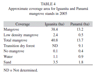
</span></font><br  style="font-family: verdana;"> <font size="2"></font><br style="font-family: verdana;"> <font size="2"><span style="font-family: verdana;"><span  style="font-weight: bold;">Mapping:</span>Image georeferencing error was RMS= 12.1m for Iguanita and RMS=0.65m for Playa Panama. Variation between locations was due to higher number of field control points for Panama than for Iguanita. Initial estimation of stand length and width yielded approximate distances of 950m x 500 m for Iguanita, and 940m x 330m for Panama. Approximate area of mangrove forest (including both high and low mangrove forest density categories) was 13.7ha at Panama, and 40.8ha at Iguanita (<a href="#tab_4">Table 4</a>).    <br>     <br> </span></font>     <div style="text-align: center;"><font size="2"><a name="tab_4"></a><img      alt="" src="/img/revistas/rbt/v60s2/a07t4.gif"     ]]></body>
<body><![CDATA[ style="width: 305px; height: 239px;"><span      style="font-family: verdana;"></span></font><br      style="font-family: verdana;">     <font size="2"><span style="font-family: verdana;"></span></font></div>     <br style="font-family: verdana;">     <font size="2"><span style="font-family: verdana;">Panama stand is     mostly composed of     dense mangrove forest (51% of total     study area) or dry forest species (35% of total study area). Small     areas had dry soil and scarce mangrove trees (2%), as those with no     ]]></body>
<body><![CDATA[vegetation or covered by water or sand (12%). At Iguanita 84% of the     total study area corresponded to dense mangrove forest, 5% had only     scarce mangrove trees and 10% of the area had no vegetation or was     covered by sand or water (<a href="#tab_4">Table 4</a>, <a      href="/img/revistas/rbt/v60s2/a07i1.jpg">Figure 1</a> &amp; <a      href="/img/revistas/rbt/v60s2/a07i2.jpg">2</a>). In this case it     was not possible to classify the vegetation into mangrove or transition     to dry forest, as field data detail did not allow it.</span></font><br      style="font-family: verdana;">     <font size="2"></font><br style="font-family: verdana;">     ]]></body>
<body><![CDATA[<font style="font-weight: bold;" size="3"><span      style="font-family: verdana;">Discussion</span></font><br      style="font-family: verdana;">     <font size="2"></font><br style="font-family: verdana;">     <font size="2"><span style="font-family: verdana;">Previous mangrove     research in the     north Pacific of Costa Rica has     focused mainly on the mangrove stands of Puerto Soley and Santa Rosa,     located further North along the coast, with three studies at each site     (Zamora-Trejos &amp; Cortes 2009). The Panama stand had only been     ]]></body>
<body><![CDATA[considered in a study related to a species of crab (<span      style="font-style: italic;">Ucides     occidentalis</span>), where forest structure information was limited to     mentioning the presence of three mangrove genera (Cabrera- Pena <span      style="font-style: italic;">et al.</span>     1994). Although we present a preliminary analysis and field     observations of the Iguanita stand - given logistical difficulties in     the field - these findings are relevant given that there are no     previous publications of this stand other than a general species list     (Cordoba-Munoz <span style="font-style: italic;">et al.</span> 1998).     ]]></body>
<body><![CDATA[Results provided by the present study of     Iguanita can be used to carry out further related research in this     stand and comparisons with more extensive analyses.</span></font><br      style="font-family: verdana;">     <font size="2"></font><br style="font-family: verdana;">     <font size="2"><span style="font-family: verdana;">All mangrove species     encountered in     this study have been previously     reported for the mangrove vegetation of the North Pacific region of     Costa Rica (Soto &amp; Jimenez 1982, Jimenez &amp; Soto 1985, Jimenez     ]]></body>
<body><![CDATA[1994). The higher number of species encountered at Panama (five) in     relation to Iguanita (three), might be due to a more heterogeneous     environment within the Panama stand from hydrodynamic variations     resulting in very arid areas, and more homogenous inundation at     Iguanita. However, further study of Iguanita is needed before the     presence of other species is discarded. At Panama, <span      style="font-style: italic;">Rhizophora,     Avicennia, </span>and<span style="font-style: italic;"> Laguncularia</span>     had been previously reported by     Cabrera-Pena <span style="font-style: italic;">et al.</span> (1994),     ]]></body>
<body><![CDATA[while <span style="font-style: italic;">C. eructus</span> is a new     report for the     stand. At Iguanita, previous reported species also included <span      style="font-style: italic;">C. erectus</span>,     Rhizophora racemosa (Cordoba-Munoz <span style="font-style: italic;">et     al.</span> 1998) (neither encountered in     this study), and <span style="font-style: italic;">A. bicolor</span>     (Cordoba-Munoz <span style="font-style: italic;">et al.</span> 1998)     (of which only     one tree was encountered, located outside of the randomly selected     ]]></body>
<body><![CDATA[transects). Variation in species previously reported and those found in     this study indicates that further analysis of the Iguanita stand is     needed before a definite species listing can be established.</span></font><br      style="font-family: verdana;">     <font size="2"></font><br style="font-family: verdana;">     <font size="2"><span style="font-family: verdana;"><span      style="font-style: italic;">Rhizophora     harrisonii</span> and     <span style="font-style: italic;">Pelliciera rhizophorae</span> were     not encountered     ]]></body>
<body><![CDATA[at either Panama or Iguanita, contrary to their reported presence in     nearby mangrove stands - R. harrisonii at Puerto Soley (Soto &amp;     Jimenez 1982) and Tamarindo (Pizarro &amp; Angulo 1993); and <span      style="font-style: italic;">P.     rhizophorae</span> in Potrero Grande (Cordoba- Munoz <span      style="font-style: italic;">et al.</span> 1998), Tamarindo     (Pizarro &amp; Angulo 1993), and Tempisque (Jimenez &amp; Soto 1985).     However, <span style="font-style: italic;">P. rhizophorae</span> is     rarely encountered in high salinity mangrove     stands such as those present in the north Pacific coast (Jimenez &amp;     ]]></body>
<body><![CDATA[Soto 1985). On the other hand, <span style="font-style: italic;">R.     harrisonii </span>might be a hybrid of<span style="font-style: italic;">     R.     mangle </span>and<span style="font-style: italic;"> R. racemosa</span>,     and accurate species identification in the     field may be challenging (Duke <span style="font-style: italic;">et al.</span>     2002). Further detailed study of     Rhizophora at both stands, including reproductive morphology and     phenology, should be carried out to elucidate species variation.</span></font><br      style="font-family: verdana;">     ]]></body>
<body><![CDATA[<font size="2"></font><br style="font-family: verdana;">     <font size="2"><span style="font-family: verdana;">The complexity index     (CI) is a tool     for quantitatively comparing forest     structural complexity (Pool <span style="font-style: italic;">et al.</span>     1977) which varied between both     stands, Iguanita had much higher complexity (CI=86.5) than Panama     (CI=1.1). Furthermore, Panama CI is also lower than those reported for     Santa Rosa (CI=4.9) (Pool <span style="font-style: italic;">et al.</span>     1977), and Puerto Soley (CI=17.3)     ]]></body>
<body><![CDATA[(Jimenez &amp; Soto 1985), which are the closest studied mangrove areas     (further North). Even with data limited to the preliminary analysis,     Iguanita is more complex than most mangroves in the area and has values     closer to mangrove stands further south (with higher precipitation     rates) such as: Tamarindo (CI=30.7), Pochote (CI=30.7), Quepos     (CI=65.3), and Sierpe (CI=54.3, the most developed stand in the Pacific     of Costa Rica given significantly increased precipitation rates)     (Jimenez &amp; Soto 1985). Furthermore, including the three additional     species reported for Iguanita, but not encountered within transects     during this study, would further increase CI to 173.0. Therefore,     ]]></body>
<body><![CDATA[complete species listings of the entire mangrove stands, not just     randomly selected sections, need to be fully developed and a broader     study of Iguanita carried out before final CI comparisons can be made.     Moreover, the different methodologies used for studying the stands     (PCQM used in this study vs. parcel and transect methods used in     previous studies) may have an impact on results and could affect     comparisons among stands (Cintron &amp; Schaeffer-Novelli 1984).</span></font><br      style="font-family: verdana;">     <font size="2"></font><br style="font-family: verdana;">     <font size="2"><span style="font-family: verdana;">Overall, mangrove     ]]></body>
<body><![CDATA[species zonation     followed a similar pattern at both     stands, and coincides with previous reports in Costa Rica, with     <span style="font-style: italic;">Avicennia</span> species being more     tolerant to dry hypersaline conditions,     and <span style="font-style: italic;">Rhizophora</span> abundant near     hydrated unconsolidated soil and water     channels (Soto &amp; Jimenez 1982, Jimenez &amp; Soto 1985, Jimenez     1994). Species variation seemed related to freshwater influence     (salinity variation) and inundation patterns. Dwarf <span     ]]></body>
<body><![CDATA[ style="font-style: italic;">Avicennia</span> trees, as     observed in both stands, have been previously encountered in very dry     areas further north (Puerto Soley), where marked seasonal precipitation     and lack of tidal flooding for weeks to months leads to increased     interstitial salinity, corresponding with decreased tree height, basal     area and leaf size (Soto &amp; Jimenez 1982, Soto &amp; Corrales 1987).     Salinities encountered during this study at Iguanita were not as high     as those at Puerto Soley (163psu in dryer areas) (Soto &amp; Jimenez     1982). However, only humid areas at Iguanita were sampled given limited     interstitial water availability. Water shortage frequently coincided     ]]></body>
<body><![CDATA[with areas dominated by <span style="font-style: italic;">Avicennia</span>     and unvegetated salt crusts, which     might indicate much higher interstitial water salinities (at greater     soil depths than were sampled in this study) as it has been reported     that above 60psu <span style="font-style: italic;">Avicennia</span> is     the dominant mangrove (Jimenez 1994).     Further study of the interstitial water salinity gradient, fresh water     input, tidal range and seasonal variations need to be carried out at     both stands.</span></font><br style="font-family: verdana;">     <font size="2"></font><br style="font-family: verdana;">     ]]></body>
<body><![CDATA[<font size="2"><span style="font-family: verdana;">Densities at both     stands (Iguanita=     67.2 and Panama= 8.4stems/0.1ha)     were lower than those reported for Puerto Soley (170.8stems/0.1ha)     (Soto &amp; Jimenez 1982), and Santa Rosa (105stems/0.1ha) (Pool <span      style="font-style: italic;">et al.</span>     1977). This might be related to lower tree height in stands further     North due to diminished precipitation, allowing higher densities </span></font><font      size="2"><span style="font-family: verdana;">in shorter forests.     Although,     ]]></body>
<body><![CDATA[higher densities were also found in     Barranca (central </span></font><font size="2"><span      style="font-family: verdana;">Pacific) (110stems/0.1ha) a stand     dominated by <span style="font-style: italic;">P. rhizophorae</span>.     Comparing overall stand density among differing species dominance might     not be adequate, as well as comparison based on different sampling     techniques. A mangrove stand in Osa (south Pacific coast) dominated by     <span style="font-style: italic;">R. mangle</span> with mean height of     34m presented a density of 36stems/0.1ha     (Pool <span style="font-style: italic;">et al.</span> 1977), which is     ]]></body>
<body><![CDATA[intermediate between Iguanita and Panama,     highlighting the great difference encountered between both mangroves     within the same bay (Bahia Culebra) and climate.</span></font><br      style="font-family: verdana;">     <font size="2"></font><br style="font-family: verdana;">     <font size="2"><span style="font-family: verdana;">Lower total     densities in Panama in     relation to Iguanita could be     indicative of a more mature mangrove stand, as it is considered that as     a mangrove forest matures density </span></font><font size="2"><span     ]]></body>
<body><![CDATA[ style="font-family: verdana;">decreases while tree diameter     increases (Cintron &amp;     Schaeffer-Novelli 1984). However, tree density and diameter comparisons     between both stands may not be appropriate given that preliminary     analysis of Iguanita showed dominance by <span      style="font-style: italic;">Rhizophora</span> within the sampled     area, and Panama was dominated by <span style="font-style: italic;">Avicennia</span>     (of which tree height and     diameter data was not comparable given critical variation in total     trees encountered). Furthermore, <span style="font-style: italic;">Rhizophora</span>     ]]></body>
<body><![CDATA[tree heights did not vary     between stands but diameters were higher at Iguanita, while     Laguncularia trees were taller at Iguanita but had similar diameters at     both stands. Nonetheless, basal area at both sites (Iguanita=25.1 &amp;     Panama= 2.7m<sup>2</sup>/0.1ha) was higher than at Santa Rosa (2.32m<sup>2</sup>/0.1ha)     (Pool     <span style="font-style: italic;">et al.</span> 1977), and Puerto Soley     (1.97m<sup>2</sup>/0.1ha), which may be due to     decreased tree height at this last location (Soto &amp; Jimenez 1982).     Mean and maximum <span style="font-style: italic;">Laguncularia</span>     ]]></body>
<body><![CDATA[heights at Panama coincide with those for     the North Pacific (12m) (Jimenez &amp; Soto 1985); yet they are much     higher at Iguanita (mean=21.2m; maximum=40.7m). Density variation     between studied stands may therefore be due to species density     variation (related to hydrodynamic differences) and not stand maturity.     Importance value (IV) for <span style="font-style: italic;">Avicennia</span>     </span></font><font size="2"><span style="font-family: verdana;">at     Panama (51%)     coincides with IV     for this species at Puerto Soley.     ]]></body>
<body><![CDATA[However, other important species at Puerto Soley were <span      style="font-style: italic;">R. mangle </span>and<span      style="font-style: italic;"> R.     harrisonii</span>, while at Panama they were <span      style="font-style: italic;">L. racemosa </span>and<span      style="font-style: italic;"> C. erectus</span>. This     seems to indicate a higher freshwater input at Panama, as Laguncularia     and Conocarpus are more abundant at lower salinities (Soto &amp;     Jimenez 1982). Furthermore, the tallest <span      style="font-style: italic;">A. germinans</span> at Puerto Soley     ]]></body>
<body><![CDATA[were 5m (Soto &amp; Jimenez 1982); while at Panama they were up to 25m     (maximum height of A. germinans was 25.5m, and 27.8m for <span      style="font-style: italic;">A. bicolor</span>).     Dominance by <span style="font-style: italic;">R. mangle</span> in the     area studied at Iguanita, does not     coincide with previously reported forest structure for the northern     Pacific of dry climate other than at Santa Rosa with Rhizophora being     68% dominant, yet with a lower mean height of 10m (Pool<span      style="font-style: italic;"> et. al.</span> 1977).     Meanwhile, maximum <span style="font-style: italic;">Rhizophora</span>     ]]></body>
<body><![CDATA[height at Puerto Soley was 19m (Soto     &amp; Jimenez 1982), 18m at Panama and much higher with 41m at Iguanita.</span></font><br      style="font-family: verdana;">     <font size="2"></font><br style="font-family: verdana;">     <font size="2"><span style="font-family: verdana;">The question remains     if comparisons     based on preliminary analysis of     Iguanita indicating marked forest structure variations between both     stands could be related to overall hydrodynamic characteristics of each     location, as higher and more frequent inundation at Iguanita, located     ]]></body>
<body><![CDATA[in the inner part of the Bay, may be leading to <span      style="font-style: italic;">Rhizophora</span> dominance.     North Pacific mangrove stands are considered to be fringe type     mangroves (Pool <span style="font-style: italic;">et al.</span> 1977,     Jimenez &amp; Soto 1985) of high salinity     and <span style="font-style: italic;">Avicennia</span> dominance     (Jimenez &amp; Soto 1985), which matched well     with the characteristics found at Panama. However, Iguanita could be     more of a riverine type stand, under intense water flow variations and     nutrient input, presenting high vegetative development (Cintron &amp;     ]]></body>
<body><![CDATA[Schaeffer- Novelli 1983) and canopy height (Pool <span      style="font-style: italic;">et al.</span> 1977). Given     the difference between both stands, with dominance of tall <span      style="font-style: italic;">Rhizophora</span>     trees at Iguanita, and tall <span style="font-style: italic;">Avicennia</span>     trees at Panama, Bahia Culebra     might be a particular transition area between the Central Pacific     mangroves (of higher precipitation) and those of more arid&nbsp; </span></font><font      size="2"><span style="font-family: verdana;">climates in the north     Pacific     ]]></body>
<body><![CDATA[region as defined by Jimenez &amp; Soto     (1985).</span></font><br style="font-family: verdana;">     <font size="2"></font><br style="font-family: verdana;">     <font size="2"><span style="font-family: verdana;">Mangrove stand area     estimates from     this study (40.8ha Iguanita &amp;     13.7ha Panama) are lower than previous reports of 100ha for Iguanita     (Cordoba-Munoz <span style="font-style: italic;">et al.</span> 1998)     and 60ha for Panama (Bravo &amp; Rivera     1998). However, the noted higher area at Iguanita in relation to Panama     ]]></body>
<body><![CDATA[is maintained. Estimated stand area in the present study was carried     out using field coordinates and observations, and defines mangrove area     as only containing dense or low density mangrove species. This     methodological approach may explain part of the difference in estimated     areas from previous reports. However, while it is still considered that     both stands have high mangrove vegetation, no doubt related to the     overall protection of mangrove forests in Costa Rica, they are still     under significant pressure due to tourist facility development and     associated negative impacts. Mangroves previously present at the nearby     Playas del Coco have now completely disappeared, most likely related to     ]]></body>
<body><![CDATA[large infrastructure development at this site (per. obs.). Historical     image analysis is needed to elucidate if there has been a reduction in     mangrove cover at Iguanita and Panama, and continued conservation of     these habitats is critical.</span></font><br      style="font-family: verdana;">     <font size="2"></font><br style="font-family: verdana;">     <font size="2"><span style="font-family: verdana;">Even though both     Iguanita and     Panama mangrove stands are within Culebra     Bay, structurally they are very different form one another and seem to     ]]></body>
<body><![CDATA[be under two different hydrodynamic contexts. Considering that global     mean sea level has risen approximately 1-2mm/ year over the last 100     years (Gornitz 1995, Domingues <span style="font-style: italic;">et al.</span>     2008) and climate change is     thought to generate continuous sea level rise in coming years (Titus     &amp; Narayanan 1995), increased inundation might result in mangrove     retreat near the shoreline and landward migration (Cohen &amp; Lara     2003). Unfortunately, both stands studied are limited inland by     geographical (increased land elevation), and anthropogenic (roads)     barriers that would prevent inward mangrove extension. For this reason,     ]]></body>
<body><![CDATA[the protection of buffer zones at the back of Costa Rican mangroves is     considered of great importance, to increase their chances of survival     and conservation. Furthermore, given the social, economic and     ecological importance of mangrove habitats, further studies at these     and other mangroves in the     country </span></font><font size="2"><span      style="font-family: verdana;">are urgently needed.</span></font><font      size="2"><span style="font-family: verdana;">     &nbsp;&nbsp;&nbsp;&nbsp;&nbsp;&nbsp;&nbsp;&nbsp;&nbsp;&nbsp;&nbsp;&nbsp;&nbsp;&nbsp;&nbsp;&nbsp;&nbsp;&nbsp;&nbsp;&nbsp;&nbsp;&nbsp;&nbsp;&nbsp;&nbsp;&nbsp;&nbsp;&nbsp;&nbsp;&nbsp;&nbsp;&nbsp;&nbsp;&nbsp;&nbsp;&nbsp;&nbsp;&nbsp;&nbsp;&nbsp;&nbsp;&nbsp;&nbsp;&nbsp;&nbsp;&nbsp;&nbsp;&nbsp;&nbsp;&nbsp;&nbsp;&nbsp;&nbsp;&nbsp;&nbsp;&nbsp;&nbsp;&nbsp;&nbsp;&nbsp;&nbsp;&nbsp;&nbsp;&nbsp;&nbsp;&nbsp;&nbsp;&nbsp;&nbsp;&nbsp;&nbsp;&nbsp;&nbsp;&nbsp;&nbsp;&nbsp;&nbsp;&nbsp;&nbsp;&nbsp;&nbsp;&nbsp;&nbsp;&nbsp;&nbsp;&nbsp;&nbsp;&nbsp;&nbsp;&nbsp;&nbsp;&nbsp;&nbsp;&nbsp;&nbsp;&nbsp;&nbsp;&nbsp;&nbsp;&nbsp;&nbsp;&nbsp;&nbsp;&nbsp;&nbsp;&nbsp;&nbsp;&nbsp;&nbsp;&nbsp;&nbsp;&nbsp;&nbsp;&nbsp;&nbsp;&nbsp;&nbsp;&nbsp;&nbsp;&nbsp;&nbsp;&nbsp;&nbsp;&nbsp;&nbsp;&nbsp;&nbsp;&nbsp;&nbsp;&nbsp;&nbsp;&nbsp;&nbsp;&nbsp;&nbsp;&nbsp;&nbsp;&nbsp;&nbsp;&nbsp;&nbsp;&nbsp;&nbsp;&nbsp;&nbsp;&nbsp;&nbsp;&nbsp;&nbsp;&nbsp;&nbsp;&nbsp;&nbsp;&nbsp;&nbsp;&nbsp;     </span></font><br style="font-family: verdana;">     ]]></body>
<body><![CDATA[<font size="2"></font><br      style="font-family: verdana; font-weight: bold;">     <font style="font-weight: bold;" size="3"><span      style="font-family: verdana;">Acknowledgments</span></font><br      style="font-family: verdana;">     <font size="2"></font><br style="font-family: verdana;">     <font size="2"><span style="font-family: verdana;">This project was     funded by     Ecodesarrollo Papagayo and by the     Vicerrectoria de Investigacion and CIMAR at the Universidad de Costa     ]]></body>
<body><![CDATA[Rica. We thank the Escuela de Biologia, Universidad de Costa Rica, for     equipment loaned. We would like to thank J.A. Sibaja-Cordero for his     help with statistical analysis, all those who helped in the field, and     three anonymous reviewers whose comments greatly improved this     manuscript.</span></font><br style="font-family: verdana;">     <font style="font-weight: bold;" size="3"><span      style="font-family: verdana;"></span></font>     <hr style="width: 100%; height: 2px;"><font style="font-weight: bold;"      size="3"><span style="font-family: verdana;">References</span></font><br      style="font-family: verdana; font-weight: bold;">     ]]></body>
<body><![CDATA[<font style="font-weight: bold;" size="2"></font><br      style="font-family: verdana;">     <font size="2"><span style="font-family: verdana;">Alfaro, E.J., J.     Cortes, J.J.     Alvarado, C. Jimenez, A. Leon, C.     Sanchez-Noguera, J. Nivia-Ruiz &amp; E. Ruiz- Campos. 2012. Clima y     variabilidad climatica de la temperatura subsuperfical del mar en Bahia     Culebra, Guanacaste, Costa Rica. Rev. Biol. Trop. 60 (Suppl. 2):     <!-- ref -->159-171.    &nbsp;&nbsp;&nbsp;&nbsp;&nbsp;&nbsp;&nbsp;&nbsp;[&#160;<a href="javascript:void(0);" onclick="javascript: window.open('/scielo.php?script=sci_nlinks&ref=1444151&pid=S0034-7744201200060000700001&lng=','','width=640,height=500,resizable=yes,scrollbars=1,menubar=yes,');">Links</a>&#160;]<!-- end-ref --><!-- ref --></span></font><br style="font-family: verdana;"> <font size="2"></font><br style="font-family: verdana;"> <font size="2"><span style="font-family: verdana;">Bravo, J. &amp; L. Rivera. 1998. Mapas de Humedales de Costa Rica e Informacion Complementaria. SINAC, MINAE&#8211;UICN, San Jose, Costa Rica. Escala 1:200 000.    &nbsp;&nbsp;&nbsp;&nbsp;&nbsp;&nbsp;&nbsp;&nbsp;[&#160;<a href="javascript:void(0);" onclick="javascript: window.open('/scielo.php?script=sci_nlinks&ref=1444152&pid=S0034-7744201200060000700002&lng=','','width=640,height=500,resizable=yes,scrollbars=1,menubar=yes,');">Links</a>&#160;]<!-- end-ref --><!-- ref --></span></font><br style="font-family: verdana;"> <font size="2"></font><br style="font-family: verdana;"> <font size="2"><span style="font-family: verdana;">Cabrera-Pena, J., F. Vives-Jimenez &amp; Y. Solano-Lopez. 1994. Tamanos y proporcion sexual de <span style="font-style: italic;">Ucides occidentalis</span> (Crustacea: Gecarcinidae) en un manglar de Costa Rica. Uniciencia 11: 97-99.    &nbsp;&nbsp;&nbsp;&nbsp;&nbsp;&nbsp;&nbsp;&nbsp;[&#160;<a href="javascript:void(0);" onclick="javascript: window.open('/scielo.php?script=sci_nlinks&ref=1444153&pid=S0034-7744201200060000700003&lng=','','width=640,height=500,resizable=yes,scrollbars=1,menubar=yes,');">Links</a>&#160;]<!-- end-ref --><!-- ref --></span></font><br  style="font-family: verdana;"> <font size="2"></font><br style="font-family: verdana;"> <font size="2"><span style="font-family: verdana;">Cintron, G. &amp; Y. Schaeffer-Novelli. 1983. Introduccion a la ecologia del manglar. UNESCO, Montevideo, Uruguay.    &nbsp;&nbsp;&nbsp;&nbsp;&nbsp;&nbsp;&nbsp;&nbsp;[&#160;<a href="javascript:void(0);" onclick="javascript: window.open('/scielo.php?script=sci_nlinks&ref=1444154&pid=S0034-7744201200060000700004&lng=','','width=640,height=500,resizable=yes,scrollbars=1,menubar=yes,');">Links</a>&#160;]<!-- end-ref --><!-- ref --></span></font><br  style="font-family: verdana;"> <font size="2"></font><br style="font-family: verdana;"> <font size="2"><span style="font-family: verdana;">Cintron, G. &amp; Y. Schaeffer-Novelli. 1984. Methods for studying mangrove structure, p. 91-113. <span style="font-style: italic;">In</span>: S.C. Snedaker &amp; J.G. Snedaker (eds.). The Mangrove Ecosystem: Research Methods. UNESCO, Paris.    &nbsp;&nbsp;&nbsp;&nbsp;&nbsp;&nbsp;&nbsp;&nbsp;[&#160;<a href="javascript:void(0);" onclick="javascript: window.open('/scielo.php?script=sci_nlinks&ref=1444155&pid=S0034-7744201200060000700005&lng=','','width=640,height=500,resizable=yes,scrollbars=1,menubar=yes,');">Links</a>&#160;]<!-- end-ref --><!-- ref --></span></font><br  style="font-family: verdana;"> <font size="2"></font><br style="font-family: verdana;"> <font size="2"><span style="font-family: verdana;">Cohen C.M.L. &amp; R.J. Lara. 2003. Temporal changes of mangrove vegetation boundaries in Amazonia: Application of GIS and remote sensing. Wetlands Ecol. Manag. 11: 223-231.    &nbsp;&nbsp;&nbsp;&nbsp;&nbsp;&nbsp;&nbsp;&nbsp;[&#160;<a href="javascript:void(0);" onclick="javascript: window.open('/scielo.php?script=sci_nlinks&ref=1444156&pid=S0034-7744201200060000700006&lng=','','width=640,height=500,resizable=yes,scrollbars=1,menubar=yes,');">Links</a>&#160;]<!-- end-ref --><!-- ref --></span></font><br  style="font-family: verdana;"> <font size="2"></font><br style="font-family: verdana;"> <font size="2"><span style="font-family: verdana;">Cordoba-Munoz, R., J.C. Romero-Araya &amp; N.J. Windevoxhel- Lora. 1998. Inventario de los humedales de Costa Rica. UICN, MINAE, SINAC, Embajada Real de los Paises Bajos, San Jose, Costa Rica.    &nbsp;&nbsp;&nbsp;&nbsp;&nbsp;&nbsp;&nbsp;&nbsp;[&#160;<a href="javascript:void(0);" onclick="javascript: window.open('/scielo.php?script=sci_nlinks&ref=1444157&pid=S0034-7744201200060000700007&lng=','','width=640,height=500,resizable=yes,scrollbars=1,menubar=yes,');">Links</a>&#160;]<!-- end-ref --><!-- ref --></span></font><br  style="font-family: verdana;"> <font size="2"></font><br style="font-family: verdana;"> <font size="2"><span style="font-family: verdana;">Cortes, J. &amp; I.S. Wehrtmann. 2009. Diversity of marine habitats of the Caribbean and Pacific of Costa Rica, p. 1-45. In I.S. Wehrtmann &amp; J. Cortes (Eds.). Marine Biodiversity of Costa Rica, Central America. Springer + Business Media, Berlin, Germany.    &nbsp;&nbsp;&nbsp;&nbsp;&nbsp;&nbsp;&nbsp;&nbsp;[&#160;<a href="javascript:void(0);" onclick="javascript: window.open('/scielo.php?script=sci_nlinks&ref=1444158&pid=S0034-7744201200060000700008&lng=','','width=640,height=500,resizable=yes,scrollbars=1,menubar=yes,');">Links</a>&#160;]<!-- end-ref --><!-- ref --></span></font><br  style="font-family: verdana;"> <font size="2"></font><br style="font-family: verdana;"> <font size="2"><span style="font-family: verdana;">Domingues, C.M., J.A. Church, N.J. White, P.J. Gleckler, S.E. Wijffels, P.M. Barrer &amp; J.R. Dunn. 2008. Improved estimates of upper-ocean warming and multidecadal sea-level rise. Nature 453: 1090-1093.    &nbsp;&nbsp;&nbsp;&nbsp;&nbsp;&nbsp;&nbsp;&nbsp;[&#160;<a href="javascript:void(0);" onclick="javascript: window.open('/scielo.php?script=sci_nlinks&ref=1444159&pid=S0034-7744201200060000700009&lng=','','width=640,height=500,resizable=yes,scrollbars=1,menubar=yes,');">Links</a>&#160;]<!-- end-ref --><!-- ref --></span></font><br  style="font-family: verdana;"> <font size="2"></font><br style="font-family: verdana;"> <font size="2"><span style="font-family: verdana;">Duke, N.C., E. Yuk Ying Lo &amp; M. Sun. 2002. Global distribution and genetic discontinuities of mangroves - emerging patterns in the evolution of <span style="font-style: italic;">Rhizophora</span>. Trees 16: 65-79.    &nbsp;&nbsp;&nbsp;&nbsp;&nbsp;&nbsp;&nbsp;&nbsp;[&#160;<a href="javascript:void(0);" onclick="javascript: window.open('/scielo.php?script=sci_nlinks&ref=1444160&pid=S0034-7744201200060000700010&lng=','','width=640,height=500,resizable=yes,scrollbars=1,menubar=yes,');">Links</a>&#160;]<!-- end-ref --><!-- ref --></span></font><br style="font-family: verdana;"> <font size="2"></font><br style="font-family: verdana;"> <font size="2"><span style="font-family: verdana;">Feller, I.C., C.E. Lovelock, U. Berger, K.L. McKee, S.B. Joye &amp; M.C. Ball. 2010. Biocomplexity in mangrove ecosystems. Annu. Rev. Mar. Sci. 2: 395-417.    &nbsp;&nbsp;&nbsp;&nbsp;&nbsp;&nbsp;&nbsp;&nbsp;[&#160;<a href="javascript:void(0);" onclick="javascript: window.open('/scielo.php?script=sci_nlinks&ref=1444161&pid=S0034-7744201200060000700011&lng=','','width=640,height=500,resizable=yes,scrollbars=1,menubar=yes,');">Links</a>&#160;]<!-- end-ref --><!-- ref --></span></font><br style="font-family: verdana;"> <font size="2"></font><br style="font-family: verdana;"> <font size="2"><span style="font-family: verdana;">Gornitz, V. 1995. Sea-level RSC: a review of recent past and near future trends. Earth Surf. Proc. Land. 20: 7-20.    &nbsp;&nbsp;&nbsp;&nbsp;&nbsp;&nbsp;&nbsp;&nbsp;[&#160;<a href="javascript:void(0);" onclick="javascript: window.open('/scielo.php?script=sci_nlinks&ref=1444162&pid=S0034-7744201200060000700012&lng=','','width=640,height=500,resizable=yes,scrollbars=1,menubar=yes,');">Links</a>&#160;]<!-- end-ref --><!-- ref --></span></font><br  style="font-family: verdana;"> <font size="2"></font><br style="font-family: verdana;"> <font size="2"><span style="font-family: verdana;">Hammer, O., D.A.T. Harper &amp; P. Ryan. 2001. PAST: Paleontological Statistics software package for education and data analysis (Version 2.01. May 2010). Palaentol. Electr. 4: 1-9.    &nbsp;&nbsp;&nbsp;&nbsp;&nbsp;&nbsp;&nbsp;&nbsp;[&#160;<a href="javascript:void(0);" onclick="javascript: window.open('/scielo.php?script=sci_nlinks&ref=1444163&pid=S0034-7744201200060000700013&lng=','','width=640,height=500,resizable=yes,scrollbars=1,menubar=yes,');">Links</a>&#160;]<!-- end-ref --><!-- ref --></span></font><br  style="font-family: verdana;"> <font size="2"></font><br style="font-family: verdana;"> <font size="2"><span style="font-family: verdana;">Hogarth, P.J. 1999. The Biology of Mangroves. Oxford University Press, Oxford and New York.    &nbsp;&nbsp;&nbsp;&nbsp;&nbsp;&nbsp;&nbsp;&nbsp;[&#160;<a href="javascript:void(0);" onclick="javascript: window.open('/scielo.php?script=sci_nlinks&ref=1444164&pid=S0034-7744201200060000700014&lng=','','width=640,height=500,resizable=yes,scrollbars=1,menubar=yes,');">Links</a>&#160;]<!-- end-ref --><!-- ref --></span></font><br style="font-family: verdana;"> <font size="2"></font><br style="font-family: verdana;"> <font size="2"><span style="font-family: verdana;">IGNCR. 1988. Hoja cartografica Carrillo Norte 3047 I. Instituto Geografico de Costa Rica, Ministerio de Transportes, San Jose, Costa Rica. Edicion 3-IGNCR. Escala 1: 50 000.    &nbsp;&nbsp;&nbsp;&nbsp;&nbsp;&nbsp;&nbsp;&nbsp;[&#160;<a href="javascript:void(0);" onclick="javascript: window.open('/scielo.php?script=sci_nlinks&ref=1444165&pid=S0034-7744201200060000700015&lng=','','width=640,height=500,resizable=yes,scrollbars=1,menubar=yes,');">Links</a>&#160;]<!-- end-ref --><!-- ref --></span></font><br  style="font-family: verdana;"> <font size="2"></font><br style="font-family: verdana;"> <font size="2"><span style="font-family: verdana;">ITCR. 2004. Road Layer, Digital Atlas of Costa Rica. Lambert Conformal Conic Proyection, Ocotepeque Fundamental Datum. 1:200 000. Instituto Tecnologico de Costa Rica. Cartago, Costa Rica.    &nbsp;&nbsp;&nbsp;&nbsp;&nbsp;&nbsp;&nbsp;&nbsp;[&#160;<a href="javascript:void(0);" onclick="javascript: window.open('/scielo.php?script=sci_nlinks&ref=1444166&pid=S0034-7744201200060000700016&lng=','','width=640,height=500,resizable=yes,scrollbars=1,menubar=yes,');">Links</a>&#160;]<!-- end-ref --><!-- ref --></span></font><br  style="font-family: verdana;"> <font size="2"></font><br style="font-family: verdana;"> <font size="2"><span style="font-family: verdana;">Jimenez, J.A. 1994. Los manglares del Pacifico Centroamericano. EFUNA, Heredia, Costa Rica.    &nbsp;&nbsp;&nbsp;&nbsp;&nbsp;&nbsp;&nbsp;&nbsp;[&#160;<a href="javascript:void(0);" onclick="javascript: window.open('/scielo.php?script=sci_nlinks&ref=1444167&pid=S0034-7744201200060000700017&lng=','','width=640,height=500,resizable=yes,scrollbars=1,menubar=yes,');">Links</a>&#160;]<!-- end-ref --><!-- ref --></span></font><br style="font-family: verdana;"> <font size="2"></font><br style="font-family: verdana;"> <font size="2"><span style="font-family: verdana;">Jim&eacute;nez, J.A. &amp; R. Soto. 1985. Patrones regionales en la estructura y composici&oacute;n flor&iacute;stica de los manglares de la Costa Pac&iacute;fica de Costa Rica. Rev. Biol. Trop. 33: 25-37.    &nbsp;&nbsp;&nbsp;&nbsp;&nbsp;&nbsp;&nbsp;&nbsp;[&#160;<a href="javascript:void(0);" onclick="javascript: window.open('/scielo.php?script=sci_nlinks&ref=1444168&pid=S0034-7744201200060000700018&lng=','','width=640,height=500,resizable=yes,scrollbars=1,menubar=yes,');">Links</a>&#160;]<!-- end-ref --><!-- ref --></span></font><br  style="font-family: verdana;"> <font size="2"></font><br style="font-family: verdana;"> <font size="2"><span style="font-family: verdana;">Kathiresan, K. &amp; S.Z. Qasim. 2005. Biodiversity of Mangrove Ecosystems. Hindustan Publ., New Delhi, India.    &nbsp;&nbsp;&nbsp;&nbsp;&nbsp;&nbsp;&nbsp;&nbsp;[&#160;<a href="javascript:void(0);" onclick="javascript: window.open('/scielo.php?script=sci_nlinks&ref=1444169&pid=S0034-7744201200060000700019&lng=','','width=640,height=500,resizable=yes,scrollbars=1,menubar=yes,');">Links</a>&#160;]<!-- end-ref --><br>     <!-- ref --><br> Pizarro, F. &amp; H. Angulo. 1993. Diagnostico de los manglares de la costa Pac&iacute;fica de Costa Rica: Informe para la Comisi&oacute;n Nacional de Manglares. UICN. San Jos&eacute;, Costa Rica.    &nbsp;&nbsp;&nbsp;&nbsp;&nbsp;&nbsp;&nbsp;&nbsp;[&#160;<a href="javascript:void(0);" onclick="javascript: window.open('/scielo.php?script=sci_nlinks&ref=1444171&pid=S0034-7744201200060000700020&lng=','','width=640,height=500,resizable=yes,scrollbars=1,menubar=yes,');">Links</a>&#160;]<!-- end-ref --><!-- ref --></span></font><br  style="font-family: verdana;"> <font size="2"></font><br style="font-family: verdana;"> <font size="2"><span style="font-family: verdana;">Pizarro, F., L. Piedra, J. Bravo, J. Asch &amp; C. Asch. 2004. Manual de procedimientos para el manejo de los manglares en Costa Rica. Grupo de Trabajo en Humedales- Costa Rica. Programa Nacional de Humedales. Editorial Fundaci&oacute;n UNA, Heredia, Costa Rica.    &nbsp;&nbsp;&nbsp;&nbsp;&nbsp;&nbsp;&nbsp;&nbsp;[&#160;<a href="javascript:void(0);" onclick="javascript: window.open('/scielo.php?script=sci_nlinks&ref=1444172&pid=S0034-7744201200060000700021&lng=','','width=640,height=500,resizable=yes,scrollbars=1,menubar=yes,');">Links</a>&#160;]<!-- end-ref --><!-- ref --></span></font><br  style="font-family: verdana;"> <font size="2"></font><br style="font-family: verdana;"> <font size="2"><span style="font-family: verdana;">Polania, J. 1993. Mangroves of Costa Rica. Part I, p. 129-137. <span style="font-style: italic;">In </span>L.D. Lacerda (Ed.), Conservation and Sustainable Utilization of Mangrove Forests in Latin America and Africa Regions. ITTO/ISME Project PD 114/90 (F), Okinawa, Japan.    &nbsp;&nbsp;&nbsp;&nbsp;&nbsp;&nbsp;&nbsp;&nbsp;[&#160;<a href="javascript:void(0);" onclick="javascript: window.open('/scielo.php?script=sci_nlinks&ref=1444173&pid=S0034-7744201200060000700022&lng=','','width=640,height=500,resizable=yes,scrollbars=1,menubar=yes,');">Links</a>&#160;]<!-- end-ref --><!-- ref --></span></font><br  style="font-family: verdana;"> <font size="2"></font><br style="font-family: verdana;"> <font size="2"><span style="font-family: verdana;">Pool, D.J., S.C. Snedaker &amp; A.E. Lugo. 1977. Structure of mangrove forests in Florida, Puerto Rico, M&eacute;xico and Costa Rica. Biotropica 9: 195-212.    &nbsp;&nbsp;&nbsp;&nbsp;&nbsp;&nbsp;&nbsp;&nbsp;[&#160;<a href="javascript:void(0);" onclick="javascript: window.open('/scielo.php?script=sci_nlinks&ref=1444174&pid=S0034-7744201200060000700023&lng=','','width=640,height=500,resizable=yes,scrollbars=1,menubar=yes,');">Links</a>&#160;]<!-- end-ref --><!-- ref --></span></font><br style="font-family: verdana;"> <font size="2"></font><br style="font-family: verdana;"> <font size="2"><span style="font-family: verdana;">Sifleet, S., L. Pendleton &amp; B.C. Murray. 2011. State of the Science on Coastal Blue Carbon. A Summary for Policy Makers. Nicholas Institute Report, Duke University. Durham, U.S.A.    &nbsp;&nbsp;&nbsp;&nbsp;&nbsp;&nbsp;&nbsp;&nbsp;[&#160;<a href="javascript:void(0);" onclick="javascript: window.open('/scielo.php?script=sci_nlinks&ref=1444175&pid=S0034-7744201200060000700024&lng=','','width=640,height=500,resizable=yes,scrollbars=1,menubar=yes,');">Links</a>&#160;]<!-- end-ref --><!-- ref --></span></font><br  style="font-family: verdana;"> <font size="2"></font><br style="font-family: verdana;"> <font size="2"><span style="font-family: verdana;">Soto, R. &amp; L.F. Corrales. 1987. Variaciones de algunas caracteristicas foliares de <span style="font-style: italic;">Avicennia germinans</span> (L.) L. en un gradiente climatico y de salinidad. Rev. Biol. Trop. 35: 245-256.    &nbsp;&nbsp;&nbsp;&nbsp;&nbsp;&nbsp;&nbsp;&nbsp;[&#160;<a href="javascript:void(0);" onclick="javascript: window.open('/scielo.php?script=sci_nlinks&ref=1444176&pid=S0034-7744201200060000700025&lng=','','width=640,height=500,resizable=yes,scrollbars=1,menubar=yes,');">Links</a>&#160;]<!-- end-ref --><!-- ref --></span></font><br  style="font-family: verdana;"> <font size="2"></font><br style="font-family: verdana;"> <font size="2"><span style="font-family: verdana;">Soto, R. &amp; J.A. Jimenez. 1982. Analisis fisionomico y estructural del manglar de Puerto Soley, La Cruz, Guanacaste, Costa Rica. Rev. Biol. Trop. 30: 161-168.    &nbsp;&nbsp;&nbsp;&nbsp;&nbsp;&nbsp;&nbsp;&nbsp;[&#160;<a href="javascript:void(0);" onclick="javascript: window.open('/scielo.php?script=sci_nlinks&ref=1444177&pid=S0034-7744201200060000700026&lng=','','width=640,height=500,resizable=yes,scrollbars=1,menubar=yes,');">Links</a>&#160;]<!-- end-ref --><!-- ref --></span></font><br style="font-family: verdana;"> <font size="2"></font><br style="font-family: verdana;"> <font size="2"><span style="font-family: verdana;">Spalding, M., M. Kainuma &amp; L. Collins. 2010. World Atlas of Mangroves. Earthscan. London, United Kingdom.    &nbsp;&nbsp;&nbsp;&nbsp;&nbsp;&nbsp;&nbsp;&nbsp;[&#160;<a href="javascript:void(0);" onclick="javascript: window.open('/scielo.php?script=sci_nlinks&ref=1444178&pid=S0034-7744201200060000700027&lng=','','width=640,height=500,resizable=yes,scrollbars=1,menubar=yes,');">Links</a>&#160;]<!-- end-ref --><!-- ref --> </span></font><br  style="font-family: verdana;"> <font size="2"></font><br style="font-family: verdana;"> <font size="2"><span style="font-family: verdana;">Titus, J.G. &amp; V.K. Narayanan. 1995. The Probability of Sea Level Rise. United States Environmental Protection Agency, Washington, DC, USA.    &nbsp;&nbsp;&nbsp;&nbsp;&nbsp;&nbsp;&nbsp;&nbsp;[&#160;<a href="javascript:void(0);" onclick="javascript: window.open('/scielo.php?script=sci_nlinks&ref=1444179&pid=S0034-7744201200060000700028&lng=','','width=640,height=500,resizable=yes,scrollbars=1,menubar=yes,');">Links</a>&#160;]<!-- end-ref --><!-- ref --></span></font><br style="font-family: verdana;"> <font size="2"></font><br style="font-family: verdana;"> <font size="2"><span style="font-family: verdana;">Valiela, I., J.L. Bowen &amp; J.K. York. 2001. Mangrove forests: one of the world/s threatened major tropical environments. BioScience 51: 807-815.    &nbsp;&nbsp;&nbsp;&nbsp;&nbsp;&nbsp;&nbsp;&nbsp;[&#160;<a href="javascript:void(0);" onclick="javascript: window.open('/scielo.php?script=sci_nlinks&ref=1444180&pid=S0034-7744201200060000700029&lng=','','width=640,height=500,resizable=yes,scrollbars=1,menubar=yes,');">Links</a>&#160;]<!-- end-ref --><!-- ref --></span></font><br style="font-family: verdana;"> <font size="2"></font><br style="font-family: verdana;"> <font size="2"><span style="font-family: verdana;">Zamora-Trejos, P. 2006. Manglares, p. 23-39. In: V. Nielsen- Mu&ntilde;oz &amp; M.A. Quesada-Alpizar (eds). Informe T&eacute;cnico Ambientes Marino Costeros de Costa Rica. Comisi&oacute;n Interdisciplinaria Marino Costera de la Zona Econ&oacute;mica Exclusiva de Costa Rica. CIMAR, CI, TNC, San Jos&eacute;, Costa Rica.    &nbsp;&nbsp;&nbsp;&nbsp;&nbsp;&nbsp;&nbsp;&nbsp;[&#160;<a href="javascript:void(0);" onclick="javascript: window.open('/scielo.php?script=sci_nlinks&ref=1444181&pid=S0034-7744201200060000700030&lng=','','width=640,height=500,resizable=yes,scrollbars=1,menubar=yes,');">Links</a>&#160;]<!-- end-ref --><!-- ref --></span></font><br  style="font-family: verdana;"> <font size="2"></font><br style="font-family: verdana;"> <font size="2"><span style="font-family: verdana;">Zamora-Trejos, P. &amp; J. Cortes. 2009. Los manglares de Costa Rica: el Pacifico Norte. Rev. Biol. Trop. 57: 473-488.    &nbsp;&nbsp;&nbsp;&nbsp;&nbsp;&nbsp;&nbsp;&nbsp;[&#160;<a href="javascript:void(0);" onclick="javascript: window.open('/scielo.php?script=sci_nlinks&ref=1444182&pid=S0034-7744201200060000700031&lng=','','width=640,height=500,resizable=yes,scrollbars=1,menubar=yes,');">Links</a>&#160;]<!-- end-ref --><!-- ref --></span></font><br  style="font-family: verdana;"> <font size="2"></font><br style="font-family: verdana;"> <font style="font-weight: bold;" size="2"><span  style="font-family: verdana;">Internet references</span></font><br  style="font-family: verdana;"> <font size="2"></font><br style="font-family: verdana;"> <font size="2"><span style="font-family: verdana;">ICT. 2010. Instituto Costarricense de Turismo. San Jos&eacute;, Costa Rica (accessed: 29 April 2010, <a  href="http://www.visitcostarica.com/ict">http://www.visitcostarica.com/ict</a>).    &nbsp;&nbsp;&nbsp;&nbsp;&nbsp;&nbsp;&nbsp;&nbsp;[&#160;<a href="javascript:void(0);" onclick="javascript: window.open('/scielo.php?script=sci_nlinks&ref=1444183&pid=S0034-7744201200060000700032&lng=','','width=640,height=500,resizable=yes,scrollbars=1,menubar=yes,');">Links</a>&#160;]<!-- end-ref --><!-- ref --><br> <br style="font-family: verdana;"> </span></font><font size="2"><span style="font-family: verdana;">IMN. 2010. Instituto Meteorol&oacute;gico Nacional de Costa Rica. International Airport Daniel Oduber Station in Liberia, Costa Rica (accessed: 29 April 2010, <a href="http://www.imn.ac.cr">http://www.imn.ac.cr</a>).    &nbsp;&nbsp;&nbsp;&nbsp;&nbsp;&nbsp;&nbsp;&nbsp;[&#160;<a href="javascript:void(0);" onclick="javascript: window.open('/scielo.php?script=sci_nlinks&ref=1444184&pid=S0034-7744201200060000700033&lng=','','width=640,height=500,resizable=yes,scrollbars=1,menubar=yes,');">Links</a>&#160;]<!-- end-ref --><!-- ref --></span></font><br  style="font-family: verdana;"> <font size="2"></font><br style="font-family: verdana;"> <font size="2"><span style="font-family: verdana;">SINAC 2010. Sistema Nacional de &Aacute;reas de Conservaci&oacute;n, Ministerio de Ambiente Energ&iacute;a y Telecomunicaciones. San Jos&eacute;, Costa Rica (accessed: 29 April 2010 <a href="http://www.sinac.go.cr">http://www.sinac.go.cr</a>).    &nbsp;&nbsp;&nbsp;&nbsp;&nbsp;&nbsp;&nbsp;&nbsp;[&#160;<a href="javascript:void(0);" onclick="javascript: window.open('/scielo.php?script=sci_nlinks&ref=1444185&pid=S0034-7744201200060000700034&lng=','','width=640,height=500,resizable=yes,scrollbars=1,menubar=yes,');">Links</a>&#160;]<!-- end-ref --><br>     <br> <a name="Correspondencia1"></a><a href="#Correspondencia2">*</a>Correspondencia a:    <br> </span></font><font size="2"><span style="font-family: verdana;">Jimena Samper-Villarreal. </span></font><font size="2"><span  style="font-family: verdana;">Centro de Investigaci&oacute;n en Ciencias del Mar y Limnolog&iacute;a (CIMAR), Ciudad de la Investigaci&oacute;n, Universidad de Costa Rica, San Pedro, 11501-2060 San Jos&eacute;, Costa Rica; <a href="mailto:jimena_samper@yahoo.com">jimena_samper@yahoo.com</a>.</span></font>    <br> <font size="2"><span style="font-family: verdana;">Jorge Cortes. </span></font><font size="2"><span  style="font-family: verdana;">Centro de Investigaci&oacute;n en Ciencias del Mar y Limnolog&iacute;a (CIMAR), Ciudad de la Investigaci&oacute;n, Universidad de Costa Rica, San Pedro, 11501-2060 San Jos&eacute;, Costa Rica; <a href="mailto:jorge.cortes@ucr.ac.cr">jorge.cortes@ucr.ac.cr</a>. </span></font><font size="2"><span style="font-family: verdana;">Escuela de Biolog&iacute;a, Universidad de Costa Rica, San Pedro, 11501-2060 San Jos&eacute;, Costa Rica.</span></font>    <br> <font size="2"><span style="font-family: verdana;">Catalina Benavides-Varela. </span></font><font size="2"><span  style="font-family: verdana;">Centro de Investigaci&oacute;n en Ciencias del Mar y Limnolog&iacute;a (CIMAR), Ciudad de la Investigaci&oacute;n, Universidad de Costa Rica, San Pedro, 11501-2060 San Jos&eacute;, Costa Rica; <a href="mailto:tabebuiaguayacan@gmail.com">tabebuiaguayacan@gmail.com</a>. </span></font><font size="2"><span style="font-family: verdana;">Escuela de Biolog&iacute;a, Universidad de Costa Rica, San Pedro, 11501-2060 San Jos&eacute;, Costa Rica.    <br> </span></font><font size="2"><span style="font-family: verdana;"><a  name="1"></a><a href="#3">1</a>. Centro de Investigaci&oacute;n en Ciencias del Mar y Limnolog&iacute;a (CIMAR), Ciudad de la Investigaci&oacute;n, Universidad de Costa Rica, San Pedro, 11501-2060 San Jos&eacute;, Costa Rica; <a href="mailto:jimena_samper@yahoo.com">jimena_samper@yahoo.com</a>; <a href="mailto:jorge.cortes@ucr.ac.cr">jorge.cortes@ucr.ac.cr</a>; <a href="mailto:tabebuiaguayacan@gmail.com">tabebuiaguayacan@gmail.com</a></span></font><br  style="font-family: verdana;"> <font size="2"><span style="font-family: verdana;"><a name="2"></a><a  href="#4">2</a>. Escuela de Biolog&iacute;a, Universidad de Costa Rica, San Pedro, 11501-2060 San Jos&eacute;, Costa Rica.</span></font><br  style="font-family: verdana;">     <div style="text-align: center;"><font style="font-weight: bold;"  size="2"><span style="font-family: verdana;"></span></font> <hr style="width: 100%; height: 2px;"><font style="font-weight: bold;"  size="2"><span style="font-family: verdana;">Received 28-VII-2011. Corrected 24-I-2012. Accepted 29-II-2012.</span></font><br  style="font-family: verdana;"> </div> </div>     ]]></body>
<body><![CDATA[ ]]></body><back>
<ref-list>
<ref id="B1">
<nlm-citation citation-type="journal">
<person-group person-group-type="author">
<name>
<surname><![CDATA[Alfaro]]></surname>
<given-names><![CDATA[E.J.]]></given-names>
</name>
<name>
<surname><![CDATA[Cortes]]></surname>
<given-names><![CDATA[J]]></given-names>
</name>
<name>
<surname><![CDATA[Alvarado]]></surname>
<given-names><![CDATA[J.J]]></given-names>
</name>
<name>
<surname><![CDATA[Jimenez]]></surname>
<given-names><![CDATA[C]]></given-names>
</name>
<name>
<surname><![CDATA[Leon]]></surname>
<given-names><![CDATA[A]]></given-names>
</name>
<name>
<surname><![CDATA[Sanchez-Noguera]]></surname>
<given-names><![CDATA[C]]></given-names>
</name>
<name>
<surname><![CDATA[Nivia-Ruiz]]></surname>
<given-names><![CDATA[J]]></given-names>
</name>
<name>
<surname><![CDATA[Ruiz- Campos.]]></surname>
<given-names><![CDATA[E]]></given-names>
</name>
</person-group>
<article-title xml:lang="es"><![CDATA[Clima y variabilidad climatica de la temperatura subsuperfical del mar en Bahia Culebra, Guanacaste, Costa Rica.]]></article-title>
<source><![CDATA[Rev. Biol. Trop.]]></source>
<year>2012</year>
<volume>60</volume>
<numero>^s2</numero>
<issue>^s2</issue>
<supplement>2</supplement>
<page-range>159-171.</page-range></nlm-citation>
</ref>
<ref id="B2">
<nlm-citation citation-type="book">
<person-group person-group-type="author">
<name>
<surname><![CDATA[Bravo]]></surname>
<given-names><![CDATA[J]]></given-names>
</name>
<name>
<surname><![CDATA[Rivera.]]></surname>
<given-names><![CDATA[L]]></given-names>
</name>
</person-group>
<source><![CDATA[Mapas de Humedales de Costa Rica e Informacion Complementaria.]]></source>
<year>1998</year>
<publisher-loc><![CDATA[San Jose ]]></publisher-loc>
<publisher-name><![CDATA[SINAC, MINAE&#8211;UICN]]></publisher-name>
</nlm-citation>
</ref>
<ref id="B3">
<nlm-citation citation-type="">
<person-group person-group-type="author">
<name>
<surname><![CDATA[Cabrera-Pena]]></surname>
<given-names><![CDATA[J.]]></given-names>
</name>
<name>
<surname><![CDATA[Vives-Jimenez]]></surname>
<given-names><![CDATA[F.]]></given-names>
</name>
<name>
<surname><![CDATA[Solano-Lopez.]]></surname>
<given-names><![CDATA[Y.]]></given-names>
</name>
</person-group>
<source><![CDATA[Tamanos y proporcion sexual de Ucides occidentalis (Crustacea: Gecarcinidae) en un manglar de Costa Rica.]]></source>
<year>1994</year>
<month>.</month>
<volume>11</volume>
<page-range>97-99.</page-range></nlm-citation>
</ref>
<ref id="B4">
<nlm-citation citation-type="book">
<person-group person-group-type="author">
<name>
<surname><![CDATA[Cintron]]></surname>
<given-names><![CDATA[G.]]></given-names>
</name>
<name>
<surname><![CDATA[Schaeffer-Novelli.]]></surname>
<given-names><![CDATA[Y.]]></given-names>
</name>
</person-group>
<source><![CDATA[Introduccion a la ecologia del manglar.]]></source>
<year>1983</year>
<publisher-loc><![CDATA[Montevideo ]]></publisher-loc>
<publisher-name><![CDATA[UNESCO]]></publisher-name>
</nlm-citation>
</ref>
<ref id="B5">
<nlm-citation citation-type="book">
<person-group person-group-type="author">
<name>
<surname><![CDATA[Cintron]]></surname>
<given-names><![CDATA[G.]]></given-names>
</name>
<name>
<surname><![CDATA[Schaeffer-Novelli]]></surname>
<given-names><![CDATA[Y.]]></given-names>
</name>
</person-group>
<article-title xml:lang="en"><![CDATA[Methods for studying mangrove structure]]></article-title>
<person-group person-group-type="editor">
<name>
<surname><![CDATA[Snedaker]]></surname>
<given-names><![CDATA[S.C.]]></given-names>
</name>
<name>
<surname><![CDATA[Snedaker]]></surname>
<given-names><![CDATA[J.G.]]></given-names>
</name>
</person-group>
<source><![CDATA[The Mangrove Ecosystem: Research Methods]]></source>
<year>1984</year>
<page-range>91-113</page-range><publisher-loc><![CDATA[^eParis Paris]]></publisher-loc>
<publisher-name><![CDATA[UNESCO]]></publisher-name>
</nlm-citation>
</ref>
<ref id="B6">
<nlm-citation citation-type="journal">
<person-group person-group-type="author">
<name>
<surname><![CDATA[Cohen]]></surname>
<given-names><![CDATA[C.M.L.]]></given-names>
</name>
<name>
<surname><![CDATA[Lara]]></surname>
<given-names><![CDATA[R.J.]]></given-names>
</name>
</person-group>
<source><![CDATA[Wetlands Ecol. Manag.]]></source>
<year></year>
<volume>11</volume>
<page-range>223-231</page-range></nlm-citation>
</ref>
<ref id="B7">
<nlm-citation citation-type="book">
<person-group person-group-type="author">
<name>
<surname><![CDATA[Cordoba-Munoz]]></surname>
<given-names><![CDATA[R.]]></given-names>
</name>
<name>
<surname><![CDATA[Romero-Araya]]></surname>
<given-names><![CDATA[J.C.]]></given-names>
</name>
<name>
<surname><![CDATA[Windevoxhel- Lora]]></surname>
<given-names><![CDATA[N.J.]]></given-names>
</name>
</person-group>
<source><![CDATA[Inventario de los humedales de Costa Rica.]]></source>
<year>1998</year>
<month>.</month>
<publisher-loc><![CDATA[San Jose ]]></publisher-loc>
<publisher-name><![CDATA[UICN, MINAE, SINAC, Embajada Real de los Paises Bajos]]></publisher-name>
</nlm-citation>
</ref>
<ref id="B8">
<nlm-citation citation-type="book">
<person-group person-group-type="author">
<name>
<surname><![CDATA[Cortes]]></surname>
<given-names><![CDATA[J.]]></given-names>
</name>
<name>
<surname><![CDATA[Wehrtmann]]></surname>
<given-names><![CDATA[I.S.]]></given-names>
</name>
</person-group>
<article-title xml:lang="en"><![CDATA[Diversity of marine habitats of the Caribbean and Pacific of Costa Rica]]></article-title>
<person-group person-group-type="editor">
<name>
<surname><![CDATA[Wehrtmann]]></surname>
<given-names><![CDATA[I.S.]]></given-names>
</name>
<name>
<surname><![CDATA[Cortes]]></surname>
<given-names><![CDATA[J.]]></given-names>
</name>
</person-group>
<source><![CDATA[Marine Biodiversity of Costa Rica, Central America.]]></source>
<year>2009</year>
<page-range>1-45</page-range><publisher-loc><![CDATA[^eBerlin Berlin]]></publisher-loc>
<publisher-name><![CDATA[Springer + Business Media]]></publisher-name>
</nlm-citation>
</ref>
<ref id="B9">
<nlm-citation citation-type="journal">
<person-group person-group-type="author">
<name>
<surname><![CDATA[Domingues]]></surname>
<given-names><![CDATA[C.M.]]></given-names>
</name>
<name>
<surname><![CDATA[Church]]></surname>
<given-names><![CDATA[J.A.]]></given-names>
</name>
<name>
<surname><![CDATA[White]]></surname>
<given-names><![CDATA[N.J.]]></given-names>
</name>
<name>
<surname><![CDATA[Gleckler]]></surname>
<given-names><![CDATA[P.J.]]></given-names>
</name>
<name>
<surname><![CDATA[Wijffels]]></surname>
<given-names><![CDATA[S.E.]]></given-names>
</name>
<name>
<surname><![CDATA[Barrer]]></surname>
<given-names><![CDATA[P.M.]]></given-names>
</name>
<name>
<surname><![CDATA[Dunn]]></surname>
<given-names><![CDATA[J.R.]]></given-names>
</name>
</person-group>
<article-title xml:lang="en"><![CDATA[Improved estimates of upper-ocean warming and multidecadal sea-level rise]]></article-title>
<source><![CDATA[Nature]]></source>
<year>2008</year>
<volume>453</volume>
<page-range>1090-1093</page-range></nlm-citation>
</ref>
<ref id="B10">
<nlm-citation citation-type="journal">
<person-group person-group-type="author">
<name>
<surname><![CDATA[Duke]]></surname>
<given-names><![CDATA[N.C.]]></given-names>
</name>
<name>
<surname><![CDATA[Yuk Ying Lo]]></surname>
<given-names><![CDATA[E.]]></given-names>
</name>
<name>
<surname><![CDATA[Sun]]></surname>
<given-names><![CDATA[M.]]></given-names>
</name>
</person-group>
<article-title xml:lang="en"><![CDATA[Global distribution and genetic discontinuities of mangroves - emerging patterns in the evolution of Rhizophora]]></article-title>
<source><![CDATA[Trees]]></source>
<year>2002</year>
<volume>16</volume>
<page-range>65-79</page-range></nlm-citation>
</ref>
<ref id="B11">
<nlm-citation citation-type="journal">
<person-group person-group-type="author">
<name>
<surname><![CDATA[Feller]]></surname>
<given-names><![CDATA[I.C.]]></given-names>
</name>
<name>
<surname><![CDATA[Lovelock]]></surname>
<given-names><![CDATA[C.E.]]></given-names>
</name>
<name>
<surname><![CDATA[Berger]]></surname>
<given-names><![CDATA[U.]]></given-names>
</name>
<name>
<surname><![CDATA[McKee]]></surname>
<given-names><![CDATA[K.L.]]></given-names>
</name>
<name>
<surname><![CDATA[Joye]]></surname>
<given-names><![CDATA[S.B.]]></given-names>
</name>
<name>
<surname><![CDATA[Ball]]></surname>
<given-names><![CDATA[M.C.]]></given-names>
</name>
</person-group>
<article-title xml:lang="en"><![CDATA[Biocomplexity in mangrove ecosystems]]></article-title>
<source><![CDATA[Annu. Rev. Mar. Sci.]]></source>
<year>2010</year>
<volume>2</volume>
<page-range>395-417</page-range></nlm-citation>
</ref>
<ref id="B12">
<nlm-citation citation-type="journal">
<person-group person-group-type="author">
<name>
<surname><![CDATA[Gornitz]]></surname>
<given-names><![CDATA[V.]]></given-names>
</name>
</person-group>
<article-title xml:lang="en"><![CDATA[Sea-level RSC: a review of recent past and near future trends]]></article-title>
<source><![CDATA[Earth Surf. Proc. Land.]]></source>
<year>1995</year>
<volume>20</volume>
<page-range>7-20</page-range></nlm-citation>
</ref>
<ref id="B13">
<nlm-citation citation-type="journal">
<person-group person-group-type="author">
<name>
<surname><![CDATA[Hammer]]></surname>
<given-names><![CDATA[O.]]></given-names>
</name>
<name>
<surname><![CDATA[Harper]]></surname>
<given-names><![CDATA[D.A.T.]]></given-names>
</name>
<name>
<surname><![CDATA[Ryan]]></surname>
<given-names><![CDATA[P.]]></given-names>
</name>
</person-group>
<article-title xml:lang="en"><![CDATA[PAST: Paleontological Statistics software package for education and data analysis (Version 2.01. May 2010)]]></article-title>
<source><![CDATA[Palaentol. Electr.]]></source>
<year>2001</year>
<volume>4</volume>
<page-range>1-9</page-range></nlm-citation>
</ref>
<ref id="B14">
<nlm-citation citation-type="book">
<person-group person-group-type="author">
<name>
<surname><![CDATA[Hogarth]]></surname>
<given-names><![CDATA[P.J.]]></given-names>
</name>
</person-group>
<source><![CDATA[The Biology of Mangroves]]></source>
<year>1999</year>
<publisher-loc><![CDATA[^eOxford^eNew York OxfordNew York]]></publisher-loc>
<publisher-name><![CDATA[Oxford University Press]]></publisher-name>
</nlm-citation>
</ref>
<ref id="B15">
<nlm-citation citation-type="book">
<collab>IGNCR.</collab>
<source><![CDATA[Hoja cartografica Carrillo Norte 3047 I: Instituto Geografico de Costa Rica, Ministerio de Transportes]]></source>
<year>1988</year>
<publisher-loc><![CDATA[San Jose ]]></publisher-loc>
<publisher-name><![CDATA[Edicion 3-IGNCR.]]></publisher-name>
</nlm-citation>
</ref>
<ref id="B16">
<nlm-citation citation-type="book">
<collab>ITCR.</collab>
<source><![CDATA[Road Layer, Digital Atlas of Costa Rica.: Lambert Conformal Conic Proyection, Ocotepeque Fundamental Datum.]]></source>
<year>2004</year>
<publisher-loc><![CDATA[Cartago ]]></publisher-loc>
<publisher-name><![CDATA[Instituto Tecnologico de Costa Rica.]]></publisher-name>
</nlm-citation>
</ref>
<ref id="B17">
<nlm-citation citation-type="book">
<person-group person-group-type="author">
<name>
<surname><![CDATA[Jimenez]]></surname>
<given-names><![CDATA[J.A.]]></given-names>
</name>
</person-group>
<source><![CDATA[Los manglares del Pacifico Centroamericano.]]></source>
<year>1994</year>
<publisher-loc><![CDATA[Heredia ]]></publisher-loc>
<publisher-name><![CDATA[EFUNA]]></publisher-name>
</nlm-citation>
</ref>
<ref id="B18">
<nlm-citation citation-type="journal">
<person-group person-group-type="author">
<name>
<surname><![CDATA[Jiménez]]></surname>
<given-names><![CDATA[J.A.]]></given-names>
</name>
<name>
<surname><![CDATA[Soto]]></surname>
<given-names><![CDATA[R.]]></given-names>
</name>
</person-group>
<article-title xml:lang="es"><![CDATA[Patrones regionales en la estructura y composición florística de los manglares de la Costa Pacífica de Costa Rica]]></article-title>
<source><![CDATA[Rev. Biol. Trop.]]></source>
<year>1985</year>
<volume>33</volume>
<page-range>25-37</page-range></nlm-citation>
</ref>
<ref id="B19">
<nlm-citation citation-type="book">
<person-group person-group-type="author">
<name>
<surname><![CDATA[Kathiresan]]></surname>
<given-names><![CDATA[K.]]></given-names>
</name>
<name>
<surname><![CDATA[Qasim]]></surname>
<given-names><![CDATA[S.Z.]]></given-names>
</name>
</person-group>
<source><![CDATA[Biodiversity of Mangrove Ecosystems]]></source>
<year>2005</year>
<publisher-loc><![CDATA[^eNew Delhi New Delhi]]></publisher-loc>
<publisher-name><![CDATA[Hindustan Publ.]]></publisher-name>
</nlm-citation>
</ref>
<ref id="B20">
<nlm-citation citation-type="book">
<person-group person-group-type="author">
<name>
<surname><![CDATA[Pizarro]]></surname>
<given-names><![CDATA[F.]]></given-names>
</name>
<name>
<surname><![CDATA[Angulo]]></surname>
<given-names><![CDATA[H.]]></given-names>
</name>
</person-group>
<source><![CDATA[Diagnostico de los manglares de la costa Pacífica de Costa Rica: Informe para la Comisión Nacional de Manglares]]></source>
<year>1993</year>
<publisher-loc><![CDATA[^eSan José San José]]></publisher-loc>
<publisher-name><![CDATA[UICN]]></publisher-name>
</nlm-citation>
</ref>
<ref id="B21">
<nlm-citation citation-type="book">
<person-group person-group-type="author">
<name>
<surname><![CDATA[Pizarro]]></surname>
<given-names><![CDATA[F.]]></given-names>
</name>
<name>
<surname><![CDATA[Piedra]]></surname>
<given-names><![CDATA[L.]]></given-names>
</name>
<name>
<surname><![CDATA[Bravo]]></surname>
<given-names><![CDATA[J.]]></given-names>
</name>
<name>
<surname><![CDATA[Asch]]></surname>
<given-names><![CDATA[J.]]></given-names>
</name>
<name>
<surname><![CDATA[Asch]]></surname>
<given-names><![CDATA[C.]]></given-names>
</name>
</person-group>
<source><![CDATA[Manual de procedimientos para el manejo de los manglares en Costa Rica. Grupo de Trabajo en Humedales- Costa Rica]]></source>
<year>2004</year>
<publisher-loc><![CDATA[^eHeredia Heredia]]></publisher-loc>
<publisher-name><![CDATA[Programa Nacional de HumedalesEditorial Fundación UNA]]></publisher-name>
</nlm-citation>
</ref>
<ref id="B22">
<nlm-citation citation-type="">
<person-group person-group-type="author">
<name>
<surname><![CDATA[Polania]]></surname>
<given-names><![CDATA[J.]]></given-names>
</name>
</person-group>
<article-title xml:lang="en"><![CDATA[Mangroves of Costa Rica: Part I]]></article-title>
<person-group person-group-type="editor">
<name>
<surname><![CDATA[Lacerda]]></surname>
<given-names><![CDATA[L.D.]]></given-names>
</name>
</person-group>
<source><![CDATA[Conservation and Sustainable Utilization of Mangrove Forests in Latin America and Africa Regions]]></source>
<year>1993</year>
<page-range>129-137</page-range><publisher-loc><![CDATA[^eOkinawa Okinawa]]></publisher-loc>
</nlm-citation>
</ref>
<ref id="B23">
<nlm-citation citation-type="journal">
<person-group person-group-type="author">
<name>
<surname><![CDATA[Pool]]></surname>
<given-names><![CDATA[D.J.]]></given-names>
</name>
<name>
<surname><![CDATA[Snedaker]]></surname>
<given-names><![CDATA[S.C.]]></given-names>
</name>
<name>
<surname><![CDATA[Lugo]]></surname>
<given-names><![CDATA[A.E.]]></given-names>
</name>
</person-group>
<article-title xml:lang="en"><![CDATA[Structure of mangrove forests in Florida, Puerto Rico, México and Costa Rica]]></article-title>
<source><![CDATA[Biotropica]]></source>
<year>1977</year>
<volume>9</volume>
<page-range>195-212</page-range></nlm-citation>
</ref>
<ref id="B24">
<nlm-citation citation-type="book">
<person-group person-group-type="author">
<name>
<surname><![CDATA[Sifleet]]></surname>
<given-names><![CDATA[S.]]></given-names>
</name>
<name>
<surname><![CDATA[Pendleton]]></surname>
<given-names><![CDATA[L.]]></given-names>
</name>
<name>
<surname><![CDATA[Murray]]></surname>
<given-names><![CDATA[B.C.]]></given-names>
</name>
</person-group>
<source><![CDATA[State of the Science on Coastal Blue Carbon]]></source>
<year>2011</year>
<publisher-loc><![CDATA[Durham ]]></publisher-loc>
<publisher-name><![CDATA[Nicholas Institute ReportDuke University]]></publisher-name>
</nlm-citation>
</ref>
<ref id="B25">
<nlm-citation citation-type="journal">
<person-group person-group-type="author">
<name>
<surname><![CDATA[Soto]]></surname>
<given-names><![CDATA[R.]]></given-names>
</name>
<name>
<surname><![CDATA[Corrales.]]></surname>
<given-names><![CDATA[L.F.]]></given-names>
</name>
</person-group>
<article-title xml:lang="es"><![CDATA[Variaciones de algunas caracteristicas foliares de Avicennia germinans (L.) L. en un gradiente climatico y de salinidad.]]></article-title>
<source><![CDATA[Rev. Biol. Trop.]]></source>
<year>1987</year>
<volume>35</volume>
<page-range>245-256.</page-range></nlm-citation>
</ref>
<ref id="B26">
<nlm-citation citation-type="journal">
<person-group person-group-type="author">
<name>
<surname><![CDATA[Soto]]></surname>
<given-names><![CDATA[R.]]></given-names>
</name>
<name>
<surname><![CDATA[Jimenez.]]></surname>
<given-names><![CDATA[J.A.]]></given-names>
</name>
</person-group>
<article-title xml:lang="es"><![CDATA[Analisis fisionomico y estructural del manglar de Puerto Soley, La Cruz, Guanacaste, Costa Rica.]]></article-title>
<source><![CDATA[Rev. Biol. Trop.]]></source>
<year>1982</year>
<volume>30</volume>
<page-range>161-168.</page-range></nlm-citation>
</ref>
<ref id="B27">
<nlm-citation citation-type="book">
<person-group person-group-type="author">
<name>
<surname><![CDATA[Spalding]]></surname>
<given-names><![CDATA[M.]]></given-names>
</name>
<name>
<surname><![CDATA[Kainuma]]></surname>
<given-names><![CDATA[M.]]></given-names>
</name>
<name>
<surname><![CDATA[Collins]]></surname>
<given-names><![CDATA[L.]]></given-names>
</name>
</person-group>
<source><![CDATA[World Atlas of Mangroves]]></source>
<year>2010</year>
<publisher-loc><![CDATA[^eLondon London]]></publisher-loc>
<publisher-name><![CDATA[Earthscan]]></publisher-name>
</nlm-citation>
</ref>
<ref id="B28">
<nlm-citation citation-type="book">
<person-group person-group-type="author">
<name>
<surname><![CDATA[Titus]]></surname>
<given-names><![CDATA[J.G.]]></given-names>
</name>
<name>
<surname><![CDATA[Narayanan]]></surname>
<given-names><![CDATA[V.K.]]></given-names>
</name>
</person-group>
<source><![CDATA[The Probability of Sea Level Rise]]></source>
<year>1995</year>
<publisher-loc><![CDATA[^eWashington, DC Washington, DC]]></publisher-loc>
<publisher-name><![CDATA[United States Environmental Protection Agency]]></publisher-name>
</nlm-citation>
</ref>
<ref id="B29">
<nlm-citation citation-type="journal">
<person-group person-group-type="author">
<name>
<surname><![CDATA[Valiela]]></surname>
<given-names><![CDATA[I.]]></given-names>
</name>
<name>
<surname><![CDATA[Bowen]]></surname>
<given-names><![CDATA[J.L.]]></given-names>
</name>
<name>
<surname><![CDATA[York]]></surname>
<given-names><![CDATA[J.K.]]></given-names>
</name>
</person-group>
<article-title xml:lang="en"><![CDATA[Mangrove forests: one of the world/s threatened major tropical environments]]></article-title>
<source><![CDATA[BioScience]]></source>
<year>2001</year>
<volume>51</volume>
<page-range>807-815</page-range></nlm-citation>
</ref>
<ref id="B30">
<nlm-citation citation-type="book">
<person-group person-group-type="author">
<name>
<surname><![CDATA[Zamora-Trejos]]></surname>
<given-names><![CDATA[P.]]></given-names>
</name>
</person-group>
<article-title xml:lang="es"><![CDATA[Manglares]]></article-title>
<person-group person-group-type="editor">
<name>
<surname><![CDATA[Nielsen- Muñoz]]></surname>
<given-names><![CDATA[V.]]></given-names>
</name>
<name>
<surname><![CDATA[Quesada-Alpizar]]></surname>
<given-names><![CDATA[M.A.]]></given-names>
</name>
</person-group>
<source><![CDATA[Informe Técnico Ambientes Marino Costeros de Costa Rica]]></source>
<year>2006</year>
<page-range>23-39</page-range><publisher-loc><![CDATA[^eSan José San José]]></publisher-loc>
<publisher-name><![CDATA[Comisión Interdisciplinaria Marino Costera de la Zona Económica Exclusiva de Costa RicaCIMAR, CI, TNC]]></publisher-name>
</nlm-citation>
</ref>
<ref id="B31">
<nlm-citation citation-type="journal">
<person-group person-group-type="author">
<name>
<surname><![CDATA[Zamora-Trejos]]></surname>
<given-names><![CDATA[P.]]></given-names>
</name>
<name>
<surname><![CDATA[Cortes]]></surname>
<given-names><![CDATA[J.]]></given-names>
</name>
</person-group>
<article-title xml:lang="es"><![CDATA[Los manglares de Costa Rica: el Pacifico Norte]]></article-title>
<source><![CDATA[Rev. Biol. Trop.]]></source>
<year>2009</year>
<volume>57</volume>
<page-range>473-488</page-range></nlm-citation>
</ref>
<ref id="B32">
<nlm-citation citation-type="">
<collab>ICT</collab>
<source><![CDATA[Instituto Costarricense de Turismo]]></source>
<year>2010</year>
<publisher-loc><![CDATA[^eSan José San José]]></publisher-loc>
</nlm-citation>
</ref>
<ref id="B33">
<nlm-citation citation-type="book">
<collab>IMN</collab>
<source><![CDATA[Instituto Meteorológico Nacional de Costa Rica]]></source>
<year>2010</year>
<publisher-name><![CDATA[International Airport Daniel Oduber Station in Liberia, Costa Rica]]></publisher-name>
</nlm-citation>
</ref>
<ref id="B34">
<nlm-citation citation-type="">
<collab>SINAC</collab>
<source><![CDATA[Sistema Nacional de Áreas de Conservación, Ministerio de Ambiente Energía y Telecomunicaciones]]></source>
<year>2010</year>
<publisher-loc><![CDATA[^eSan José San José]]></publisher-loc>
</nlm-citation>
</ref>
</ref-list>
</back>
</article>
