Twelve new species are described in the taxonomically difficult Elaphoglossum (sect. Elaphoglossum): Elaphoglossum angustifrons A. Rojas, E. delgadilloanum A. Rojas, E. ellipticifolium A. Rojas, E. incognitum A. Rojas, E. mesoamericanum A. Rojas, E. nicaraguense A. Rojas, E. polypodium A. Rojas, E. tejeroanum A. Rojas, E. reptans A. Rojas, E. terrestre A. Rojas, E. variabile A. Rojas and E. zavale A. Rojas. Also, E. latifolium (Sw.) J. Sm., E. sartorii (Liebm.) Mickel and E. viride (E. Fourn.) C. Chr. are amended, E. andicola (Fée) T. Moore and E. sporadolepis (Kunze ex Kuhn) T. Moore are reported.
Key words: Elaphoglossum, new species, Pachyglossa, Lomariopsidaceae, Mexico, Central America.
]]>
Mickel 1991, 1995, Mickel & Beitel 1988, Proctor 1989, Smith 1981, all agreed that this group is taxonomically difficult, but they pointed out differences among species and mentioned that E. latifolium sensu stricto may be present only on Caribbean Islands. I review all material deposited in different herbaria for this section and describe new taxa.
Materials and methods
The new taxa are circumscribed on the basis of material seen at Colegio de Posgraduados (CHAPA), Museo Nacional de Costa Rica (CR), Instituto Politécnico Nacional (ENCB), Field Museum of Natural History (F), Harvard University (GH), Instituto de Ecología, A. C. (Sede Regional del Bajío) (IEB), Instituto Nacional de Biodiversidad (INB), Universidad Nacional Autónoma de México (MEXU), Missouri Botanical Garden (MO), New York Botanical Garden (NY), Universidad Autónoma Metropolitana, Iztapalapa (UAMIZ), University of California (UC) and Smithsonian Institution (US). The names according with index herbariorum (Anonymous 2002).
The species have been compared with other neotropical treatments and papers:
Gómez 1986, Mickel 1980, 1981, 1987, 1990,1991, 1992a, 1992b, 1993, 1995, Mickel and Beitel 1988, Rojas 1996, 1997, Smith 1975.
The types that I saw are indicated with admiration marks, the types that I could not see are indicated with -n.s. as abbreviation of not seen. Some herbaria that probably have a specimen cited here but not revised are indicated with interrogation marks.
The countries indicated in bold represent the new distribution no previously reported, the countries indicated between quotation marks represent the known distribution of the synonyms (if his is different to valid species distribution).
NEW SPECIES
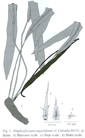
Elaphoglossum angustifrons A. Rojas, sp. nov. (Fig. 1). Type: MEXICO. Chiapas: Mapastepec, Cañada Honda, camino para el Arenal, 1250 m, 15 May 1982, J. Calzada et al. 9013 (Holotype: UC). ]]>
Epiphytic; rhizomes 2.5-4 mm diam, short-creeping; rhizome scales 4-8 x 0.5-1.0 mm, linear lanceolate, orange-yellowish, marginally entire to short-ciliate; phyllopodia 5-15 mm long; fronds (22-) 30-45 cm long; stipes 1/3-1/2 the frond length; stipe scales 2-5 x 0.5-1.0 mm, lanceolate, orange-yellowish, very dispersed, marginally short to long-ciliate, apically occasionally dark brown to blackish; blades 16-23 x 1.7-2.5 cm, narrowly oblance-olate to linear-elliptic, basically cuneate, apically narrowly acute; costal scales 2-5 x 0.5-1.0 mm, lanceolate, orange-yellowish with occasional blackish apex, marginally short to long-ciliate; blade scales 0.1-0.3 mm diam., stellate, orange-yellowish to brown, dispersed, present only on abaxial surface; veins evident, simple to 1-forked, 0.8-1.5 mm apart, diverging at 70-80° from costa; hydathodes absent; fertile fronds 17-43 cm long; stipes ca 1/2 the frond length; fertile blades 11-18 x 1-1.4 cm, narrowly elliptic to linear-elliptic, basically cuneate, apically acute to narrowly acute; intersporangial scales absent.
Distribution: Mexico; known only from Sierra de Juárez and Sierra de Chiapas at 1250-2100 m.
Paratypes: MEXICO. Chiapas: Jalte-nango, El Triunfo Reserve, trail from El Triunfo camp N to El Triunfo, 15° 39 N, 92° 50 W, 2100 m, R. Hampshire et al. 451 (MEXU). Oaxaca: Comaltepec, Ixtlán, 11.1 km SW de La Esperanza, carretera Oaxaca-Tuxtepec, entrada al camino deSan Isodro Yolox, 17°36 N, 96°23 W, 1950 m, A. Campos & R. Torres 902 (MEXU).
Elaphoglossum angustifrons resembles E. latifolium in short-creeping rhizome and short-ciliate rhizome scales, but differs in having thinner (2.5-4 mm vs. 5-15 mm diam.) rhizome, longer [1/3-1/2 the frond length vs. 1/6-1/4 (-1/3)] stipes, narrowly oblanceolate to linear-elliptic (vs. elliptic) and narrower (1.7-2.5 cm wide vs. 4-9 cm) blade. It is also similar to E. longicrure H. Christ in narrow rhizomes and blade shape, but differs in having longer (4-8 mm long vs. 2-4 mm) and dentate (vs. entire) rhizome scales, relatively longer [(22-) 30-45 cm long vs. 15-30 (-45) cm] fronds, and longer [1/3-1/2 the frond length vs. 1/10-1/5 (-1/3)] stipe.
Elaphoglossum delgadilloanum A. Rojas, sp. nov. (Fig. 2). Type: COSTA RICA Limón: Reserva Indígena Talamanca, Quebrada Heliotropo, entre Sukut y Purisqui, 9°2330" N, 82°5750" W, 650 m, 6 July 1989, A. Chacón 141 (Holotype: CR; Isotypes: F, MO). ]]>
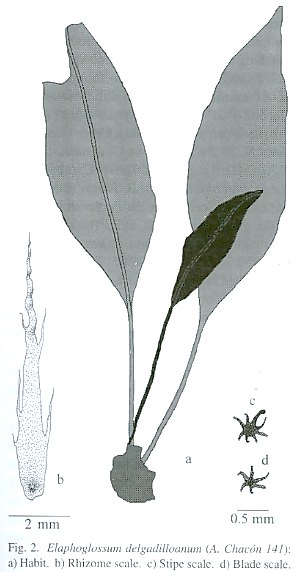
Epiphytic or rarely epipetric; rhizome 5-10 mm de diam., compact to short creeping; rhizome scales 10-30 x 1-2 mm, linear, orange-yellowish or in any times mixed with blackish scales, lustrous, crisped, marginally entire to occasionally long-ciliate; fronds (7-) 29-64 cm long, approximate; phyllopodia 5-15 mm (not seen by the scales); stipe (1/6-)1/3-2/5 of the fronds length; stipe scales 0.5-2 x 0.5-1 mm, lanceolate to arachnoids, black, lustrous, appressed, dispersed, marginally fimbriate; blade (6-) 16-38 x (2-) 3.5-7.2 cm, lanceolate to elliptic, coriaceous, basally broadly cuneate, apically acute to acuminate; blade scales 0.5-1 mm diam., arachnoids, black, lustrous, appressed, marginally long-ciliate, more dissected and dispersed in the adaxial surface; veins evident, 1-forked, 0.8-1.5 mm apart, diverging at 70-80° from costa; hydathodes absent; fertile fronds (8-) 19-36 cm long; stipe 1/3-1/2 of the fronds length; fertile blade 6-17 x 1.6-3.2 cm, lanceolate, basally broadly cuneate to obtuse, apically acuminate; costal scales 0.5-1 mm de diam., arachnoid, black, appressed, marginally long-ciliate; interespo-rangial scales absent.
Distribution: Costa Rica, Panamá and Colombia?; known of Cordillera de Tilarán, Cordillera Central, Cordillera de Talamanca, Cordillera de Tabasará, Cordillera de Veraguas, Cordillera de San Blás and Serranía del Darién at 500-1200 (-1450) m.
Paratypes: COSTA RICA. Alajuela: Los Ángeles de San Ramón, A. Brenes 14849 (NY); between Quebrada Quicuya and Quebrada Arrayanes, Cariblanco, 10°15 N, 84°11 W, 900 m, R. Lent 3587 (F). Cartago: 1.5 mi. E of Cachí, 10.2 mi. NE of junction at Paraíso, T. Croat 47068 (MO); Upala, Bijagua, camino de El Pilón a Río Celeste, 10°4230" N, 84°58 W, 600-700 m, G. Herrera 2084 (CR, MO). Heredia: Parque Nacional Braulio Carrillo, Quebrada Sanguijuela, 500 m, L. Gómez et al. 22946 (MO); vicinity of Colonia Virgen del Socorro in and around the finca of Sr. Carlos Molina, 2-5 km E of Cariblanco, 900 m, J. Utley & K. Utley 2834 (F). San José: Parque Nacional Braulio Carrillo, Estación Carrillo, Quebrada Sanguijuela, 500 m, L. Gómez et al. 22946 (NY). PANAMA. Chiriquí: Fortuna Dam proyect area, slope NW of confluence of Río Hornito and Río Chiriquí, 8°44 N, 82°13 W, 1050-1100 m, K. Sytsma & W. Stevens 2273 (MO). Coclé: La Mesa above El Valle, on both sides of jct. with road to Cerro Pilón, ca. 800 m, T. Croat 25402 (MO); adjacent to chicken farm, La Mesa, above El Valle, J. Dwyer & M. Nee 11939 (MO, NY); foot of Cerro Pilón, above El Valle de Antón, 2000 ft., D. Porter et al. 443 (MO), D. Porter et al. 4449 (MO), D. Porter et al. 4450 (MO); La Mesa, 2 km W of Cerro Pilón, 860 m, Sullivan 500 (MO); above El Potroso sawmill at continental divide, 8°38 N, 80°36 iW, 1200-1300 m, K. Sytsma 1764 (MO). Darién: along ridge trail from Cana up the Cerro Pirre Massif, 7°50 N, 77°40 W, 1000- 1300 m, R. Moran 5049 (F, MO, NY); Cana and vicinity, 2500 ft., R. Williams 926 (NY). Panamá: Cerro Campana along trail to summit, T. Croat 17187 (MO, NY); Cerro Jefe, vicinity of summit, 9°14 N, 79°22 W, 850 m, T. Croat 67039 (MO); road past Altos de Pacora, 3-3.5 mi. NE of Altos de Pacora, 7.8-8.2 mi. Above Pan American Hwy., 11.1-11.6 imi. beyond Lago Cerro Azul, 9°15 N, 79°25 iW, 700-750 m, T. Croat 68656 (MO); Alto Calvario above El Copé, ca. 6 km N of El Copé, atlantic slope, along trail through forest W off old lumbre trail wich leads down to Las Ricas, Limón and San Juan, 8°39 N, 80°36 iW, T. Croat 68772 (MO); Altura del Cerro Campana, ridge Wof the summit connecting with Cordillera del Llorón, 8°41 N, 79°56 iW, 840-900 m, M. Grayum et al. 9879 (F, MO); Cerro Campana, 8°40 N, 79°55 W, 700 m, G. Hamilton et al. 1170 (MO); summit of Cerro Campana, D. Porter et al. 4910 (MO), D. Porter et al. 4943 (MO, NY); Cerro Jefe, D. Porter et al. 5075 (MO), D. Porter et al. 5076 (MO); Parque Nacional Cerro Campana, 2 km N of Hwy. 707, 850 m, 8°42 N, 79°55 W, Stein & G. Hamilton 1165 (MO); Cerro Jefe, N. Torres & O. Guardia 162 (NY); Cerro Campana, at 2500 ft., E. Tyson 5332 (MO); Capira, Cerro Campana, 8°41 N, 79°54 W, ca. 900 m, H. Werff & J. Herrera 6219 (MO). Veraguas: Cerro Tute, summit, ca. 3 km N of Santa Fé, 8°31 N, 81°06 W, 1453 m, R. Moran 4060 (MO).
Elaphoglossum delgadilloanum resembles E. productum Rosenst. in its blackish abaxial blade scales, but differs in having arachnoid to stellate (vs. lanceolate) stipe scales, broadly lanceolate to elliptic (vs. elliptic) blades, blade base broadly cuneate (vs. narrowly cuneate), blue-green (vs. dark green) adaxialy blade surface, and larger (0.5-1.5 mm vs. 0.3-0.7 mm), longer ciliate (arachnoid margin vs. ciliate-dentate), dense (vs. dispersed) blade scales and distributed at less elevation [500-1200 (-1450) vs. 2000-2800 m]. Also it is similar to E. metallicum Mickel in its lanceolate blade, colored blade (blue green adaxialy), black and stellate stipe and blade scales, but differs in its compact (vs. short creeping) rhizome, and longer (10-30 mm long vs. 8-15 mm) rhizome scales.
The Central American material determinate as E. productum correspond to this species. This species is dedicated to Claudio Delgadillo Moya bryologist in the Instituto de Biología of the Universidad Nacional Autónoma de México.
]]>
Distribution: Mexico, Guatemala, Honduras and El Salvador; in Sierra de Juárez, Sierra de Los Cuchumatanes, Cerro Monte Cristo, and Montañas de Celaque at (1600-) 2100-2700 m.
Paratypes: MEXICO. Chiapas: Mpio. Tenejapa, NE side of the hill called Matsab, Paraje of Matsab, 7200 ft., D. Breedlove 15292 (NY); Mpio. San Cristóbal de Las Casas, Cerro Huitepec (Mukta Vits) W of San Cristóbal de Las Casas, 2700 m, D. Breedlove 23036 (NY); Mpio. Tenejapa, Paraje Banabil, 2700 m, D. Breedlove & A. Smith 22014 (NY); Mpio. San Cristóbal de Las Casas, E side of Zonthehuitz near summit, 2800 m, D. Breedlove & A. Smith 22093 (MEXU, NY); en el Cerro Huitepec, al W de San Cristóbal de Las Casas, 2500 m, E. Cabrera & H. Cabrera 3729 (IEB); Ghiesbreght 251 (NY); Mpio. Zinacantán, NW side of Mukta vits (Cerro Huitepec), 7000 ft., R. Laughlin 166 (NY); S side of Cerro Hueytepec, 5 km Wof Ciudad de Las Casas (San Cristóbal), 8900 ft., E. Little & A. Sharp 9854 (NY, UC, US); Unión de Juárez, Volcán Tacana, entre Talquian y la cima del volcán, 1600-2400 m, E. Martínez et al. 13214 (MEXU, UAMIZ); 3 mi. N of San Cristóbal de Las Casas on road up Cerro Zontehuitz, 7900 ft., J. Mickel 1230 (ENCB, NY, UC); Mpio. Tenejapa, in the Paraje Matsab, 8900 ft., A. Shilom 694 (ENCB, NY); Zinacantán, Cerro Mukrarriz, Huitepec, A. Shilom 8124 (MEXU). Michoacán: Mpio. Zinapécuaro, alrededores de Laguna Larga, Los Azufres, H. Díaz 4674-a (IEB). Oaxaca: Mpio. San Martín Peras, después de la desviación a Zochiquilazala y antes de la Y a San Martín Peras y Coycoyan, 2740 m, M. Cházaro et al. 7097 (CHAPA); Dist. Mixe, Mixistlán, 30 km al S de Totontepec, 2600 m, A. García et al. 1291 (MEXU, UAMIZ); Dist. Ixtlán, Sierra de Juárez, camino de Calpulalpan a Llano Verde, a 15 km al NE de Calpulalpan, 2400 m, D. Lorence & R. Cedillo 4207 (ENCB); Dist. Ixtlán, trail from San Pedro Nolasco N to the Llano Verde, 6000-7200 ft., J. Mickel & R. Hellwig 3774 (ENCB); Dist. Teotitlán, 26-29 km NE of Teotitlán del Camino, vicinity of pass at Puerto Soledad, 7000-7400 ft., J. Mickel & R. Hellwig 4124 (US), J. Mickel & R. Hellwig 4152 (UC); Dto. Tlacolula, 1-2 hrs N of Santa María Albarradas, ca. 6000 ft., J. Mickel & R. Hellwig 4362 (NY, US); Mixes, W slope of Cerro Zempoaltepetl to Yacoche, 8000-10000 ft., J. Mickel & S. Leonard 4623 (NY, UC); Mpio. Santiago Zacatepec, Carretera Mitla-Zacatepec, 21.6 km de Ayutla rumbo a Zacatepec, costado N del Cerro Zempoaltepetl, 17°1638" N, 96°0017" W, 2480 m, A. Rojas et al. 4434 (INB, MEXU, UAMIZ); Santiago Comaltepec, carretera de Ixtlán a Valle Nacional, después de Cerro Pelón, aprox. 20.7 km antes de Vista Hermosa, 17°3512" N, 96°2854" W, 2400 m, A. Rojas et al. 4464 (INB, MEXU, UAMIZ); Mpio. Santiago Comaltepec, carretera de Ixtlán a Valle Nacional, después de Cerro Pelón, aprox. a 20.7 km antes de Vista Hermosa, 17°3512" N, 96°2854" W, 2400 m, A. Rojas et al. 4476 (INB, MEXU, UAMIZ); Mixe, Mpio. Totontepec, 3.9 km al N de Yacochi, carretera Ayutla-Totontepec, 17°08 N, 96°04 W, 2610 m, R. Torres & A. Campos 10703 (MEXU); Sierra Madre Oriental, ca. 3.5 mi. NE of Cerro Pelón, 7500 ft., aprox. 17°38 N, 96°25 W, G. Webster et al. 17461 (GH, MEXU, UC). Veracruz: Mpio. Yecuala, along very windening road from Naolinco to Misantla, 13 km by road S of turnoff to Yecuala and 6 km by road N of Paz de Enrríquez, ca. 19°51 N, 96°4830" W, 1200 m, M. Nee et al. 26368 (F). GUATEMALA. Mpio. of Santa Eulalia, Sierra de Los Cuchumatanes, 8 mi. N of Santa Eulalia along road to San Mateo Ixtatan, 9200 ft., D. Breedlove 8591 (US). Chimaltenango: Chichavac, 2400-2700 m, A. Skutch 245 (US). Huahuetenango: Sierra Cuchumatanes road to San Juan Ixcoy, 3000 m, A. Molina 21310 (F, NY, US). Quiché: Chajul, 8000 ft., D. Smith 3218 (MO, US). Zacapa: between Miramundo and summit of Montaña Miramundo, between Jalapa and Mataquescuintla, 6 mi. S of Mira-mundo, 2000-2500 m, J. Steyermark 32784 (F); between Loma El Picacho and Cerro de Monos, 2000-2600 m, J. Steyermark 42813 (F). HONDURAS. Francisco Morazán: drainage of the Río Yeguare, at about 14° N, 87° W, 1600 m, A. Molina 4082 (F). Lempira: near Gracias, Montaña de Celaque, between mountain but above base camp, 2500 m, Chorley 319 (MEXU, MO); Celaque National Park, trail from camp 1 to Río Naranjal, 14°33 N, 88°40 W, 2000 m, R. Moran 5543 (F); Celaque National Park, along Río Arcágual, upstream from base camp 2, 10.5 km WSW of the town of Gracias, 14°345" N, 88°415" W, 2500 m, R. Moran 5599 (MO). Ocotepeque: Montains Cocal of Cordillera Merendón, 20 km NW of Ocotepeque, 1800 m, A. Molina 22134 (F). Santa Bárbara: 7 km N of El Mochito, en the E slope of Mt. Santa Bárbara, 14°55 N, 88°7 W, 2200-2500 m, R. Moran 5680 (MO, UC). EL SALVADOR. Chalatenango: Cerro El Pital, 2700 m, R. Seiler 397 (F), R. Seiler 429 (F); El Zancudo 1900 m, R. Seiler 992 (F). Santa Ana: Cordillera Miramundo, mountains of Monte Cristo, 2000-2200 m, A. Molina et al. 16855 (F, US); Bosque Monte Cristo, 2250 m, R. Seiler 170 (F).
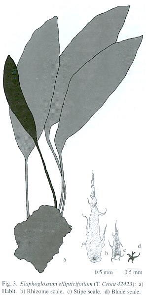
Elaphoglossum ellipticifolium resembles E. productum in its long and orange-brownish rhizome scales, and blackish abaxial blade scales, but differs in having short creeping (vs. compact) rhizome, broader (1.5-2.5 mm wide vs. 0.5-1.5 mm) and marginally entire (vs. ciliate) rhizome scales. It is also similar to E. lat-ifolium, but differs in having larger (10-20 x 1.5-2.5 mm vs. 5-9 x 0.5-1.0 mm) rhizome scales, longer [1/3-2/5 of frond length vs. 1/6-1/4 (-1/3)] stipes, broadly elliptic (vs. elliptic) blades, and blackish (vs. orange-reddish to pale brown) abaxial blade scales.
This species is named E. ellipticifolium for the elliptic blade. ]]>
Epiphytic; rhizomes 3-5 mm diam., short-creeping; rhizome scales 7-12 x 0.8-1.0 mm, linear-lanceolate, orange-yellowish, marginally entire to occasionally longciliate; phyllopo-dia present, 10-15 mm long; fronds 27-43 cm long, 2-7 mm distant; stipes 1/10-1/5 (-1/4) of frond length; stipe scales 3-7 x 0.7-1.0 mm, ovate lanceolate to linear-lanceolate, orange-yellowish, marginally entire to occasionally long-ciliate, present only on stipe base; blades 21-32 x 5.3-6.2 cm, elliptic, coriaceous, basally narrowly cuneate to attenuate, apically acute; costal scales 0.3-1.0 x 0.2-0.5 mm, lanceolate to stellate, orange-yellowish, marginally long-ciliate; blade scales 0.1-0.3 mm wide, stellate, orange-yellowish, dispersed, marginally long-ciliate, present only on abaxial surface; veins evident, 1-2-forked, 1.0-1.5 mm apart, diverging at 75-85° from costa; hydathodes absent; fertile fronds not seen.
Distribution: Costa Rica; only in Isla del Coco at 100-300 m.
Paratypes: COSTA RICA. Puntarenas: Cocos Island, twin mts., L. Gómez 3348 (CR, F, MO); Isla del Coco, a lo largo del Río Wafer, 100-300 m, L. Gómez 4509 (CR); Isla del Coco, entre Chatham y Valle Wafer, 100-232 m, L. Gómez 18052 (CR); Parque Nacional Isla del Coco, Isla del Coco, sendero a Cerro Iglesias, entre la base y la punta de Cerro Pelón, 5°3155" N, 87°0445" W, 350-500 m, A. Rojas 3613 (CR, INB, MO, NY, UC, US).
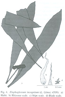
Elaphoglossum incognitum resembles E. latifolium in its creeping rhizomes, size and color of rhizome scales, and frond shape and size, but differs in having thinner (3-5 mm vs. 5-12 mm) rhizomes, entire to ciliate (vs. den-tate to dentate-ciliate) and longer (7-12 mm vs. 4-9 mm) rhizome scales, relatively shorter [1/10-1/5 (-1/4) of frond length vs. 1/6-1/4 (-1/3)] stipes, long-ciliate (vs. ciliate-dentate) margins of stipe scales, and gold-yellowish Fig. 4. Elaphoglossum incognitum (L. Gómez 4509): a) Habit. b) Rhizome scale. c) Stipe scale. d) Blade scale. (vs. orange-reddish to brown-yellowish) abaxial blade scales. ]]>
This species has been really few collected and incorrectly identified as E. latifolium, remaining in incognito condition.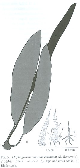
Epiphytic; rhizomes 8-12 mm diam., compact to short-creeping, commonly horizontal; rhizome scales 5-12 x 1-2 mm, lanceolate, orange-yellowish to pale brown, marginally entire; phyllopodia present, 15-25 (-50) mm long; fronds (15-) 30-64 cm long, approximate to 2 (-5) mm distant; stipes 1/6-1/5 of frond length; stipe scales 3-7 x 1.5-3.0 mm, ovate-lanceolate, orange-yellowish to pale brown, marginally entire to occasionally short-ciliate, present over the entire stipe; blades (12-) 24-53 x 2.7-6.1 cm, narrowly elliptic to oblong-elliptic, coriaceous, basally cuneate to attenuate, apically acute; costal scales 1-3 x 0.5-1.5 mm, orange-yellowish to pale brown, marginally erose to long-ciliate; blade scales 0.3-1.0 x 0.2-0.5 mm, deltate to stellate, orange-yellowish to pale brown, dispersed, marginally long-ciliate, present only on abaxial surface; veins evident, simple to 2- forked, ca. 1 mm apart, diverging at 75-85° from costa; hydathodes absent; fertile fronds 22-33 cm long; stipes 1/5-2/5 of frond length; fertile blades 15-27 x 1.9-3.7 cm, narrowly elliptic, basally attenuate to acute, apically acute; intersporangial scales absent.
Distribution: Mexico, Guatemala, Honduras, El Salvador and Nicaragua at (500) 700-1900 (-2750) m.
Paratypes: MEXICO. Chiapas: ]]> Mpio. Chilón, marsh just S of Bachajón, 900 m, D. Breedlove 22196 (NY); Mpio. Ocozocoautla de Espinoza, 18-20 km N of Ocozocoautla alon road to Mal Paso, 800 m, D. Breedlove & A. Smith 21840 (NY); Mpio. Ocosocuautla de Espinosa, 3 km N of Ocozocoautla along road to Mal Paso, 900 m, D. Breedlove & A. Smith 21972 (CHAPA, MEXU, MO); Valle de Corvotá, M. Bourgeau 2109 (US); Ghiesbreght 274 (GH); Mpio. San Juan Chamula, 6900 ft., C. Santíz 390 (ENCB). Hidalgo: Mpio. Tenago de Doria, Temapa, J. Gimate s. n. (ENCB). Oaxaca: 60 km by road N of Pochutla, on road to Oaxaca (Hwy. 175), Río Jalatengo, 1440 m, W. Anderson 13213 (MEXU); ]]> L. López & G. Martin 81 (MO); Mpio. Tehuantepec, Dist. Tehuantepec, al S de Santa Lucia, Rancho Limón, 17 km al O de Tehuantepec, C. Martínez 444 (MEXU); Río Cascabel, C. Mell 2238 (US); Villa Alta, 3-4 km S of Villa Alta on trail toward Betaza, 5500 ft., J. Mickel 1128 (ENCB, MEXU, NY, UC); Dist. de Mixes, Vicinity of Zacatepec, along trail SW toward Yacoche for ca. 1 mile, 4700 ft., J. Mickel 1620 (NY, UC); Ixtlán, 29 km S of Valle Nacional, 80 km N of Ixtlán de Juárez, trail E of Rte. 175 at Campamento Vista Hermosa toward Ladú, 1 hour bike down to Río de La Trucha, 1500-2000 ft., ]]> J. Mickel 6405 (ENCB); Tuxtepec, 1-3 km S of Usila, 1000 ft., J. Mickel 7386 (NY), J. Mickel 7387 (ENCB, NY); Dist. Mixes, N slope of Cerro Zempoaltepetl, trail from Totontepec to La Candelaria, 2700-7200 ft., J. Mickel & S. Leonard 4751 (NY); Dist. Mixes, E slope of Cerro Zempoaltepetl, 2-3 hrs SW of Zacatepec on trail to Tomazulalpam, 5200-6500 ft., J.Mickel & S. Leonard 4877 (NY, UC); Dist. Pochutla, 181 km S of Oaxaca, 64 km N of Pochutla, 4500 ft., J. Mickel & S. Leonard 5086 (ENCB, IEB); Dist. Pochutla, 45 km N of Pochutla, 13 km N of Candelaria, ca. 3300 ft., J. Mickel & S. Leonard 5226 (MEXU, NY); Tuxtepec, 8 km S of Valle Nacional on Rte. 175, 1850 ft., J. Mickel ]]> (ENCB); 15 km S of bridge at Valle Nacional, trail from Puerto Eligio E toward Soyalapan, 1500-2400 ft., J. Mickel & L. Pardue 6521 (NY), J. Mickel & L. Pardue 6524 (NY); 8 km S of Valle Nacional on Rte. 175, 1850 ft., J. Mickel & L. Pardue 6678 (ENCB, NY, US); Mpio. San Miguel Chimalapa, paso El Pedregal del Río Portamonedas, ca. 2 km al S de Benito Juárez, ca. 36 km en linea recta al N de San Pedro Tapanatepec, 16°42 N, 94°08 W, 900 m, S. Moya 2182 (NY); Mpio. Santa María Chimalapa, Cerro de Los Pavos, al N del Cerro Guayabitos y al O del Río Portamonedas, ca. 47 km en linea recta al N de San Pedro Tapanatepec, 16°47 N, 94°10 ]]> S. Moya 3934 (NY); Dist. Putla, a 10 km al NE de Putla, 950 m, L. Rico et al. 569 (MEXU); Mpio. Totontepec, Dist. Mixe, Chinantequila, 17°19 N, 95°59 W, ca. 1300 m, E. Vargas & G. Martin 118 (MEXU); Choapan, San Pedro de Jepinapa, Santiago de Jocotepec, region of Chinantla, J. Vera 3402 (ENCB, US). Puebla: Mpio. Zacapoaxtla, La Escalera, 1200 m, F. Ventura 22178 (ENCB, IEB); S of Panuatlan, E. Hernández 813 (US). Veracruz: Alto Lucero, Mata Verde, entre Rancho Nuevo y Tierra Blanca, 19°46 N, 96°41 W, 1200 m, G. Castillo & F. Vázquez 1469 (F); Cantón de Huatusco, 1200 m, C. Conzatti 798 (GH); Ciudad de Córdova, ]]> H. Fink 107 (MO); Zacuapan, C. Purpus 1913 (MO). GUATEMALA. Alta Verapaz: 4 mi. up road to Oxec, along road wich turns N off Highway 7E (to El Estor), ca. 6 km NE of Panzós, 500 m, T. Croat 41589 (MO). Guatemala: Chillani, 1500 m, Rojas 60 (US). Huehuetenango: Cerro Victoria, across river from Finca San Rafael, Sierra de los Cuchumatanes, 800 m, J. Steyermark 49602 (US). Santa Rosa: O. Cook 250 (US); Chupadero, 5000 pies, D. Smith 4077 (MO, NY, US). Zacapa: along Río Lima, Sierra de Las Minas, between Río Hondo and summit of mountain at Finca Alejandría, 1500-1700 m, J. Steyermark 29637 (F); Sierra de Las Minas, upper ]]> J. Steyermark 42446 (F, US). HONDURAS. Comayagua: Siguatepeque, ESNACIFOR, 1180 m, A. Horwath 97 (F); Montaña de San Juanillo, Reserva Biológica Cordillera de Montecillos, 14°30 N, 87°53 W, 1900 m, Paul & S. Aguilar 846 (EAP, MO, TEFH?); vicinity of Siguatepeque, about 1050 m, P. Standley & J. Chacón 6266 (F); Trincheras, N of Seguatepeque, T. Steeves & P. Ray 481 (US); near El Achote, hills above the plains of Siguatepeque, 1350 m, T. Yuncker et al. 5848 (NY, UC, US); near Siguatepeque, 1050 m, T. Yuncker et al. 5903 (NY); near El Achote, hills above the ]]> T. Yuncker et al. 5976 (US); T. Yuncker et al. 5976 (NY, UC). Copán: Quebrada Las Honduras, 1 km SO de Santa Rosa de Copán, 1160 m, R. Romero 4 (MO, TEFH?). Cortés: San Pedro Sula, La Cumbre, Thieme 27 (UC). El Paraíso: Quebrada Tapahuasca, 1300 m, A. Molina 14644 (F, US). Francisco Morazán: Cerro El Uyuca, 25 km NE de Tegucigalpa, 1700 m, F. Argeñal 82 (MO, TEFH); Valle de Ángeles, Quebrada Hierba Buena, 15 km NE de Tegucigalpa, 1500 m, Y. Calderón 52 (MO, TEFH?); La Montañita, 8 km al SE de Tegucigalpa car-retera a Danlí, 1500 m, Clotter 79 (MO, ]]> G. Davidse & G. Pilz 31606 (MO, NY); Cerro Uyuca, 14 km E de Tegucigalpa, 1780 m, Erazo 139 (MO, TEFH?); Picacho, 8 km N de Tegucigalpa, 1487 m, M. Figueroa 80 (MO, TEFH?); El Hatillo, 11 km N de Tegucigalpa, 1600 m, D. Hernández 77 (MO); Valle de Ángeles, orilla de quebrada, 1000 m, M. Lara 33 (MO, PMA, TEFH?); Quebrada Agua Amarilla, Zamorano, 37 km SE de Tegucigalpa, 800 m, R. Maradiaga 43 (MO, TEFH?); El Hatillo, 11 km NE de Tegucigalpa, 1600 m, D. Molina 77 (MO, NY, TEFH?); bank of Agua Amarilla Creek, 5 km of El Zamorano, 900 m, A. Molina 26271 (F); Quebrada El Gallo, NE slopes of Cerro ]]> C. Morton 7048 (US); along Río Agua Amarilla, NE slopes of Cerro de Uyuca, 900-1100 m, C. Morton 7565 (MO, NY); La Montañita, 8 km al SE de Tegucigalpa sobre la carretera a Danlí, 1500 m, C. Navarro 15 (MO, TEFH?); 20 km E de Tegucigalpa, Montaña La Tigra, 1400 m, C. Nelson et al. 3878 (MO); El Hatillo, 15 km NE de Tegucigalpa, 1500 m, I. Padilla 53 (MO, TEFH?); El Hatillo, 10 km NE de Tegucigalpa, en la carretera a San Juancito, 1400 m, G. Pilz & M. Pilz 1387 (MO, TEFH?); El Hatillo, 1600 m, O. Silva 142 (MO, TEFH?); Valle de Ángeles, 20.8 km NE de Tegucigalpa, 1200 m, Soihet 63 (MO, TEFH); region of Agua Amarilla, on hwy. above ]]> P. Standley 12288 (F), P. Standley 12309 (F); along and near Río Agua Amarilla, above El Zamorano, 1000-1200 m, P. Standley 12848 (F); mountain slope along Río Agua Amarilla, NW of El Zamorano, 1100-1200 m, P. Standley 21766 (F), P. Standley 21498 (F); along Quebrada El Gallo above El Jicarito, 900-1000 m, P. Standley 22467 (F); mountain slope along Río Agua Amarilla, NW of El Zamorano, 1100-1200 m, P. Standley 22892 (F), P. Standley 22928 (F); region of El Jicarito, above El Zamorano, 900-1000 m, P. Standley 24210 (F); Haya Grande, 1500 m, L. Williams & A. Molina 13276 (US). Olancho: Montaña Los Zapotes, ]]> C. Soto 103 (MO, TEFH?); trail between Catacamas and La Presa, N of Catacamas, 500-600 m, P. Standley 18709 (F). Santa Bárbara: Aldea de Uncana, a 10 km al E de Ilama, 40 0im, S. Paz 82 (MEXU); San Pedro Sula, 1000 ft., D. Smith 5667 (NY, US). Yoro: cerro between Río Guán Guán and Río Texíguat, E. of Cerro Guán Guán, S of San José in the Río Leán Valley, eastern end of the Cordillera de Nombre de Dios, 15°2930" N, 87°2700" W, 700-1870 m, MacDougal et al. 3241 (MO, UC). EL SALVADOR. San Salvador: on the road between San Salvador and ]]> M. Carlson 593 (F). Santa Ana: Hacienda San Miguel near Metapán, between Río San Miguel and summit of Cerro El Pinal, 600-1380 m, M. Carlson 753 (F). Chalatenango: S. Calderón 1928 (US); El Jute, S. Calderón 2448 (F); Río Nunuapa near La Palma, 1000 m, R. Seiler 258 (F), R. Seiler 578 (F, MO). NICARAGUA. Estelí: 12.1 km NW Estelí near El Rodeito, ca. 1400 m, R. Kral 69202 (CR, UC); Quetzalcayán, al E del Cerro Tisey, 12°59 N, 86°24 W, 900-1100 m, P. Moreno 17838 (MO); N. slope or Cerro Tomabú, ca. 13°02 N, 86°17 W, 1200- 1400 m, W. Stevens ]]> (CR, MO, NY, UC). Jinotega: vicinity of Jinotega, 1030-1300 m, P. Standley 9554 (F). Nueva Segovia: ca. 5.2 km N of San Fernando, valley of Río San Fernando (800 m), NE to Portillo Los Coyoles (1083 m), SW up narrow quebrada to Cerro El Peñascal (1125 m), 13°02-03 N, 86°19-20 W, W. Stevens & B. Krukoff 3309 (MO).
Elaphoglossum mesoamericanum resembles E. latifolium in its pale rhizome scales and short-ciliate stipe and blade scales, but differs in having broader (1-2 mm vs. 0.5-1.0 mm), orange-yellowish (vs. orange-reddish to brown) and entire (vs. short-ciliate-dentate) rhizome scales, and relatively narrow (2.7-6.1 cm vs. 4-9 cm) and narrowly elliptic to oblong-elliptic (vs. elliptic to broadly elliptic) blades. It is also similar to E. clewellianum Mickel in size, in having similarly colored and entire rhizome scales, and narrowly elliptic to oblong-elliptic blades, but differs in its shorter (fronds approximate to 2 (-5) mm distant vs. 5-20 mm distant) rhizomes, shorter [1/6-1/5 of frond length vs. (1/5-) 1/3-1/2] and straw colored (vs. orange-reddish to straw colored) stipes. This species differs of E. chartaceum (Baker ex Jenman) C. Chr. of Caribbean islands in entire (vs. short-ciliate) rhizome scales, relatively longer (1/5-1/3 of frond length vs. 1/6-1/5) stipes, broader (4-6 times as long as wide vs. 6-8 times) blades, broadly cuneate to obtuse (vs. long cuneate to attenuate) blade base, and shorter (0.5-1 mm vs. 1-1.5 mm) veins distance.
The name refers to the distribution area (Mesoamerican) and because is very common here.
]]>
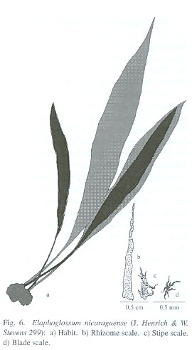
Distribution: Nicaragua; from Cordillera Isabelia at 1250-1600 m.
Paratypes: NICARAGUA. Estelí: Cerro Quiabú, situado a unos 8 km NO de la Ciudad de Estelí, 1500-1600 m, A. Grijalva & M. Araquistain 618 (HNMN?, MO).
Elaphoglossum nicaraguense resembles E. latifolium in the shape and color of its rhizome scales, but differs in having compact (vs. short-creeping) rhizomes, entire (vs. ciliate-dentate) margins of rhizome and stipe scales, narrower (2.6-4.0 cm vs. 4-9 cm ), linear-elliptic (vs. elliptic) and chartaceous to subcoriaceous (vs. coriaceous) blades, and blackish (vs. orange-reddish to brown) costal scales. This species resembles E. talamancanum A. Rojas in its linear-elliptic blades and blackish costal scales, but differs in having orange-yellowish (vs. orange to reddish-brown) rhizome scales, relatively longer (22-32 cm vs. 8-27 cm) and chartaceous to subcoriaceous (vs. coriaceous) blades, and low-elevation distribution (1250-1300 m vs. 2300-3000 m). The names refers to the apparently endemic distribution only in Nicaragua.
]]>
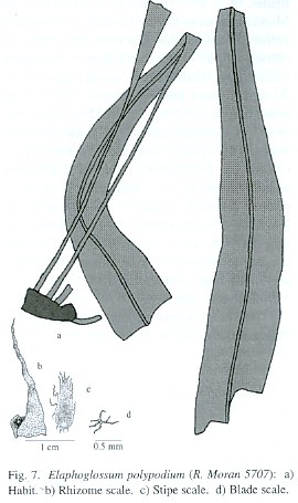
Distribution: Mexico, Guatemala and Honduras; in Sierra de Juárez, Sierra de Las Minas and Santa Bárbara Mountains at 1400- 2500 m.
Paratypes: Oaxaca: Dist. Cuicatlán, La Escalera camino de Zantla a Papalo, 2000 m, R. González & C. Conzatti 16822 (GH); Dist. Villa Alta, 3500 ft., B. Hallberg 1508 (ENCB). GUATEMALA. Alta Verapaz: near Tactic, above the bridge across Río Frío, 1400-1500 m, P. Standley 90496 (US).
Elaphoglossum polypodium resembles E. latifolium in its short-creeping rhizomes, frond size and elliptic blades, but differs in having longer (1/3-1/2 of frond length vs. 1/4-1/3) stipes, narrowly elliptic to narrowly oblanceolate (vs. elliptic) and very coriaceous (vs. chartaceous to subcoriaceous) blades, and brown to blackish (vs. orange-yellowish) blade scales. It is also similar to E. andicola (Fée) T. Moore, but differs in having smaller (5-10 mm long vs. 7-18 mm), brown-yellowish (vs. orange-yellowish to blackish), plane (vs. twisted) and deciduous (vs. persistent) rhizome scales, narrowly elliptic to narrowly oblanceolate (vs. elliptic) blade. ]]>
The name make reference to longer and persistent phyllopodia.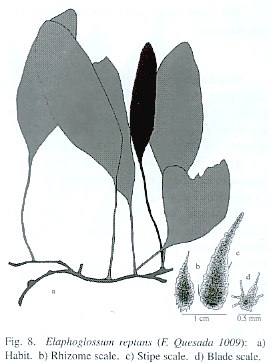
Terrestrial; rhizomes 1.5-2.0 mm diam., long-creeping; rhizome scales 1-1.5 x 0.3-0. 6imm, ovate to ovate-lanceolate, blackish, desiduous, marginally entire to denticulate; phyllopodia present, 15-25 mm long; fronds 23-27 cm long, 20-30 mm distant; stipes ca. 1/3 of frond length; basal stipe scales 2-3.5 x 0.4-0.8 mm, linear-lanceolate, brown with paler margin, marginally entire to occasionally denticulate, dense; medial stipe scales 3-5 x 1.0-1.5 mm, lanceolate, bicolorous with brown central line and yellowish to pale brown margin, dispersed, marginally entire to dentate; blades 16-18 x 5.0-6.5 cm, ovate to elliptic-lanceolate, coriaceous, basally cuneate, apically obtuse to rounded; blade scales 0.1-0.3 mm wide, stellate, orange-yellowish, dispersed, marginally long-ciliate, present only on abaxial surface; veins evident, simple to 1-forked, 1.0-1.5 mm apart, diverging at 70-85° from costa; hydathodes absent; fertile fronds 22.5 cm long; stipes ca. 1/2 of frond length; fertile blades 10.5 x 2.6 cm, elliptic-lanceolate, basally obtuse, apically obtuse; intersporangial scales absent.
Distribution: Costa Rica; known only from Isla del Coco at 350-600 m.
Paratype: COSTA RICA. Puntarenas: Isla del Coco, Parque Nacional Isla del Coco, sendero a Cerro Iglesias, 5°3240" N, 87°0320" W, 400-600 m, F. Quesada 1009 (INB). ]]>
Elaphoglossum reptans resembles E. lingua (C. Presl) Brack. in the shape and color of its rhizome scales and lanceolate blades with obtuse to rounded apex, but differs in having more creeping (fronds 20-30 mm distant vs. 5-20 mm) rhizomes, entire (vs. irregularly dentate) basal stipe scales, bigger (3-5 x 1.0- 1.5 mm vs. 1-2 x 0.3-0.7 mm), yellowish to pale brown with brown central line (vs. blackish) and entire to dentate (vs. long-ciliate-dentate) apical stipe scales, and orange-yellowish (vs. brown to blackish) blade scales.The name make reference to long-creeping rhizome.
Elaphoglossum tejeroanum A. Rojas, sp. nov. (Fig. 9). Type: MEXICO. Chiapas: Escuintla, El Triunfo, near Colonia Jalapa, 16 km W of Escuintla, 900 m, 14 July 1948, E. Matuda 18091 (Holotype: F; Isotype: US).
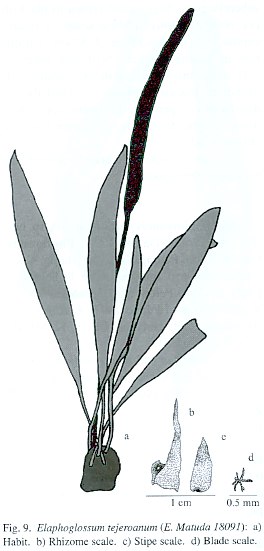
Epiphytic or terrestrial; rhizomes 5-10 mm diam. (without scales), compact to short-creeping; rhizome scales 8-15 x 1.0-2.5 mm, lanceolate, orange-yellowish, marginally entire; phyllopodia present, 7-15 mm long; fronds 25-42 cm long, 3-10 mm apart; stipes 1/4-2/5 of frond length; stipe scales 2-6 x 1.0- 2.0 mm, orange-yellowish to pale brown, marginally entire to occasionally short-ciliate, present over the entire stipe; blades 18-27 x 2.4-3.8 cm, narrowly elliptic to oblong-elliptic, coriaceous, basally cuneate to broadly cuneate, apically acute; costal scales 1-3 x 0.5-1.5 mm, orange-yellowish to pale brown, marginally entire to erose; blade scales 0.1-0.3 wide, stellate, orange-yellowish to pale brown, dispersed, marginally long-ciliate, present only on abaxial surface; veins commonly evident, simple to 2-forked, 1-2 mm apart, diverging at 70-80° from costa; hydathodes absent; fertile fronds 30-45 cm long; stipes 1/3-1/2 of frond length; fertile blades 17-25 x 1.5-2.7 cm, elliptic to linear-elliptic, basally cuneate, apically acute; intersporangial scales absent.
Distribution: Mexico, Honduras and Nicaragua; in Sierra de Manantlán, Sierra Madre de Chiapas, Cerro de Uyuca and Volcán Mombacho at 900-1800 m. ]]>
Paratypes: MEXICO. Chiapas: Mpio. Unión de Juárez, a 1 km de Chiquihuite, 1800 m, E. Martínez 20674 (MEXU). Jalisco: Sierra de Manatlán, 30-35 km SE of Autlán, precipitous seward facing slopes, 1-4 km below the summit called "La Cumbre", near the lumber orad between El Chante and Cuzalapa and above the abandoned site of Durazno, 19°32 N, 104°14 W, 1500-1900 m, R. McVaugh 23223 (ENCB). Michoacán: Mpio. Coalcomán, La Verbabuena del Naranjillo, Cañada del Colorín, 1400 m, H. Díaz & E. Pérez 6180a (IEB). Oaxaca: 60 km by road N of Pachuca on road to Jalatengo (Hwy. 175), 1440 m, W. Anderson 13213 (IEB); Mpio. Juquila, ca. 80 km SSW of Sola de Vega, seaward side of the pass 25 km above San Gabriel Mixtepec, and ca. 30 km of the Río Verde crossing at Juchatengo, 1450-1700 m, R. MacVaugh 22375 (ENCB). Veracruz: borde E del Volcán San Martín Tuxtla, 1650 m, J. Beaman & C. Alvarez 5693 (MEXU). GUATEMALA. San Marcos: above Finca El Porvenir, up Cerro de Monos, S facing slopes of Volcán Tujumulco, 1400-1700 m, J. Steyermark 37379 (F). HONDURAS. Francisco Morazán: Cerro de Uyuca, La Labranza and vicinity, along trail to summit, 1600-1800 m, P. Standley 23069 (F); slopes of Cerro de Uyuca, 1500 m, P. Standley & L. Williams 743 (F). NICARAGUA. Granada: on Mombacho Volcano, 1300 m, L. Williams & A. Molina 20018 (F).Elaphoglossum tejeroanum resembles E. latifolum in its short-creeping rhizomes, shape and size of the fronds, elliptic blades, and color and size of the blade scales, but differs in having shorter (8-15 mm vs. 15-22 mm) and plane (vs. twisted) rhizome scales, relatively shorter [1/4-2/5 of frond length vs. ca. 1/3) stipes, and 0.3-1.5 mm wide (vs. absent) stipe apex scales. It is also similar to E. tonduzii H. Christ in its narrowly elliptic blade and dense stipe scales, but differs in longer [1/4-2/5 of frond length vs. 1/12-1/6) stipe and cuneate (vs. attenuate) blade base.
This species is dedicated to Daniel Tejero Díez, Mexican Pteridologist of Universidad Nacional Autónoma, Sede Iztacala.
Elaphoglossum terrestre A. Rojas, sp. nov. (Fig. 10). Type: COSTA RICA. Puntarenas: Coto Brus, Cordillera de Talamanca, Parque Internacional La Amistad, Cerro Pittier, sendero entre Cerro Gemelo y Cerro Pittier, 9°0345" N, 82°5615" W, 2700-2850 m, M. Moraga & A. Rojas 428 (Holotype: INB; Isotypes: CR, F, MEXU, MO, NY, US, UC).
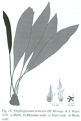
Terrestrial; rhizomes 4-12 mm diam., compact to very short-creeping; rhizome scales 2-5 (-7) x 1-2 mm, lanceolate to linear-lanceolate, dark brown to blackish, marginally entire; phyllopodia present, 8-15 mm long; fronds 15-40 (-60) cm long; stipes 1/5-3/5 of frond length; stipe scales 1-3 (-5) x 0.5-1.5 (-2.0) mm, ovate-lanceolate, pale brown to brown, marginally entire to occasionally short-ciliate, present on stipe base; blades 11-28 (-42) x (1.7-) 2.5-7.0 cm, elliptic, coriaceous, basally cuneate, apically acute; costal scales 0.5-1.5 x 0.5-1.0 mm, dark brown to blackish, marginally erose to short-ciliate; blade scales 0.2-0.5 wide, stellate, brown to dark brown, dispersed, marginally short- to medium-ciliate, present only on abaxial surface; veins evident, simple to 1-forked, 1-2 mm apart, diverging at 75-85° from costa; hydathodes absent; fertile fronds 17-52 cm long; stipes 2/5-1/2 of frond length; fertile blades 10.5-26 x 1.6-3.1 cm, elliptic, basally cuneate, apically acute; inter-sporangial scales absent. ]]>
Distribution: Costa Rica, on the Pacific slopes of the Cordillera de Talamanca at 2200-3300 m.Paratypes: COSTA RICA. Puntarenas: Buenos Aires de Ujarrás, estribaciones del Cerro Amú, Macizo Dúrika, 9°2110" N, 83°1730" W, 2500 m, A. Chacón 482 (INB, MO, UC); Ujarrás, cuenca superior del Río Ceibo, 9°2110" N, 83°1638" W, 2200-2500 m, M. Valerio 168 (CR, MO, K); Cerro Cuericí, Y. Widmer 387 (NY). San José: Pérez Zeledón, Cordillera de Talamanca, Parque Nacional Chirripó, Monte sin Fé, 9°2705" N, 83°3125" W, 2900-3300 m, A. Rojas 2860 (CR, INB, MO, NY, UC); entre Llano Bonito y antes de Monte sin Fé, 9°2655" N, 83°3205" W, 2600-2900 m, A. Rojas 2887 (CR, INB, MO, NY, UC).
Elaphoglossum terrestre resembles E. latifolium in its long and orange-reddish rhizome scales, but differs in having compact to very short-creeping (vs. short-creeping) rhizomes, shorter (2-5 (-7) mm vs. 4-9 mm) and dark brown to blackish (vs. orange-reddish to brown) rhizome scales, and dark brown to blackish (vs. orange-reddish to brown) costa and blade scales. It is also similar to E. sartorii (Liebm.) Mickel, but differs in its compact to very short-creeping (vs. short-ascending) rhizomes and shorter [2-5 (-7) mm vs. 10-15 mm] and dark brown to blackish (vs. orange-yellowish to pale brown) rhizome scales.
The name refers to terrestrial habitat.
Elaphoglossum variabile A. Rojas, sp. nov. (Fig. 11). Type: COSTA RICA. Alajuela: San Ramón, Cordillera Central, Los Angeles, Hotel y Finca Villa Blanca, propiedad de Rodrigo Carazo O., 10°1255" N, 84°3005" W, 900-1100 m, 20 July 1996, A. Rojas et al. 2793 (Holotype: INB; Isotypes: CR, MO).
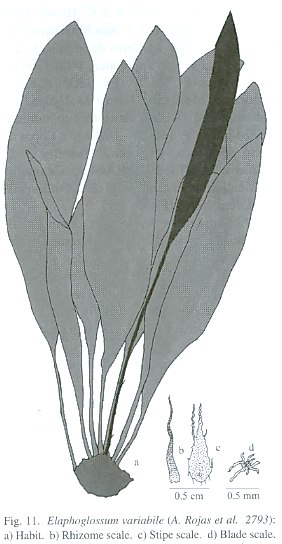
Distribution: México, Guatemala, Belize, Honduras, Nicaragua, Costa Rica and Panama, in Sierra Madre Oriental, Sierra de Juárez, Sierra Norte de Chiapas, Maya Mountains, Sierra de Las Minas, Cordillera Isabelia, Cordillera Dariense, Cordillera Chontaleña, Cordillera de Guanacaste, Cordillera de Tilarán, Valle Central, Cerros de Escazú, Fila Costeña, Cordillera de Talamanca, Península de Osa, Cordillera de Tabasará and Cordillera de Veraguas at (0-) 500-1300 (-1800) m.
Paratypes: MEXICO. Chiapas: Mpio. Cintalapa, SE of Cerro Baulon, the border with the state of Oaxaca, 16 km NW of Rizo de Oro, along a logging road to Colonia Figeroa, 1600 m, D. Breedlove 27612 (MEXU); Mpio. Ocosingo, near Laguna Ocotal Grande, ca. 25-30 km SE of Monte (Cerro) Libano (which is ca. 45 km E of Ocosingo), 950 m, R. Dressler 1610 (GH, MEXU); Ocosocoautla, 16°52 N, 93°27 W, 800 m, M. Heath & A. Long 1962 (MEXU); Mpio. Rayón, arriba del Cerro de Selva Negra a unos 150 m, y a 1.6 km ]]> M. Magaña & S. Zamudio 283 (MEXU, MO); Mpio. Ocosingo, 3 km al W de Nueva Veracruz, camino a Ixcan, sobre la carretera fronteriza del S, en zona de Marquez de Comillas, 150 m, E. Martínez 1348 (MEXU); Mpio. Ocosingo, 2 km al NE de Bonbampale, sobre la Sierra de Cojolite, 350 m, E. Martínez 7934 (MEXU); Mpio. Ocosingo, a 57 km al W del vértice del Río Chixoy, camino a Chajul, 150 m, E. Martínez 13568 (MEXU); Mpio. Ocosingo, en Estación Chajul, 150 m, E. Martínez et al. 25066 (MEXU). Oaxaca: Mpio. Santa María Chimalapa, Río Verde, 7 km en linea recta al NNE de Santa María Chimalapa, ]]> P. Caletti et al. 88 (CHAPA, MEXU, MO); Mpio. Santa María Chimalapa, ca. 4 km al N de Santa María, por la vereda al Paso Tzajingio del Río del Corte, 16°5530" N, 94°41 W, 300 m, H. Hernández 305 (MEXU); Sierra de Juárez, entre Puerto Eligio y Comaltepec, km 150 entre Tuxtepec y Oaxaca, G. Martínez 435 (MEXU); Mpio. Comaltepec, Sierra de Juárez, Puerto Eligio, Tuxtepec, 800 m, G. Martínez 961 (MEXU); Dist. Ixtlán, 15 km of bridge at Valle Nacional, trail from Puerto Eligio E toward Soyalapan, 1500-1400 ft., J. Mickel & L. Pardue 6521 (MEXU); Mpio. Comaltepec, Dist. ]]> R. Torres & E. Martínez 11374 (MEXU); Mpio. Totontepec, Dist. Mixe, 2 km al SO de Totontepec, carretera a Oaxaca, 1900 m, R. Torres & O. Téllez 8614 (MEXU). Veracruz: Pedregal Esquilón, near Jilotepec, 10 km N of Jalapa, 1300 m, D. Barrington 428 (MEXU). GUATEMALA. Alta Verapaz: Coban, road Chama, 3000 ft., H. Johnson 543 (NY); a 2 km al S de Tolomylix, Panzós, Sierra de Las Minas, 750 m, E. Martínez et al. 22924 (MEXU); vicinity of Seconquim, 450 m, W. Maxon & R. Hay 3202 (US); along road between Tactic ]]> P. Standley 91521 (F); vicinity of Cubilqüitz, 1 1/2 - 2 mi. S of Cubilqüitz, 300-350 m, J. Steyermark 44408 (F), J. Steyermark 44471 (F); Mpio. Cobán, Chicushab, 8 km al SW de Cobán, 15°26 N, 90°27 W, P. Tenorio et al. 14650 (MEXU); Cubilquitz 350 m, H. Tuerckheim 8482 (GH). Izabal: Río Dulce, between Livinston and 6 mi.up river, on N side, 1-25 m, J. Steyermark 39409 (F). Jalapa: Volcán Jumay, N of Jalapa, 1300-2200 m, J. Steyermark 32378 (F). Petén: La Cumbre, 1.4 km W of km 136/137 of Cadenas road, E. Contreras 8866 (F). BELIZE. ]]> Toledo: Southern Maya Mountains, Bladen Nature Reserve, narrow valley botton around "AC camp", along unnamed tributary of upper Bladen Branch, ca. 0.5 km N of Bladen Branch, and ca. 1 km SW of Ek Xux archeologic site, 16°2944" N, 88°5444" W, 250 m, G. Davidse 35642 (MO, SEL?); Southern Maya Mountains, Bladen Nature Reserve, large sinkhole just S of the upper Bladen Branch and 1.3 airline km SE of "AC Camp", 16°2817" N, 88°5504" W, 210-330 m, G. Davidse et al. 35868 (MO, SEL?); Southern Maya Mountains, Bladen Nature Reserve, Ek Xux Canyon, ca. 2 airline km NE of Ek Xux archeological site, G. Davidse 36123 (MO, SEL?); Southern Maya Mountains, Bladen Nature Reserve, upper Bladen Branch Basin, ]]> iW, 250-300 m, G. Davidse & D. Holland 36498 (MO), G. Davidse & D. Holland 36499 (MO); near Jacinto Creek, 9 mi., Punta Gorda-San Antonio road, P. Gentle 4960 (MEXU); Southern Maya Mountains, Bladen Nature Reserve, upper Bladen Branch Basin, along main bladen canyon, 16°29 N, 88°55 W, 250-300 m, B. Holst et al. 5524 (MO, SEL?); Columbia River Forest Reserve, ca. 2 km SW of SW end of Little Quartz Ridge, near camp 1, 16°2258" N, 89°9910" W, 700 m, B. Holst 5672 (MO, SEL). HONDURAS. Comayagua: Amapa River, E of Lake Yojoa, U. Steeves & Ray 462 (UC). NICARAGUA. Granada: upper ]]> T. Croat 39084 (MO); Volcán Mombacho, costado W, entre la Hacienda El Progreso y las torres de comunicaciones, 700-1000 m, A. Grijalva et al. 2054 (MO); Volcán Mombacho, ca. 11°50 N, 85°59 W, 1000-1222 m, J. Henrich & P. Moreno 204 (MO), J. Henrich & P. Moreno 205 (MO); Volcán Mombacho, Plan del Flores to W rim, ca. 11°49-50 N, 85°58 W, 1100-1220 m, W. Stevens & B. Krukoff 10829 (MO). Jinotega: Macizos de Peñas Blancas, top and N slope of sep ridge SW of Finca of Manuel Estrada (El Cielo), S of Río Gusaneras, ca. 13°15 ]]> W. Stevens & B. Krukoff 11540 (MO). Matagalpa: Cordillera Dariense, Hacienda Santa María de Ostuma, 10 km N of Matagalpa, 1500 m, D. Neill 2310 (MO); Cordillera Dariense, Hacienda Santa María de Ostuma, 1300-1600 m, S. Tomlin 109 (MO). Río San Juan: Santa Marta, a 30 km al W de San Juan del Norte, sobre el Río Indio, 11°06 N, 83°5430" W, 5 m, E. Martínez & R. Riviere 1991 (MEXU); en Buena Vista a 1 km al Wdel Delta del Río San Juan, 10°4615" N, 83°4730" W, 10 m, E. Martínez & Riviere 2123 (MEXU, MO). Zelaya: Nueva Guinea, above Colonia Yolaina, 11°38 N, 84°21 W, 300 m, M. Araquistain 3092 (CR); ]]> A. Grijalva 332 (MO); Cerro El Hormiguero, W range, ca. 13°44 N, 85°00 W, ca. 1100-1183 m, J. Pipoly 5185 (MO); Mpio. Siuna, Cooperativa El Hormiguero, F. Ortíz 783 (MO); base camp, 3.6 km SE Cerro San Isidro, Río Kama, Río Escondido, 12°05-12°15 N, 83°45-84°20 W, 0-65 m, G. Proctor et al. 27013 (NY), G. Proctor et al. 27024 (NY); along Caño Majagua, 13°45 N, 85°00-01 W, 750-850 m, W. Stevens et al. 6963 (CR, MO); along new road from Siuna to Matagalpa, ca. 31.4 km beyond Río Uli (near Wani), ca. 8.9 km beyond hwy. construction camp, less than 200 m, ]]> W. Stevens & B. Krukoff 7511 (MO). COSTA RICA. Alajuela: Reserva Monte-verde, Río Peñas Blancas, vertiente atlántica, Finca de Klaus Stein, 10°18 N, 84°45 W, 900 m, E. Bello 123 (CR); La Palma de San Ramón, A. Brenes 146 (CR); Finca Los Ensayos, ca. 11 mi. NW of Zarcero, ca. 850 m, T. Croat 43572 (MO); San Rafael de San Ramón, J. Echeverría 4122 (CR); San Ramón, Faldas de la Fila Volcán Muerto, a la vera del Río San Lorenzo, J. Gómez 8863 (CR); Peñas Blancas River, valley NE of San Carlos, 10°22 N, 84°38 W, 350 m, B. Hammel et al. 14063 (CR, MO); Upala, Bijagua, El Pilón, ]]> G. Herrera 1310 (CR); Upala, Bijagua, El Pilón, Cerro La Carmela, entre Río Celeste y cabeceras del Río Chimurria, 10°4315" N, 85"0020" W, 700-800 m, G. Herrera 2005 (INB, MO), G. Herrera 2006 (INB, MO, UC); Upala, Bijagua, El Pilón, alrededores de la intersección del camino de Argüello con Río Chimurria, 10°4330" N, 85"0030" W, 600 m, G. Herrera 2086 (INB), G. Herrera 2108 (INB, MO), G. Herrera 2109 (CR); Upala, Bijagua, El Retiro, Río Tenorio, por la toma de agua, 10°4140" N, 85"0300" W, 750 m, G. Herrera 6336 (CR); San Carlos, entre Cedral y Florencia, ]]> A. Jiménez 4034 (CR); W of San Ramón, ca. 0.2 km E of Potrerillos, and 1 km N along dirt road at ridge top, ca. 1250 m, D. Lellinger & J. White 1303 (F); W of San Ramón, ca. 1 km S of Socorro, ca. 1200 m, D. Lellinger & J. White 1309 (F); ca. 20 km N of San Ramón, at the University of San Ramóns Biological Field Station, 1100 m, R. Moran 3220 (MO); Reserva Biológica Monteverde, Estación Eladios, 10°1830" N, 84°4310" W, 820 m, N. Obando 211 (INB, MO); La Palma de San Ramón, M. Quirós 261 (CR); Upala, Cordillera de Guanacaste, Bijagua, Finca Zapote, 10°4505" N, 85"0435" W, 500-530 m, A. Rojas 1275 (INB), ]]> A. Rojas 1298 (INB); Volcán Arenal, N slope of Volcán Arenal along the Río Guillermina, R. Russell et al. 833 (CR); along road from San Ramón, northward through Balsa, ca. 11.5 km N of bridge over Quebrada Volio and ca. 2.3 km N of bridge small stream, from road to top of ridge, 10°11 N, 84°30 W, 1050-1150 m, W. Stevens 14214 (MO); La Palma de San Ramón, M. Quirós 269 (CR), C. Wercklé 694 (CR). Cartago: Juan Viñas, gebier des Río Chis, 1200 m, A. Brade & C. Brade 524 (GH), A. Brade & C. Brade 9776 (GH); El Zanjón, 1650 m, C. Lankester 645 (US); La Estrella, L.D. Gómez 3633 (CR); ]]> A. Rojas 16 (INB), A. Rojas 109 (INB), A. Rojas 549 (INB), A. Rojas 650 (CR, INB, MO), A. Rojas 1023 (INB), A. Rojas 1045 (CR, INB, MO, NY), A. Rojas 1056 (CR, INB, MO), A. Rojas & L. Mejía 1625 (CR, INB, MO), A. Rojas & P. Riba 469 (INB); El Guarco, Cordillera de Talamanca, La Cangreja, a orillas de la carretera interamericana, 9°4800" N, 83°5750" W, 1900 m, A. Rojas et al. 1638 (INB); Turrialba, Cordillera de Talamanca, Tayutic, Jicotea, 9°4715" N, 83°3250" ]]> A. Rojas et al. 1993 (CR, INB, MO, NY), A. Rojas et al. 2005 (CR, INB); vicinity of Cartago, H. Stork 392 (US); Peralta, 350 m, H. Stork 522 (UC). Guanacaste: Río Chiquito de Tilarán, Río Negro, Atlantic slope, 10°22 N, 84°52 W, 1450 m, W. Haber & E. Bello 5172 (MO), W. Haber & E. Bello 5173 (MO); Monteverde, 5 km N of Santa Elena on road to Las Nubes, Finca San Bosco road, Río Negro, Atlantic slope, 10°22 N, 84°49 W, 1400 m, W. Haber & W. Zuchowski 8743 (INB, MO); Parque Nacional Rincón de La Vieja, Hacienda Santa María, de la planta Hidroeléctrica 0.5 km sobre el canal ]]> G. Herrera 731 (INB, MO, UC); Tilarán, Cordillera de Tilarán, Volcán Tenorio, Río San Lorenzo, 10°3740" N, 84°5945" N, 970-1200 m, A. Rojas & G. Rodríguez 2131 (CR, INB, MO), A. Rojas & G. Rodríguez 2436 (CR, INB, MO); Guanacaste, La Cruz, Estación Pitilla, Sendero Los Memos, 10°5925" N, 85°2540" W, 700-800 m, A. Rojas & M. Mata 2968 (CR, INB, MO, NY). Heredia: Sarapiquí, Puerto Viejo, Estación Biológica La Selva, I. Chacón 1368 (CR); Braulio Carrillo National Park, 10°20 N, 84°10 W, 1215 m, E. ]]> (CR, UC, U); Sarapiquí, Puerto Viejo, Estación Biológica La Selva, D. Lorence 1780 (MO); Sarapiquí, Colonia Virgen del Socorro, orilla de quebrada, R. Ocampo 1030 (CR); Cerros Sardinal, ca. 2-2.5 km N of Chilamate de Sarapiquí, (Finca La Martita), 10°28 N, 84°04 W, ca. 80-160 m, A. Smith et al. 1775 (UC). Limón: Talamanca, Reserva Indígena Talamanca, siguiendo la margen izquierda del Río Urén, 9°2430" N, 82°5815" W, 300 m, A. Chacón 130 (CR); Talamanca, Cordillera de Talamanca, entre Ujarrás y San José Cabécar, cima a la derecha de la Unión de Ríos Lori y Coén, ]]> A. Fernández 1016 (CR, INB); Cantón de Talamanca, Reserva Indígena Talamanca, Cordillera de Talamanca, Amubri, Soki, 9°3005" N, 82°5805" W, 80-150 m, G. Gallardo et al. 340 (CR, F INB, MO, NY, US); Talamanca, Amubri, entre Amubri y el puente sobre el Río Lari, margen derecha, 9°2940" N, 82°8940" W, 200 m, G. Herrera 3012 (CR), G. Herrera 3014 (CR); Talamanca, Sukut, de las juntas de Río Urén y Río Sukut, 1.5 km aguas arriba sobre éste, margen derecha, 9°2430" N, 82°5810" W, 350 m, G. Herrera 3151 (CR, INB, MO), G. Herrera 3183 (CR); Talamanca, Sukut, de las juntas de Río Urén ]]> G. Herrera 3219 (CR, MO); Talamanca, Croriña, base y ladera intermedia del Cerro ruibeta, 9°2515" N, 82°5900" W, 700 m, G. Herrera 3298 (CR, F, INB, MO); Talamanca, Bratsi, Amubri, Alto Lari, Kivut, 9°2415" N, 83°0515" W, 1300 m, G. Herrera 5235 (INB, MO, UC); Talamanca, Bratsi, Amubri, Alto Lari, Kivut, bajando hacia el Río Depari, margen derecha, 9°2420" N, 83°0535" W, 1000 m, G. Herrera 5290 (INB); Talamanca, Bratsi, Amubri, Alto Lari, Kivut, fila mayor entre los Ríos Depari y Lari, desviándose ]]> G. Herrera 5406 (INB); Talamanca, Cordillera de Talamanca, Río Coén, frente a unión con Río Lori, entre Ujarrás y San José Cabécar, 9°2435" N, 83°1340" W, 1400 m, G. Herrera 6198 (CR, INB); El Guarco, Cordillera de Talamanca, Estación de Biología Tropical Río Macho y alrededores, Orosi, 9°47 N, 83°52 W, 1150- 1730 m, A. Rojas 650 (F, INB); Limón, Reserva Indígena Chirripó, Fila Matama, Almirante, 9°4615" N, 83°2015" W, 1060- 1330 m, A. Rojas et al. 2227 (CR, INB, MO), A. Rojas et al. 2235 (CR, ]]> A. Rojas et al. A. 2268 (CR, INB); Limón, Reserva Indígena Chirripó, Fila Matama, Raíz de Roble, a orillas de una de las quebradas del Río Boyei, 9°4515" N, 83°1850" W, 1300- 1400 m, A. Rojas et al. 2340 (CR, INB, MO); Limón, Reserva Indígena Chirripó, Fila Matama, Río Boyei, filas paralelas a los ramales del río, 9°4505" N, 83°1835" W, 1500-1300 m, A. Rojas et al. 2367 (CR, INB), A. Rojas et al. 2372 (INB). Puntarenas: Golfito, Parque Nacional Corcovado, 8°3400" N, 83°3100" W, 200 m, R. Aguilar 2223 (INB); Osa, Reserva Forestal Golfo Dulce, Península de Osa, Cerro de Oro, 8°3335" ]]> E. Alfaro 226 (INB); Puntarenas, Reserva Biológica Monteverde, Cordillera de Tilarán, San Luis, Finca Buen Amigo, camino a Finca Liga, 10°1633" N, 84°4745" W, 1200 m, Z. Fuentes & K. Tylor 434 (INB); Osa, Reserva Forestal Golfo Dulce, Península de Osa, Rancho Quemado, ca. 15 km Wde Rincón, 8°40 N, 83°34 W, 200 m, B. Hammel et al. 16964 (INB, MO); Braulio Carrillo National Park, 10°20 N, 84°10 W, 1215 m, E. Hennipman et al. 6885 (U, CR, UC); Osa, Rincón, Filas al margen izquierdo de Quebrada Vaquedano, 8°3845" N, 83°3525" W, 400 m, G. Herrera 4001 (INB); Osa, Rancho Quemado, Sierpe, siguiendo el ]]> G. Herrera 4211 (INB), G. Herrera 4213 (INB); Osa, Aguabuena, Fila Casa Loma, bajando hasta San Juan, 8°4320" N, 83°3220" W, 350 m, G. Herrera 4478 (CR, INB, MO, NY, UC); Osa, Aguabuena, cuenca media y superior de Quebrada Orito, 8°4240" N, 83°3140" W, 350 m, G. Herrera 4489 (INB); Osa, Sierpe, San Juan, cuenca media del Río San Juan, aguas arriba, 8°4350" N, 83°3210" W, 200 m, G. Herrera 4586 (INB); Cantón de Puntarenas, La Pitahaya, Arancibia, Rincón, siguiendo la fila entre el Río Aranjuéz y Quebrada Vueltas, a partir del sendero aguas abajo, 10°1515" N, ]]> G. Herrera 9076 (CR, F); Osa, Rincón, 350 m, H. Kennedy 1265b (CR); Osa, Parque Nacional Corcovado, de 0 a 2 km W de la toma de agua del parque a Sirena, 8°29 N, 83°36 W, 0-200 m, R. Liesner 2933 (CR, MO); San Vito, Jardín Botánico Las Cruces, 6 km S of San Vito de Java, 4000 ft., B. McAlpin 2276 (CR); Osa, Parque Nacional Corcobado, Estación Sirena, 8°29 N, 83°55 W, 10 m, Merz 150 (CR), Merz 524 (CR); Garabito, Reserva Biológica Carara, Valle del Tárcoles, Sector Bijagual, Montañas de Jamaica, 9°46 N, 84°34 W, 550 m, A. Rojas et al. 1915 (CR, INB, MO). San José: Río Juan Viñas, L. Brade ]]> (NY, UC), Tablazo, 1900 m, L. Brade 525 (UC); Tablazo, L. Brade 280 (US); La Carpintera, Tres Ríos, finca de Joaquín Tinoco, 5900 ft., C. Brown 155A (US); La Palma, 1400-1500 m, C. Horich 59114 (UC); Parque Nacional Braulio Carrillo, ca. 1 km along road from entrance, 1500 m, R. Moran 3285 (MO); Puriscal, Zona Protectora La Cangreja, Cerros de Puriscal, La Cangreja, orillas del Río Negro, puente por el cacaotal viejo, 9°4105" N, 84°2345" W, 290-350 m, A. Rojas & J. Morales 2567 (CR, INB, MO); on the road to La Hondura, 4700-4800 ft., muestra mixta con E. longistipitatum, E. Scamman 7694 (US); La Hondura, 1200 m, J. Solomon 2501 (MO); ]]> H. Stork 3087 (UC). PANAMA. Bocas del Toro/ Chiriquí: along Bocas del Toro-Chiriquí border, Fortuna Dam area, 8°45 N, 82°15 W, 1200-1300 m, G. McPherson 8608 (MO). Chiriquí: vicinity of El Boquete, 1000-1500 m, L. Cornman 917 (US), L. Cornman 1120 (US); Cerro Colorado, along road above San Féliz, ca. 30 km above bridge over Río San Félix, 1610-1670 m, T. Croat 37112 (US); vicinity of Monte Azul, 1.4 mi N of Entre Ríos on E slopes of Cerro Punta, 3 mi by road from town of Cerro Punta, 2250 m, T. Croat 48618 (MO); along road between Gualaca and Fortuna dam site, 8.3 mi NW of Los Planes ]]> T. Croat 49939 (MO); along road between Gualaca and Fortuna dam site on Río Chiriquí, 7.9 km NW of Los Planes de Hornito, 1300 m, 8°44 N, 82°16 W, T. Croat 49982 (MO); 10 mi NW of Los Planes de Hornito, 1260 m, 8°45 N, 82°17 W, T. Croat 50062 (MO); vicinity of Boquete, SW slope of Cerro Pate Macho, 8°46 N, 82°25 W, 1630-1780 m, T. Croat 66380 (MO, UC); Monte Rey above Boquete, T. Croat & D. Porter 15690 (MO); Fortuna dam area, stream to W of road near Quebrada Bonito, 1100 m, 8°45 N, 82°13 W, 1830 m, H. Churchill 5016 (MO); ridge road at Cerro Colorado, 7.5 km from main road, 1450-1750 ]]> J. Folsom et al. 4856 (MO); along the upper Caldera River, near Camp I, Holcombs Trail, above El Boquete, 1450-1650 m, W. Maxon 5728 (US); slope to Wof Río Caldera, ca. 2 km NW of Bajo Mono (Boquete Region), 8°49 N, 82°28 W, 1700 m, A. Smith et al. 2470 (MO, UC); Vicinity of Boquete, Palo Alto, just E of Boquete, 5000 ft., W. Stern et al. 1073 (MO); vicinity of El Boquete, Finca Collins, 5500 ft., W. Stern et al. 1100 (US); Bugaba, Cerro Punta, 8°52 N, 82°33 W, 2200 m, H. Werff & J. Herrera 6321 (MO, UC). Coclé: El Valle de Antón, 1000 m, 5 June 1939, A. Alston 8779 (CR); La Mesa above El Valle, on both sides of junction with road to Cerro Pilón, ]]> T. Croat 25418 (MO); La Mesa, N of El Valle de Antón, 8°38 N, 80°7.5 W, 840-880 m, M. Grayum & R. Evans 9895 (MO). Darién: S of Guarachine on western slope of Serranía Sapo, above place called Casa Vieja, along boundary trail of Darién National Park, 7°58 N, 78°23 W, 550-830 m, G. McPherson et al. 15382 (MO); Cerro Pirre Massif, ridge trail up from Cana, 700-900 m, R. Moran 5086 (MO), R. Moran 5101 (MO); above El Valle de Antón, foot of Cerro Pilón, 2000 ft., D. Porter et al. 4619 (MO); mountains above El Valle, Stimson 5026 (MO). Panamá: Cerro Campana, Stimson 5399 (NY). Veraguas: ]]> Dist. Montijo, Isla Coiba, Playa Hermosa, tomando por el arroyo y subiendo hasta la falla, B. Argúz et al. 211 (US); región de Altos de Piedras, región del Girasol, 400 m, M. Correa & R. Dressler 2002 (US).
Elaphoglossum variabile resembles E.latifolium in the frond size, shape and color indument, but differs in having compact rhizo-mes and verticillate fronds. Likewise this species resembles E. luridum (Fée) H. Christ, but differs in having entire to short ciliate (vs. long ciliate) costal scales, and yellowish to light brown (vs. blackish) blade scales. Elaphoglossum variabile is the most abundant species in Mesoameca, probable have several varieties or subspecies but are necessary more studies. The name refers to several variety forms.
Elaphoglossum zavalae A. Rojas, sp. nov. (Fig. 12). Type: PANAMA. Chiriquí: above Boquete, on trail to Pate Macho on continental divide, 8°50 N, 82°25 W, 1850-2100 m, R. McPherson 12310 (Holotype: MO).
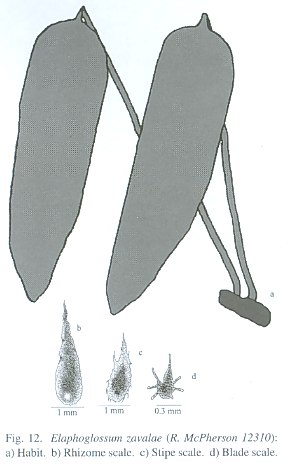
Terrestrial or epiphytic; rhizomes 3-6 mm diam., short to long-creeping, dorsiventral; rhizome scales 3-10 x 1-2 mm, ovate to linear-lanceolate, orange-yellowish with blackish central zone, light, dull, dense, margins entire; phyllopodia distinct, 10-35 mm long; fronds 20-46 (-62) cm long, spaced 0.3-1.0 cm apart; stipes (1/5) 1/3-1/2 of the frond length; basal stipe scales 3-5 mm long, gradually reduced to 1 mm near to apex of stipe, yellow-orange to blackish, with small irregular teeth; blades 15- 26 (-38) x (3-) 4.5-7 cm, elliptic to lanceolate, coriaceous, base cuneate to obtuse, apex acute to acuminate; blade scales sparse, minute, stellate with blackish central body; basal costal scales to 1 mm; veins obscure to evident, free, simple to 2-forked, ca. 1 mm. apart, diverging at 60-70° angle from costa; hydathodes lacking; fertile fronds 20-62 cm long; stipes 2/5-2/3 of the frond length; blades 12-20 x 2.2-5.5 cm, lanceolate to elliptic, base narrowly to broadly cuneate, apex acute; intersporangial scales lacking.
Distribution: Panama; in Cordillera de Talamanca at 1850-2100 m.
Paratypes: PANAMA. Chiriquí: Monte Azul, 1.4 mi N of Entre Ríos on E slopes of Cerro Punta, T. Antonio 2724 (MO).
Elaphoglossum zavalae resembles E. coriifolium Mickel in its short-creeping rhizome and blade shape, but its rhizomes are thicker (4-6 mm diam. vs. 2-3 mm), rhizome scales are longer (3-10 mm vs. 4-6 mm), orange (vs. blackish) and entire (vs. dentate), and the fertile fronds are similar to sterile fronds (vs. the sterile fronds longer and wider). This species is very similar to E. lingua in size and blade shape, but differs in having thicker rhizomes (3-6 mm vs. 1.5-3 mm), yellowish (vs. black-ish) and longer (3-10 mm vs. 1-2 mm) rhizome scales, longer fronds (20-62 cm vs. 12-34 cm), and fertile fronds equal to sterile fronds (vs.sterile fronds shorter than fertile fronds). This species is dedicated to José Alejandro Zavala Hurtado, adviser in my doctoral thesis, ecologist investigator in the University Autónoma Metropolitana.
SPECIES ENMENDED AND RANGE EXTENSION
Elaphoglossum latifolium (Sw.) J. Sm., London J. Bot. 1: 197. 1842. Acrostichum lati-folium Sw., Prodr. 128. 1788. Type: Jamaica, Swartz s. n. (Holotype: S).
Distribution: Jamaica, Puerto Rico and Virgin Islands, at 450-1700 m. ]]>
On this species has been included very species as complex group, consequently, has been necessary to separate the others species for clarificated the taxonomy. The species more related to this species are: E. sartorii, E. viride and E. variabile; E. sartorii is basically terrestrial and with ascending rhizomes (vs. epiphytic and with short-creeping rhizomes), E. variabile present compact rhizomes and verticillate fronds (vs. short-creeping rhizomes and dorsiventral fronds), and E. viride have shorter stipe [1/3-2/5 vs. 1/6-1/4 (-1/3) of frond length], lanceolate blade (vs. elliptic) and narrower (2.5-3.7 cm vs. 4-9 cm) blades.Acrostichum sartorii Liebm., Mexic. Bregn. 166 (seors. 14). 1849. Type: MEXICO. Veracruz: Hacienda El Mirador, Liebmann (Pl. Mex. 2430, 2752, 2753; Fl. Mex. 12, 14, 660, 661, 662) (Type: C-n.s.; Cotype: K!).
Elaphoglossum scapellum (Kunze ex Fée) T. Moore, Index Fil. 365. 1862. Acrostichum scapellum Kunze ex Fée, Mém. Foug. 9: 1. 1857. Tipo: México, Veracruz, Galeotti 6304 (P-n.s.; photo F!).
Elaphoglossum subarborescens Rosenst., Repert. Spec. Nov. Regni Veg. 4: 295. 1907. Type: Brasil, S. Paulo, Serra do Mar, Wacket s. n. (BM-n.s.).
Distribution: Previously known from México, "Venezuela" and "Brazil", but now also from Guatemala, Honduras, El Salvador, Costa Rica and Panama. Present in all wet forest at (700-) 1300-2000 (-2700) m. Material of new distribution: GUATEMALA. Alta Verapaz: Cobán, 4300 ft., H. Türckheim 995 (UC). Baja Verapaz: N of Divide N of Santa Rosa, about 1650 m, P. Standley 69904 (F). Jalapa: Volcán Jumay, N of Ja-lapa, 1300 m, J. Steyermark 32474 (F). HONDURAS. Intibucá: Mpio. Yamaranquila, 4.4 mi. SW of La Esperanza, along road from La Esperanza to Camasca, 1870 m, muestra mixta con E. muscosum, G. Davidse et al. 35215A (MEXU). Francisco Morazán: Montaña La Tigra, 2000 m, H. Laínez 9 (MO, TEFH); drainage of the Río Yeguare, at about 14° N, 87° W, A. Molina 4082 (US); 20 km E de Tegucigalpa, Montaña La Tigra, 1400 m, C. Nelson et al. 3886 (MO, TEFH). Ocotepeque: El Portillo, on Cordillera Merendón, 20 km from Nueva Ocotepeque, 1800 m, A. Molina 23313 (F). EL SALVADOR. Volcán San Vicente, Pico W, 2000 m, R. Seiler 327 (F). COSTA RICA. Cartago: Santa Clara de Cartago, 1750 m, W. Maxon & A. Harvey 8244 (US). Puntarenas: Buenos Aires, Cuenca Térraba-Sierpe, Estación Tres Colinas, 9°0744" N, 83°0358" W, 1940 m, E. Alfaro 686 (INB, MO); Coto Brus, Cuenca Térraba, Sierpe, Zona Protectora Las Tablas, Cerro Pando, 8°5404" N, 82°4500" W, 1960 m, E. Alfaro et al. 919 (INB, MO); a los pies de la Cordillera de Talamanca, alrededor de Tres Colinas, 9°07 N, 83°04 W, 1800-1850 m, G. Davidse et al. 25610 (CR, MO); Cerro Pando, Coto Brus, Zona Protectora Las Tablas, Cuenca Térraba Sierpe, Zona Protectora Las Tablas, Finca La Neblina, Finca de William Gamboa, 8°5417" N, 82°4503" W, 2050 m, B. Gamboa 1141 (INB, MO); sobre el Río Burú, 2010 m, L. Gómez et al. 21462 (CR, MO, NY); Upper Río Burú, 2010 m, L. Gómez et al. 21790 (CR, MO, NY, UC); Coto Brus, Las Mellizas, cabecera de Río Negro, 8°5530" N, 82°4540" W, 1800-2300 m, G. Herrera 3394 (CR, INB, MO, NY); Coto Brus, Parque Internacional La Amistad, Cordillera de Talamanca, Cerro Gemelo, sendero entre sitio de acampar y Cerro Gemelo, 9°0255" N, 82°5555" W, 2200-2700 m, M. Moraga & A. Rojas 457 (CR, INB, MO, NY, UC, US); Cantón de Coto Brus, Parque Internacional La Amistad, Cuenca Térraba-Sierpe, Estación Pittier, zona de acampar, 9°0220" N, 82°5650" W, 2040-2300 m, M. Moraga & A. Rojas 509 (CR, INB, MO, NY, UC); Coto Brus, Zona Protectora Las Tablas, Cordillera de Talamanca, Quijada del Diablo, Mellizas, 8°5350" N, 82°4520" W, 1860 m, E. Navarro 393 (INB, MO); Maíz de Boruca, 700 m, R. Ocampo 1976 (CR, MO); Parque Internacional La Amistad, Coto Brus, Cordillera de Talamanca, sendero a Valle del Silencio, entre la zona de acampar y la Estación Casacoca, 9°0715" N, 82°5750" W, 1800-2500 m, F. Quesada et al. 1471 (CR, INB, MO, NY, US, UC); Zona Protectora Las Tablas, Coto Brus, Cordillera de Talamanca, Sabalito, Las Alturas de Cotón, Estación Biológica Las Alturas, sendero a Cerro Echandi, postes 20-29, 8°5820" N, 82°5005" W, 1800-2020 m, A. Rojas 776 (CR, INB, MO, NY); Parque Internacional La Amistad, Coto Brus, Cafrosa, 8°5440" N, 82°4719" W, 1200 m, J. Saborío 60 (CR). San José: Escazú, Zona Protectora Cerros de Escazú, Cerros Escazú-La Carpintera, Cerro Cedral, 9°5138" N, 84°0802" W, 2000 m, J. Morales 3267 (INB, MO); Aserrí, Cerros Escazú- La Carpintera, Tarbaca, El Cedral, camino a Pico Alto, 9°4935" N, 84°0650" W, 1770-2000 m, A. Rojas & M. Ovando 2621 (CR, INB, MO, NY, UC, US, MEXU, K, F); carretera de La Sierra a San Cristóbal Sur, 1 a 2 km de La Sierra, 1900 m, J. Utley & K. Utley 3058 (CR, F); Pérez Zeledón, Parque Nacional Chirripó, Cordillera de Talamanca, San Gerardo, Camino a Cerro Chirripó, inicios de la cuesta El Termómetro, 9°2815" N, 83°3510" W, 1100 m, A. Rojas & B. Gamboa 2934 (CR, INB, NY); near Laguna de La Escuadra, NE of El Copey, 2000-2200 m, P. Standley 42029 (US), P. Standley 42052 (US), P. Standley 42068 (US); El Copey, Talamanca ridge near Interamerican Hwy., 6 mi. E of Santa María de Dota, H. Stork 1600 (UC). PANAMA Chiriquí: Cerro Punta, orilla del río, 2000 m, R. Caballero 148 (PMA, MO, US); between Bambito and Cerro Punta, T. Croat 10576 (MEXU); a lo largo de la orilla del bosque sobre el jardín de plantas en la terminación de la carretera sobre el tanque de agua I.D.A.A.N. en Cerro Punta, 700 m, T. Croat 26328 (MO); vecindades de Monte Azul, 1.4 mi. N de Entre Ríos, en laderas al E de Cerro Punta, 3 mi. por carretera del pueblo de Cerro Punta, 2250 m, T. Croat 48618 (MO); Bajo Chorro, 1000-2000 m, DArcy 10922 (MO); along Guillermo Trail, Horqueta Mountains, above El Boquete, 1675-1735 m, E. Killip 5097 (US); valley of the Río Caldera, from El Boquete to the Cordillera, 1400-1600 m, E. Killip 5179 (US); El Respingo, Cerro Punta, B. Lara & S. Chavarría 36 (MO); vicinity of Camp Aguacatal, eastern slope of Chiriquí Volcano, 2100-2300 m, W. Maxon 5284 (US); El Respingo, Cerro Punta, A. Saavedra 24 (US); Wof Río Caldera, ca. 2 km NW of Bajo Mono (Boquete Region), 8°49 N, 82°28 W, ca. 1700 m, A. Smith et al. 2470 (UC); Boquete, Fortuna Dam Site, along trail following conti-nental divide, 1100 m, H. Werff & Hardeveld 6694 (MO,UC); Bugaba, Santa Clara, 8°50 N, 82°44 W, 1300 m, H. Werff & J. Herrera 7115 (MO, UC); Volcán de Chiriquí, vecindades Casita Alta, 1500-2000 m, R. Woodson et al. 838 (MO, US). Elaphoglossum sartorii resembles E. latifolium in long and orange-reddish rhizome scales, but differs in having compact to very short-creeping (vs. short-creeping) rhizomes, shorter (2-5 (-7) mm vs. 4-9 mm) and dark brown to blackish (vs. orange-reddish to brown) rhizome scales, and dark brown to blackish (vs. orange-reddish to brown) costa and blade scales.
The material from high elevations with short-creeping rhizomes and rhizome scales with a blackish central zone, determined as this species, corresponds to E. longistipitatum A. Rojas; the material with concolorous rhizome scales, narrowly elliptic blades, blackish costa and blade scales belongs to E. clewellianum; and the material with dense and longer rhizome scales, and bigger blades corresponds to E. andicol a. E. sartorii has been confused with E. viride wish have short-creeping rizome, rare and present in Sierra Madre Oriental and Sierra de Juárez (Oaxaca, Puebla and Veracruz), but the typical E sartorii have elliptic blade and abaxial blade scales yellowish, more distributed in neotropical wet forest.
]]>
Elaphoglossum andicola (Fée) T. Moore, Index Fil. 5. 1857. Acrostichum andicola Fée, Mém. Foug., Hist. Acrostich. 2: 28, t. 2, F. 1. 1845.
Distribution: Previously known from Colombia, Ecuador, Peru and Bolivia, but now also from Costa Rica. Present in Cordillera de Talamanca and central portion of Atlantic slopes of Cordillera de Los Andes at 1900-3400 m
Material of new distribution: COSTA RICA. Puntarenas: Coto Brus, Sabalito, Zona
Protectora Tablas, Sitio Tablas, Sendero Surá, 8°5710" N, 82°4505" W, 1950-2050 m, E.
Navarro & A. Rojas s. n. (INB, CR, NY).
Elaphoglossum andicola resembles E. lankesteri Mickel in its short-creeping rhizomes, frond size and elliptic blades, but differs in having longer (10-15 mm vs. 4-10 mm) rhizome scales, longer (1/3-1/2 of frond length vs. 1/4-1/3) stipes, thickly coriaceous (vs.chartaceous to subcoriaceous) blades, narrowly cuneate to attenuate (vs. obtuse to narrowly cuneate) blades base, and blackish (vs. orange-yellowish to brown) blade scales. It is also similar to E. latifolium, but differs in having bigger (10-15 x 0.8-1.5 mm vs. 4-9 x 0.5- 1.0 mm) rhizome scales, longer (65-102 cm vs. 30-70 cm) fronds, longer [1/3-1/2 of frond length vs 1/6-1/4 (-1/3)] stipes, and blackish (vs. orange-reddish to brown-yellowish) abaxial blade scales.
]]>
Acrostichum sporadolepis Kunze ex Kuhn, Linnaea 36: 59. 1869. Type: Venezuela, Fendler 294 (MO!).
Distribution: Previously known from Venezuela, French Guiana and Brazil, but now also from Costa Rica, Panama . Present in Cordillera de Talamanca, northern region of Cordillera de Los Andes, Cordillera de Mérida and Cordillera de la Costa at 2200-2850 m.
Material of new distribution: COSTA RICA. Limón: Talamanca, Parque Internacional La Amistad, Cordillera de Talamanca, Valle del Silencio, sobre el sendero, 9°0715" N, 82°5755" W, 2450 m, M. Moraga et al. 302 (CR, INB, MO, NY, UC, US). Puntarenas: Coto Brus, Parque Internacional La Amistad, Cordillera de Talamanca, Cerro Pittier, sendero entre Cerro Gemelo y Cerro Pittier, 9°0345" N, 82°5615" W, 2700-2850 m, M. Moraga & A. Rojas 443 (CR, INB). PANAMA. Chiriquí: Monte Azul, 1.4 mi N of Entre Ríos on slopes of Cerro Punta, 3 mi by road from town of Cerro Punta, 2250 m, T. Antonio 2741 (MO); 0.8 km up the main road from the center of the town of Cerro Punta, then 1.2. km SW along side road, on ridge beyond end of the road, 2100-2300 m, D. Lellinger et al. 1940 (US); Cerro Punta, Parque Internacional La Amistad, Estación Pilas, sendero retoño, 2200-2250 m, A. Rojas et al. 3324 (INB, MO, PMA).
Elaphoglossum sporadolepis resembles E. lankesteri in its short-creeping rhizomes, frond size and elliptic blades, but differs in having longer (1/3-1/2 of frond length vs. 1/4-1/3) stipes, very coriaceous (vs. chartaceous to subcoriaceous) blades, and orange-yellowish (vs. brown) blade scales. It is also similar to E. andicola (Fée) T. Moore, but differs in having bigger (15-22 x 1-3 mm vs. 7-18 x 0.8-1.5 mm) and orange-yellowish (vs. orange-yellowish to blackish) rhizome scales, cuneate (vs. narrowly cuneate to attenuate) blade base, and orange-yellowish (vs. black-ish) blade scales.
This work has been possible thanks to the agreement between INBio-SINAC. To the herbaria for the specimens loans, to Teresa Terrazas for the critical revision, to Robbin C. Moran, Daniel Tejero and anonyms revisors for their help, to Alan R. Smith for help with the abstract and introduction, to Francisco Quesada for the scales illustrations; and to all who, in one way or another, made this work possible.
Resumen
Doce especies son descritas en el taxonómicamente difícil complejo Elaphoglossum latifolium (Sw.) J. Sm. (sect. Elaphoglossu m): Elaphoglossum angustifrons A. Rojas, E. delgadilloanum A. Rojas, E. ellipticifolium A. Rojas, E. incognitum A. Rojas, E. mesoamericanum A. Rojas, E. nicaraguense A. Rojas, E. polypodium A. Rojas, E. tejeroanum A. Rojas, E. reptans A. Rojas, E. terrestre A. Rojas, E. variabile A. Rojas y E. zavale A. Rojas. También E. latifolium (Sw.) J. Sm. Y E. sartorii (Liebm.) Mickel son corregidos, E. andicola (Fée) T. Moore y E. sporadolepis (Kunze ex Kuhn) T. Moore son informadas.
References
Gómez, L.D. 1986. Plantae Mesoamericanae novae. Phytologia 60: 73-76. [ Links ]
Mickel, J.T. 1980. Nine new Elaphoglossums (Elaphoglossaceae) from Mexico. Brittonia 32: 334-339. [ Links ]
Mickel, J.T. 1981. Elaphoglossum, pp. 104-116. In A.R. Smith. Pteridophytes & D.E. Breedlove (eds.). Flora of Chiapas 2. Calif. Acad. Sci. California, USA.
Mickel, J.T. 1987. New species of Elaphoglossum (Elaphoglossaceae) from northern South America. Brittonia 39: 313-339. [ Links ]
Mickel, J.T. 1990. Three new species of Elaphoglossum from Peru. Amer. Fern J. 80: 110-112. [ Links ]
Mickel, J.T. 1991. Elaphoglossum. In R.M. Tryon & R.G. Stolze. Pteridophyta of Peru. Part IV. 17. Dryopteridaceae. Fieldiana, Bot, n.s. 27: 111-166. [ Links ]
Mickel, J.T. 1992a. New species of the fern genus Elaphoglossum from Mesoamerica. Novon 2: 368-382. [ Links ]
Mickel, J.T. 1992b. Elaphoglossum, pp. 266-281. In R. McVaugh (ed.). Flora Novo-Galiciana. Vol. 17. Gymnosperms and Pteridophytes. Michigan, USA.
Mickel, J.T. 1993. Six new species of Elaphoglossum (Elaphoglossaceae). Brittonia 45: 213-218. [ Links ]
Mickel, J.T. 1995. Elaphoglossum, pp. 250-283. In R.C. Moran & R. Riba (eds.). Flora Mesoamericana. Volumen 1. Psilotaceae a Salviniaceae. Universidad Nacional Autónoma de México. México, D. F.
Mickel, J.T. & J.M. Beitel. 1988. Pteridophyte Flora of Oaxaca, Mexico. Mem. New York Bot. Gard. 46: 168-186. [ Links ]
Proctor, G. 1989. Ferns of Puerto Rico and the Virgin Islands. Mem. New York Bot. Gard. 53: 289-301. [ Links ]
Rojas-Alvarado, A.F. 1996. Twelve new species of Elaphoglossum (Elaphoglossaceae) from Costa Rica and Panama. Brenesia 45-46: 7-26. [ Links ]
Rojas-Alvarado, A.F. 1997. Fourteen new species of Elaphoglossum (Elaphoglossaceae) from Meso-america. Brenesia 47-48: 1-16. [ Links ]
Rojas-Alvarado, A.F. 2002. New species, new combinations and new distributions in neotropical species of Elaphoglossum (Lomariopsidaceae). Rev. Biol. Trop. 50(3-4): 969-1006. [ Links ]
Smith, A.R. 1975. New species and new combinations of ferns from Chiapas, Mexico. Proc. Calif. Acad. Sci. 40: 220. [ Links ]
Internet References
Anonymous. 2002. Index Herbariorum. The New York Botanical Garden. (Downloaded: April 5, 2002. http://www.nybg.org/bsci/ih/) .
1 Coordinación de docencia y atención a alumnos, División de Ciencias Biológicas y de la Salud, Universidad Autónoma Metropolitana, sede Iztapalapa, Av. Michoacán y La Purísima s. n., Col. Vicentina, 09340, México, D. F.; afrojasa@hotmail.com
2 Instituto Nacional de Biodiversidad, Apdo. 22-3100, Sto. Domingo, Heredia, Costa Rica. ]]>