


 text in
  English (pdf)
 Article in xml format
 Article references
 Send this article by e-mail
 Cited by SciELO
  Similars in
SciELO
Similars in
SciELO 
 Permalink
INTRODUCTION
Coastal zones are areas with widely varying socio-natural dynamics, where the characterization of land cover and its transformations over time give us information about the socioeconomic activities that take place in these spaces (Rujoiu-Mare & Mihai, 2016) as well as about the environmental problems they present. It is important to establish the difference between land cover and land use because, according to Mather (1986) and Pineda and Principi (2019), these terms are commonly confused. Land cover refers to the physical description of the surface of the earth, which includes vegetation, areas without vegetation and human zones; land use, for its part, refers to the characterization of current human activities, focusing on socioeconomic factors that modify, manage, preserve and use different types of land cover (Ramírez, 2001; Richters, 1995).
This distinction makes it possible to establish spatial relationships in different areas between the use and exploitation of coastal areas and natural transformations of the environment, which is the subject of the present study, which investigates land cover and its changes in coastal erosion hot spots in the southern Caribbean of Costa Rica. Information on the relationship between land cover and coastal erosive processes makes it possible to establish the degree of impacts on human activities associated with the dynamics of changes in land cover. These processes involve both natural and social interactions, with social factors generating more accelerated modifications over time, changing slightly transformed environments into more artificial spaces.
Coastal zones or littoral areas are a strip resulting from the interaction between nature and human activities influenced by the sea (Barragan, 2003). These areas can be broken down into biophysical, socioeconomic and legal-administrative subsystems, and present a series of particular problems. From a biophysical perspective, changes in the shoreline cause problems including loss of sediments from beaches, salinization of coastal wetlands, death of coastal vegetation, and sedimentation of seagrasses and reefs. In the socioeconomic subsystem, changes in the coastline can affect residential use, increase sedimentation in ports, modify fishing and tourist activities and transform the coastal landscape, among other effects. In terms of the legal-administrative subsystem, it is necessary to consider the content of Costa Rica’s Law 6043 on the Maritime Terrestrial Zone, which establishes static limits to an area that is undergoing strong transformations, such as, retreating beaches, which can lead to legal uncertainty about the granting of concessions in restricted areas. The southern Caribbean coastal area of Costa Rica has great natural wealth, including lagoons, estuaries, mangroves and coral reefs; likewise, coastal land has been occupied by ports, berths, and coastal communities, used for fishing and associated tourist services, and has many natural and cultural resources; however, these areas are also often characterized by significant lags in development and poverty. This particular combination of characteristics is the reason why the coastal area was selected as the subject of the present study.
Together, factors such as the relative rise in mean sea level related to climate change and local geodynamics (uplift or subsidence of the land), as well as other causes more directly related to human actions, such as the filling of coastlines, construction of infrastructure along the coast, changes in drainage basins, and the construction of dams can alter the sediment balance necessary to maintain beaches (Posada & Henao, 2008), leading to the erosion of sandy beaches.
Changes in land cover are the result of a synergy between multiple endogenous and exogenous factors interacting at different levels, and are related to environmental, economic, population and public policy changes (Nene Preciado, González Sansón, Mendoza Cantú, & Silva Bátiz, 2017). In the specific case of coastal areas, the interaction of natural and social components make this one of the most fragile environments in the terrestrial habitat, where important transformations take place due to growth in road construction, residential infrastructure, and production systems which promote coastal erosion processes. According to Silva et al., (2014), coastal erosion is not a general problem in Latin America, but is widespread and may have serious effects in certain locations, affecting infrastructure in areas where natural uses previously predominated.
These conditions are reflected in coastal areas, which are subject to continuous increases in human activities that generate greater pressures and needs for places to locate infrastructure, in some cases in unsuitable areas. According to Merlotto and Bértola (2008), as changes and alteration in the natural environment take place, the absorption capacity of the natural environment is reduced and pre-existing balances are altered. Identification of the processes of changes in land cover over time can be linked to the processes of coastal erosion. These processes affect each other; on the one hand, promoting changes in land cover and, on the other hand, upsetting the balance of sediments on sandy beaches.
In the case of the Costa Rican southern Caribbean coast, Lizano (2013) reports erosion processes on beaches in protected areas and coastal tourist sites, which strongly affect the Cahuita National Park, with land previously covered by forest being occupied by beaches or the sea (La Nación, 2010). This research is based on the work carried out by Barrantes, Arozarena, Sandoval and Valverde (2020), which reported the existence of 11 coastal erosion hot spots (coastal sites where accelerated erosion rates are registered) in the southern Caribbean. The present research aims to characterize land cover in these sites and its changes on the coast, to better understand the link between these two processes during the 2005-2017 period.
METHODOLOGY
Study area
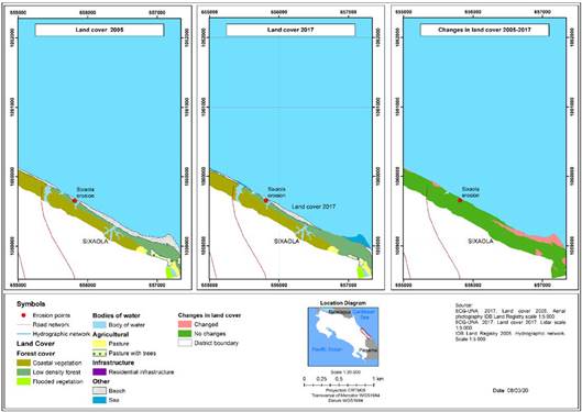
Costa Rica is a Central American country with coasts on the Pacific Ocean and the Caribbean Sea. The Caribbean coast has an approximate extension of 220 km, only one-fifth the length of the Pacific coast (Vargas, 2006), due, on one hand, to the borders established with Nicaragua to the north and Panama to the south, as well as a straighter coast on the Caribbean side. The study area is located in the province of Limón, running from the city of Limón (to the south of the city’s urban center) to the mouth of the Sixaola River (on the border with Panama). It is located between the following geographical coordinates: -83.034864 W, -82.564229 W, 9.993417 N and 9.570096 N (Figure 1),
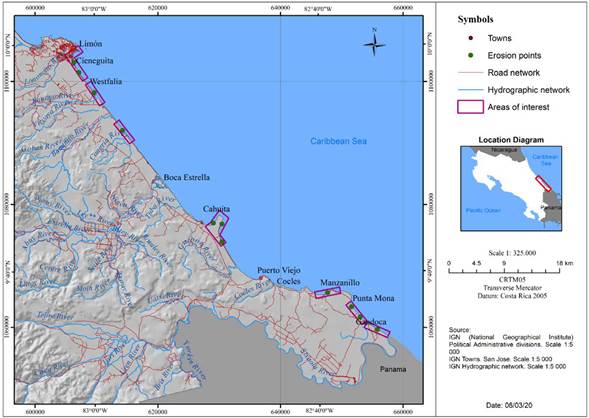
and covers the coastline of the districts of Limón, Matina, Valle de la Estrella, Cahuita and Sixaola. It is important to highlight the presence of protected areas in this region, such as the Cahuita National Park, the Gandoca-Manzanillo Wildlife Refuge, and the Keköldi Indigenous People’s Reserve, as well as the presence of the mouths of important rivers such as the Banano, Estrella and Sixaola.
The study area encompasses a 200 m wide strip along the coastline, which roughly coincides with the restricted area established in Law 6043 on the Maritime Terrestrial Zone defined as: “a two hundred meters wide strip along the entire Caribbean and Pacific coastlines of the Republic, whatever their nature, measured horizontally from the high tide line.”
The climate on the Caribbean coast does not have a defined dry season, but rather two periods in which rainfall decreases, the first from February to March and the second between September and October (IMN, 2017). Herrera (1986) classifies the southern Caribbean climate as hot humid with a short dry season.
Methodological process
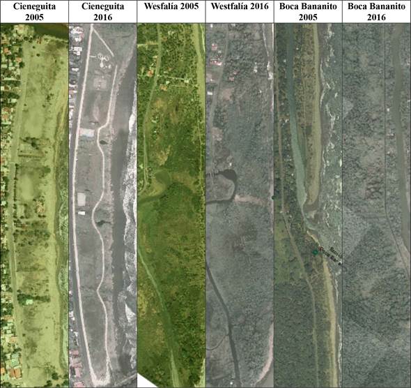
To define the area to be studied, the critical points for coastal erosion identified in the southern Caribbean of Costa Rica during the 2005-2016 period were used as a reference (Barrantes et al., 2020). According to these authors, the critical sites are: a) Cieneguita, b) Airport, c) Wesfalia, d) Cahuita, e) Puerto Vargas, f) Manzanillo and g) Sixaola (Figure 1). For the generation of land cover layers in shapefile format, two sources of information were used: A mosaic of orthophotos for the year 2005 at a scale of 1: 5 000, with a spatial resolution of 0.5 m (from the BID-Cadastre project), and orthophotos for the year 2016 at a scale of 1: 1 000, with spatial resolution of 0.1 m, that belong to the National Emergencies Commission (CNE). The information provided had already undergone orthorectification, so the present study focused on the stages of photointerpretation, digitization through ArcGis software and field verification in December 2017. The land cover categories defined from the orthophotos are presented and defined in Table 1.
Since the purpose of this research is to characterize changes in land cover in relation to the erosive processes that were recorded, a work area of 200 m from the coastline inland was defined, for the purpose of temporal comparisons. For the purpose of generalizations, the coverage classes were grouped into two categories: Natural (N) and Non-natural (NN).
Photointerpretation and digitization of the land cover categories were carried out using ArcGIS software, with the attribute table structured in terms of fields for use and hectares for 2005 and 2017. These data facilitated the creation of maps to numerically calculate surfaces for each year.
Table 1 Definition of land cover categories.
| General categories | Characterization |
|---|---|
| High density forest (Natural) | Forest ecosystems characterized by an abundant canopy that limits light penetration in the herbaceous and shrub stratum, which show only a limited presence of anthropic activity, are identified in the images as areas with high canopy density. |
| Low density forest (natural) | Forests that show strong human intervention, followed by natural regeneration processes after the primary forest has been totally or selectively eliminated by anthropic activities or natural events. |
| Regenerating forest (natural) | Areas in the process of natural regeneration after the primary forest has been totally or selectively eliminated by anthropic activities or natural events. |
| Coastal vegetation (natural) | Vegetation typical of the transition zone between an aquatic environment and a terrestrial environment. |
| Flooded vegetation (natural) | Occurs in flat places where soils are saturated for several months of the year due to high rainfall. |
| Body of water (natural) | Surface covered by water both naturally and artificially. |
| Pasture (Not natural) | Partial removal (less than 50%) of trees and replacement by grass due to anthropic activities, especially extensive cattle ranching. |
| Crops (Not natural) | Areas with agricultural activities that can be permanent or seasonal. |
| Urban - dispersed infrastructure (not natural) | Characterized by urban-residential occupation, accompanied by institutional, industrial, commercial and recreational public services such as plazas, as well as the presence of spatially dispersed residences. |
| Beach (Natural) | Area of accumulation of sand and other sediments in seas, rivers and lakes, with a flat surface or with a slight slope. |
| Sea (Natural) | Mass of salty water that covers part of the earth’s surface. |
Source: Adapted from Morera and Sandoval (2013).

Changes in land cover between 2005 and 2017 were represented based on the assignment of weights or codes (Table 2), which allowed their differentiation and facilitated recording the changes that occurred through time. For example: a category for the use of flooded vegetation for the year 2005 was assigned a value of 1 and a value of 600 was assigned to the category of use of pasture for the year 2017. When a change of use occurred involving these two categories, an algebraic sum of maps was calculated (adding the tables of both layers), and the result was 601 (Table 2), which indicates that an area was previously categorized as flooded vegetation, but later became covered with grass.
RESULTS
Land cover in the southern Caribbean of Costa Rica 2005 - 2017
Cieneguita-Airport Sector
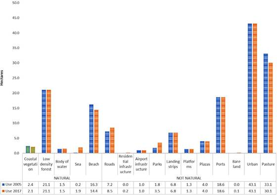
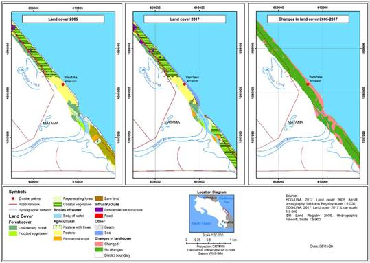
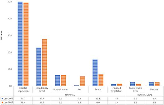
In the Cieneguita-Airport sector, natural cover in 2005 consisted of: low density forest (21 ha), coastal vegetation (2.41 ha), body of water (1.45 ha), sea (0.18 ha) and beach (16.25 ha). An analysis shows significant changes in the surface areas of the beach and sea categories, with total beach area decreasing by 1.84 ha and the total area of the sea increasing by 1.76 ha. From these data it is possible to conclude that most of the beach loss is related to an advance of the sea towards land (Figure 3 and Graph 1).
In 2005, there was 117 ha (74%) of land classified as “not natural,” where human activities were include; the total area of not natural land had increased by 0.29 ha in the year 2017, an increase related to recreational spaces such as parks and courts (1.72 ha), residences (0.17 ha) and roads (1.3 ha) on land previously occupied by beaches. This change in land cover was the result of an attempt to reactivate the area economically, with an investment of around 2 million dollars for the construction of a boulevard, small plazas, a bicycle lane, playing fields and areas for children’s games by the central government (Mora, 2015). However, these works, as well as houses facing the sea, were being affected by severe waves just one year after their inauguration (Bosque, 2016a).
From the data provided by Barrantes et al. (2020) it is estimated that the erosion rate in this sector for the 2005 - 2016 period was 0.39 ha / year, which is reflected in the data presented here and in the construction of mitigation measures to protect the exposed works (Figure 2), as well as the placement of a stone dam to protect the Cieneguita bike path.
Westfalia sector
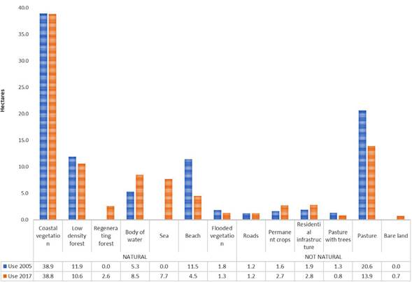
The sector of Westfalia has an area of 96 ha; 69 ha (70%) of this area had natural cover in the year 2005 which increased to 74 ha (77%) for the year 2017. The natural categories that had decreased in area in 2017 were low density forest (by 1.3 ha), flooded vegetation (by 0.5 ha) and especially beaches (by 7 ha) (Graph 2); on the other hand, coastal vegetation (by 0.1 ha), regenerating forest (by 2.6 ha), bodies of water (by 3.2 ha) and the sea (by 7.7 ha) increased in area. In this sector, the beach seems once again to be being replaced mainly by the sea (5.7 ha), but several other types of land cover also increased in total area, including regenerating forest (2.6 ha), coastal vegetation (0.04 ha), bare land 0.07 (ha) and pasture (0.04 ha).
In the case of non-natural types of land cover, there was an increase in permanent crops, going from 1.6 ha (2005) to 2.7 ha in the year 2017, while residential infrastructure, which covered an area of 1.9 ha in the year 2005 and 2.8 ha in the year 2017. However, it is important to highlight the pasture reduction by 6.7 ha during the study period, which primarily changed to the sea

(figure 4). This retreat of pastures and beaches is in accordance with what was reported by Barrantes et al. (2018); from their data, the
Generated during the investigation.
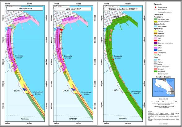
Figure 3 Cieneguita-Airport Sector: Land cover and changes during the 2005-2017 period.
Source: Prepared by the authors based on land cover data during the 2005 - 2017 period, generated during the investigation.
Graph 2 Westfalia Sector: Land cover during the 2005-2017 period.
erosion rate in the sector is estimated at 0.56 ha /year, higher than in the case of Cieneguita-Aeropuerto, which according to these same authors is due to the migration of the mouth of the Banano River during the study period.
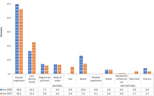
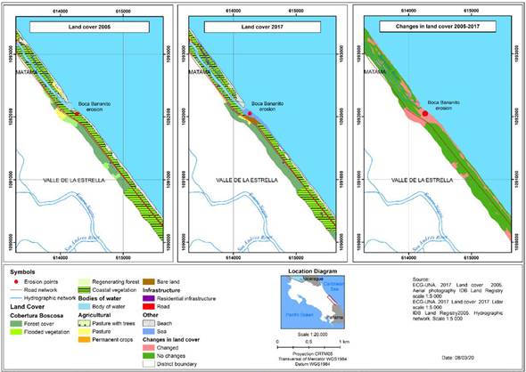
Bananito sector
For natural land cover in the Bananito sector in the year 2005, coastal vegetation cover predominated with a total area of 49.8 ha, followed by low-density forest (16.3 ha), and beaches with 13 ha (Graph 3). All natural surfaces showed a reduction during the study period except for low-density forest, which increased from 16.3 ha in 2005 to 22.5 ha in 2017, with the increase occurring mainly behind the coastal road (towards the land) (Figure 6). In the case of the beach category, its area decreased by 5% (5 ha), a change which was associated with the dynamics of the mouth of the Bananito River. With regard to anthropic activities, there was a slight increase in residential infrastructure, from 0.3 ha in 2005 to 0.6 ha in 2017, while the area covered by road infrastructure remained constant (Graph 3).
According to Barrantes et al. (2020), changes in the mouth of the Banano River are important in this sector, since the direction of coastal currents in the Caribbean (Lizano, 2018) caused erosion of the left bank of the river mouth and accumulation of sediments on the right bank, leading to the reinforcement of the road to prevent its destruction. As a result of these changes, coastal vegetation, bare
Generated during the investigation.
Figure 4 Westfalia Sector: Land cover and changes during the 2005 - 2017 period.
Source: Prepared by the authors based on land cover data during the 2005 - 2017 period. generated during the investigation.
Graph 3 Bananito Sector: Land cover during the 2005 - 2017 period.
land and beaches decreased in area as the area covered by sea increased (Figure 6). However, beaches also decreased in area as a result of increases in the coastal vegetation that grows on the sandy bar north of the river mouth (Figure 5).
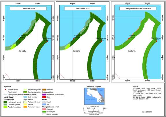
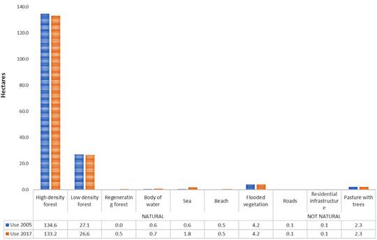
Cahuita Sector-Puerto Vargas
Land cover for the Cahuita-Puerto Vargas sector is characterized by the predominance of natural cover throughout the study area. As can be seen in Graph 4, the area covered by high-density forest decreased by 1.4 ha during the study period, while the area covered by low-density forest
Made from a mosaic of orthophotos from 2005 at a scale of 1: 5 000, with a spatial resolution of 0.5 meters (from the National Registry), 2) Orthophotos from 2016 at 1: 1 000 scale, with a spatial resolution of 0.1 m (property of the National Emergency Commission (CNE)).
Figure 5 Changes in land cover according to aerial photography 2005-2016.
Generated during the investigation.
Figure 6 Bananito Sector: Land cover and changes during the 2005-2017 period.
decreased by 0.5 ha. Most of the decrease in high-density forest is due to increases in the area covered by the sea, showing an accelerated retreat of the shoreline in this sector (Barrantes et al., 2018) (Figure 7). On the other hand, there was a slight increase in the area occupied by beaches (in 0.1 ha) which, according to Barrantes et al. (2018) is the result of the accretion (growth of beaches and other forms of coastal accumulation) of a small segment of beach located to the northeast of the point of greatest erosion (Figure 8).
Taken in the field on December 6, 2017.
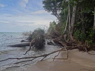
Figure 7 Cahuita-Puerto Vargas Sector: Forest cover affected by coastal erosion.
As can be seen in Graph 4, the area of residential infrastructure increased slightly, going from 0.084 ha to 0.129 ha. It is important to emphasize the impact of severe waves on infrastructure, which led the park administration to relocate its house and office, as can be seen in the remains left where the old building was located; likewise, sections of the trail within the park disappeared, which led to its relocation (Soto, 2014). According to the data presented by Barrantes et al. (2020), the average erosion rate in the sector is estimated to be 0.46 ha / year, a figure that is considered intense.
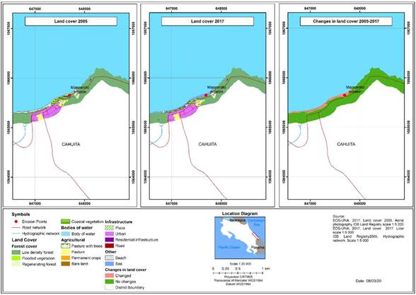
Manzanillo sector
The distribution of land cover in Manzanillo shows a predominance of natural cover: 85.6 ha in the year 2005 and 86.4 ha in the year 2017. As shown in Graph 5, there was a significant increase in the area occupied by the sea at the expense of areas of low-density forest (0.08 ha), areas of natural regeneration (0.04 ha), and, most notably, beaches (4.2 ha). The area covered by beaches shows a significant decrease between 2005 and 2017, going from 5.8 ha to 1.5 ha, as the area covered by the sea increased substantially (4.1 ha), and the area covered by coastal vegetation increased slightly (0.29 ha ) (Figure 9). An average erosion rate for this sector of 0.12 ha / year was estimated based on the data presented by (Barrantes et al. 2020), which is considered to be mild, due to the size of the sector.
Generated during the investigation.
Figure 8 Cahuita-Puerto Vargas Sector: Land cover and changes during the 2005-2017 period.

Source: Prepared by the authors based on land cover data during the 2005-2017 period, generated during the investigation.
Graph 4 Cahuita-Puerto Vargas Sector: Land cover during the 2005 - 2017 period.
Source: Prepared by the authors based on land cover data during the 2005 - 2017 period, generated during the investigation.
Graph 5 Manzanillo Sector: Land cover during the 2005 - 2017 period.
In the case of anthropic coverage, a slight increase in residential infrastructure was observed, from 0.2 ha in the year 2005 to 0.3 ha for the year 2017, together with a reduction in the area covered by pasture which was 4.6 ha in 2005 and 3.9 ha in 2017 (Graph 6), which contributed to the increase in area covered by low-density forest and residential infrastructure.
Sixaola sector
Barrantes et al. (2020) identified three hot spots of erosion in Gandoca, one of them near the mouth of the Sixaola riv-er. When comparing changes in land cov-er, there is evidence of a marked decrease of the area covered by beaches between 2005 and 2017, to 6.9 ha (Graph 6). This reduction in the surface is associated with an increase in the area of the covers such as sea (5.2 ha) and low-density forest (3.8 ha) (Figure 10). The rest of the covers showed little change.
It is important to note that a significant part of the loss of beach cover is related to the disappearance of the accumulated sand bank on the Costa Rican bank of the Six-aola River. This bank is possibly composed of beach ridges characteristic of a previous process of progradation (growth towards the sea of a delta or coastal plain) of this important river system.
Generated during the investigation.
Figure 9 Manzanillo Sector: Land cover and changes during the 2005-2017 period.
Source: Prepared by the authors based on land cover data during the 2005-2017 period, generated during the investigation.
Graph 6 Sixaola Sector: Land cover during the 2005-2017 period.
DISCUSSION OF RESULTS
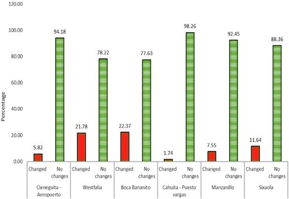
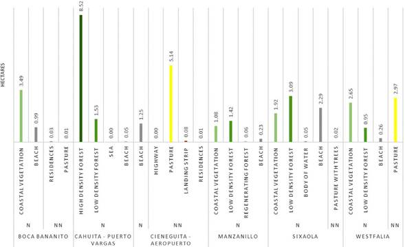
In general terms, based on the analysis carried out in each sector (Graph 7), it is clear that the largest changes in land cover occur at the mouth of the Bananito River and in Westfalia. When comparing the 2005 land cover map with the areas eroded between 2005-2016, reported by Barrantes et al. (2020), it was found that areas in the Bananito sector, surfaces mainly associated with coastal vegetation (3.49 ha), beaches (0.99 ha) (which formed part of sand bars) and grass (0.01 ha) and residential infrastructure (0.03 ha) were lost (Graph 8), while in Westfalia mainly coastal vegetation (2.65 ha), grass (2.97 ha), forest (0.95 ha) and beach (0.26 ha) were lost.
In second place, images suggest that the Sixaola sector experienced a change in morphodynamic behavior from progradation to erosion of the sand banks that are located on the sides of the river mouth, and increases between 2005-2017 in areas covered by the sea, resulting in a reduction of beaches by 2.29 ha, coastal vegetation by 1.92 ha and low-density forest by 3.09 ha (Graph 8). When comparing areas that were affected by erosion processes between 2005 and 2016, there is evidence of a greater impact on the natural covers that are part of the pioneer vegetation that populates these environments.
Next, Manzanillo is protected from the direct impact of waves by the presence of a reef, but there was a significant loss of beach in a small sector. As shown in Graph 8,
Source: Prepared by the authors based on land cover data during the 2005 - 2017 period. Generated during the investigation.
Graph 7 Changes in land cover by erosion sectors South Caribbean, period 2005-2017.
0.23 ha of beach was lost to erosion between 2005 and 2016, which also affected 1.08 ha of coastal vegetation and 1.42 ha of low-density forest.
In the penultimate position is the Cieneguita-Airport sector. According to Barrantes et al. (2018), the most likely cause of changes in land cover in this sector is the existence of a breakwater located in Cieneguita beach that retains sediments from the Limoncito river. In this sector, decreases natural covers such as beaches (0.05 ha) have occurred. In addition, when comparing the land cover in 2005 with the coastal erosion that occurred between 2005 and 2016, a direct impact on decreases in the areas of cover types such as residences (0.01 ha), runway (0.08 ha) and pastures (5.14 ha) can be detected. According to Bosque (2016b), the community was affected by a landward advance of the sea over beaches of between 30 and 60 meters between 2014 and 2015. These facts highlight the level of risk of the infrastructure developed in this sector in the face of coastal erosion that removes the sand from its foundations and, on occasions, floods the new boulevard (Arguedas, 2017) due to severe waves or extraordinary tides.
Finally, Cahuita shows the least change during the period studied, although it is pronounced in small forested areas which recede in front of the sea, which can be seen by comparing the land cover for the year 2005 with the study by Barrantes et al. (2020) on critical beaches in terms of coastal erosion in 2005 and 2016, in which the main coverage affected by these processes was found to be forest, which lost 8.52 ha.
In Manzanillo, the areas with the greatest decreases in area are protected
Note: N: Natural; NN: Not natural. Prepared by the authors based on other mosaics from 2005 and 2016, updated with field work in 2017.
Graph 8 Land cover in 2005 affected by erosion between 2005 and 2016.
from direct waves by a reef (Barrantes et. Al., 2018). However, according to the newspaper article by Soto (2014), in the last 15 years the Cahuita National Park lost 20 meters of beach due to coastal erosion, a situation that directly affects species such as turtles (Baula, Verde and Carey) which find less space for egg laying, and decreases camping space for tourists due to the retreat and decrease in the width of the beaches.
The above findings are consistent with those of Luijendijk et al. (2018) who analyzed erosion of sandy beaches around the world and found that most sandy coastlines in protected areas are being eroded. This situation was also evident in the southern Caribbean of Costa Rica, where its two marine protected areas showed significant processes of retreat of the shoreline, affecting the resources and services that these areas offer for the livelihood of local communities.
CONCLUSIONS
In the southern Caribbean of Costa Rica there are areas with accelerated coastal erosion, or “erosion hotspots,” in which landscape transformations have taken place that can be evaluated in terms of changes in land covert. In the case of natural cover, erosion reported in these areas has caused losses of beaches, grasslands and coastal vegetation, and even of forest, while the area covered by the sea has increased, likewise effects on urban covert have been reported in Cieneguita and Manzanillo.
Changes in land cover for the Cieneguita-Airport sector indicate an increase in urban coverage related to the construction of a boulevard and recreational infrastructure. These uses have increased the risk of coastal erosion and loss of public goods. Once again, a loss of natural covers such as beaches, grasses and coastal vegetation in favor of the sea has taken place as the sea encroaches on the land.
In Westfalia, pastures which were close to the beach and the beaches themselves lost the greatest areas to the advancing sea, followed by low-density forest. However, the areas of some types of cover such as regenerating forest, coastal vegetation and bare land, are increasing as a result of the silting up of parts of the old river mouth.
In Bananito, the greatest changes in coverage were decreased areas of beach and coastal vegetation balanced by increased areas covered by the sea, and land denuded by the action of waves on the coast. Likewise, part of the regenerating vegetation on the sand bar that is growing at the river mouth is coastal vegetation.
In the Cahuita sector there has been a loss of high-density forest (which is not coastal vegetation) and a small area of low-density forest which has been replaced by the sea, as well as an increase in regenerating forest and a small area of beach where the coastline is advancing towards the sea (accretion). Regarding human use, there is a slight increase in residential infrastructure which has been affected by erosive processes that led to the relocation of trails and other infrastructure for tourist activity, leaving behind indications of their previous locations.
In the Manzanillo sector, the main change in coverage has been the loss of beaches to the sea, leading to an effort to increase the coverage of coastal vegetation on the coastline to protect the town from severe waves. Likewise, there has been a slight increase in residential infrastructure, a process that increases risks in the sector.
The sector at the mouth of the Sixaola River experienced a strong decrease in the area of beaches, and to a lesser degree of pasture with trees. In the first case this was due to the reduction of sandbanks on the right bank of the river and in the second case the change was due to an increase in low-density forest vegetation.
The effects of coastal erosion that occurred between 2005 and 2016, reported for critical points of coastal erosion in the southern Caribbean of Costa Rica, have produced changes in land cover. For the most part, beaches, pasture and coastal vegetation are the type of land cover most affected by encroachment of the sea. In the particular case of Punta Cahuita, high- and low-density forest vegetation is retreating in front of the sea despite being sheltered by a coral reef and being within a protected area.

