


Servicios Personalizados
Revista
Articulo
 texto en
  Inglés (pdf)
 Articulo en XML
 Referencias del artículo
 Enviar articulo por email
Indicadores
-
 Citado por SciELO
 -
 Accesos
Links relacionados
-
 Similares en
SciELO
Similares en
SciELO
Compartir

 Permalink
Revista Geográfica de América Central
versión On-line ISSN 2215-2563versión impresa ISSN 1011-484X
Rev. Geog. Amer. Central no.68 Heredia ene./jun. 2022
http://dx.doi.org/10.15359/rgac.68-1.5
Artilte
Impact on urban form of the new Social Housing projects developed in Costa Rica
1
 http://orcid.org/0000-0002-6841-5953
2
http://orcid.org/0000-0002-6067-4854
3
http://orcid.org/0000-0001-9262-5013
4
http://orcid.org/0000-0002-6743-6664
1Escuela de Arquitectura, Universidad de Costa Rica. Email: helga.vonbreymann@ucr.ac.cr
2 Arquitecta. Escuela de Arquitectura, Universidad de Costa Rica. Email: valeria.chacon@ucr.ac.cr
3 Arquitecto. Escuela de Arquitectura, Universidad de Costa Rica. Email: mauricio.ramirezramirez@ucr.
4 Arquitecta. Escuela de Arquitectura, Universidad de Costa Rica. Email: lucia.rodriguezramirez@ucr.ac.cr
5 Arquitecta. Escuela de Arquitectura, Universidad de Costa Rica. Email: paola.rojasalvarez@ucr.ac.cr
6 Arquitecto. Escuela de Arquitectura, Universidad de Costa Rica. Email: andres.morasandoval@ucr.ac.cr
In Costa Rica, the social housing (VIS) projects developed in the last decade have been located in areas far from urban centers of limited access to facilities and infrastructure due to the prohibitive cost of land ownership in most central sectors of metropolitan cities. The conditions and characteristics of these contexts, available land uses (zoning), morphological configurations, continuity and contiguity between social housing projects and the urban pieces where they are inserted, are analyzed in this research through the study of five residential complexes developed in the Greater Metropolitan Area of Costa Rica. The projects, built between 2011 and 2018, were analyzed from the study of construction plans, cartography of the area, documentary review and analysis of secondary data. From the obtained results it is possible to identify the main difficulties arising from the morphological and typological fit that followed after the establishment of the residential complexes, as well as the contextual problems derived from the location of the projects.
Keywords: Urban configuration; Residential complexes; Urban morphology; Urban planning; Social Housing.
INTRODUCTION
In recent years, many of the so-called social housing projects (VIS) in Costa Rica were built in areas lacking in infrastructure and urban facilities due to the difficulty of accessing cheap land in the most central sectors of the city. This has supposed disadvantageous conditions for these residential complexes and thus limited the opportunities of their residents to access goods and services commensurate with daily life and to secure a good quality of life.
The study of urban morphology emerges as a theoretical-methodological approach that enables a greater understanding of the implications of urban form and its effects on the social dimension. The limited diversity in land uses, the absence of continuity in the urban layout or the existence of barriers are just some of the manifestations that are evidenced when there are flaws in the morphological fit of new pieces within existing and poorly balanced urban frameworks, developed without adequate urban planning and control.
In Costa Rica, the development of Social Housing involves various actors, primarily developers ―who assume the task of planning and developing the residential complexes― and the Banco Hipotecario para la Vivienda (BANHVI) (translated as Mortgage Bank for Housing), a government banking institution which reviews, finances and supervises the execution of said residential projects.
Land selection for the construction of houses is carried out by developers and the government counterpart (government institutions) verifies the compliance of technical requirements. This methodology has made possible the development of new decontextualized public housing developments suffering from significant deficiencies. The selection of the land not only lacks clear procedures but is also based on inadequate basic technical requirements with deficient criteria that do not include substantial elements to ensure access to some services and infrastructure necessary for providing the residents of said projects with a good quality of life.
Furthermore, there is an important void in the procedures that would allow the execution of typologically congruent developments and in consonance with the urban landscape of the context in which they are developed, which is generating important fractures in the continuity, legibility and urban landscape of many sectors of cities.
In light of this, the morphological study of the urban pieces where VIS projects are inserted is revealing and allows the formulation of strategies that favor a better urban-architectural articulation to improve the quality of life its inhabitants, key aspect in understanding the dialectic between physical space and society, as stated by Halbach in his writings on social morphology (Martínez, 2003).
Following Capel (2002), urban morphology and the built environment reflect the social and economic organization, as well as the political structures of the dominant social groups. Therefore, the analysis of urban structure, its arrangement, connections, typologies, etc., are key to understanding the complexity of urban environments. Functional problems in certain city environments manifest the weaknesses entailed in the organization of forms and urban management processes, and reinforce the need for a dynamic and global approach to the environment and forms (Munizaga, 2000).
In line with this argument, the location of tertiary economic activities, and mainly, their territorial extension as pointed out by Christaller (1933), are also determining factors in understanding the dynamics of the city and its layout.
To embark on the subject matter from the urban design perspective, as proposed for several decades by authors such as Christopher Alexander (1964) with the study of complexity and urban relations, or Fumihiko Maki (1964) through the understanding of the various modes of aggregation or association of urban forms, has enabled a better comprehension of the effects of morphological elements in the development of cities.
Other approximations, such as that of Oliveira (2013), seek to assess the maturity of urban processes, for which they combine accessibility variables such as spatial accessibility of the street system, year of construction of buildings, parcel density, alignment of buildings, the dimension of street blocks, the ratio between height of buildings and street width, and the uses given to the buildings. Regardless of how it is approached, this type of analysis has been able to demonstrate that both urban variety, as well as the location of infrastructure, services, commerce, etc., in the territory, are fundamental for the provision of spatial conditions necessary for a good quality of life of its residents (González, 2000).
In Costa Rica, studies on urban morphology are scarce, however contributions have been made from the disciplines of geography and history by way of analysis of the evolution of the urban structure and its link with productive transformations (Quesada, 2014); the urban hierarchy of urban cores (Hall, 1974); the impact upon the urban layout with regard to the perception of security and coexistence relations (Barrantes, 2019); and other more concrete contributions on specific neighborhoods, such as the study by Gómez, Guillén and Salas (2018) carried out to understand the evolution and transformation of the urban layout and the dynamics of a central neighborhood in Costa Rica.
Based on the above, the objective of the present study is to evaluate, from a morphological approach, the urban and typological fabric of the surroundings in which social housing projects are located, based on the analysis of five cases developed in the Greater Metropolitan Area (GMA) of Costa Rica in recent years.
The study allows to advance evidence regarding urban practices related to the development of VIS, through complementary diagnoses and analyses, to enable the promotion of procedures for improving the location, configuration and fit of these projects within the surrounding urban pieces where they are constructed.
METHODOLOGY
The research was based on the case study methodology. Five Social Housing projects, located in different districts of the Greater Metropolitan Area (GMA) of Costa Rica, were selected possessing different characteristics. The five projects were analyzed in terms of the impact of their location on the surroundings and the effects of urban layout on the project. The study is of descriptive-analytical nature and is prepared from documentary review and cartographic, planimetric and photographic analysis of the selected geographical areas.
The procedure for the study was structured from the analysis of three basic elements of morphological studies, namely: typology and urban structure, land use and analysis of the continuity of the urban layout (Capel, 2002). Hence, a survey of the following morphological elements was developed at the meso and micro levels:
Services, land endowments destined for public use and public facilities, and main infrastructure.
Main roads network, hierarchy and connectivity.
Green areas, urban forests and vacant areas.
Layout of parcels and building typologies.
At the meso level, the urban context within a radius of 1 kilometer from the project was analyzed as this was considered an accessible distance for the entire population. The proximity, connectivity and structure of the urban fabric of the locations were studied to understand the context in which these urban pieces are inserted. At the micro level, the urban piece of each residential complex and its immediate context were evaluated to observe in greater detail aspects of morphology, project typology and fit, while considering existing aspects of continuity and contiguity.
Once the information had been collected and registered through the creation of various maps, an analysis was carried out and the five case studies were compared, from which conclusions and recommendations were drawn for consideration.
Case studies
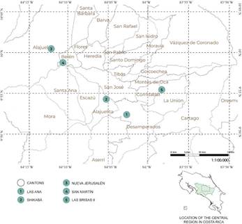
The selected case studies are located in the Greater Metropolitan Area of Costa Rica (see map 1), a geographical area that concentrates over 52,7% of Costa Rica’s population (INEC, 2011); the corresponding VIS projects were constructed between the years 2011 and 2018. Case selection took into consideration the residential typologies of the projects, the quantity of constructed houses, and geographical location, seeking to adequately represent the urbanistic diversity existing across the entire Greater Metropolitan Area.
In the following section, the five selected case studies are presented and their geographical contextualization reviewed, followed by an analysis of the morphological elements of the urban context of their localities.
Las Anas Residential Project
The Las Anas is a Social Housing Condominium located in sector 4 of the district of Los Guido, in the canton of Desamparados, province of San José. Desamparados is one of the most densely populated cantons in the Greater Metropolitan Area and is home to a large number of social housing projects and several informal settlements. The Los Guido district accelerated its urbanization process starting in 1986, during the first presidency of Oscar Arias, mainly due to the creation of the government aid program “Bono de Familia” (translated as Family Bond), and resulted in the development of a significant number of VISs in this sector. The aid program provided housing opportunities to foreign and national families from all over the country, who lived in poverty and lacked access to housing and basic services.
The Las Anas Condominium, completed in 2018, was carried out by the Fundación Promotora de Vivienda (FUPROVI). The project was proposed with the aim of eradicating the Las Palmas informal settlement, thus providing housing for a total of 198 families in dire need.
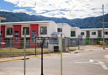
Source: FUPROVI (Fundación Promotora de Vivienda, translated as Housing Promotion Foundation).
Figure 1 Photograph of Las Anas Condominium.
From the cartographic analysis of the existing urban development in the area, it stands out that the growth of the sector has been taking place irregularly over a mostly flat territory. An urban layout following a specific pattern was not initially defined, instead the layout was constructed spontaneously as the population expanded. A road hierarchy is identified and reflected in the two main roads that cross and give access to the district (see Map 2) and from which stem secondary roads that provide limited redundancy. The two primary axes provide continuity in mobility and access to the city center of Desamparados, located at a distance of 5.3 km. A homogeneous division into blocks is not identified, although rectangular blocks prevail and the division into small-size lots with residential typologies of one or two-level single-family housing dominate.
Regarding land use, residential use predominates and a significant variety of commerce and services buildings are observed. Within a radius of 1000 meters from the project, other basic facilities such as educational centers, health centers, churches and recreational parks are located. According to the Zoning Ordinance Plan (known in Costa Rica as Plan Regulador) of the Municipality of Desamparados (Municipalidad de Desamparados, n.d.), the area where the project is located is classified as Low Density Residential Zone and existing green and recreational areas belong to a Forest Protection Zone.
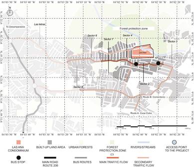
Source: Own elaboration from satellite images.
Map 2 Surroundings of the Las Anas Residential Project.
The project consists of 73 two-level buildings, distributed in 37 lots and has two outdoor recreational spaces (i.e., green and recreational areas) and a commercial zone. Each lot corresponds to a residential condominium with an average area of 480 m2; all condominiums are connected by public roads, forming a condominium housing complex with only one access point. Each condominium is comprised of an average of five houses and three parking spaces.
In general, the housing solutions present the same programmatic characteristics, although organized in four different residential typologies: 47.5 m2 single-family house (two bedrooms), 54.9 m2 single-family house (three bedrooms), 56.5 m2 single-family house (two bedrooms, designed for people with disabilities) and a 64.3 m2 single-family house (three bedrooms, designed for people with disabilities).
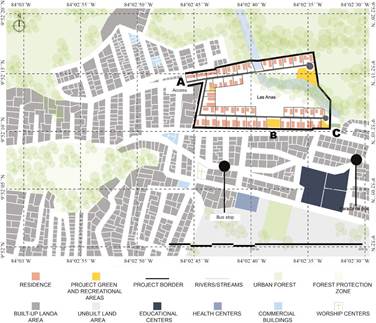
Source: Own elaboration from satellite images.
Map 3 Immediate context and distribution of the Las Anas Residential Project.
In terms of connectivity and contiguity, the project has a single restricted access point (sector A) (see Map 3). The entire perimeter is delimited by a wall, which restricts accessibility and connection with the exterior. Despite the latter characteristics, the project has two sectors that could be enabled as access points (see Map 3, sectors B and C).
The housing project is crossed by a stream, which generates a green corridor and establishes a direct connection with the natural environment that surrounds the land plot. It is a resource that allows aperture of the project to its context and creates a break in the project’s landscape and form, as it divides the project in two. It constitutes a vegetation barrier, running south to north, that serves as the prelude to the protected forest zone located at the north backend of the project. Scenically, the barrier is a grand void that engulfs practically half of the project’s land plot. At the meso scale, this void functions as a separating element between the housing complex and the city center (i.e., downtown Desamparados).
Internally, the project breaks with the irregular morphology of the surrounding sector, as it presents an orderly arrangement of houses and also, because it is comprised of condominiums that follow a disposition, both physical and functional. There is no clear contiguity with the adjacent sectors.
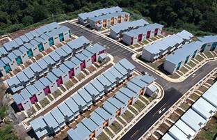
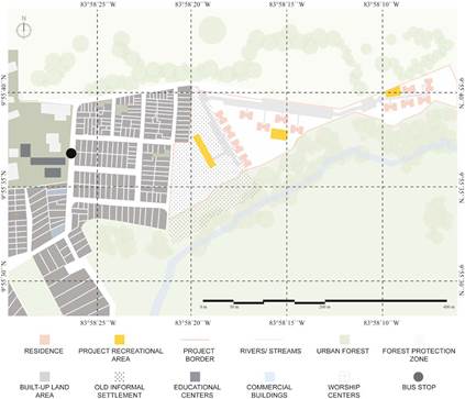
Shikaba Residential Project
The Shikaba Residential Complex is a Social Housing (VIS) project, developed under the figure of a housing complex by the developer FUPROVI, which benefited 254 low-income families living in extreme poverty. It is located in the Alajuelita district, of the Alajuelita canton, province of San José. It was completed in 2019 but as a result of bureaucratic delays and the public health emergency caused by COVID-19, the project was delivered a year later, in December 2020. Similar in outcome to the Los Guido district, the appearance of the “Bono de Familia” government aid program in the 1980s, saw Alajuelita become one of the cantons with the greatest development of social housing projects.
The accelerated arrival of socioeconomically vulnerable populations and the lack of urban planning caused, over time, a stark segregation that had an impact on urban transformation.
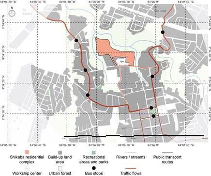
The urban layout of downtown Alajuelita is regular, however as one moves north towards the project it turns more irregular. Furthermore, in the sector where Shikaba is located, a small-size parcel composition can be identified with limited presence of large-size plots. The project is surrounded by the Tiribí River to the north, La Guaria Stream to the west and the Mancha Stream to the east. The south side leads to the only access road and adjoins the informal settlements of Juan Pablo II and La Deportiva, erected since 1982 and 1997, respectively.
The district has a main access road which connects with the Anillo de Circunvalación, a main peripheral vehicular highway system connecting with the capital city of San José (see Map 4). This peripheral system constitutes at the same time an important physical border at the pedestrian level by virtue of narrow sidewalks of less than 1.5 meters wide, few pedestrian bridges, insufficient urban furniture and vegetation, all negatively affecting pedestrian connectivity. The access road to the project also connects directly with the district’s main highway on the east and south sectors, but lacks connection with the west sector of San Felipe de Alajuelita, due to the absence of road infrastructure over the La Guaria Stream thus affecting the accessibility and proximity to services found in the western sector (see Map 5).
Regarding the land use of the studied area, within a radius of 1000 meters the project is provided with essential utilities and services, as well as high schools and health centers. Land use is primarily residential with one or two-level single-family houses.
Source: Own elaboration from satellite images.
Map 4 Surroundings of the Shikaba Residential Complex.
The housing complex is made up of 244 single-family houses erected using a masonry construction system with concrete blocks and offered in six different typologies: Type 1 is a two-level construction with an area of 53 m2 (two bedrooms), Type 2 is two-level and 54.4 m2 (two bedrooms), Type 3 is two-level and 65.2 m2 (three bedrooms), Type 4 is two-level and 63.3 m2 (three bedrooms), Type 5 is one-level and 52 m2 (two bedrooms, designed for people with disabilities) and Type 6 is two-level and 71.1 m2 (two bedrooms, adapted for the elderly).
Within the bounds of the housing complex, the design contemplated a parking lot, five playground areas for children, three communal facilities, 29 residential-commercial mixed-use lots, 215 residential-use lots, as well as a vast park area to be reforested, which adjoin the protection zones of the Tiribí River and La Guaria and Mancha Streams.
Source: Own elaboration from satellite images.
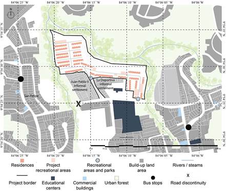
Map 5 Immediate context and distribution of the Shikaba Residential Complex.
The design of the housing complex responds to the optimization of space in an irregular shaped lot by fitting the greatest possible number of houses and realizing the reforestation of common areas and parks adjacent to the protected area along the banks of the river and streams. The presence of both streams and the Tiribí River define the topographic characteristics of the site. This is located on a terrain with a steep slope to the north created by the presence of the river, while the west and east sides are both embraced by streams that create less pronounced slopes. These bodies of water and the vegetation cover enrich the housing complex with a natural border that separates it from its surroundings. In addition, the distribution of the houses by rows is highly contrasting and breaks with the irregularity of the urban fabric, thus the project is perceived even more detached from its immediate context.
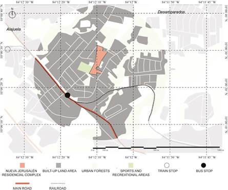
Nueva Jerusalén Residential Project
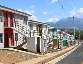
The Nueva Jerusalén Residential Project is located in the Desamparados district of the Alajuela canton, province of Alajuela. The project is located in an urbanized area 2.5 km from downtown Alajuela. The project was developed by the company Construcciones Modulares de Costa Rica S.A., during 2011, with the aim of eradicating an informal settlement installed on the same land plot, thus providing new housing for 56 families.
Source: Colegio Federado de Ingenieros y Arquitectos, 2013.
Figure 3 Photograph of the Nueva Jerusalén Residential Project.
Historically, this area has been mostly of residential use, a situation that has changed little to date. The main changes, in terms of the morphological elements of the area, respond to an increase in housing density mainly due to a slight increase in the built-up land footprint.
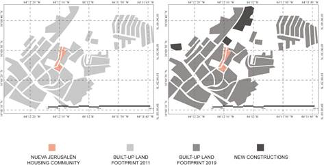
Map 6 Analysis of the built-up land footprint and vacant areas in the immediate context of the Nueva Jerusalén Residential Project.
The topography of the Desamparados district is regular, although it exhibits some slopes associated with the course of some rivers, which have been decisive in the configuration of the access roads to this sector.
From the study of the morphological configuration of the site, it is observed that it is quite irregular (see map 7), in contrast to the distinctive squared urban grid of downtown Alajuela. At the district level, the absence of planning prohibited the expansion of the regular urban fabric starting from orthogonal blocks, but rather gave way to an irregular development of small-size parcels, linked to road axes of low hierarchy and to multiple agricultural zones interspersed within new urbanized pieces.
Source: Own elaboration from satellite images
Map 7 Surroundings of the Nueva Jerusalén Residential Complex.
The zoning in this area is primarily residential, exhibiting mostly one-level buildings, nonetheless, the vicinity also presents some agricultural land use zones. Its strategic location has influenced the nearby availability of urban facilities and urban services such as worship centers, sports, health and educational facilities. At a greater distance, the urban city center of Alajuela offers parks, commerce, cultural spaces and other services.
The project was developed adjacent to a major road axis, which connects the center of the consolidated city of Alajuela with other main cities such as Heredia and San José.
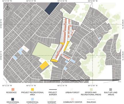
Regarding the configuration of the project, a main road axis that crosses from north to south is identified, which, in turn, connects with the “Pasito” public road through a street and a non-vehicular avenue (in Spanish “alameda”) existing on the site (see Map 8).
Despite the project’s strategic location, connecting axes only exist on the east side, although most of the nearby goods and services are found in the Southwest sector, thus supposing a poor integration and limited accessibility. The lack of road redundancy and the project’s configuration hinder the continuity and contiguity of the residential complex with the surrounding area, limiting access to some of the basic needs of its inhabitants.
Source: Own elaboration from satellite images.
Map 8 Immediate context and distribution of the Nueva Jerusalén Residential Complex.
Regarding the project, it consists of 11,984.5 square meters, accommodating 56 houses of 44.1 square meters each. Their typology corresponds to one-level, semi-detached houses, distributed in four blocks. The residential complex has green areas and playgrounds, as well as space for communal facilities. The project does not break with the morphological irregularity of its immediate context and maintains its distribution as small-size parcels, which are not regular, throughout the project.
San Martín Residential Project
San Martín Condominium is located in the San Antonio district of the Belén canton, province of Heredia. It is comprised of 40 houses and was developed to provide housing for the families of the community of Belén, who were being affected by the overflow of the Quebrada Seca River and landslide events that occurred in the hill slope of the sector known locally as the La Ribera de Belén. This project was developed by Construcciones Modulares S.A., in 2015, who constructed one and two-level single-family houses under the figure of a condominium.
The urban center of the canton of Belén has an unconventional layout due to its elongated configuration. It is made up of rectangular blocks wherein are located the church and central square, crossed by primary roads, in an east-west direction, and by secondary roads from north to south. The structures of the initial layout have coexisted with subsequent planned layouts, maintaining a certain balance between old and new geometries. This grid is quickly lost when moving away from the urban center and, although San Martín Condominium is located within this centric high-density area, its shape is not the traditional quadrant.
Regarding land use, this sector being centric is characterized by possessing mixed-used zoning; it offers diversity of facilities, services, commerce and industry. In the vicinity of the project there are also care centers and educational centers of various types, and the protection zones of the Pirro River provide the sector with an extensive strip of green areas (see Map 9).
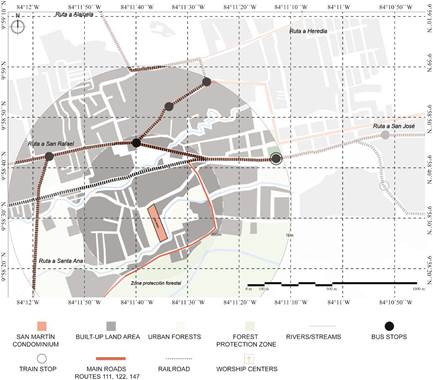
Source: Own elaboration from satellite images.
Map 9 Surroundings of the San Martín Residential Project.
The housing density around the project’s context has not been greatly altered in the past 10 years, incorporating only a few new housing developments in its surroundings. Nor have the road axes been modified, thus the morphology has undergone little transformation in the last decade. Namely, urban development has maintained continuity in terms of form, and the construction of the San Martín Condominium has not represented a break in that trend.
Secondary roads that branch off from the main axis are limited by the presence of the Pirro River and the irregular topography of the zone, which has conditioned the urban configurations developed in the area. These fluvial axes represent barriers in the urban continuity and contiguity of the sector. In addition, the irregularity of the roads that lead to different residential communities and condominiums in the area create limited road redundancy, affecting connectivity.
Source: Own elaboration from satellite images.
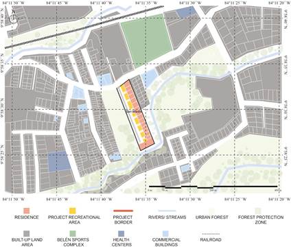
Map 10 Immediate context and distribution of the San Martín Residential Project.
Regarding the design of the residential complex, it stands out that the houses are distributed in a linear manner, parallel to the main street within the complex which leads to and ends at the stream. The complex offers two play areas for children and only contemplates one type of house of 49.2 square meters and built using a masonry construction system.
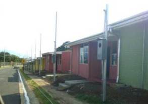
Las Brisas II Residential Project
Las Brisas II Condominium is located in the community of Dulce Nombre in the canton of La Unión, province of Cartago. The development of the project was undertaken by Fundación para la vivienda rural Costa Rica-Canada, which worked together with the Municipality of La Unión. This project is the result of the completion of the second stage of a larger project. The first stage was carried out between 2003-2008 and consisted of providing housing to 172 families residing in that area since 1989. These people came mainly from the sectors of Los Guido in Desamparados and El Alto del Carmen in Dulce Nombre de La Union.
In 2002, an informal settlement was erected in the project’s sector destined for the green and recreational areas. The second stage was proposed as a housing solution for those families who inhabited the informal settlement thus giving rise to the Las Brisas II Condominium Project. The project was completed in 2019 and provided housing to 156 families in dire need.
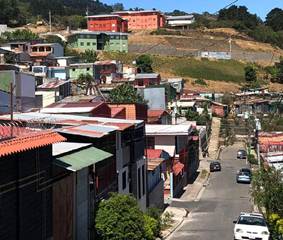
Source: Andrés Mora (2020).
Figure 6 Photograph of the immediate context of the Las Brisas II Condominium.
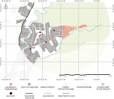
Based on a cartographic analysis, it is observed how the area where the project is located is characterized by having an irregular topography due to its proximity to the Central Mountain Range of Costa Rica, known locally as the Cordillera Central. Additionally, this sector has four natural borders: to the north it adjoins a Forest Protection Zone, to the east and south there exists an important depression towards the El Cantillo Stream, and to the west lies the Tiribí River which divides the neighborhood in two sections (see Map 11). Such conditions have affected the growth of the urban fabric, which has followed an irregular development. An initial urban layout was not defined, rather it was created on the go as the community grew.
An organized road hierarchy was identified initiating from a main axis that crosses the neighborhood from west to east, from which secondary roads are organized, thus creating poor road redundancy that limits the access to different services and commerce. This main axis permits traffic flow continuity to the main urban center of Tres Ríos, located at a distance of three kilometers.
This branched road configuration derived from the main axis, creates an irregular morphology, where small-size plots predominate, exhibiting residential typologies of one or two-levels, in accordance with municipal guidelines established in the Zoning Ordinance Plan (known in Costa Rica as Plan Regulador) for Low Density Residential Zone with slight urbanization activity.
Although few facilities are located within a radius of 1 km―educational, health and religious centers― it is notorious the absence of urban facilities such as public spaces, parks and recreational spaces. It is worth noting that, due to the steep slopes found throughout the different sectors of this area, accessible pedestrian mobility is quite limited for the entirety of its residents.
Source: Own elaboration from satellite images.
Map 11 Surroundings of the Las Brisas II Residential Project.
In terms of connectivity and contiguity, it stands out that the project has a perimeter fence and a single access, which connects it to the immediate context. Likewise, the irregular topography of the project’s sector creates a natural division with the rest of the neighborhood. The internal configuration of the project adapts to the natural topography of the site and its location on the hill endows the project with a dominance over the visual scenery and surrounding urban landscape.
Las Brisas II Condominium, being a housing complex located at a higher altitude and possessing a larger footprint, breaks with the continuance present in the zone and with the irregular morphology and small-sized plots characteristic of the neighborhood. Furthermore, due to the fact that it is a gated condominium, it interrupts the accessibility and connection to the rest of the surroundings, which reaffirms its condition of isolation or disconnection with its context.
Results
The analysis of the social housing projects selected for study showed relevant results, both individually and comparatively.
Following Lynch’s (1961) classifications, it is noticeable that most of the studied projects are located in dispersed sheet pattern surroundings with fine and irregular grain, with expansive growth towards the peripheries. It is recognized that, in terms of the morphological continuity of the contexts surrounding the projects, in the cases of Nueva Jerusalén and San Martín, their presence does not substantively modify the morphological structures already existing thereabout. It was possible to detect that they maintained pre-existing road axes and adapted to the urban grids of their immediate context, so that their development did not signify a major impact at the physical-spatial level. On the contrary, the Las Anas and Shikaba projects interrupt the existing urban layout with notable impacts on their contexts. The breakaway from the irregular structure pattern is mainly due to the insertion of large pieces possessing perimeter enclosures (i.e., walls and fences) and by virtue of the internal organization of the project itself, which contrasts with the surroundings.
In the case of the Las Brisas II Condominium, there is also no continuity given to the architectural language and urban form of the context where the project is inserted whilst the geographical features condition the possible connections with its surroundings. The housing typology is also a disruptive factor, as the project is organized from vertical housing cores that interrupt the one or two-level single-family house typology that already existed in the surroundings.
The interruptions generated at the morphological level respond mainly to three circumstances: 1. Specific requirements of the developments administered under the figure of a condominium complex, 2. The compulsory optimization of space given the different natural conditions of the sites and 3. The lack of planning relative to the contextual relationship of the project.
It is interesting to note that the projects that break the morphology of the immediate context are those located in neighborhoods that grew irregularly. There is an attempt to regulate morphology through urban designs that follow a structured logic instead of continuing the growth that was already taking place.
According to Roy (2013), this could respond to the view that the informal, within urban theory, is seen as deregulated or irregular. This idea of irregularity is influenced by an imaginary, conceived from the formal point of view, which turns the informal into something thought of as peripheral and secondary (Laguerre, 1994). This imaginary of illegality and of the survival of the poor and marginalized, makes neighborhoods that are conceived in this way, try to be “corrected”.
When assessing the contiguity of the urban structure, and mainly of the options and activities based on land uses, present in the study areas, it is possible to identify a notorious spatial segregation in several of the case studies, as well as elements that prevent an adequate connection between residential and mixed-use zones that offer a greater range of services and facilities. Most of the projects do not possess a diverse portfolio of activities within their immediate context; that is, there is a limitation of social, economic and urban activities. Indeed, an important pondering factor considered in the quality of urban life is the proximate access to basic services and facilities, taking into account access in terms of time, distance and quality (Agencia de Ecología Urbana de Barcelona, 2008).
Additionally, due to the treatment given to the borders of the projects, there is a negation of the external space, mainly brought upon by the walls and fences that surround the developments and the presence, in several projects, of a single access point. Neither of those features facilitate the possibility of residents walking to services and facilities which is important activity as it encourages social interaction and appreciation of the urban surroundings and promote increase participation, volunteering, social health and a sense of community (Pozueta, Lamiquíz & Porto, 2009).
Despite the fact that most of the residential complexes studied are located close to commercial points and main roads, their potential to merge with external social dynamics and development is lost. Also, the proximity to public transportation systems is affected by this morphological arrangement. Projects such as Las Anas, Nueva Jerusalén and Las Brisas II have few public transportation options for their residents to easily mobilize to commercial or recreational spaces.
The urbanization model under the figure of a gated community is generating a series of externalities, for example, the impact on road redundancy, reduction of public spaces, increased perception of insecurity and increased residential segregation (Pujol, Sánchez & Pérez, 2011; Barrantes, 2019).
Gehl (2010) highlights the importance of ‘soft edges’ between public and private space, as a space of opportunity to activate streets and sidewalks, which is where much of urban life takes place. From the study of these social housing (VIS) cases, it can be verified that urban problems derived from the developments of self-contained housing communities, so-called “gated communities”, vastly examined in middle and upper class socioeconomic contexts, are repeated in a similar manner in the analyzed social housing projects (i.e., low-income class); socio-spatial effects are also analogous.
From the analysis of plot subdivision, and therefore of the structure of land use, the study of construction elements themselves, as well as of the housing community and the distribution of services and infrastructure, it is evident that the models followed in the areas where public housing projects are being constructed, are inadequate and condemn the developments to probable deficiencies upon an increase in population density or expansion of residential areas, as well as a deterioration in the quality of life of its residents. The latter situations are consequences of the practiced subdivision of plots and the poor provision of infrastructure that condemn these areas almost exclusively to residential use.
The comparisons made on the changes at the morphological level created after the construction of the projects, revealed that these developments have not contributed to urban integration or contiguity, they have missed opportunities to improve the problems of socio-spatial segregation, and have increased traffic burden on the road system, without major contributions to its redundancy.
Conclusions
The findings of this investigation allow the promotion of reforms on the current procedures followed for the construction of social housing, especially to improve the articulation of such projects within the existing city and, therefore, the benefit the quality of life of its residents.
The designs of the studied projects do not propose strategies to promote greater heterogeneity in terms of services and commerce, but rather limit their land use to residential zones along with their mandatory recreational spaces. However, such ineffective characteristics respond to the demands of existing legal regulations, and the impossibility of promoting greater urban variety. Furthermore, the small size of the parcels existing in the sectors, also limit the options for services, commerce and facilities, thus affecting the urban variety.
The foregoing discussion highlights the importance of conducting more detailed studies in future contributions in this line of work, to identify the relationships among the size of parcels, land values and urban centralities of each sector. A greater analysis of the characteristics of the urban structure where the residential complexes are being inserted would facilitate projecting the possible development and diversification of activities within a given area.
The topographic and orographic characteristics of candidate construction sites must be evaluated in greater detail, it does not suffice to solve for the infrastructure of the housing complex and its adaptation to the surroundings. Existing natural elements create important barriers that affect urban continuity and contiguity and constitute conditioning factors for the type of growth and configuration of our cities, also affecting the way in which its inhabitants mobilize.
A greater analysis of road axes from a transport-oriented development approach would make possible a better understanding of the areas of growth and expansion where such high densely populated projects, and the required accompanying infrastructure, should be located. Adequate project siting can translate in reduced transportation costs and greater accessibility to facilities.
It is important to contemplate the needs of the neighborhoods and its residents as early as the planning and design stages of the projects, and to allow for spaces that promote commerce in its different manifestations, while admitting diversification of activities within urban spaces as it is recognized that modern cities benefit from these multiplicities and heterogeneities (Roy, 2013).
The results of our analyses suggest that the government institutions and private companies commanding the development of social housing, continue to design based on a model of self-contained housing communities (gated communities) which keep residential complexes and their inhabitants isolated from the context. The projects are not having a positive impact on their surroundings due to the absence of an integral continuity that would support the creation of activities to diversify the dynamics of the context.
According to Jiménez (2017), in recent decades, Costa Rica has been implementing a city archetype that has fragmented the urban space, promoted segregation and increased social inequalities.
In line with the teachings of Capel (2002), the morphological study can have important repercussions on normative aspects, because “…the design of the city can be improved from the morphological analysis by better understanding the behavior of the component elements and the processes of transformation of the city” (p.22).
In this sense, the active participation of the municipalities, on account of their Zoning Ordinance Plans, becomes essential for approaching these social housing projects, as they determine factors that can translate into a good quality of life. Further, Harvey (2014) argues that changes and improvements in urban infrastructure executed exclusively by contractors will, in most cases, be governed by specific purposes that gravitate around maximizing economic revenues by the commercialization of lots, and may not necessarily have the true well-being of the project’s inhabitants in mind.
In conclusion, the study highlights the need to carry out comprehensive work between the private sector, foundations, BANHVI, INVU, project residents and local governments (i.e., municipalities), to ensure that social housing projects have permeable designs that avoid the promotion of physical and social segregation in the territories where they are located.
Municipal Zoning Ordinance Plans should contemplate the layout of new elements, providing instructions so that the site is configured in such a way as to ensure the adequate integration with the built environment and maximize comfort, security and attractiveness (Pozueta, Lamiquíz & Porto, 2009).
Considering the socioeconomic situation of the residents of these types of projects, it seems necessary to include other land uses in addition to the already granted residential use, and to promote greater accessibility and proximity to public transportation, pedestrian breathability and immediate access to the most basic services.
The preparation of these kinds of studies are important because they allow us to understand the incidence of these types of projects upon a given urban environment and, therefore, the habitability of the project itself. Additionally, they enable a better understanding and consideration of the strategies necessary for the improvement of urban structures, transport networks and spatial structure (Aguilar, Ajiaco & López, 2011).
Finally, understanding the type of residential complex that will be constructed and the morphology of the construction site are essential to visualize how the project will function in the future to guarantee a positive impact both on the surroundings, and the quality of life of its residents.
2 A preliminary version of this work was presented at the IV ISUF-H Barcelona 2020 Congress.
Referencias
Agencia de Ecología Urbana de Barcelona. (2008). Plan Especial de Indicadores de Sostenibilidad Ambiental de la Actividad Urbanística de Sevilla. Barcelona. [ Links ]
Aguilar, C. A.; Ajiaco, D. A.; & López, L. F. (2011). Lo urbano de la economía espacial: Una aproximación teórica. Bogotá: Universidad Piloto de Colombia. Recuperado de http://polux.unipiloto.edu.co:8080/00000260.pdf [ Links ]
Alexander, C. (1964). Notes on the Synthesis of Form. (vol. 5). Harvard University Press. [ Links ]
Barrantes, K. (2019). Barrios ‘conviviendo’ con comunidades cerradas: entre el miedo y la segregación. Caso de la GAM-Costa Rica. REVISTARQUIS, 8(2), 66-76. https://doi.org/10.15517/ra.v8i2.37923 [ Links ]
Capel, H. (2002). La morfología de las ciudades. Sociedad, cultura y paisaje urbano. Barcelona: Serbal. [ Links ]
Christaller, W. (1933). Die zentralen Orte in Süddeutschland: eine ökonomisch-geographische Untersuchung über die Gesetzmässigkeit der Verbreitung und Entwicklung der Siedlungen mit städtischen Funktionen. University Microfilms. [ Links ]
Colegio Federado de Ingeniero y Arquitectos. (2013). VIII Auditoría de Vivienda de Interés Social. San José, Costa Rica. [ Links ]
Gehl, J. (2010). Cities for People. Washington: Island Press. [ Links ]
Gómez A.; Guillen, D.; & Salas, G. (2018). Morfología, vida urbana y segregación socioespacial: La Carpio, San José, Costa Rica, 2017. Revista Geofacies. Recuperado de: https://medium.com/revista-geofacies/morfolog%C3%ADa-vida-urbana-y-segregaci%C3%B3n-socioespacial-la-carpio-san-jos%C3%A9-costa-rica-2017-c35749104445 [ Links ]
González, I. (2000). La variedad urbana: Una condición necesaria para la calidad de vida en la ciudad. Documentación social. Nº 119: Ciudades habitables y solidarias, (119), 115-136. [ Links ]
Hall, C. (1974). La Jerarquía Urbana de Costa Rica: Una Consideración de la Aplicación de Modelos Geográficos. Revista Geográfica De América Central, 1(1), 25-48. https://www.revistas.una.ac.cr/index.php/geografica/article/view/2051 [ Links ]
Harvey, D. (2014). Cidades Rebeldes: Do direito a cidade à revolução urbana. David Harvey; tradução Jeferson Camargo. - São Paulo: Martins Fontes - selo Martins. [ Links ]
INEC (2011). Censo de Costa Rica 2011. Recuperado de: http://www.inec.go.cr/censos/censos-2011. [ Links ]
Jiménez, A. (2017). La ciudad como límite: crítica a un modelo de ciudad latinoamericana. La Brecha, 3(4), pp. 93-98. [ Links ]
Laguerre, M. S. (1994). The Informal City. In The Informal City. https://doi.org/10.1007/978-1-349-23540-7_1 [ Links ]
Lynch, K. (1961). The pattern of the metropolis. Daedalus, 90(1), 79-98. [ Links ]
Maki, F. (1964). Investigations in collective form. The School of Architecture. [ Links ]
Martínez, E. (2003). Necesidades colectivas y desarrollo urbano. La planificación urbana en la perspectiva morfológica de Maurice Halbwachs. CIUDAD Y TERRITORIO Estudios Territoriales, XXXV (138), 617-638. [ Links ]
Municipalidad de Desamparados (s.f.). Plan de Ordenamiento Territorial del Cantón de Desamparados, San José, Costa Rica. [ Links ]
Munizaga, G. (2000). Diseño Urbano: teoría y método. Universidad Católica de Chile. [ Links ]
Oliveira, V. (2013). Morpho: A methodology for assessing urban form. Urban Morphology, 17(1), 149-161. [ Links ]
Pozueta J.; Lamiquíz F.; & Porto, M. (2009). La ciudad paseable: recomendaciones para la consideración de los peatones en el planeamiento, el diseño urbano y la arquitectura. Centro de Estudios y Experimentación de Obras Públicas. [ Links ]
Pujol, R.; Sánchez, L.; & Pérez, E. (2011). La segregación social como determinante del desarrollo urbano. Ciencias Económicas (29), 445-477. [ Links ]
Quesada, F. (2014). La modernización entre cafetales. San José, Costa Rica, 1880-1930. [ Links ]
Roy, A. (2013). Las Metrópolis del Siglo XXI. Nuevas Geografías de la Teoría. Andamios: Revista de Investigación Social. México (22), 149-182. [ Links ]
Received: October 26, 2020; Accepted: February 09, 2021
 Este es un artículo publicado en acceso abierto bajo una licencia Creative Commons
