


 Inglés (pdf)
 Articulo en XML
 Referencias del artículo
 Enviar articulo por email
 Citado por SciELO
  Similares en
SciELO
Similares en
SciELO 
 Permalink
Introducción
Due to its position with respect to the Equator, Costa Rica doesn't face drastic changes in temperature. For this reason, in the history of hurricanes that have impacted Central America, Costa Rica has not been directly affected, although indirectly hurricanes such as Joan, Cesar and Mitch caused significant damages in terms of infrastructure and human lives. However, from 2016, Costa Rica began to face the direct impact of hurricanes such as Otto and Nate. The Caribbean side of the country has been one of the most affected areas by these hurricanes. This region represents 10% of the total population of Costa Rica (1) and one of the main sources of employment is the cultivation of bananas being $1 011 750 the gross value of the primary yields in 2018 (2).
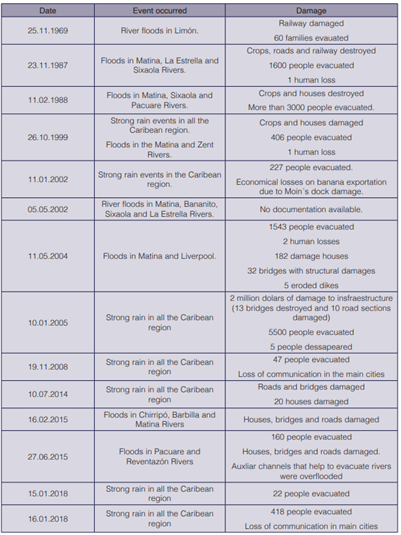
The Caribbean region has a large fluvial network. In most of the region the elevation is less than 300 m.a.s.l and the annual precipitation can reach up to 5 500 mm (3). In this region, the banana plantation occupies 85% of the cultivated area, and out of this percentage, only in the Matina River floodplain the banana plantation occupies 28% of the surface. The increasing frequency of extreme events has generated more frequent floods in the Matina River, affecting urban settlements and agricultural development (table1). The accelerated landuse changes in the upper part of the watershed and the occupation of the floodplains has decrerased the hydraulic capacity of the Matina River (4).
To cope with recurrent flooding in the Matina River it is necessary to use hydraulic modeling tools able to predict the dynamics of floods wich outputs could be used as a tool for decision making in the presence of large-scale precipitation events. Although government institutions, in charge of the water resources management, carry out their own hydrological and hydraulic studies, there is no scientific documentation available to evidence the use of hydraulic models for flood management and decision making, especially in the Caribbean region. Few studies published on hydraulic modeling of rivers in Costa Rica, usually in one dimension, are found in literature (5)-(7). Most of the flood emergency actions have been reactive and the main preventive actions have focused on the dredging of riverbeds and maintenance of dams. Studies have demonstrated that flood mitigation by dams constitutes a high risk, especially when dams exceed 30 m in height (8). Studies such as those of Bocchiola and Rosso (9) and Zhou et al. (10) have shown that one of the main causes of the rupture of dams is due to water levels above the levee level, producing consequently erosion on the slopes.
Authors such as Wang et al. (11) have mentioned that dam failure can be prevented by means of early observation of ridge settlements, turbidity of the infiltrated water table and the spontaneous electric potential, which have showed a high correlation with the dam failure. Jiang et al. (12) demonstrated that the causes of dam failure are mainly due to the permeability and slope at which the dike has been built. Instead, other authors promote flood mitigation options using reservoirs or damping wetlands (13), (14). However, these initiatives require extensive and available areas for water storage, which may become an occupation conflict with human and economical development. Other authors promote non-structural flood management alternativies under the concept of flood resilience, encouraging social policies for mitigation and preparation against extreme events (15), (16).
This study pretends to evaluate two possible flood management scenarios for the floodplain of the Matina River, in the Caribean region in Costa Rica, which local authorities have considered as possible initiatives to reduce the negative impact of extreme events with a 25-year return period. The assessed scenarios were: 1) the elevation of the levees in the floodplain of the Matina River, and 2) the early opening of an auxiliary mouth to alleviate the water level in the floodplain.
Metodology
Study area
The Matina River starts at the confluence of the Chirripo River and the Barbilla River and ends at the mouth of the Caribbean Sea. However, the entire basin covers the complex of Chirripo - Matina Rivers and is located in the province of Limón, belonging to the Atlantic Region of Costa Rica (figure 1). Its drainage area is approximately 1 619.40 km2 which corresponds to 3.17% of the national surface and is between the flat coordinates of 163 000 - 238 400 latitude North and 576 500 - 633 700 West longitude. It presents a rainy season throughout most of the year, with short periods without precipitation in the months of March and September.
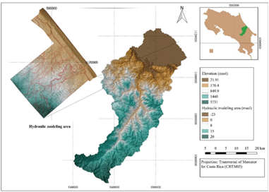
Eleven kilometers upstream of the bridge on Route 32, it begins a transition path, characterized by having a braided riverbed, a pattern that immediately ends downstream of the bridge. This riverbed of the Matina River starts at the confluence of the Chirripo and Barbilla Rivers, which is located 2.8 km downstream from the bridge of Route 32. For hydraulic modeling, 9 km of the Chirripo River were captured with a slope of 0.19% and 8 km of the Barbilla River with riverbed slope of 0.05%. From the confluence of both rivers, the Matina River is directed towards the mouth with a slope of 0.03% and a lenght of 27 km (figure 2). The riverbed of the Matina River presents a network of dikes on both margins, which form a funnel, up to 3 km before reaching the river mouth.
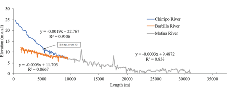
Figure 2 Longitudinal profiles of the bottom of the riverbeds of Chirripo, Barbilla and Matina Rivers.
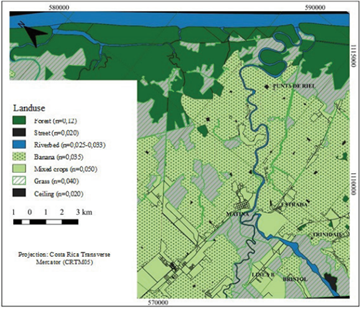
The hydraulic modeling was performed in an area of 273.8 km², covering 38.4% of banana plantation, 29.0% of pastures and other crops, 22.3% of forest cover, 9.2% of riverbed and 1.1% of built areas (ceilings and streets). An open source geographic information system software (17) was used to classify the landuse by means of a supervised classification based on an RGB image (model of red, green, blue) with a resolution of 1.0 m. The landuse layout, was the basis for the selection and assignment of roughness coefficients in the model (Figure 3).
Flow rates
The flow analysis was performed with hydrometric data for a 16-year period (figure 4), from this data record, hydrographs of 26 flood events were constructed with which the relationship between peak flow and total volume generated was analyzed, finding a directly proportional relationship between the two variables, therefore, for the recurrence analysis, it is indifferent which of the two is used (figure 5) .
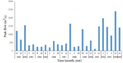
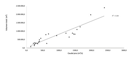
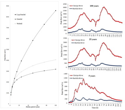
Figure 6 Determination of peak flow () by means of three statistical methods: Log-Gumbel, Gumbel y Weibull.
Making a combination of the peak flows for different return periods and the observed events, hydrograms were constructed for each recorded event, so that, the selection of the hydrogram to be used responds to the similarity criterion between the peak flow rate of the observed hydrogram and the peak flow calculated for each return period.
Hydraulic Modeling
The IBER 2.4.3 (18) hydraulic modeling platform uses mathematical flow modeling to simulate the hydraulic behavior of natural and non-natural currents allowing extraction of two-dimensional information of various variables (draught, velocities, flow, etc.) from numerical methods (finite volume) to solve equations obtained with a series of hypotheses.
Topography data
The digital elevation model (DEM) was obtained from a cloud of terrain points taken with a laser scanner LIDAR (Laser Imaging Detection and Ranging), linked to the bathymetry of the main currents.The hydraulic analysis area is an alluvial plain, with topography ranging from 0 to 22.6 m.a.s.l and groundwater levels between 0.5 - 1.5 m, where flood events occur yearly.
Model Hydraulics Data
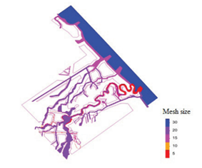
The geometry of the model was built considering the width of the riverbed topography, areas of cultivation and vulnerability of the population. An unstructured mesh was used to facilitate the modelling for irregular areas. Four types of meshing sizes were used: 5-10 m for dikes, 15-20 m for drainage channels, 20 m for riverbed and 30-50 m for the rest of the area (figure 7). The use of four meshing densities obeys the optimization criterion of the calculation process, which takes an average of 8 processing days. The smallest mesh size is assigned for works such as dikes and smaller channels and larger for plains and areas where there are no works relevant to the flow dynamics.
The border conditions of the model were established based on two main input discharges corresponding to the Chirripo and Matina Rivers, respectively. A time of 100 000 seconds was set to fill the riverbed with a constant flow rate prior to the flood hydrograph that ended at 350 000 seconds. The recession curve was extrapolated to 502 000 seconds to observe the transit of the event and to determine waterlogging times in some of the affected villages.
The outputs of the model were established by assigning an average tidal level of 0.07 m.a.s.l based on the reports of the National Meteorological Institute of Costa Rica (19). This level was set as the model exit to the sea, for the north channel of the mouth of the Pacuare River and for the south channel of the mouth of the Matina River
Two scenarios were analyzed separately and independently: 1) the minimum height of levees required to avoid overflow, and 2) the early opening of a river mouth to alleviate the flood for a return period of 25 years.
Option 1. Analysis of the minimum height of levees required to avoid overflow.
The calibrated hydraulic model was restricted to the flow of the riverbed within the area contained by the dikes at both river margins. This allowed defining the minimum crest height That would prevent overflow for an event with a return period of 25 years. Six cross sections located between the bridge on Route 32 and up to 18 km downstream the bridge were analyzed (figure 8). The minimum crest height was used to calculate the volume of material to be removed and the new area required by the dike expansion.
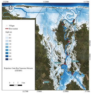
Figure 8 Location of the cross sections for the study of the optimal height of the dikes to avoid overflow.
The map corresponds to the flooded spot produced by a 25-year return period event, which was selected from several return periods due to two reasons: 1) Represents the smallest flood caused by the opening of the alternate mouth, on which modifications are proposed that will be explained in the following section, 2) is the return period that Costa Rican legislation cites for the analysis of protection works in natural channels.
Option 2. Analysis of opening an alternate river mouth to decrease the effect of the flood.
Although the Matina River has its main mouth, the Tortuguero Channel, which is a stream parallel to the beach line, generates a hydraulic connection with other outlets. In addition, for extraordinary flood events, the rivers Barbilla, Chirripo, and Matina overflow, producing large flood spots that exert influence over the nearest mouth.
The analysis considered 1) four rivers mouths (Pacuare River, South Channel, main Matina mouth and Urpiano Lagoon) on which the analyzed flood corresponding to a return period of 25 years had an influence on the flood relief at the outlets, and 2) the flow coming out of the system on the south side of the Tortuguero Channel (figure 12).
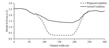
The opening of the alternate Matina River mouth to be analyzed (figure 9) is not active under normal conditions because it has a sand barrier that prevents unloading into the sea. During extreme events, it shows an opening delay (compared to the other mouths) until the water level is sufficiently high to activate it. Therefore, two scenarios were generated, the first scenario was modeled considering normal water level conditions and a second scenario modeled the flow behaviour by modifying the topography of the river mouth to facilitate the water flow at an earlier time step. This modification consisted of giving continuity to the riverbed with a width of 100 m and decreasing the level of the mouth basement up to 0.3 m.a.s.l, parameter obtained from the analysis of the topography of the other mouths (figure 9).
The spatial and temporal flooded areas, the output hydrographs, the total flood area, the magnitude of the depths and the waterlogging time of urban settlements were compared under both scenarios.
Results and discussion
Option 1. Optimal levee height to avoid overflow.
None of the six sections chosen in figure 6 had the capacity to constrain the water flow in the main channel. Figure 10 shows the water level, in each cross-section studied, with respect to the current dike level near to each section. In average, the crest height of the dike was exceeded by 2.2 m by the maximum water level reached in the 25-year event. The course of the riverbed analyzed had a length of 18 km, corresponding to 36 km of dike infraestructure, with an average height of 4.8 m, a dike slope 2:1 (H:V) and a crest width of 5.0 m. The redesign of the dikes to increase their height (maintaining the conditions of the slope), and to avoid overflow, increased the transverse area of the dike in 63 m², being approximately 90% of the actual network of dikes, and requiring in total 2.27 Mm³ of construction material, (figure 11).
The increase of the dike height requires to eliminate 72 hectares of arable area. Implementing this solution could cause a conflict with the development of agricultural activities and urban settlement already existing in the floodplain.
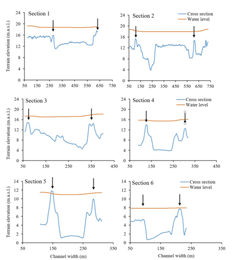
Figure 10 Transverse sections, identified in figure 6, and tightening of a flood with a return period of 25 years. Arrows specify dike location and height.
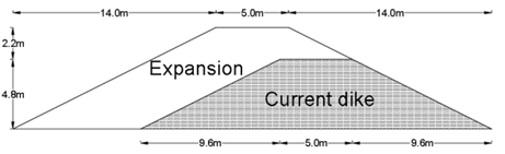
Figure 11 Cross section scheme of the redesign proposals for the dike to avoid overflow with a 25-year return period.
The option of raising the height of the dike is not only economically but socially unviable, because it would require to take up surface area previously occupied by the banana plantation that belong to private entrepenurs. Contrarily, current trends are focused on managing the floods from the perspective of prevention and resilience. Although a height of 7 m dike is considered low, events with longer return periods could generate a high risk of affecting human lives, infrastructure and crops by overflowing water in the crest (10) physical flume tests on the breaching of landslide dams were conducted. A wide grain size distribution with unconsolidated dam material was used. Dam breaching was initiated by cutting a notch across the crest of the dam adjacent to the side wall of the flume. This allowed water to escape from the dam while a steady inflow of water was continuously supplied upstream. The effects of upstream inflow on the timescales and magnitudes of the peak discharges and the time to inflection point were also investigated. Experimental results reveal that the whole hydrodynamic process of dam breaching can be divided into three stages defined by clear inflection points and peak discharge. A new longitudinal evolution model is proposed. This model captures the initial increase of the soil erosion rate (of landslide dam. Some authors have evaluated alternatives for flood mitigation in urban areas. As a structural mitigation strategy Arlikatti et al. (15) and Liao et al. (20) have reported successful cases by building strong stilt houses made of wood, concrete, granite or even metal able to protect human life and tangibles. Kuntiyawichai et al. (21) reported better results for flood mitigation using natural flood storage and the creation of green river than the dike construction, since the later may increase and enhance the risk of an overbank flooding disaster. However, options such as the construction of reservoirs for flood mitigation are not feasible in the area of study because the upper part of the basin (upstream where the rivers Chirripo and Barbilla join) is a natural protected area, and the region below the confluence of both rivers, is occupied mainly by private banana plantations, reaching about 38% of the occupied floodplain along the Matina River. Non-structural mitigation strategies such as raising self awareness and creation of emergency plans have been useful as mitigation strategies (15) and may be an option for population preparness.
Option 2. Opening of an alternate Matina River mouth
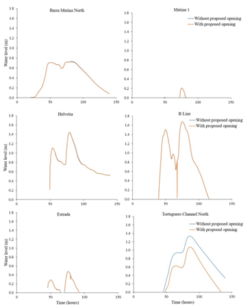
Figure 12 shows, at the top, the location of the existing mouths (Pacuare, South Channel, Matina River, and Urpiano Lagoon), and includes the activation of the alternate mouth (called: Unnamed). In addition, it is observed the placement of six control water level points, in the flood plain of the Matina River (Tortuguero Channel North, Barra Matina North, Helvetia, Estrada, Matina, and B Line).
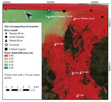
Figure 12 Difference of the maximum levels reached when opening an alternate mouth for an event with a return period of 25 years.
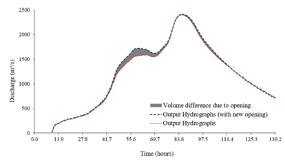
Figure 13, shows the comparison of the output hydrographs without the opening of the alternate river mouth (figure 13a) and including it (figure 13b). By comparing the solid line in figures 13a and 13b, it is observed that there are no significant differences in the total discharge (including all the active river mouths) by the early opening of the additional mouth. The main difference (solid line) between the output hydrographs with the alternate mouth and without it, was observed during the first discharge peak, this represents an increase of the volume discharged of 17 Mm3 wich meant 3% the flood event (figure 14). The early activation of the alternated mouth produced an increased peak discharge at this mouth from 76.8 m³/s to 331.0 m³/s. Additionally, the initial flow loading time moved 33 hours earlier (the activation of the mouth was forward) and the total discharge time went from 56.7 hours to 114.7 hours. However, this modification also generated changes in the hydrographs of the mouths of the Pacuare River and Urpiano Lagoon, as both showed a relief when the opening of the alternate mouth activated.
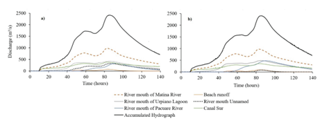
Figure 13 Comparison of the effects of the proposed scenario on the hydrological outputs of the system a) Stage without opening of the River Mouth Unnamed; b) Stage with opening of the River Mouth Unnamed.
The opening of the alternate mouth did not have a significant impact on the water level relief in the flood plain of the Matina River (figure 15), since it only distributed the output load and generated only a localized effect. Figure 15 shows the hydrographs of each control water level point in the floodplain. It is observed that only the control point called Tortuguero Channel North showed an average difference of 30 cm in the water level with respect to the scenario without alternate mouth.
Conclusions
The study demonstrated the importance of information obtained from two-dimensional hydraulic modeling as a tool for decision making. It proved that it is not feasible to resize 36 km of dike at the Matina River floodplain, due to the area required for reconstruction, and the risk for human lives, infrastructure, and crops. The option of activating an alternate mouth to alleviate the discharge produced a localized effect and did not reduce the depth of flooding in the area of interest. The authors recommend decision makers to explore alternatives for flood management focused on population resilience and economic activity.

