


 Inglés (pdf)
 Articulo en XML
 Referencias del artículo
 Enviar articulo por email
 Citado por SciELO
  Similares en
SciELO
Similares en
SciELO 
 Permalink
Introducción
At the global level, Eucalyptus grandis plantations for commercial purposes are an alternative for economic, social and ecological production, since it has a high demand as a forest raw material (1). The tropical regions of Mexico are considered with great potential for the establishment of fast growing commercial forest plantations (PFC), one of them is the genus Eucalyptus grandis with a growth rate, therefore, they are an alternative for reforestation in the southeast of Mexico (2). Eucalyptus grandis plantations are not only important because of their high economic value, but also because they are home to a great biodiversity of wildlife, such as Alouatta pigra in southeastern Mexico (3), Scolopendra cingulata in northern Spain (4), birds, insects (Nephila pilipes); Sylvilagus brasiliensis, Mazama temama, Puma concolor, Canis lupus, Oryzomys nigripes, Monodelphis americana and Marmosa murina in southeastern Brazil (5) (6). These plantations are capable of storing a large amount of CO2 , both in the vegetation and in the soil, they are relevant in the exchange of CO2 between the biosphere and the atmosphere; Therefore, they are considered capable of reducing the concentration of Greenhouse Gases (GHG), as well as great potential to increase CO2 uptake (7). For this reason, it is important to measure certain parameters related to growth, productivity and nutrient cycle in these plantations (8). It is estimated that in southeastern Mexico the reforestation of grasslands with high-productivity Eucalyptus grandis generates a net catch of between 320 and 610 ton/ha in a period of seven years. If it is captured in a reforestation project of 21,000 ha, it is equivalent to 6 to 11% of the annual net emissions of, caused by deforestation in the southeast of Mexico, which is equivalent to 67 million tons per year, which concludes that the project after two years will show significant levels in biomass production and carbon sequestration (9). In addition, these plantations fulfill the function of regulating the hydrological cycle, through water favoring its infiltration and the maintenance of a higher relative humidity than in the uncovered lands (10). Therefore, the Eucalyptus grandis is an ideal species to repopulate deforested and degraded lands or to be incorporated into agricultural lands (5).
The leaf area index (LAI) is an important biophysical indicator of forest health that is linearly related to productivity, and serves as a key criterion for potential nutrient management (11). LAI is widely used in silvicultural decision support, used to monitor, model and manage plantations (12). Modern forestry requires estimating the LAI derived from satellite images. Therefore, there is great potential and an existing need for LAI estimates from medium resolution sensors for use in forest management. There are methodologies that apply equations and where it is important to have data available such as the LAI, for example, to estimate the potential yield of crops, where the method of Agro-ecological Zones (ZAE) proposed by FAO is used (13), and which requires having LAI data. The LAI is a useful variable to characterize the dynamics and productivity of forest ecosystems (14), it provides us with information about the photosynthetic quantity present in relation to the total surface of the ecosystem or study area (15). The direct or field methodologies that are normally used are carried out through the collection of individual plants and the development of complex allometric equations (16), as is the case of the measurement of the LAI in crops of corn in Acayucan, Veracruz, the work was carried out for three years with weekly measurements (17). There are studies where the LAI has been calculated in Eucalyptus grandis plantations through procedures applied in the field, obtaining values with an average (M) of LAI 3.3 in Eucalyptus grandis plantations in Colombia (18), In Costa Rica, they obtained LAI data of 2.5 by indirect method with FDH-app (39). Because of this, there is a need to obtain reliable and accessible data, which is why satellite images such as Sentinel 2 have recently been used to obtain this type of information (11).
Satellite imagery gives forest scientists and managers the ability to obtain accurate and timely LAI estimates (12). Technological advances in geospatial analysis and the launching of satellites capable of retrieving data at more precise resolutions with better focused wavelength spectra and shorter return intervals have provided the opportunity to improve LAI mapping and monitoring at forest sites (11). Operated by the European Space Agency (ESA), Sentinel-2 specifically refers to two satellites, Sentinel-2A and Sentinel-2B, which have been operationally in orbit since the launch of Sentinel-2B in early 2017. In passive remote sensing, The LAI is commonly calculated based on a spectral vegetation index (SVI), which is a combination of multiple spectral bands to calculate a single value. Therefore, the objective of this research is to estimate the LAI from Sentinel 2 images in Eucalyptus grandis plantations.
Materials and methods
Study site
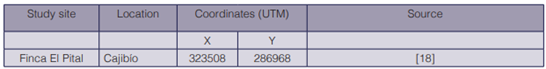
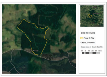
The research was carried out at Finca El Pital. Located in the municipality of Cajibío, Cauca, Colombia (table 1; figure 1).
Acquisition and pre-processing of satellite images
Sentinel satellite images were used, which were obtained from the portal: https://scihub. copernicus.eu/dhus/#/home. With acquisition date of February 11, 2020. Radiometric and atmospheric corrections were made with the QGIS software using the Semi-Automatic Classification plugin.
Model to calculate the Leaf Area Index and sampling
To estimate the Leaf Area Index in Eucalyptus grandis plantations, the model obtained by (11).
LAI = 0.310SR - 0.098
Where SR is the simple ratio of the near infrared (NIR) and red bands (Band 8 and Band 4, respectively) calculated using Sentinel-2 Level-2A surface reflectance images.
The sampling units will be obtained from the study site for their respective statistical analysis.
Data analysis for independent means comparison
Parametric statistical tests were carried out to establish significant differences between the values of each index in the Eucalyptus grandis plantations. Student’s t test was applied for two independent samples, with SAS software.
In this case, two hypotheses were raised:
Results
Estimation of the Leaf Area Index and Sampling
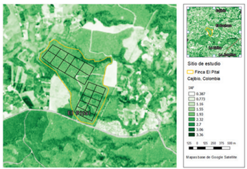
The leaf area index was estimated in Eucalyptus grandis plantations by processing Sentinel 2A satellite images. The study site was divided into 2 sampling units, where in each of them 10 samples were obtained to perform the comparison of means (figure 2).
Statistical analysis of the values obtained from the leaf area index
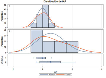
The value of t was -1.76, obtained from the comparison of means of the leaf area index in the two sampling units, and taking with reference the values of TT = ± 2.2622, they show that there is no statistically significant difference, so that statistically the values of the leaf area index are equal, a mean of 2.0 was obtained (figure 3).
Discussion
Anthropogenic activities have deforested forests, establishing Eucalyptus grandis plantations due to their economic value and high growth rate (19). Forests are the main regulators of carbon, energy and water cycles, as they provide the basis for carbon storage, cooling of the earth’s surface and the distribution of water resources (20), as well as biodiversity, so there is no other ecosystem that can replace the functions. However, Eucalyptus grandis plantations have the potential to preserve certain species that are adapted to these plantations, as well as capture carbon by having an active role in the exchange of CO2 between the biosphere and atmosphere (7). But they also generate negative environmental impacts from the preparation of the soil, cleaning with a tractor that can pulverize the soil and when it is carried out with herbicides it causes contamination to the aquifers and water bodies. In addition, herbicides negatively affect native or exotic species of flora and fauna (21). In Eucalyptus grandis plantations, the use of fire as a tool for cleaning the land and controlling undesirable weeds is common, as well as to facilitate exploitation tasks (22). With burning, the soil becomes acidic, organic matter, humus, exchangeable bases are lost and the nutrient content is modified (23) (24). Therefore, the rotational management of plantations with fire has negative effects on soil quality and can be grouped into: abiotic environment (reduction of the amount of water available in the subsoil and loss of soil nutrients) and biotic (inhibition of growth of native vegetation and reduction of local fauna) (21). Eucalyptus grandis and Pinus radiata are plantations with productive purposes, together they represent 70% of the planted area worldwide due to the similar characteristics that they share make them economically very interesting (25). Among them, rapid growth, high productivity, and adaptability to a diversity of environments (26). Eucalyptus grandis plantations have been compared to pine plantations, since both species have significant economic value due to the fact that they are used for various types of human activities (27). The use of pines implies the extraction of wood, production of charcoal and firewood, paper production and various personal handling utensils derived from wood (28), instead the use of Eucalyptus grandis apart from covering the timber productions its nectar is a source of excellent quality honey. The leaves contain 0.12-0.26% essential oil; the main components are d-alpha-pinene, esters and alcohols (29). In general, the Eucalyptus grandis have cups that constitute a rough aerodynamic surface, often with a relatively large leaf surface, which facilitates the exchange of heat and water vapor with the atmosphere. Furthermore, it confers high stomatal resistance, which confers low perspiration (31). The Eucalyptus grandis grandis as they belong to the tropics and can favor the native flora and fauna of the place, while the pines are from temperate zones where you can find greater abundance and richness of small mammal species, such as, for example: Ochrotomys nuttalli, Blarina carolinensis, Peromyscus Spp, which have the highest occupation within the plantations with 88% in habitat (30).
Research has been done on Pine plantations, such as calculating the LAI through satellite imagery in Sentinel 2 (11), it has also been shown to be an important predictor of site nutrient status in pine and can be used to determine the probability of response from forest management (32). Sentinel provides the ability to obtain accurate and timely LAI estimates, thus there is also a strong potential and the existing need for LAI estimates from medium resolution sensors for use in management (11). Due to the relevance of this type of research, the present research carried out the estimation of the LAI in Eucalyptus grandis plantations since this plantation has sufficient similarities to pine plantations in terms of its rapid growth and high productivity, but also being the plantations that generate better wood for the industry. There are other indices that could be calculated through satellite images such as the Normalized Difference Vegetation Index (NDVI) or Soil Adjusted Vegetation Index (SAVI), among others; However, in this research, the Foliar Area Index (LAI) was chosen because it is a metric that currently requires many investigations to calculate this parameter and help to zoning or calculate the potential yield of certain crops (13). Similarly, the LAI provides information about the amount of photosynthetic surface that exists in relation to the total surface of the ecosystem and is related to vital processes such as photosynthesis, respiration, and productivity, therefore, it is important to have spatial information. LAI at landscape scale (15) (33). The most widely used indirect method for estimating the LAI is based on satellite images and consists of associating it with spectral characteristics and vegetation indices. Consequently, accurate maps with the spatial distribution of the LAI are necessary for a better understanding of the structure and function of forests and to quantify different biophysical and / or biological variables in them (15). Over the years it has been shown that the use of satellite images for monitoring and estimating the LAI of tree species is a viable option, because notable setbacks are avoided such as travel to the sampling site, exposure to the climate per season in the area, the use of expensive and delicate devices, among others (11) (17) (14).
Satellite images with high spatial resolution potentially provide more texture information than medium resolution data because they allow the finest structure of the forest to be distinguished, for example vegetation structure, canopy structure, tree height and the spacing between them. This fine structure is manifested in images with high spatial resolution as variations in the tonality of the image (34). The texture information extracted from satellite images has been shown to improve the precision of LAI estimates (35) (34), given that the information on the texture of pixels and the high spatial resolution of the image are associated with the structural attributes of the forest (36). However, remote sensors that have high spatial resolution to estimate the LAI at a local scale lack the temporal resolution to map the evolution of the vegetation in different stations. Texture information extracted from high-resolution images together with spectral information from the image better characterizes the LAI. The results of the study is that the LAI varies not only to the phenology of the forest, but also due to the relationship between field measurements and estimates based on satellite images that change between stations, generating models with different explanatory variables (15). In the present study, through satellite images, the leaf area index was obtained remotely with an average of 2.0, this data is similar to those obtained in field investigations where average values of 2.1 have been obtained (18), and using a pair of LAI2000 equipment, resulting in the LAI an average of 2.86 (37), and 2.75 (38).
Conclusions
When comparing studies carried out in the field, in this research good estimates of the LAI were obtained in Eucalyptus grandis plantations through the use of satellite images such as Sentinel, so it is recommended to use this methodology in other forest plantations such as Pinus radiata, as that these plantations are very similar to those of Eucalyptus grandis. Reliable data were obtained from the LAI to be applied in other methodologies used to estimate the potential yield of certain crops, so it is also recommended to calculate other indices such as the NDVI or SAVI in these plantations that could be used to measure the health of the plantations. These tools serve as silvicultural decision support, used to monitor, model, and manage plantations.

