


 Inglés (pdf)
 Articulo en XML
 Referencias del artículo
 Enviar articulo por email
 Citado por SciELO
  Similares en
SciELO
Similares en
SciELO 
 Permalink
Introduction
Human and economic losses from structural and non-structural damage are major consequences of earthquakes. The development and implementation of seismic building codes during the last decades have reduced building collapse, thus securing human lives (Moammer et al., 2020). The Central America region is known for their high seismic hazard values (Shi & Kasperson, 2015). Recent consensus has been made defining different seismic zonation units along Central America (Alvarado et al., 2017). Moreover, the region includes many countries with high global seismic risk (Shi et al., 2016). This si- tuation is even more relevant in emerging countries and smaller economies such as Central American countries that frequently face challenging economic situations after a disaster (Noy, 2009; Klomp & Valckx, 2014).
Due to the available information before 1991, the Earth Sciences specialists considered the Caribbean region of Costa Rica and Panama as a low seismic potential area. The historical and instrumental analysis had shown important seismic events during the 19th and 20th centuries in this territory, particularly the San Estanislao earthquake that occurred on May 7, 1822, which presented a reverse fault with epicenter and characteristics similar to the 1991 event (Boschini & Montero, 1994). Moreover, another big event recorded in Bocas del Toro on April 26th 1916 with a projected magnitude of 7.0 Mw. The Limón earthquake occurred on April 22, 1991 at 9:56 p.m. (UTC). This event impacted an area of approximately 8000 km2, an 80% of this area in Costa Rica and 20% in Panama. The greatest damage was to vital lines: roads, railways, bridges, ports and aqueducts. 7439 people throughout the impacted area were victims of this event, as well as 49 casualties in Costa Rica and 79 in Panama. The maximum intensity determined was X on the modified Mercalli scale and the estimated econo- mic losses were approximately $188.3 million, equivalent to 4.21% of the Costa Rica Gross Domestic Product of this year (Obaldía et al., 1991; Morales, 1994). During the emergency response phase, humanitarian assistance was a priority followed by the rehabilitation of infrastructure. An airlift and a communications network, as well as healthcare facilities, shelters, and emergency supplies were rushed to the area (Morales, 1994). Limón earthquake showed how vulnerable were Costa Rica and Panama facing intense disasters.
The increasing conditions of vulnerability in Costa Rica and Panama due to the inefficient territorial management leads to the occurrence of cascading disasters (Quesada-Román, 2015; Quesada-Román et al., 2020). Moreover, the impact of an ex- treme natural hazard produces a sequence of events in human subsystems that result in physical, social or economic interferen- ce (Alexander, 2018). Furthermore, the number of investigations on vulnerability and risk in these countries should increase and must be accompanied by government actions in order to reduce disasters (Quesada-Román et al., 2018; Quesada-Román & Villalobos-Chacón, 2020). Reference disaster information and natural hazards cartography for Costa Rica and Panama must be enhanced (Quesada-Román, 2017; García-Soriano et al., 2020). The development of earthquake warning systems could significantly diminish the associated risks (Allen & Melgar, 2019).
This study identified that geomorphic responses to the 1991 Limón earthquake have been studied separately (e.g. lands- lides, coastal uplift, liquefaction, extreme subsequent sediment yield rates), thus limiting their holistic implications in geody- namics and the disaster risk understanding. Hence, an integrated review of the geomorphological effects of the 1991 Limón earthquake is key to understand the hazardous dynamics of extraordinary seismic events in tropical contexts and reduce its disaster risk.
Study area
The effects of the Limón earthquake were directly related to the structure of the backarc (Marshall, 2007; Fig. 1), which represents the Caribbean lowlands of Costa Rica and has a SE continuity towards Panama. The Limón Basin, which is in the backarc, suffered the greatest direct and indirect effects from the Limón earthquake. The northern limit of the Limón Norte Basin is defined by a series of positive buried structures, aligned in an EW direction and of Middle Late Eocene age. The re- gional uplift of the southern coastal region of the Caribbean reveals that the structural-tectonic styles are different (Fernández et al., 1994). The area between Limón Norte and the Limón Sur basins is an extension of the Central Costa Rica Deformed Belt and remains tectonically active (Fernández et al., 1994; Marshall et al., 2000).
The Limón Basin consists of sediments resulting from the erosion of the Talamanca and the Central Volcanic Cordilleras. The product of this shallow deposition and turbidity environments deposited over 65 million years is a lithological sequence of Cenozoic sedimentary and volcanic rocks. These lithologies are tectonically controlled by folds with EW and NW-SE axes and faults with NS, EW and NW-SE strikes. Among the formations of the Limón basin are the Tuis, Fila de Cal, Pelada, Barbilla, Senosri, Uscari, Río Banano, Quebrada Chocolate, Moín and Suretka formations (Aguilar, 1999; Alvarado, 2007; Bottazzi et al., 1994; Denyer & Fernández, 1994; Fernández et al., 1994; Linkimer & Aguilar, 2000). The geomorphology of this region consists of alluvial fans (Galve et al., 2016), extensive alluvial plains of the Chirripó, Tortuguero, Reventazón, Pacuare, Matina, Madre de Dios, Moín, Banano, Bananito, La Estrella and Sixaola rivers in Costa Rica (Quesada-Román & Pérez-Umaña, 2020), as well as the Changuinola river in Panama. All these rivers originate in the Central Volcanic and in the Talamanca cordilleras draining to the Caribbean Sea. Geomorphological features include the Tortuguero lowlands, the Limón headland, carbonate platforms from Cahuita to Manzanillo, and the Bocas del Toro archipelago.
The Limón earthquake had its epicenter in the Limón - Pandora area at the geographical coordinates 9.685° N and -83.073° W (Fig. 1). The primary rupture had four sub-events in a 25-second period and a rupture area of 3200 to 4500 km2. The size of the rupture zone, the complexity of the main event, and the number of aftershocks indicate that secondary faults structures could be associated with the main rupture plane (Montero et al., 1991; Güendel et al., 1991; Rojas, 1991; Goes & Schwartz, 1991). Geodetic and seismologic data indicate that the main rupture dips landward at an angle of about 30° and is approximately 40 km wide and 80 km long. Dislocation models suggest 2.2 m of slip on a causative thrust fault that strikes between 105° and 120° (Plafker & Ward, 1992). The interpretation of the focal mechanism, the rising of the coastline and the horizontal movement towards the NE in the surroundings of Limón suggest that the main fault plane projects into the sea (Denyer et al., 1994a).
Materials and methods
Data sources
The first phase consisted of an exhaustive bibliographic review of national and international scientific articles. This research also includes reports from the National Commission for Risk Prevention and Emergency Care (CNE), the National Seismological Network (RSN-UCR) and the Earthquake Engineering Laboratory of the University of Costa Rica, the Seismological and Volcanological Observatory (OVSICORI) of the National University of Costa Rica, and other independent studies related to the event. In the second phase, the data organization allowed the generation of a series of bibliographic records where the most relevant data from each book, scientific article, reports, or maps used in the analysis were identified.
Geomorphological effects, remapping and analysis
The geomorphological impacts remapping focuses on landslides, liquefaction, and coastal uplift. Moreover, this study reviews and analyzes of other processes such as increased sediment load in the river basins months after the earthquake, a tsunami occurrence, and a probable relationship with recent coastal erosion processes. To depict the landslide areas, this study uses the best resolution maps made after the Limón earthquake by Hernández et al. (1992) and Mora & Mora (1994). Liquefaction and tectonic uplift measurements were based on Denyer et al. (1994aa, b), Camacho & Víquez (1994), as well as Mora & Yasuda (1994). These maps were georeferenced, digitized and edited using ArcMap 10.3. These layers are available under request to the author.
Results and discussion
The 1991 Limón earthquake is an interesting example to illustrate and help understand the geomorphic dynamics and evolution in tropical conditions. The most significant processes resulting from the event were the coastline uplift, liquefaction, landslides, subsequent floods as well as the extraordinary sediments load in the rivers and coasts, a tsunami, and in recent years the coastal erosion processes (Fig. 2).
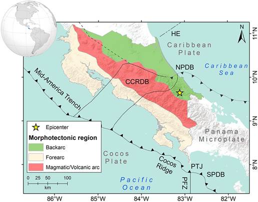
Fig. 1: Morphotectonic framework of Costa Rica (Source: ArcGIS Online Basemap; Projection GCS; Datum WGS84). HE: Hess Escarpment; CCRDB: Central Costa Rica Deformed Belt; NPDB: North Panama Deformed Belt; SPDB: South Panama Depression Belt; PFZ: Panama Fracture Zone; PTJ: Point Triple Junction; Epicenter of 1991 Limón earthquake (DeMets et al., 2010; Morell, 2016; Arroyo-Solórzano et al., 2020).
Landslides
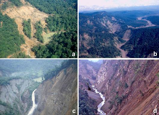
Landslides impacted approximately 2000 km2. The most affected areas were the upper basins of the Estrella, Banano, Bananito and Chirripó rivers (Fig. 3), where massive and extensive landslides occurred (Mora & Mora, 1994). The landslides map by Hernández et al. (1992) also coincides with the broad cartographic analysis by Mora & Mora (1994) and the one focused in Panama by Camacho & Víquez (1994). Hernández et al. (1992) determined a total of 1834 landslides caused by the earthquake, which varied in size depending on their location (lithology, slopes, degree of weathering, and rainfall). The otherwise forested areas of the Talamanca Cordillera exposed by each of the coseismic landslides varied between 3157 m2 and 19.15 km2.
The most affected sites by gravitational processes due to the Limón earthquake are slopes formed by sedimentary and intrusive rocks of the Cenozoic period with various degrees of weathering. The Tuis Formation comprises a large portion of the local bedrock dates back to the Paleocene and much of the Eocene (60 - 37 Ma). The origin of these rocks is related to the existence of a volcanic island arc, which contributed with large amounts of volcanic sediments to the seas. Many of these materials were deposited on the narrow continental shelf that existed in the Paleocene and were later removed as avalanches, which flowed down the continental slope (Bottazzi et al., 1994).
These areas of maximum incidence, geomorphologically coincide with those of high values of the relative relief index (i.e. relief energy) values. Most of the landslides caused the detachment and mobilization of the residual soils and altered rock where thickness did not exceed 10 m (Mora & Mora, 1994). The relationship of the Relative Relief Index with the areas of greatest mass movement activity suggests the possible link with other morphometric variables such as incidence of disjunctive structures (fractures, faults, and tectonic alignments), intense Caribbean rainfall (≥3000 mm annually), and weathering degree of substrates (rock, debris, or soils).
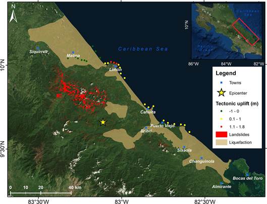
Fig. 2: Geomorphological effects of the 1991 Limón earthquake. Modified from Camacho & Víquez (1994), Denyer et al. (1994a, b), Hernández et al. (1992), Mora & Mora (1994) and Mora & Yasuda (1994).
Other morphometric variables such as the dissection density (i.e. concentration of rivers in a specific area), dissection depth (i.e. relative height between the most representative slope rupture and the thalweg), and total erosion (i.e. density of curves of level in a defined area) have high values in their metrics. According to Mora & Mora (1994) the landslides were classified as surface landslides of the regolithic horizons (69%), detachment and landslides of rock masses (20%), translatio- nal landslides of soil and rock masses (8%), and translational landslides of masses composed predominantly of soils (3%). In Costa Rica, similar recent coseismic landslide processes were reported close to Poás volcano during the 2009 Cinchona ear- thquake (Quesada-Román & Barrantes, 2016, 2017; Ruiz et al., 2019) and Sámara in 2012 (Peraldo et al., 2014). Worldwide landslide mobilization rates are higher in seismic regions with similar topography, lithology, different precipitation intensity and vegetation cover (Broeckx et al., 2020). Therefore, these processes are common and should be monitored (Quesada- Román et al., 2019).
Landslides increased with the above-average high intensity rains of the subsequent months (i.e. from May to August). Consequently, the coupling of earthquake-related slope processes with high precipitation produced large floods and transport of unusual amounts of sediments into the local basins (Amador et al., 1994). Moreover, Amador et al. (1994) found a direct relationship between the most affected basins by coseismic landslides of the Limón earthquake (Bananito and La Estrella) and the postseismic sediment discharge the following months using Landsat and Spot images. These processes caused an accele- rated erosion and the generation of mud and rock avalanches. Moreover, some river channels dammed, subsequently breached resulting in increased flows and flooding which caused additional damage to the population, vital lines and productive activi- ties in the lower regions (Mora & Mora, 1994). Similar processes occurred in the Poás volcano after the Cinchona earthquake in 2009 (Alvarado, 2010), and Miravalles volcano after the Bijagua earthquake and hurricane Otto in 2016 (Quesada-Román et al., 2019). These hazardous processes should be monitored through early warning systems along the catchments to reduce the risk of potential disasters.
Tectonic uplift
One of the most spectacular tectonic effects was the coseismic uplift of approximately 100 km of the Caribbean coastline. The magnitude ranged between 0.3 and 1.85 m in blocks separated by NE trending faults along the calcareous platform. There is also an inland manifestation, with an uplift greater than 3 m (Denyer et al., 1994a, Denyer et al., 1994b). This deformation was discontinuous and ranged from 40-50 cm near La Estrella river, 40 cm at Muelle Alemán, and 2 m at Playa Bonita. The te- rraces of the new coastline had different elevations, from 15 to 20 m in front of the Limón airport, 30 m to the left margin of the Banano river and about 50 m at the mouth of the La Estrella River. The new tide level on rocky beaches changed dramatically with varying results in different locations, including changes that reached more than 60 m at Playa Bonita (Amador et al., 1994). Obaldia et al. (1991) indicate that changes in the coastline were greater in magnitude in Limón and decreased towards the northwest and southeast of the city. A maximum uplift of 1.51 m was found between the Moín pier and Portete beach, and a minimum of 0.36 m was located west of the Limón cemetery. The changes in slope as a result of the coseismic uplift are not uniform (Fig. 2). However, these variations directly affected the drainage regime and infrastructure works for which the level modifications are important. To the northwest of Limón, in the Moín-Doce Millas town, the change in elevation decreases uniformly. In contrast, to the southeast of Limón, the coseismic deformation was positive and decreased in magnitude away from Limón (Denyer et al., 1994a; Fig. 4).
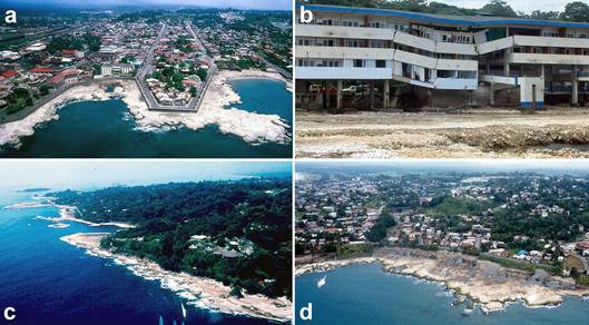
Fig. 4: Coastal uplift in the city of Limón and surroundings (a,c,d); collapse of Las Olas Hotel in Limón City (b). Photos provided by Sergio Mora Castro.
According to the historical analysis, the data suggest that there were two Quaternary events prior to 1991, whose mag- nitudes were greater than 7.0. The pre-1991 uplifts were basically vertical with slight deformation or tilting as indicated by the horizontal terraces at about 50 m of elevation in the city of Limón (Denyer et al., 1994a). A resulting parallel effect to the coastline uplift was the impact on organisms in the intertidal zone. Along the shallow sublittoral and coral reefs, these ecosystems were exposed and died soon after. In the Cahuita National Park, broken corals, cracks in the reef structure and collapse of the reef front were observed (Cortés et al., 1994). The superposition of raised carbonate platforms indicates that these processes have been taking place for a long time (Cortés & Jiménez, 2003). The cities of Limón, Cahuita and Puerto Viejo were built on uplifted fossil reefs (Quesada-Román & Pérez-Briceño, 2019).
There were reports of a tsunami occurring along the southern Caribbean of Costa Rica and Bocas del Toro in Panama where the effects were higher (Camacho, 1994). Presumably, the uplift of the coral reefs reduced the tsunami effects in the coast of Manzanillo, Punta Uva and Limón (Denyer et al., 1994b).
Liquefaction
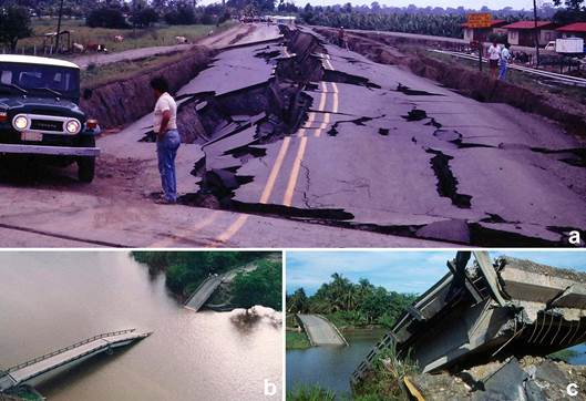
Approximately 3000 km2 were affected by soil liquefaction. This event occurred in the lowlands of the eastern sector of the Costa Rican and NW Panamanian Caribbean coast, with special activity in the littoral corridors, sandy bars, and borders of estuaries, channels and coastal lagoons. Deformation on these landforms, including soil fracturing (Mora & Yasuda, 1994) developed more intensely due to the unconsolidated materials. The liquefaction processes caused the collapse of five bridges, most of them small in size but severely damaged and eight railway bridges settled or suffered partial deterioration (Fig. 5). A total of 80 km of pavement and road fill were destroyed, preventing vehicular traffic (Sauter, 1994).
In a future similar seismic event to that of 1991, a similar or greater liquefaction response is to be expected. This eventual event will occur because it was not evident that the design of the new structures (specially reconstructed bridges) would make them capable of withstanding a similar event (Mora & Yasuda, 1994). The areas affected by liquefaction during 1991 relate to central cantonal towns or those with a significant population density such as Bribri, Sixaola, Puerto Viejo and Cahuita in Talamanca, Pandora and Limón in the canton of Limón and the urban center of Matina. These are also areas dedicated to bana- na cultivation, tourism, and important banking, health, and education service centers. A future seismic event without preven- tion measures, would result in significant human and economic loss. Therefore, the application of seismic hazard zonation and assessment, and adequate infrastructure construction and preparation processes for the local populations should be compul- sory with the available new technologies and data of different agencies in Costa Rica and Panama (Cremen & Galasso, 2020).
Coastal erosion
During the last decade, intense coastal erosion was reported on sandy beaches of the southern Caribbean, especially bet- ween the port of Limón and Manzanillo. Barrantes et al. (2020) measured intense erosion rates during the last two decades. Nonetheless, they do not indicate a direct relation with the Limón earthquake, despite the fact that most of the eroded sites are in the most uplifted area (almost 2 m), as previously reported by Denyer et al. (1994a). It is possible that in the years following the Limón earthquake, significant post-seismic relaxation occurred (Quesada-Román, 2016). Moreover, Quesada- Román & Pérez Briceño (2019) mapped these areas as uplifted carbonate platforms during Quaternary tectonism. More pre- cise geomorphological assessments must be performed in the Caribbean coastline of Costa Rica and Panama to unravel the seismic relationships with the present coastal erosion processes. Similar processes have been demonstrated during the Late Pleistocene in Chile (González-Alfaro et al., 2018), throughout the Holocene in Taiwan (Chen et al., 2020), and recently in Sumatra, Indonesia (Monecke et al., 2017).
Conclusions
This study presented a review of the geomorphological effects resulting from the 1991 Limón earthquake on the Caribbean coast of Costa Rica and Panama. Landslides impacted approximately 2000 km2 of the Caribbean slopes of the Talamanca Cordillera. A total of approximately 1834 landslides with areas between 3157 m2 and 19.15 km2, mostly composed of weathe- red Cenozoic sedimentary and intrusive rocks, were affected. The tectonic uplift movement ranged between 0.3 and 1.85 m with the highest levels in the city of Limón. The most devastating effects were the coastline uplift and liquefaction, the latter affected about 3000 km2 in Costa Rica and Panama. This resulted in a significant number of casualties, economic loss, cro- plands affectation, and the collapse of roads and many bridges. A tsunami mainly affected Panama, as coral reefs protected the Costa Rica Caribbean towns. Moreover, landslides and their subsequent debris flows triggered by extreme rainfall months after the earthquake, fed large amounts of sediments into the fluvial systems of Chirripó, Banano, Bananito, and La Estrella rivers. Despite the different studies about landslides and liquefaction due to extraordinary seismic events in the Caribbean coast of Costa Rica and Panama during the last three decades, there are no clear prevention measures, earthquake warning systems and/or better building codes in place to diminish the potential impacts of seismic events in the future. Integrated analysis of the geomorphic coseismic and postseismic effects are useful tools to understand the geodynamics of understudied tropical actively tectonic regions.

