


 Inglês (pdf)
 Artigo em XML
 Referências do artigo
 Enviar este artigo por email
 Citado por SciELO
  Similares em
SciELO
Similares em
SciELO 
 Permalink
Introduction
Since 1530 the Caribbean region has experienced at least 83 tsunamis caused from earthquake, volcano and landslide producing at least 4,500 deaths (NOAA/NCEI, 2020). The most recent devastating tsunami occurred in 1946 in Dominican Republic causing almost 2000 deaths and since then, the coastal population and touristic development in the region has grown exponentially. However, it was until 2005 that it was established the Intergovernmental Coordination Group for Tsunami and Other Coastal Hazards Warning System for the Caribbean and Adjacent Regions (ICG/CARIBE-EWS) of the Intergovernmental Oceanographic Commission (IOC) of UNESCO. Costa Rica has been a member of the ICG/CARIBE-EWS since the beginning, participating in trainings, Caribe Wave exercises and other activities to increase tsunami preparedness at the Caribbean coast.
However, tsunamis are scarce in Costa Rica and before 1991 were not considered a threat. The seismic threat on the Caribbean coast was also underestimated by then, despite there were important earthquakes there in 1746, 1798, 1822, 1904, 1916 and 1953 (Boschini & Montero, 1994; Camacho & Víquez, 1993; González-Víquez, 1910; Montero, 1986, 1989; Peraldo-Huertas & Montero, 1994; Peraldo & Montero, 2007). The 1991 Valle de la Estrella earthquake and tsunami triggered research on historic events allowing to find new information, including the list of events above.
At the 30th anniversary of the 1991 event, the authors present a summary of tsunami history for the Caribbean coast of Costa Rica. This summary includes unpublished information related to 1991 tsunami and to previous events, discovered during the writing of the ''Historical Tsunami Catalog for Costa Rica until 2020'' (Chacón-Barrantes et al., in press).
The Caribbean coast of Costa Rica has experienced two confirmed tsunamis and three probable tsunamis. All the records correspond to local tsunamis. The 1991 tsunami is the one with more records associated in the country and had the highest impact known so far, being the only one causing deaths.
Methods
Records of historical tsunamis can be found on marigrams, interviews with witnesses, scientific papers, books, and newspapers. Limon tide gauge was installed in 1940 using paper rolls to record the sea level. Unfortunately, the paper rolls from 1940 to 1969 were destroyed thus we were not able to search for changes on sea level associated to the 1953 earthquake; and in April 1991 the tide gauge was not working. In 2019 the authors interviewed the medical doctor Mayela Valerio. In 1991 she was one of the physicians issuing death certificates for the victims of the earthquake and the tsunami (Chacón-Barrantes et al., in press).The authors performed an extensive bibliographic review of books on historical seismology (Peraldo-Huertas & Montero, 1994, 1999), papers on scientific journals (Boschini, 1989; Boschini & Montero, 1994; Boschini, Rojas, & Vargas, 2014; Camacho, 1993, 1994; Camacho & Víquez, 1993; Nishenko, Camacho, Astorga, Morales, & Preuss, 2021; Peraldo & Montero, 2007; Suarez et al., 1995) and catalogs of historical tsunamis (Molina, 1997; NOAA/NCEI, 2020). Besides, we searched the online database of newspapers of the National Library (SINABI, 2020) for reports of anomalous changes on sea level that could be associated to tsunamis.
The authors defined the following criteria to classify the tsunami events:
• Confirmed: if there is at least one report of flood or sea retreat unquestionably associated to a seismic event
• Probable: if there is a report of abnormal sea behavior that very likely corresponded to a tsunami (can be associated to an earthquake), but cannot be confirmed, more likely because could have an alternate explanation.
Results and discussion
There are reports of five tsunami events in the Caribbean coast of Costa Rica, with impact ranging from abnormal sea behavior to deaths. Also, there were earthquakes in 1904 and 1953 with no tsunami record associated (Figure 1). From the five tsunami events, the authors found new information related with three of them: 1746, 1916 and 1991. Previously, the 1916 tsunami had reports only at Panamá. The 1746 event had no report of tsunami associated until now. All the tsunami records correspond to locations south of Boca Matina, there are no records for the north Caribbean coast (Figure 1). This might be due to sparse population, lack of preservation of the reports or absence of tsunami impact, which is unlikely.
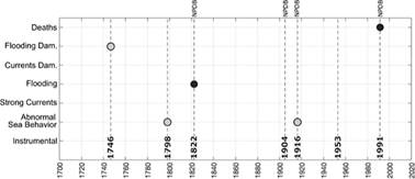
Fig. 1: Dates and impact of tsunamis at the Caribbean coast of Costa Rica. Black circles correspond to confirmed tsunamis, grey circles correspond to probable tsunamis and the white circle correspond to doubtful tsunami. The lines without circles correspond to earthquakes with no tsunami records associated.
It is not possible to establish a recurrence period of tsunamis in the Costa Rican Caribbean coast. There are only two confirmed tsunamis with 169 years of difference. If all the earthquakes are considered, the time lapses are 52, 24, 82, 8, 37 and 38 years. The epicenter of the 1916 event was offshore Panamá (Figure 2), if we consider all the other earthquakes the time lapses are 52, 24, 82, 49 and 38 years, but there is not possible to know if all the mentioned earthquakes had the same origin. Only 1822, 1904, 1916 and 1991 are confirmed to correspond to North Panama Deformed Belt (NPDB) activity (Camacho & Víquez, 1993), having time lapses of 82, 8 and 75 years. Also, there might be other events so far unknown.
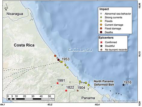
Fig. 2: Epicenters of earthquakes causing confirmed tsunamis (red stars), possible tsunamis (black star) and earthquake with no tsunami associated (brown stars). Also are shown the tsunami records (colored dots) at Costa Rica Caribbean coasts. Basemap: Atlas ITCR (2014), tectonics: Protti et al. (2001), impact and epicenters from Chacón-Barrantes et al. (2021).
In the following sections, the authors describe each tsunami event, giving its classification and including new information when available. Events with no new information are also included for completeness.
21 June 1746 - Probable tsunami
The oldest tsunami record we were able to find corresponded to 1746, when the Interim Commander of San Fernando Fort at the mouth of Matina river reported: ''a hurricane came suddenly from the sea that put us in great horror and confusion seeming to be the last days of life, taking in its first fury the house where the officers live leaving everything destroyed and useless, as well as the gunroom (…) presenting before this destruction an earthquake'' (Peraldo & Montero, 2007, p. 34; translated by the authors).
We think that this event very likely corresponds to a tsunami rather than a hurricane, considering that the earthquake happened right before the ''hurric ane''. Also, the use of the verb ''sobrevenir'' in the original Spanish version, which definition is ''to come suddenly'' (RAE, 2014), indicates a sudden event rather than a sustained one, as it is the case of hurricanes. Furthermore, the phrase ''taking in its first fury the house where the officers live'' suggest the arrival of several waves.
The concept of tsunami did not exist in the residents of Boca Matina at that date, which might explain the confusion. As a reference, to our knowledge only four tsunamis had happened at America before that date: 1530 at Venezuela, 1690 at Antigua, 1692 at Jamaica and 1700 at Cascadia (Pacific U.S.) (NOAA/NCEI, 2020) and the largest tsunami affecting Portugal and Spain happened in 1755, nine years after this one.
Other authors indicate that the Fort of San Fernando, built in 1742, was partially destroyed by the 1746 earthquake (Boschini & Montero, 1994), although the forementioned text makes reference to damages caused by the ''hurricane'' rather than the earthquake. In 1747 the Fort was attacked and burned down by pirates, being totally destroyed (Boschini & Montero, 1994), as the damages caused by the ''hurricane'' were not likely repaired yet.
This earthquake was not mentioned by González-Víquez (1910), who listed earthquakes in 1728 and 1756, and there is only one report at one place and from one source associated to this event. It cannot be assured that the report corresponds to a tsunami, as there are other possible explanations like a storm. Consequently, this event is classified as probable.
22 February 1798 - Probable tsunami
González-Víquez (1910) reproduces the report of earthquakes from the Commander of Matina on 22 February 1798, who also said ''since the earthquakes started, the sea is so restless that it seems is going to come over us'' (p. 16; translated by the authors). This description very likely corresponds to a tsunami but again could have an alternate explanation such as wind waves. Also, there is only one report at one place and from one source and thus we classified this event as probable tsunami.
Although this event is referred to Matina, the correct location of the report is Boca Matina, the mouth of Matina river. This event is included at the Tsunami Catalogue for Central America 1539-1996 (Molina, 1997) and the authors did not find new information related to this event.
7 May 1822 - Confirmed tsunami
González-Víquez (1910) reports from historic papers that ''in (Boca) Matina there were three violent shakes as no resident remember to had felt before; (…) that the rivers and bay grew and caused floods'' (p. 21; translated by the authors). The flooding caused by rivers can be explained by plugging caused by landslides consequence of the earthquake, but the ''grew'' of the bay and its subsequent flooding can only be explained as a tsunami.
The earthquake was also felt in Bocas del Toro (Camacho & Víquez, 1993) and a tsunami was reported in the same region between 1820 and 1830, that might correspond to this one (Boschini & Montero, 1994). As there are two reports of the same event in different places this tsunami is confirmed.
This earthquake was initially located at Osa region by Montero (1986), without discarding its Caribbean origin. The later was confirmed by Boschini and Montero (1994) and Camacho and Víquez (1993) based on macroseismic studies and comparation with the 1991 event, including liquefaction and tsunami reports. This tsunami is also included at the Tsunami Catalogue for Central America 1539-1996 (Molina, 1997) and the authors did not find new information related to this event.
25 April 1916 (26 April 1916 UTC) - Probable report in Costa Rica of a confirmed tsunami in Panamá
After an earthquake on 25 April 1916 ''A small tsunami throw litter and canoes some two hundred meters ashore'' (Camacho & Víquez, 1993, p. 63) in Bocas del Toro, Panamá; other reports indicated that ''sea flowed over knee deep into the land'' (Camacho & Víquez, 1993, p. 61).
In the Costa Rican newspaper ''La Información'' of 29 April there is an interview to Dr. Roberto Jiménez Ortiz, who was at ''the Costa Rican town of Sixaola'' at the time of the earthquake and said: ''right at that moment, the waters of the mighty and wide river that divides both territories, surpassed their banks and loud rumbles were heard also in the depths of the water, those noises produced by something like big subterraneous dislocation or the crash of thousand stones agitated by furious currents'' (''La Catástrofe En Bocas Del Toro, Almirante y Sixaola'', 1916, p. 4).
Currently, Sixaola is located at more than 18 rkm (river-kilometer, distance along a river from its mouth) and more than 11 km from the sea in a straight line. It is a long distance, but it is common to observe tsunami induced changes on rivers at very long distances inland. For example, in 1983 a Mw=7.8 earthquake in Noshiro, Japan was observed up to 15rkm. Also, the 1941 Osa tsunami in the Pacific coast was reported in Puerto Cortés, located at 15rkm.
The earthquake occurred during nighttime, hindering possible further observations of the river, like changes of flow direction and observations in the coast. We consider this report at Sixaola as probable, as it might have an alternate explanation, but the most likely is the tsunami. This is a confirmed tsunami in Panamá.
22 April 1991 - Confirmed tsunami
This event and the Nicaragua Mw 7.6 tsunami-earthquake occurred in September 1992, launched regional earthquake and tsunami research in Central America, resulting in the first tsunami catalogue for the region (Molina, 1997).
There were no seismographers in the region in 1991 (''Terremoto En Limón'', 1991) and the tide gauge in Limón was not working that day. The tsunami was registered at three tide gauges in Coco Solo (Panamá), Magueyes Island (Puerto Rico) and Limetree (US Virgin Islands), with a maximum height of 76 cm in Panamá and 7 cm at the other two locations (NOAA/NCEI, 2020).
Even when the 1991 event was the tsunami with the highest impact in Costa Rica (Chacón-Barrantes et al., 2021), it was unnoticed by the rest of the country. Costa Rican newspapers informed that a tsunami occurred in Panamá. For example, Diario Extra (''Terremoto Dejó Muertos En Panamá'', 1991, p. 9) wrote: ''Bocatoreños (…) were seen moving to highlands to escape the big waves that hit the lower parts of the islands.'' La República (''Terremoto Afectó La Mitad de Centroamérica'', 1991, p. 11A) wrote: ''In the archipelago of Bocas del Toro (...) there was a small surge due to the earthquake''.
La Nación used a full page to report the consequences of the earthquake and tsunami in Panamá. The article ''What a disaster!'' included an aerial photograph of the tsunami damages with the caption ''A strong surge ''washed'' the vicinity of the dock in Puerto Almirante. Desolation and havoc everywhere'' (Martínez, 1991, p. 10). It also said: ''The berth in Almirante is partially damaged and, nearby, bared land with only a few houses standing or damaged by the strong surge that hit the place on Monday afternoon'' (Martínez, 1991, p. 10).
The second article ''Death and damages at Panamanian province'' has more information about the tsunami:
Colón, the main island of the Bocas del Toro Archipelago, was badly affected by the earthquake, which was followed by a small tsunami that destroyed 72 homes, killed one person and injured another, according to reports from the Public Force.
The strong storm surge flooded the provincial capital - Bocas del Toro - and destroyed the main pier, which prevented the arrival of the only ferry that connects it with the rest of the province (''Muerte y Daños En Provincia Panameña'', 1991, p. 10).
Despite this much information about the tsunami in Panamá, the newspapers made no reference to the tsunami in Costa Rica. We guess severe and widespread damages of the earthquake overshadowed the tsunami impact.
Costa Rica had no central database of deaths at that date (Chacón-Barrantes et al., 2021), therefore it was not possible to separate the deaths caused by the tsunami from the deaths caused by the earthquake. The newspapers reported contradictory death figures from the earthquake (''¡Temblor... Todos Fuera!'', 1991; ''Crece La Tragedia'', 1991; ''Destrucción y Muerte En El Atlántico'', 1991; ''Dos Muertos'', 1991; ''Limón Contaba Anoche Sus Primeros Muertos'', 1991; ''Limón Quedó Semidestruido'', 1991; ''Miles de Kilómetros de Dolor y Muertes'', 1991; ''Muertes Por Terremoto'', 1991; Pérez, 1991). The main causes of death they listed were injuries from falling objects and crushing due to buildings collapse (''Crece La Tragedia'', 1991).
Nishenko et al. (2021) performed a post-tsunami survey, even when the concept of such was developed after the 1992 Nicaragua and 1992 Flores tsunamis. The first edition of the Post Tsunami Survey Field Guide from IOC/UNESCO was published in 1998 (UNESCO/IOC, 2014). Nishenko et al. (2021) reported tsunami records at 12 locations in Costa Rica and 14 in Panamá, including runup heights and inundation distances for most of them. Also, Plafker and Ward (1992) reported tsunami records at 10 locations in Costa Rica, for some of them they reported arrival times of between 3 and 5 minutes after the earthquake.
Unfortunately, the 1991 archives from the Costa Rican police were lost and there was not an official report of deaths for this earthquake and tsunami. Nishenko et al. (2021) reported two deaths associated to this tsunami in Doce Millas. They mistakenly stated Doce Millas as part of Moín, but it belongs to Carandí district of Limón (Figure 3).
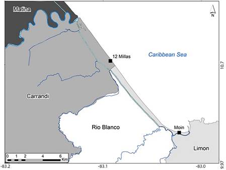
Fig. 3: Location of 12 Millas and Moín, showing the distance between different reports of deceased people by the tsunami. Matina, Carrandi, Río Blanco and Limón are districts of Limón. Basemap: Atlas ITCR (2014), Tortuguero channel digitized from Open Street Maps.
We interviewed Dr. Valerio, she issued one death certificate for one person drowned by the tsunami in Moín, this body was recovered from the sea. She also remembers at least one more person drowned certified by a colleague but was not able to remember the place. As Moín and Doce Millas are 8.5 km apart (Figure 3), both references very likely do not refer to the same two persons, and then this tsunami might have caused three or four deaths. Dr. Valerio also mentioned that she met two tourists in Limón, who had been rescued from the sea, as they almost perish in the tsunami, but did not know the exact place of the rescue.
No other tsunami had caused deaths in Costa Rica; therefore, the testimony of Dr. Valerio is very valuable, particularly as there is the only information specifically related to deaths caused by a tsunami in Costa Rica.
Other earthquakes investigated
20 December 1904 (19 December 1904 UTC)
As the 1822 earthquake, the 1904 earthquake was initially located at the Osa region by Pacheco and Sykes (1992) and relocated in the Costa Rican Caribbean coast by Boschini and Montero (1994), Camacho and Víquez (1993) and Ambraseys and Adams (1996). This relocation was done for the same reasons as the 1822 earthquake: intensity and damage reports, as well as the report of coastal uplift at Limón.
There is no information of a tsunami related to this earthquake. However, Calvert and Calvert (1917) visited the hospital at Limon in 1909 guided by Dr. Emilio Echeverría and reported: ''The coast here consists of a coral rock which forms cliffs, reaching a height of a hundred feet in some places, and flat reeds which are washed by the tide. Dr. Echeverria thought the reefs were still forming, as a certain reef now visible, although awash, was not so when he first came to the hospital'' (p. 5).
The rise on the reefs might be a sign that a tsunami was generated, but this cannot be established. Camacho and Víquez (1993) indicated this rise of the reefs is consistent with the caused by the 1991 event, confirming that this earthquake was originated at the North Panama Deformed Belt (NPDB). Also Ambraseys and Adams (1996) located them in the Caribbean coast.
The Engdahl and Villaseñor catalog (2002) locate the 1904 event at the Osa region based on Pacheco and Sykes (1992) without considering newer data. However, in personal communication with Dr. Javier Pacheco in 2020, he stated that the valid location of 1904 event is the newest one, provided by Camacho and Víquez (1993), as it was calculated with newer information than Pacheco and Sykes (1992).In newspapers of 1904, all the references of damages caused by the earthquake are concentrated at the Atlantic region of Costa Rica (Briceño, Ispizún & Martínez, 1904; Castro, 1904; ''El Temblor Por El Telégrafo Sin Hilos'', 1904; ''Los Temblores En La Línea de Limón'', 1904; ''Severe Earthquake in the City'', 1904; Saborío & Alabarta, 1904). For example several newspapers reported on the damages on the railroad that prevented the opera company to arrive to San José to performed as planned (Castro, 1904; Saborío & Alabarta, 1904).
Several newspapers reported that residents of Limon haven't felt such a strong earthquake before, like the newspaper El Día: ''It was an atrocious thing and people that have lived here for like 30 years assured me that they have never felt anything like it'' (''Los Temblores En La Línea de Limón'', 1904, p. 2; translated by the authors).
Also, the Limon Weekly News, which was ''the only paper published in English in Costa Rica'': ''At midnight on Monday the entire city was thrown into a state of alarm by a very severe shock of earthquake, the like of which had never been experienced in Port Limon by the oldest inhabitant'' (''Severe Earthquake in the City'', 1904; p. 4).
From Panamá the newspaper ''El Noticiero'' reported that there were damages in Bocas del Toro:
Immediately after the earthquake, in a communication from Bocas del Toro to Limón through the wireless telegraph, mentioned that there the earthquake was of great proportions. Some buildings were damaged. The residents are extremely alarmed.
From the warship 'Dixon' anchored in Bocas del Toro waters, they communicate also by the wireless telegraph, that it felt very strong on board and the marines were scared (''El Temblor Por El Telégrafo Sin Hilos'', 1904, p. 3; translated by the authors).
But no damages were reported in Chiriquí, the Panamá province at the border with Costa Rica in the Pacific coast (Camacho & Víquez, 1993).
Also, there are no references at all to damages in the south part of Costa Rica, in a similar way as done for the 1953 event. As opposite, newspapers entries related with the 1941 earthquakes include wide reports of damages in the south part of the country and only minor reports for the Atlantic region.
7 January 1953
On 7 January 1953 a Mw=5.9 earthquake shook Costa Rica with epicenter in Limón city (Boschini & Montero, 1994) and maximum intensity of VIII, newspapers reported people falling down in the streets due to the shaking (Martín, 1953). The earthquake caused important damages in the city and subsidence of several inches at several parts of the airstrip (Borrasé & Durán, 1953). Residents of Limón reported rumbles the days previous to the earthquake (''La United Fruit Company Informa Sobre El Terremoto de Limón'', 1953; Martín, 1953). There are no other reports of this earthquake along the Caribbean coast and neither tsunami reports, as the paper rolls of the tide gauge of that year are lost.
Conclusions
Costa Rica Caribbean coast has experienced at least four local tsunamis since 1746. There are no records of distant tsunamis and no marigrams, even when Limon tide gauge was installed in 1941. The 1991 tsunami caused at least three deaths, being the one with the largest impact for both Costa Rican shores. Also, the 1991 tsunami had the maximum number of register locations in the country.
Nowadays, Costa Rica has only one tide gauge at the Caribbean coast, located in JAPDEVA port. The authors consider necessary to have more tide gauges at this coast to register future tsunamis. Tsunami marigrams are required for numerical model verification and to better understand the tsunami physical response of the region.
In regions with infrequent occurrence of tsunamis like the Caribbean basin, tsunami historical records become key on acknowledging and assessing the threat. Even when a recurrence time cannot be established, it is for sure that a tsunami will impact again the Caribbean coast of Costa Rica, thus tsunami preparedness should be increased, both by national and local authorities and by coastal communities.

