


 Inglês (pdf)
 Artigo em XML
 Referências do artigo
 Enviar este artigo por email
 Citado por SciELO
  Similares em
SciELO
Similares em
SciELO 
 Permalink
Introduction
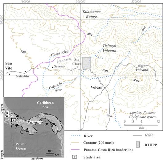
Bajos de Totuma Hydropower Plant (BTHPP) study area is located in west Panama, near to Costa Rica-Panama border line (Fig. 1), the project area is located on the north side of national road 415 some 25 km west from the town of Volcán. The region is part of the Talamanca Mountain Range, where the Tisingal and Tisingal volcanoes stand out and BTHPP develops on southwest flank of the Tisingal volcano.
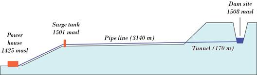
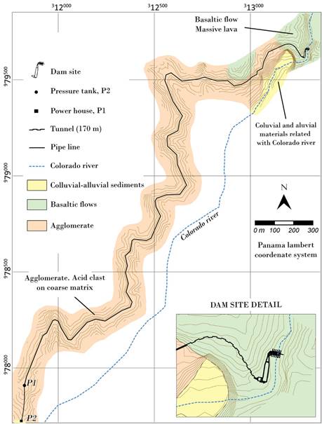
The hydraulic scheme of the project includes a small intake in the Colorado River at elevation 1,508 m.a.s.l., an initial conduction tunnel about 170 m long, a superficial pipeline about 3140 m, pressure tank, an approximately 600 m long penstock, a powerhouse located on the right bank of the Colorado River at 1,455 m.a.s.l (See schematic elevation on figure 2) elevation and generates around 5 MW of power.
The main objective of the geological investigation conducted by Geotest S.A. during October-November 2013 was to produce a detailed geological map of the project area, with the purpose of identify types of rocks and any other materials present in the area of influence of the project. Main geotechnical parameters were obtained and regional volcanic and seismic hazards were evaluated throughout the investigation. Geophysical surveys (ASTM D-5777 high-resolution seismic refraction tomography) were conducted to support field data.
Regional Geology
The study area (Chiriquí highlands) is composed mostly by Neogene to Quaternary age volcanic and sedimentary rocks. The most prominent volcanic range (that is an eastward extension of Costa Rican Talamanca range) includes the Colorado-Tisingal and Tisingal complex volcanoes, which are among the highest mountains in Panama and most of the rock formations in the area are derived from these groups of volcanic complex activity. Older volcanic and sedimentary rocks in the area are from early Pliocene age and probably older Paleogene, according to Geological Map of Panama, 1991. Those formations include andesitic lavas, breccias, and felsic to intermediate intrusive bodies in form of intravolcanic batholiths and dikes (Camacho, 2009) and sedimentary rocks associate with neritic sedimentation during Upper Miocene.
The last major volcanic activity in the Colorado-Tisingal complex was dated at 1.6 Million years before present (MYBP) (Restrepo, 1987), in which most of the southwest flank of the volcano collapsed to form the present caldera and domes located in its horseshoe-like crater. After this volcanic (Tisingal event), the area was covered by pyroclastic deposits (mostly felsic or pumiceous volcanic tuff), and some basaltic lava flows were emplaced into existing river canyons (intracanyon lavas). This is the case of Colorado River in the intake area. Younger (Quaternary) basaltic lava flows, pumice tuff, and massive debris avalanche deposits are present in the project area, as well as very coarse alluvial deposits near the power house site and Colorado’s river.
Figure 3. It shows a schematic interpretation of the Colorado Tisingal Volcano as can be seen in Google Earth data (elevation data) and its relation with the Neogene bedrock. As shown, BTHPP is located in the remainders of the southwest flank of this volcano, in the main flow area of the debris generated by the Tisingal event (1.6 MYBP).
Despite the few references on the regional geology and no availability of local geological maps other than regional maps (Morel, Gardner, Fisher, Idleman y Zellner, 2013), some effort was made to contribute to the understanding of the stratigraphy of the west flank of the volcano as stated in this work. The complexity of this area is related not only to the fact that it is located right in the flow path of a major volcanic collapse and lateral eruption, but that most of the rocks present in the BTHPP have been displaced and/or are not located in their original emplacement; this is, most of the rocks in the project are probably allochthonous.
Regional Tectonics
Tisingal complex volcano (and BTHPP) is located on Panama Micro plate in the north end of the Panama Fracture Zone (PFZ), and above the Cocos-Nazca slab tear (Morel et al., 2013),. PFZ is one of the most relevant structures in the tectonic setting of this area and its relationship with Cocos, Nazca, and Panama micro-plate determines the tectonic and seismic features of this region.
Three major tectonic plates are interacting in the so called “triple junction” between Cocos, Caribbean, and Nazca Plates in this portion of southern Central America and major regional stress derived from the Cocos and Caribbean Plates (SW-NE) produces deformation in a general NW-SE direction, which is the main direction of major morphological units in the area, which are, Talamanca range, coastal range, volcanic sequence in Chiriquí Highlands, and major costal fault zones (see Cowan, 1995). Some N-S structures are related to the Panamá Fracture zone; this is probably the case of local faults in the study area.
There are no evidences of subduction of Cocos Plate beneath the Panama micro-plate, but some incipient subduction of Caribbean Plate beneath Panama micro-plate has been interpreted from recent Changuinola area seismicity. Figure 4 shows the general tectonic setting of western Panama. As shown, Tisingal and Tisingal volcanoes are located on the north end of the Panama Fracture Zone (PFZ), and in an Eastward projection of Talamanca range in Costa Rica.
As shown, major earthquakes (Mw>6) are located along Panama Fracture Zone and associated to the subducted portion of Cocos Plate beneath the Caribbean Plate in the west side of PFZ. Table 1 lists historic earthquakes that can be related to PFZ, as stated by Camacho (2003).
Seismic hazard for BTHPP
According to available sources (Camacho, 2009; EPR, 2003), maximum peak ground acceleration expected for a 25-year return period varies between 0.3g < Aef <0.5g from seismicity generated in the PFZ. However, some low-magnitude shallow events (Mw< 5.7) may produce intensities up to VIII MM in the project area. (Correlations with Costa Rica´s nearby seismic zoning). Colegio Federado de Ingenieros y de Arquitectos de Costa Rica (2010) indicates that for the BTHPP area, a peak ground acceleration with a 500-year exceedance probability must be expected in the Aef = 0.33g range. Shear-wave velocity (Vs30) and period (from MASW) are discussed further in this work. It is strictly suggested that any civil or structural design for the project must be in compliance to the Reglamento Estructural Panameño (Junta Técnica de Ingeniería y Arquitectura, 2014).
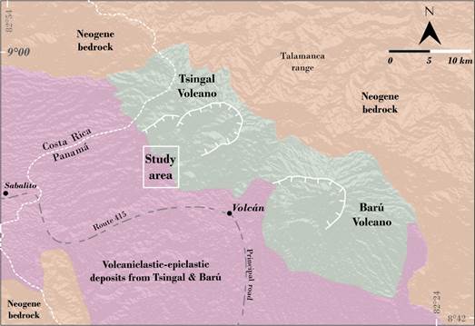
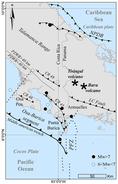
Table 1: Historic earthquakes associated to PFZ (Camacho, 2003).
| EVENT N° | Date | Source | Damages | Mw. |
| 1 | 1854 | - | Strongly felt. | > 6.5 |
| 2 | 1859 | PFZ | Damages in Boquerón, Chiriquí | > 6.5 |
| 3 | 1871 | PFZ | Felt in David | > 6.5 |
| 4 | 1933 | PFZ | Damages in Puerto Armuelles | 6.6 |
| 5 | 1934 | PFZ | Major damages in David and Puerto Armuelles | 7.6 |
| 6 | 1934 | Canoas Fault | Small damages in Puerto Armuelles | 6.7 |
| 7 | 1949 | PFZ | Damages in Puerto Armuelles | 6.6 |
| 8 | 1962 | PFZ | Damages in David and Puerto Armuelles | 6.7 |
| 9 | 1979 | PFZ | Damages in Puerto Armuelles | 6.4 |
| 10 | 2002 | PFZ | Major damages in Puerto Armuelles | 6.5 |
Volcanic hazard for BTHPP
A Tisingal volcano major eruption was dated from 1.6 MYBF (Restrepo, 1987). A massive collapse of the SW flank of the volcano produced some 8 to 10 km3 of debris avalanche deposits along SW flank of the volcano and originated most of the present geomorphology of the area. This kind of catastrophic event is unlikely to happen in the present, and geological evidences indicate that this complex volcano is in its terminal phases of activity because of Eastward migration of magma to Tisingal volcano.
Residual hydrothermal activity can be observed in Los Pozos area, some 1 km north of BTHPP intake site, on the left bank of Colorado River. This hydrothermal activity may be related to S-N faulting along Colorado River. Hydrothermal activity can be observed as small hot springs and isolated hot mineral springs flowing through recent lava in Los Pozos area, as shown in figure 5.
Tisingal and Barú volcanoes show the same kind of mega structure, this is, rapid dome growing originating massive collapse of one side of the mountain and massive debris avalanches associated with lateral pyroclastic flows. Despite discussions about recurrence periods of Barú volcano eruptions, this is an active volcano, and its last activity was dated between 1,300- and 1,200-years BC (EPR, 2003). In the event of an eruption in the Barú volcano, ash fall and probably volcanic bombs could be expected in BTHPP. Some fresh pumiceous volcanic tuff in Los Pozos area suggests a volcano source external to Tisingal.
Geology of BTHPP
Geological and geotechnical aspects of the project scheme are discussed in this chapter (Fig. 6), based on field observations, field data collection, geophysical support, and core-drilling data from power house and surge tank locations (P-1 and P-2).
It was determined that a stratigraphic sequence composed of a rocky agglomerate basement, overlain by a basaltic lava flow, both units associated with the activity of the Tisingal volcano and, finally, alluvial deposits associated with the fluvial activity of the Colorado River, was observed (figures 6 and 7).
The agglomerate (is the) unit (that) outcrops in all the extension where the conduction pipe and part of the tunnel is located, it is composed by a well welded sandy matrix of medium granulometry, which includes blocks of up to 1 m in diameter, with varied composition , being the granodiorite blocks those that occur with greater frequency (figure 7 A and 7B).It was observed that the previous unit is overlying by a basaltic lava flow, which filled the preexisting topography and appears in the upper part of the study area, where it was installed. This flow is composed of basalts of dark tonality, with columnar disjunction, aphanitic texture and in general with very little evidence of alteration (figure 7C and 7D). Over these materials it was observed, especially in the lower part of the study area, where the power house will be installed, a colluvial-alluvial deposit, with blocks up to 5 m in diameter, which suggests a very high energy environment, with a clayey matrix and with a thickness greater than 20 m (figure 7E and 7F).
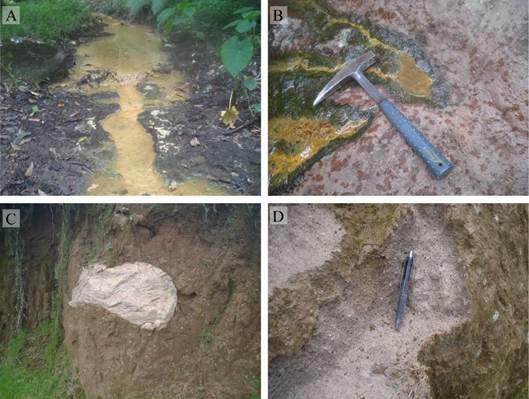
Fig. 5: A-B: hydrothermal (low temperature, low pressure) water flowing through lava. Sulphur and iron oxide deposits are present. C-D: fresh pumice ash deposits and 1-m long volcanic bomb in the upper Colorado River (Los Pozos area). It is not clear if this volcanic tuff was originated in Barú volcano.
Geotechnics aspects of BTHPP
Colorado River intake
The water intake consists of a small diversion dam located in the Colorado River at elevation 1,508 m.a.s.l. At this site, both river bed and lateral slopes are conformed by a massive to columnar, dark color, very hard basaltic lava flow and the total thickness of this basalt formation is over 50 m, as it was seen in the canyon of the river.
The rock is sound, two sets of joints are present plus a random joint set distributed into the mass (roughly sugar cube type), most are discontinuous, with no fills or just surface staining and rock mass in general seems to have low permeability. RQD was estimated in the 50 to 75 % values from joint measurements. RMR value of 65 was defined for this rock mass, which is a class II mass, good quality rock.
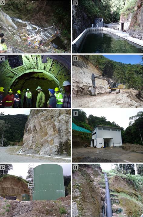
Permeability of the rock mass at dam site have low relevance due to the size of the diversion dam, this is 2.5 m above river bed. This dam was built directly on the river bed without any diversion of the flow (See Figure 8). No access was possible to build to this site so the construction process was performed by a crane settled about 80 m above the left margin of the river.
Tunnel
Figures 2 and 6 show tunnel cross-section from intake to the start of pipeline conduction, this section of BTHPP is 100-m long, and most of it was excavated into volcanic agglomerate rock mass, with a short distance on basaltic lava flow. As two very different quality rock masses will be excavated for the tunnel construction, most of this geotechnical investigation was focused in determining main parameters for evaluation of Q index and preliminary support design for the tunnels. The main difference between both rock masses is that the basaltic rock mass has not been disturbed by tectonism as agglomerate of the Tisingal event. Agglomerate rocks are moderate to intensely weathered on the surface but sound rock can be found some 25 m deep. At least 2 joint sets are present, most of them undulated to rugose, with secondary infill of soft minerals, crushed rock is exposed in shear zones, and most of the rock mass has low to very low permeability due to the presence of clay as a byproduct of weathering and also due to secondary hydrothermal alteration.
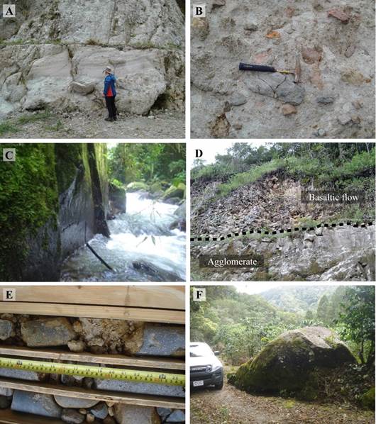
Fig. 7: A. Agglomerate outcrop, B. Agglomerate detail. C. Basaltic lava aspect, D. contact between basaltic lava and agglomerate, E and F Alluvial-colluvial deposits at power house.
Basaltic rock mass is classified as class C, fair condition rock mass, while agglomerate rock mass is classified as class D, poor to fair rock mass. Both cases are located on area (1) of the support chart, but according to field observations it is recommended to utilize area (4) for initial and terminal sections of tunnel where weathered agglomerate is present. For tunnel excavation in agglomerate rocks, reinforced shotcrete and systematic bolting was considered in the final design.
Pipeline conduction
As shown in figure 2 and 6 (geological map), pipeline conduction has been proposed along steep slopes located between Fila de Colorado and the right bank of the Colorado River. This area is composed of volcanic agglomerates originated during Tisingal volcano lateral explosions (Tisingal events). Most critical slopes along this conduction alignment reach some 1:1 slope, and there is a planar trend in the major slope near the final half of the alignment.
Seismic horizontal acceleration of Ah= 0.33 g was introduced to this model and a critical 1:3 slope was modeled as shown, a safety factor of Sf = 1.8 was obtained in this preliminary analysis, which means acceptable stability conditions for the proposed excavation and back slope, this is, uphill slopes. Figure 8 shows process and finishing of the pipeline slopes. In some cases, those slopes have more than 80 m high.
Surge tank and penstock
Despite no data is available to define agglomerate thickness, it is probable that more than 200 m of pyroclastic materials are present in the area. Geophysics and drilling programs were not able to reach the total thickness of those materials. However, surge tank and penstock are surficial works that not require more than 20 m investigation depth for its foundation design.
The lower portion of the penstock is located on weathered lower volcanic tuff. Somehow this volcanic tuff is slightly denser than the weathered agglomerate in the surge tank area, as suggested by seismic profiles on the lower penstock area.
Bearing capacity of Qad = 135 KN/m2 for foundation at some 8-m depth was determined for surge tank location. For any penetration of the foundation into this layer, corresponding overload (Gamma x H) should be added. Figure 8G and 8H shows surge and penstock as where builded.
Power house
Power house proposed site for THPP is located on very thick and very coarse alluvial terraces on Colorado River right bank. Mega blocks, blocks and very coarse rock fragments in a sandy gravel matrix are present in this deposit. According to P1 drill hole, more than 20 m-thick alluvial deposit is present at power house site and no bedrock was detected by seismic tomography in power house location to maximum investigation depth (20 m). Overburden silty gravel material in this site have a Vp = 402 m/s, while main alluvial deposit has a Vp = 1,475 m/s, Vs = 707 m/s. Allowable bearing capacity estimated for power house foundation in this site is Qad = 305 KN/m2. Figure 8 shows the power house in its operative stage.
Final Comments
BTHPP is located in a complex volcanic geological setting. Many different types of volcanic rocks and related materials are present along project scheme. It is highly probable that most of those materials were originated during Tisingal volcano major explosive activity some 1.6 million years ago, so probably most of the rocks in the area are allochthonous and/or related to major Tisingal lateral explosion and resulting pyroclastic flow some 1.6 million years ago.
The stratigraphy of the area is was clarified during this investigation. The relationship between Quaternary/Neogene volcanic agglomerates and the seemingly undisturbed basaltic younger lavas in the Colorado River was determined as well. Degree of weathering in volcanic agglomerate bedrock is a major limitation to define continuity of lithology and structure of this rock mass along project schemes. Despite major stratigraphic uncertainties, this investigation contributes to a relative fair understanding of the geotechnical conditions and parameters present in every project proposed work, this is, intake, tunnels, conducting pipelines, surge tank, penstock, and power house.
Seismic or volcanic hazards seem not to be a major concern for the project design, construction and operation, but induced unstable conditions generated by project construction seems to be a major concern especially for the pipeline conduction line.

