


 Inglês (pdf)
 Artigo em XML
 Referências do artigo
 Enviar este artigo por email
 Citado por SciELO
  Similares em
SciELO
Similares em
SciELO 
 Permalink
Introduction
Reconstructing past fluctuations of tropical glaciers has garnered significant attention in recent decades (Seltzer, 2001; Smith et al. 2005; Licciardi et al. 2009; Jomelli et al. 2014). Compared to the glaciers in the middle and high latitudes, tropical glaciers have distinctive mass balance characteristics due to the relative constancy of mean daily temperature: all-year ablation on the lower parts of glaciers and cyclical accumulation affected by the migration of the Intertropical Convergence Zone (Kaser & Osmaston, 2002; Benn et al. 2005). Investigating the pattern of past glaciations in tropical mountains is of critical importance for understanding trends in tropical paleoclimate and their forcing mechanisms. In the Cordillera de Talamanca of Central America, glacial landforms left behind by past glaciers record the extent and timing of glacial fluctuations associated with Quaternary climate change (Hastenrath, 1973, 2009; Bergoeing, 1977; Barquero & Ellenberg, 1986; Wunsch et al., 1999; Orvis & Horn, 2000; Lachniet & Seltzer, 2002; Lachniet, 2004, 2007; Lachniet & Vazquez-Selem, 2005; Lachniet et al., 2005; Castillo-Muñoz, 2010). Detailed mapping of these landforms would provide an important dataset to help reconstruct paleoclimate and environmental change in this tropical highland.
Previous studies of glacial geomorphology in the Cordillera de Talamanca of Central America have focused mainly on the Chirripó massif. Glacial landforms in this area have been described in the forms of field notes, photos, and landform interpretations and maps based on available topographic maps and air photographs (Hastenrath, 1973; Bergoeing, 1977; Barquero & Ellenberg, 1986; Orvis & Horn, 2000; Lachniet & Seltzer, 2002; Lachniet et al., 2005). For example, Orvis and Horn (2000) provided detailed maps and glacier reconstructions for the Valle de las Morrenas, and Lachniet and Seltzer (2002) and Lachniet et al. (2005) mapped the overall glacial landform distribution, including moraines, tills, and the maximum glacial extent, for the entire Chirripó massif. However, the quality and accuracy of these landform interpretations and maps are limited by the resolution of the topographic maps and by the number of field sites that could be visited and checked by the investigators. In addition, the mapped glacial features were likely overgeneralized and some features mapped by different investigators were not exactly matched in detail.
The availability of digital elevation models (DEMs) and high-resolution satellite images (such as sub-meter to meter resolution DigitalGlobe or CNES/Astrium imagery available in Google Earth) provide a unique opportunity to map glacial landforms in remote areas. With these new datasets and advanced techniques in geographic information systems (GIS), new efforts to map glacial landforms have been carried out in various highlands of the world, such as the Tibetan Plateau, Tian Shan, and other Central Asian mountains (e.g. Heyman et al., 2008; Morén et al., 2011; Fu et al., 2012; Stroeven et al., 2013; Blomdin et al., 2016; Chen et al., 2016; Li et al., 2016). These mapping efforts have significantly improved our understanding of the extent of past glacial fluctuations. However, no work of this kind using high-resolution satellite images in Google Earth and recently updated DEMs has been published for the Cordillera de Talamanca of Central America.
We mapped glacial landforms on the Chirripó massif of the Cordillera de Talamanca where landform field descriptions, photos, and age constraints are available (Hastenrath, 1973, 2009; Orvis & Horn, 2000; Lachniet & Seltzer, 2002; Lachniet, 2004, 2007; Lachniet & Vazquez-Selem, 2005; Lachniet et al. 2005). Glacial landforms were mainly identified and delineated in Google Earth with the sub-meter resolution CNES/Astrium imagery and in ArcGIS based on the examination of a set of topographic parameters, such as slope, hillshade, and curvature, using a 30 m Shuttle Radar Topography Mission (SRTM) DEM, which has been recently available from the United States Geological Survey (USGS). We also checked available field notes, photos, and landform maps from our field work and previously published literature (Orvis & Horn, 2000; Lachniet & Seltzer, 2001, Lachniet, 2004, Lachniet et al. 2005) to validate and refine the delineated landform boundaries. Our updated map provides a framework to reconstruct the pattern of past glacial fluctuations in this key tropical mountain area. It also provides a resource for future studies of soils and vegetation on the massif, and may assist the Costa Rican government in managing resources in Chirripó National Park. Finally, students and tourists who visit the park may find the map useful.
Study Area
The Cordillera de Talamanca is a northwest-southeast trending mountain range in Costa Rica and Panama (Figure 1a). In Costa Rica, the highest peak of this mountain range is Cerro Chirripó (3819 m; 9.4841° N, 83.4887 W) (Figure 1b) close to the center of Chirripó National Park. Neotropical páramo vegetation (dominated by the miniature bamboo Chusquea subtessellata, other grasses, and shrubs) covers the peaks and surrounding highlands above the treeline (Kappelle & Horn, 2005, 2016). The mean annual precipitation and temperature are about 2581 mm and 8.5°C, respectively, based on the record between 1971 and 2000 from the Cerro Páramo meteorological station (3466 m; 9.5600 °N, 83.7529 °W), about 30 km west of Cerro Chirripó (Lane et al., 2011).
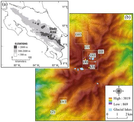
Fig. 1: (a) Location of the Chirripó massif in the Cordillera de Talamanca in Costa Rica (modified from Orvis and Horn (2000)). (b) Shaded relief and contour map of the study area derived using the 30-m SRTM DEM: (1) Valle de las Morrenas; (2) Río Talari Valley; (3) Cerro Chirripó; and (4) Loma Encerrada. The contour interval is 50 m. The four white boxes represent the approximate extents of the four photos in Fig. 2: (i) Fig. 2a; (ii) Fig. 2b; (iii) Fig. 2c; and (iv) Fig. 2d.
Our study focuses on the glacial landforms surrounding Cerro Chirripó (Figure 1b, Figure 2). Glacial features in this area have been reported and investigated since the 1950s, especially within the two valleys: the Valle de las Morrenas and the Río Talari Valley (Weyl, 1956a, 1956b; Hastenrath, 1973; Bergoeing, 1977; Barquero & Ellenberg, 1986; Orvis & Horn, 2000; Lachniet & Seltzer, 2002; Lachniet, 2004, 2007; Lachniet & Vazquez-Selem, 2005; Lachniet et al. 2005;Kappelle & Horn, 2005, 2016; Lane & Horn, 2013). Orvis and Horn (2000) proposed four glacial stages from young to old, Chirripó I-IV (Chirripó IV is the oldest), corresponding to the four moraine groups present in the cirque and down the valley in the Valle de las Morrenas. Moraines and other glacial features across the Chirripó massif were also examined by Lachniet and Seltzer (2002), who identified three moraine groups in the Valle de las Morrenas and the Río Talari Valley (Talari, Chirripó, and Talamanca from young to old), corresponding to the Chirripó II-IV moraines of Orvis and Horn (2000). A potential earlier and more extensive glacial stage (Chirripó V) was also suggested by geomorphic evidence of ice scouring atop Loma Encerrada (Orvis & Horn, 2000). The timing of the most recent deglaciation in the Valle de las Morrenas was constrained by radiocarbon ages on basal organic sediments in glacial lakes, indicating that the last glacier to occupy the valley retreated before 10 cal. ka BP (Horn, 1990; Orvis & Horn, 2000). Moraines down the valley, representing earlier glacial stages, were mainly formed during the Last Glacial Maximum (LGM) and the cooling phases, based on recent cosmogenic 36Cl surface exposure dating results (Potter et al., 2019).
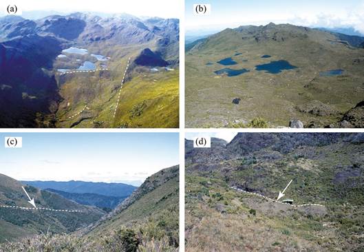
Fig. 2: Field photos of glacial landforms in the study area. (a) View from a small airplane of landforms in the upper Valle de las Morrenas, with glacial lakes in the cirque and moraines in the cirque and valley. (b) Glacial lakes within the cirque in the Valle de las Morrenas. (c) The lowest lateral moraine in the Valle de las Morrenas. (d) A small terminal moraine in the Río Talari Valley. Photo credits: Luis González Arce (a), Chad Lane (b), Sally Horn (c, d).
Methods
Data sources
We used Google Earth, SRTM DEM, previously published maps of glacial geomorphology (Orvis & Horn, 2000; Lachniet & Seltzer, 2002; Lachniet et al., 2005), and our field notes to map glacial landforms in this area. In recent decades, Google Earth has been adopted as a popular platform for landform interpretation, and its 3-D interactive visualization enhances the use of available DEMs and satellite imagery in geomorphological mapping (Sun et al. 2012; Yu & Gong, 2012). Although the spatial resolution of the imagery varies from place to place in Google Earth, the image scenes in Cordillera de Talamanca were updated to the sub-meter CNES/Astrium imagery after 2016. Such high-resolution imagery allows for the identification and delineation of glacial landforms in Google Earth.
The other dataset that we used is the 1 arc-second (30-m) SRTM DEM (version 3, https://lta.cr.usgs.gov/SRTM1Arc), which became available for our mapped area in 2015. Before 2015, only the 90-m resolution SRTM DEMs (versions 1 and 2) were available for areas outside of the US. This DEM was used to derive the slope, curvature, hillshade, flow direction, and flow accumulation using standard ArcGIS tools to help revise the glacial landforms delineated in Google Earth.
Mapping procedure
We manually digitized glacial landforms, including lateral and terminal moraines, tills, glacial valleys, glacial lakes, horns, arêtes, and nunataks, based on the sub-meter CNES/Astrium imagery in Google Earth. Horns were digitized as point features and arêtes as polyline features; all other landforms were digitized as polygon features. After finishing the digitization, the digitized features were exported as a KMZ file from Google Earth.
We converted the KMZ files into shapefiles in ArcGIS and overlaid them with the SRTM 30-m DEM. We applied the Swiss-style hillshade method (Jenny & Hurni, 2006) to generate the shaded relief map and overlaid it semi-transparently with other DEM-derived topographic parameters, such as slope, curvature, flow direction and accumulation, to enhance the contrast of the topography and landforms. We also georeferenced and digitized the available glacial geomorphological maps (Orvis & Horn, 2000; Lachniet & Seltzer, 2002; Lachniet et al., 2005). The DEM, its derived topographic parameters, and digitized available landforms maps helped confirm and refine the delineated lateral and terminal moraines, tills, and glacial valleys in Google Earth. For example, DEM-derived slope was used to refine the boundaries of tills because these glacial deposits are unlikely to be present on steep slopes. We used the slope map and the tills digitized from previously published maps to refine the till boundaries delineated from Google Earth. We also inverted the DEM (so that the ridges become valleys), derived flow direction and flow accumulation of the inverted DEM, and extracted major ridge lines (as streams for the inverted DEM). These derived ridge lines were then used to refine the delineated arêtes (ridges) in Google Earth. The following is the description of the mapped landforms.
Glacial valleys
Glacial valleys that have been eroded and smoothed by moving ice typically have U-shaped cross-sections, in contrast to the V-shaped valleys formed by fluvial incision (Li et al. 2001; Montgomery, 2002; Prasicek, 2014). We applied the profile tools in both Google Earth and ArcGIS to examine the cross-sections along each valley (Figure 3). The shift between the U-shaped and V-shaped sections, along with other geomorphic evidence, such as the distribution of the moraines and till deposits, was used to determine the lower ends of the glacial valleys.
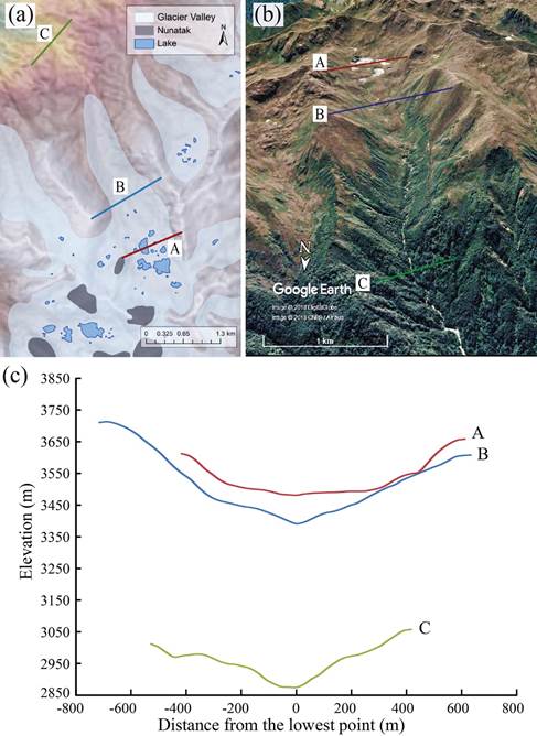
Fig. 3: Mapped glacial valleys, lakes, and nunataks around Valle de las Morrenas in color-rendered DEM (a) and Google Earth view of the region (b). Cross-section profiles (A, B, and C) are illustrated in (c) to show the U-shaped valley floor of glaciated area (A and B) in contrast to the V-shape valley bottom formed by fluvial incision (C).
Moraines and tills
We mapped lateral and terminal moraines composed of glacial deposits (diamicton) (Figure 4a). These ridge-shaped features are linear or slightly curved and typically lie perpendicular to or along the margins of glacial valleys. We examined the mapped moraine from different perspectives and used the profile tool to check the cross sections along the moraine ridge to map the boundary. We also checked the mapped moraine boundaries in ArcGIS by examining the profiles on the 30-m SRTM DEM. Multiple moraines can be identified in the major glacial valleys of the Chirripó massif.
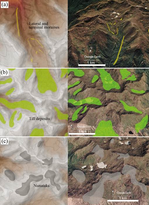
Fig. 4: Illustration of mapped landforms based on DEM and Google Earth imagery. Left panels are mapped landforms on colored SRTM DEM that is overlaid with Swiss-style hillshade effect (Jenny & Hurni, 2006). Right panels are the corresponding landforms mapped in Google Earth with adjusted perspective angle. (a) Lateral and terminal moraines in the Valle de las Morrenas; (b) Till deposits in the Valle de las Morrenas and nearby valleys; (c) Nunataks mapped in the area.
In addition to the moraines, we also mapped irregular sheets of till within the glacial valleys and cirques that formed when glaciers retreated relative rapidly without enough equilibrium pauses to form moraine ridges (Figure 4b). Lachniet and Seltzer (2002) observed two types of till in this area: lodgment till that was deposited subglacially, and ablation till that was deposited during deglaciation. We did not distinguish these two types of tills due to the lack of detailed sedimentological investigations.
Horns, arêtes, and nunataks
We also mapped horns, arêtes, and nunataks in this area. These landforms can provide useful information about the upper limit of past glaciers, especially the nunataks (Benn & Evans, 1998). A horn is a mountain peak formed by the headward erosion of multiple glaciers. We identified horns as mountain peaks with rough, unglaciated terrain surrounded by smooth, U-shaped glacial valleys in Google Earth and mapped them as point features. Horns on the Chirripó massif were typically not fully covered by ice due to the steep slopes on each side.
We mapped arêtes as polyline features that represent the crested ridges between adjacent glacial valleys. However, not all arêtes in our study area are as sharp as “knife” ridges, perhaps indicating that portions of the arêtes were covered and modified by ice in the past.
The nunataks were mapped as exposed bedrock surfaces (polygon features) that are surrounded completely by glaciers (Figure 4c). As islands that were not covered by glaciers in the past, nunataks are generally angular and jagged due to freeze-thaw weathering. These characteristics present a sharp contrast with the surrounding glacial landforms that were smoothed by glacial erosion and deposition.
Glacial Lakes
Glacial erosion and deposition usually create irregular topography within the cirque and valley. After glacial retreat, water can accumulate in depressions in the cirque, valley head, and valley bottom to form glacial lakes (Horn et al., 2005) (Figure 2a and b). In our study area, glacial lakes are distributed primarily within the cirques and valley heads. The sediments deposited within these lakes preserve important evidence to reconstruct changes in vegetation, fire, and climate in this tropical highland (Horn, 1993; Haberyan & Horn, 1999; League & Horn, 2000; Horn & Kappelle, 2009; Lane et al., 2011; Lane & Horn, 2013; Wu, 2018).
Validation and accuracy assessment
To validate and confirm the mapping results, we carefully examined of our mapped landforms in Google Earth, SRTM DEM, and on previously published maps. We mapped each landform multiple times from different perspectives in Google Earth to check if the mapped boundary is consistent. We also used GPS coordinates of sites we sampled in the Valle de las Morrenas and the Río Talari Valley for cosmogenic 36Cl surface exposure dating of moraines to help assess the accuracy of our mapped features. We overlaid the GPS coordinates of the cosmogenic 36Cl sample sites (Potter et al., 2019) with the mapped moraine polygons in these valleys to check if the sample points are contained within the moraine polygons. Although this method cannot be used to evaluate the extents of the mapped moraines, it can help confirm the locations of the mapped moraines.
Results and Discussion
The GPS coordinates of most sites (except one from the ridge close to Loma Encerrada) from which we collected samples for cosmogenic 36Cl surface exposure dating are within the mapped boundaries of moraines, indicating relatively good quality of the mapped features in terms of their locations (Figure 5). However, this quality assessment is limited to the moraines. In addition, these sample sites only help confirm the locations, rather than the extents, of these mapped moraines. In general, the delineated horns, arêtes, and glacial lakes would have relatively high accuracy due to the availability of high-resolution, sub-meter CNES/Astrium imagery in Google Earth. In contrast, the mapped boundaries for glacial valleys, lateral and terminal moraines, till deposits, and nunataks may have relatively large uncertainties due to the fuzzy nature of the boundaries of these landforms.

Fig. 5: Mapped glacial features, including lateral and terminal moraines, tills, and glacial lakes, in the Valle de las Morrenas and the Río Talari Valley. The topography is represented with a shaded relief map of the 30-m SRTM DEM based on the Swiss-style hillshade method (Jenny & Hurni, 2006). The contour interval is 50 m. The red dots are sites sampled for cosmogenic 36Cl surface exposure dating; for the present study these positions were used to help validate the locations of moraines.
Figure 6 illustrates our mapped glacial landforms in the Chirripó massif of the Cordillera de Talamanca, Costa Rica. In the Valle de las Morrenas, we also digitized and refined the glacial extents for the three glacial stages (Chirripó II, III, and IV) proposed by Orvis and Horn (2000). The mapped glacial valleys cover roughly 22.1 km2. This glacial coverage likely represents the minimum extent of the maximum glaciation, for two reasons. First, some lower sections of glacial valleys might have been eroded by postglacial fluvial processes, so no longer appear smoothed. Also, the use of the division between smoothed and rough rocks to delineate past glacier extent ignores the fact that glacial plucking might produce rough surfaces. For example, cirque headwalls are usually plucked by the ice that covers all but the steepest parts. Within these glacial valleys, we mapped 11 lateral and terminal moraines and 24 areas of till deposits. We also mapped 13 horns, 23 arêtes, and 6 nunataks. For glacial lakes, we mapped 66 of them with a total surface area of 0.35 km2.
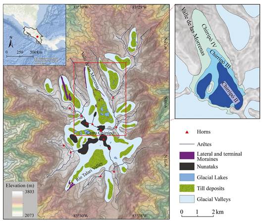
Fig. 6: Glacial geomorphological map of the Chirripó massif of the Cordillera de Talamanca, Costa Rica. The background topography is a shaded relief map created using the Swiss-style hillshade method (Jenny & Hurni, 2006) based on the 30-m SRTM DEM. To enhance the visualization of the topography and landforms, this shade relief map is overlaid with a semi-transparent grey-scale slope layer and a 50-m interval contour line map created by the DEM. An overview map (top-left corner) is provided to illustrate the mapping location in Central America. The upper-right part is a map of glacial extents of the three proposed glacial stages in the Valle de las Morrenas (Orvis & Horn, 2000) (modified in Google Earth and ArcGIS).
Cosmogenic 36Cl exposure ages from moraines in the Valle de las Morrenas (Potter et al., 2019) and previous radiocarbon ages from basal sediments of the glacial lakes within the cirque (Orvis and Horn, 2000) suggest that the Chirripó massif experienced a major glacial advance during the LGM followed by several retreat/standstill phases. The glaciers had disappeared from this highland by ~10 cal. ka BP. Therefore, this map mainly records the extents of glacial advance and retreat/standstill phases from the LGM to early Holocene in this highland of Central America.
Conclusions
In this paper, we present an updated glacial geomorphological map of the Chirripó massif in the Cordillera de Talamanca, Costa Rica. Glacial landforms are identified and delineated using Google Earth high resolution imagery (the sub-meter CNES/Astrium imagery) and the 30-m SRTM DEM, and compared and validated using previously published maps and field notes, photos, and sample sites. Specifically, we mapped a set of glacial landforms, including glacial valleys, lateral and terminal moraines, till deposits, glacial lakes, nunataks, arêtes, and horns. Together the mapped glacial features cover roughly 22.1 km2, likely representing the minimum extent of the maximum glaciation. Combined with our recent cosmogenic 36Cl surface exposure ages from the moraines and previously published radiocarbon ages from lake sediments, this map represents the extents of glacial advance and retreat/standstill phases from the LGM to early Holocene and provides an important dataset to help reconstruct paleoclimate and paleoenvironments in this tropical highland.

