


 Articulo en XML
 Referencias del artículo
 Enviar articulo por email
 Citado por SciELO
  Similares en
SciELO
Similares en
SciELO  uBio
uBio 
 Permalink
Revista de Biología Tropical
versión On-line ISSN 0034-7744versión impresa ISSN 0034-7744
Rev. biol. trop vol.53 supl.1 San José may. 2005
A Geographic Information System (GIS)analysis for trace metal assessment of sediments in the Gulf of Paria,Trinidad
Yosha Ragbirsingh &Wendy Norville
Information Technology Department,Institute of Marine Affairs,PO Box 3160,Carenage Post Office,Republic of Trinidad and Tobago;yragbirsigh@hotmail.com;wnorville@ima.gov.tt
Received 15-I-2004. Corrected 15-I-2004. Accepted 29-III-2005.
Abstract:The Gulf of Paria is a semi-enclosed shallow basin with increasing coastal development activities along Trinidad s west coast.Sediments present a host for trace metal pollutants from overlying waters,therefore determination of their content is critical in evaluating and detecting sources of marine pollution.This paper presents a Geographic Information System (GIS)analysis of geochemical assessment for trace metals in coastal sediments of the Gulf of Paria.This GIS approach facilitates interpretation of the spatial relationships among key environmental processes.The GIS development involves the integration of spatial and attribute data pertaining to bathymetry,current systems,topography,rivers,land use/land cover and coastal sediments.It employs spatial interpolation and retrieval operations to analyze the total trace metal concentrations of aluminum,copper and lead in the sediments and the clay-enriched sediments,to determine whether they are related to sediment type or are affected by the discharge from anthropogenic sources.Spatial distribution modeling of element concentrations are produced to indicate contamination plumes from possible anthropogenic sources such as rivers entering the Gulf of Paria,and to reveal potential hot spots and dispersion patterns.A direct spatial correlation between clay-enriched sediments and high concentrations of aluminum and lead is detected,however regions of high concentrations of copper and lead indicate a relationship to anthropogenic sources.The effectiveness of GIS for visualization, spatial query and overlay of geochemical analysis is demonstrated.
Key words:Geographic Information System,spatial interpolation,geochemical analysis,trace metal pollution, Gulf of Paria.
The Gulf of Paria is the focus of increasing urban and industrial development.Past studies have shown that elevated levels of metals (Chang-Yen and Hall 1986)and petroleum residues associated with oil production or refining activities (Agard et al.1988) exist in sediments located within the vicinity of established industries in the Gulf of Paria.Coastal sediments near to industrial and urban areas are commonly contaminated with heavy metals (Erlenkeurser et al. 1974).This kind of contamination may cause significant damage to sensitive ecosystems, decrease biodiversity,and cause reduction in fishing,tourism and other related economies (Rees and Williams 1996).
Sediments in coastal shallow water (0-100 m)contain historical records of anthropogenic supplied sediment material (Schmidt and Reimers 1991),because ultimately,marine sediments serve as a sink for heavy metals discharged into the aquatic environment (Luoma and Bryan 1981).The concentrations and distributions of trace metals in sediments can play a vital role in detecting pollution sources in aquatic systems (Frostner and Wittman 1979).
Over the past decade environmental geochemical investigations and mapping have been initiated by different countries to improve understanding and awareness of the adverse effects of urbanization and industrialization on the environment.One of the main problems in geochemical mapping lies in the difficulty in distinguishing the signals derived from natural sources and those generated due to anthropogenic activities (Selinus and Esbensen 1995). Currently,Geographic Information Systems (GIS)are being used successfully for visualization and spatial analysis of geochemical data sampled for this anomaly problem to derive intelligent conclusions (Zhang et al.1999). Trace metal contents are plotted and interpolated, then overlayed with various pollution and land use datasets for the same region under study for a desktop environmental geochemistry analysis.The critical role of the GIS is in separating the anomalies associated with the natural mineralization process and identifying trace metal characteristics,thus addressing one of the major hindrances to successful geochemical assessments.
The wide use of GIS in environmental modeling and analysis includes:atmospheric; hydrological;land surface and subsurface processes;biological and ecological modeling;and risk and hazard studies (Goodchild et al.1992). A GIS has capabilities to simulate and analyze spatial patterns of environmental phenomena, such as exploratory investigations of the spatial inter-relationships between datasets during the course of geological research in understanding regional geochemical and geophysical signatures of certain sediment types (Bonham-Carter 1994).GIS is becoming one of the most important tools for studying environmental geochemistry problems (Zhang and Selinus 1998). Various studies have conclusively determined whether observed mineralization is due to natural sources or due to anthropogenic activities with the aid of GIS (Selinus and Esbensen 1995,Kelly et al.1996,Nasr et al.1997,Cheng 1999,Zhang et al.1999,Goncalves et al.2001, Zhang and Wang 2001).
This paper provides a GIS analysis for trace metal assessment of sediments in the Gulf of Paria.The objective is to establish spatial correlations between clay sediment distributions and total trace metal concentrations of aluminum (Al),copper (Cu)and lead (Pb).Further,it determines whether observed anomaly is due to natural geology (sediment grain size)or is affected by the discharge from anthropogenic sources.
Trace Metal Transport
Trace metals are introduced into the environment from both natural and anthropogenic sources (Presley 1997).River input is the dominant source of trace elements to the near-shore marine environment.However,in specific locales,rainfall and particulate fallout may also be important sources.They are transported in the dissolved fractions as hydrated ions, inorganic ion pairs and complexed with dissolved organic matter.In the particulate fraction they are transported by: precipitation on clay sediment surfaces and detrital particles;adsorption on clay minerals and hydrous oxides of iron and manganese;co-precipitation with iron and manganese in hydrous oxide coatings of detrital particles;bound within organic particulates and bound within the crystalline lattice of sediments (Troup and Bricker 1975).
Trace metal content is determined by the granulometric composition of sediments (Szefer et al.1995,Naidu et al. 1997, Presely 1997). Trace metals tend to be concentrated on fine-grained clay enriched sediments (Moussa 1983, Ridgway and Stevenson 1996).Fine grain-size sediments are expected to be richer in trace metals than coarse grain-size sediments (Horne 1969,Harris et al.1975,Presely 1997). Co-precipitation and absorption are responsible for removing trace elements from seawater (Krauskopf 1956).The smaller the particles are, the greater the surface area,the more absorption, and the greater the concentration of absorbing trace elements,hence,the finer sediments are expected to be richer in trace elements than the coarser near-shore materials (Horne 1969).
Material and methods
Study Area
The study site is located in the Gulf of Paria,a semi-enclosed shallow basin,situated on the continental shelf of South America, between longitude 61 °and 62 °W and latitude 10 °and 11 °N.The study area is 206 336 ha with a shoreline length of 171 km.Its average depth is 20 m,with a central depression of approximately 30 m connecting the Serpent s Mouth in the south with the Bocas del Dragon in the north,where the depth abruptly exceeds 250 m.The Gulf of Paria is affected by the discharge of eleven major rivers:Diego Martin, Maraval,St.Ann s,Caroni,Couva,Caparo, Guaracara, Cipero, Godineau, Guapo and Capde-Ville Rivers.
Data and Data Availability
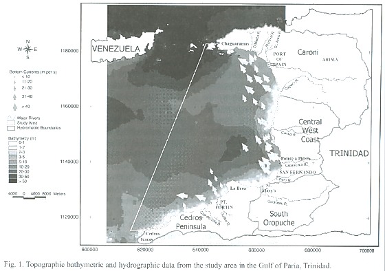
The GIS database is comprised of data organized into data layers from disparate sources of commensurate accuracy suitable for trace metal pollution analysis.The data layers provide topographic,land use/land cover, bathymetric,bottom currents,station coordinates and geochemical data for the study area.All the spatial data are registered to the Universal Transverse Mercator (UTM), Zone 20 projection coordinate system,based on the Trinidad Naparima 1955 datum.The geographic extents of the GIS spatial data-base are defined by the following upper left and lower right Universal Transverse Mercator (UTM)coordinates:(600492E,1190063N) and (696803E and 1110662N), respectively. Topography provides suitable base mapping and represents the geographic framework and the physical features such as main towns,rivers,land use/land cover and western coastline of Trinidad.These features are digitized from the 1:25 000 1978 Topographic Map Sheets [series:E804 (D.O.S.316/1)]of Trinidad,produced by the Director of Surveys.Bathymetry and current data are required for understanding the sediment environmental settings.The tidal and wave-generated currents play a major role in mixing and transporting contaminants introduced into the coastal environment (Ridgway and Stevenson 1996).The bathymetry describes the topographic relief of the sea bottom and has been captured as depth points,digitized from the 1:1 000 000 Gulf of Paria Chart 384, produced in 1966 by Admiralty Charts and Publications. Bottom current data for the 1998 wet season are obtained by the Hydrography and Circulation study in the Gulf of Paria conducted by the Institute of Marine Affairs (IMA) (A.Rao,unpublished.).Hydrometric boundaries are digitized from the 1:150 000 Water Resources Agency (WRA)map.Figure 1 depicts topographic,bathymetric and hydrographic data for the study area.
Geochemical data generated from surficial sediment samples collected in July and November 1998 from thirty-seven
coordinated stations,have been sourced from the Sediment study in the Gulf of Paria study conducted by the Institute of Marine Affairs (IMA)(M.S. Raj,unpublished).Attribute tables of sediment texture data (silt,clay and sand percentages) and total trace metal concentrations of aluminum (Al),copper (Cu)and lead (Pb)have been included in the GIS.The geochemical data are represented as discrete points in the GIS database hence,data processing and spatial interpolation analysis have been performed using with ARC View 3.2 GIS application and ARC View Spatial Analyst extension software,developed by the Environmental Systems Research Institute (ESRI).
GIS manipulations and analysis
The analytical problem being addressed is to investigate the spatial distribution of total trace metal concentration of Al,Cu and Pb in sediments and clay sediments and to detect spatial correspondence between high trace metal content and clay-enriched sediments;in order to determine whether the presence of the trace metals depends on sediment size or are affected by anthropogenic sources.The GIS provides various tools for data integration,spatial interpolation and retrieval operations through the geometric and attribute components of the geographical entities contained in the GIS developed. The GIS manipulations and distribution modeling employed are illustrated in the cartographic model,which formulates the logical sequence of geographical information processing steps and the data needed to solve the analytical problem,where operations are repeated for each trace metal (Fig.2).
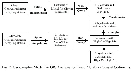
Spatial interpolation is employed to estimate attribute values at unsampled sites based on data measured at sample stations within the study area.Interpolated values for the bathymetry,Al,Cu,Pb and clay data are utilized to generate surface distribution models.The Inverse Distance Weighting (IDW)interpolation technique is utilized to form the bathymetric data interpolation (Fig.1).This interpolator is typical for data points located in a regular grid pattern similar to the bathymetric data points.The IDW technique assigns a distance weighing to the data points,such that the influence of one point relative to another declines with distance from the new point (Hu 1995). A fine mesh is laid over the points and a value is interpolated for each cell using the inverse distance squared between the cell locations and the measurement location as a weight for each measurement.It assumes that each point has a local influence that diminishes with distance (Burrough and McDonnell 1997).The result is that an almost equal weight is assigned to each of the data points when they are arranged in a regular grid,depicted in this application.
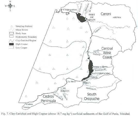
The Spline interpolation function is employed to interpolate the geochemical data. It is based on a piece-wise polynomial defined on contiguous segments.It is akin to the flexible ruler used to produce a smooth curve when joining a set of points (Burrough and McDonnell 1997).An edit mask is created to set the extent and cell size properties of analysis and the tension interpolation type is selected to avoid unwanted interpolation and minimize overshoots in the estimated values. Map query is a GIS Boolean capability employed to retrieve information based on the attribute component of the clay,Cu and Pb distribution models.Selection criteria are specified to identify:(1)areas of clay-enriched sediments or sediments with more than 20% clay content,(2)areas of sediments with high concentrations of Cu or above 18.7 µg g-1 and (3)areas of sediments with high concentrations of Pb or above 30.2 µg g-1 .The specifications for high Cu and high Pb are expected to be above the Interim Sediment Quality Guideline (ISQG)values for the protection of aquatic life, 18.7 mg kg-1 and 30.2 mg kg-1 ,respectively (Anonymous 1999).The ISQG values refer to the total concentrations of the trace metals in surficial sediments.They are recognized threshold effect levels indicative of potential toxicological concern.No threshold values are available for Al.The criterion for clay-enriched sediments are appropriate for this study since the sediments in the Gulf of Paria are primarily composed of silt mixtures according to the Shepard (1954) scheme of sediment classification.
Results
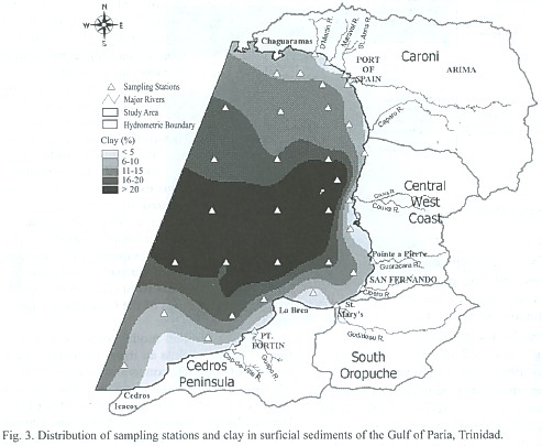
The distribution of clay in the sediments in the Gulf of Paria produces a central area of high clay percentages that extends towards the Trinidad mainland,up to 25 km away from the coast in the region extending from the Caparo River to the Couva River (Fig.3).A decrease in the clay content is seen towards the north and south,paralleled by a shift in the sediment texture from silt to sand.The sediment texture at the river mouths is silt with three exceptions,at the Cap de Ville River where it is sandy silt,the Guapo River where it is silty sand,and the Maraval River where it is sand. The GIS spatial selection function is used to identify clay-enriched sediments.This query results in sediments of a clayey silt texture,containing a maximum of 31%clay content.
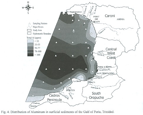
The general spatial pattern of Al concentrations (Fig. 4)closely resembles the distribution pattern seen in the clay distribution model (Fig. 3).Elevated Al concentrations exist over a large region located in three regions:1) center of the study area,2) over a small region in the north between the Trinidad mainland,Monos and Gaspar Grande Islands and 3)along the coast from Claxton Bay to St. Mary s at the mouths of the Guaracara,Cipero and Godineau Rivers.
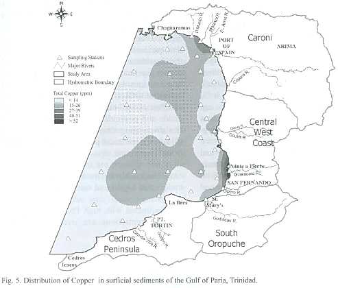
The distribution model for Cu concentrations (Fig.5)exhibits an irregular pattern.Two regions of high Cu concentrations above 18.7 mg kg-1 are identified along the coast:in the vicinity of Port of Spain,at the mouths of the Diego Martin, Maraval,St.Ann s and Caroni Rivers;and at the mouths of the Guaracara, Cipero and Godineau Rivers,from St.Mary s to Claxton Bay).The highest concentration of 51.6 µg g-1 is indicated at the mouth of the Guaracara River.
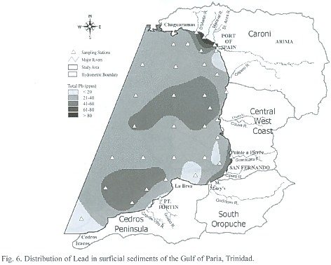
The distribution model for Pb (Fig.6) shows the existence of Pb concentrations ranging from 20-40 µg g-1 throughout most of the study area.High concentrations of Pb above 30.2 mg kg-1 are indicated throughout most of the study area.High concentrations are also identified along the coastline of the Western Peninsular,the Central West Coast,about the Cedros Peninsula near San Fernando,and from Claxton Bay to St.Mary s where the Guaracara, Cipero and Godineau rivers discharge.
High Pb concentrations and elevated Al concentrations coexist over a large region located in the centre of the study area,a small region in the north between the Trinidad mainland and Monos and Gaspar Grande Islands and along the coast from Claxton Bay to St. Mary s at the mouths of the Guaracara,Cipero and Godineau Rivers.Elevated concentrations of all three trace metals (Al,Cu and Pb)occur at the mouths of the Guaracara,Cipero and Godineau Rivers.
Discussion
Relationship between clay-enriched sediments and high Copper concentrations
Sediments with high Cu concentrations in the region of clay-enriched sediments are illustrated in Fig.7.A direct spatial correspondence between clay-enriched sediments and high Cu does not occur in the study area.Hence,it can be inferred that the presence of high Cu values are not caused by absorption on the clay-enriched sediments.However,the existence of high Cu concentrations in areas of silt and sandy sediments presents an anomaly,because of the fact that trace metals are associated with finer muddy sized sediments,such as clay and silt (Moussa 1983).Since the high concentration is not related to the grain-size,mineralogy and chemistry of the sediments,the anomaly is related to the effect of discharge from land sources transported by nearby rivers.Potential anthropogenic sources existing in the region of high Cu concentration include:(1)oil exploration,production and refining activities near to the Guaracara River; (2)corrosion of brass and copper pipelines possibly related to oil production activities near to the Godineau River;(3) industrial estates located in the Diego Martin and Port of Spain areas;(4)copper-based fungicide and pesticides from agricultural activities discharging from the Caroni River;and (5)sewage treatment plant effluents and runoff from urbanization.
Relationship between sediment types and high Lead concentrations
Sediments with high Pb (above 30.2 mg kg-1 )concentrations are overlain with the region of clay-enriched sediments and show a direct spatial correspondence between high Pb concentrations and clay-enriched sediments is observed (Fig.8). This implies that absorption of Pb on the clay-enriched sediments have occurred and is logically acceptable due to the natural absorption.However,an area of approximately 3906 ha of sediments with Pb concentrations just below the ISQG value of 30.2 mg kg-1 is noticed within the clay-enriched sediment region is noticed.
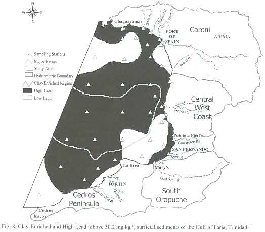
There are several regions where high Pb concentrations exist in the absence of clay-enriched sediments.Large regions identified in the offshore regions are possibly due to the transporting of anthropogenic supplied trace metals by the current system or oil exploration activities in that area.These are identified along the coast where the sediments are of silt and sand textures,which are coarse and tend to contain lower concentrations of trace metals than muddy regions.This suggests that the presence of high concentration of Pb in these regions is a result of discharge into the sea by rivers and runoff from anthropogenic sources. Potential sources of Pb are numerous including: lead-zinc batteries;chemical manufacturing; gasoline additives;construction materials;dyes and coatings;plastics;paints;medicine;cables; piping and roofing materials.These sources are particularly concentrated in the areas of high Pb: several marinas along the western peninsula, dense urbanization,port and harbour activities in Port of Spain,intensive agriculture practiced in the Central West Coast region and oil-refining activities conducted in the Cedros Peninsular.
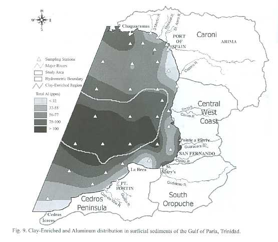
Relationship between clay-enriched sediments and elevated Al concentrations
The spatial variation of Al concentrations and clay-enriched sediments are displayed in Fig.9.The largest area of elevated Al concentration corresponds with the highest levels of Al and the clay-enriched sediment region.This result shows a direct spatial correspondence between Al and clay-enriched sediments suggesting that Al is associated with clay sediments. This result is in accordance with basic mineralogy that Al is a constituent of clay minerals and is concentrated in fine sized sediments (Naidu et al.1997)occurring in this region.
Direct spatial correspondence was determined between Al and some Pb and clay-enriched sediments in the Gulf of Paria,in accordance with grain size,mineralogy and chemistry of sediments.Areas of sediments with high concentrations of both Cu and Pb in the absence of clay-enriched sediments were identified,indicating the significance of anthropogenic sources of trace metals in contaminating the water and sediments.The expected spatial correspondence between high Cu and Pb and clay-enriched sediments is absent in these regions.This indicates that the spatial distributions of the Cu and Pb are dependent on the human impact and not on sediment type.Possible anthropogenic sources can only be inferred but is useful for guiding future site specific investigations,contamination testing and trace metal fate transport tracking.
The power of GIS in overcoming the geochemical anomaly separation problem was demonstrated.GIS distribution modeling and spatial overlays of clay content and trace metal concentrations in the sediments produced enhanced visualization and a readily interpretable presentation of the data for identifying possible anthropogenic sources of the trace metals. In addition the GIS facilitated the synthesis of disparate data pertaining to the area of concern, determining the spatial extent of contamination and visualization of the possible causative factors considered in trace metal assessment studies. This GIS application is important in transcending the limitations in manual methods of spatial analysis for separating the anomalies associated with mineralization due to regional geochemical processes from anthropogenic sources.
Acknowledgments
The author is grateful to the scientists of the Marine Chemistry Department,Oceanography and Geology laboratories, Environmental Research Programme of the Institute of the Marine Affairs (IMA),who willingly provided unpublished results of their sediment sampling and geochemical analysis,the GIS Technician, Neal O Connor and Draughts-Person Hilary Baptiste for data input and manipulation.Also the efforts by the people who graciously reviewed this manuscript are sincerely appreciated.
Resumen
El Golfo de Paria es una cuenca semi-cerrada de creciente desarrollo en la costa occidental de Trinidad.Los sedimentos presentan una serie de metales contaminantes por lo que es importante la determinación de concentraciones y la detección de sus fuentes.Se presenta un análisis de metales traza en sus sedimentos costeros por Sistema de Información Geográfica (SIG).El SIG facilita la interpretación de las relaciones espaciales de procesos ambientales claves.El SIG integra información espacial sobre batimetría,sistemas de corrientes,topografía,ríos,uso y cobertura del suelo,y los sedimentos costeros.Emplea interpolaciones espaciales y operaciones de búsqueda para analizar las concentraciones de aluminio,cobre y plomo en sedimentos y en los sedimentos ricos en arcillas,para determinar si están relacionados con el tipo de sedimento o afectados por las fuentes humanas de contaminación.Se producen modelos de la distribución espacial de los elementos para indicar "plumas " de sedimentos de posibles fuentes humanas tales como ríos que entran al Golfo de Paria,y para dilucidar potenciales "puntos álgidos " de contaminación y los patrones de dispersión.Se encontró una correlación espacial directa entre sedimentos ricos en arcillas y altas concentraciones de aluminio y plomo,mientras que las regiones con altas concentraciones de cobre y plomo indican una relación con fuentes antropogénicas.Se demostró la utilidad del SIG para visualizar, hacer consultas espaciales y sobreponer los resultados de análisis geoquímicos.
Palabras clave:Sistema de Información Geográfica,interpolación espacial,análisis geoquímico, metales traza, contaminación Golfo de Paria.
References
Agard,J.B.R.,M.Boodoosingh &J.Gobin.1988.Petroleum residues in surficial sediments from the Gulf of Paria, Trinidad.Mar.Pollut.Bull.19:231-233. [ Links ]
Anonymous.1999.Canadian Council of Ministers of the Environment.Canadian Sediment Quality Guidelines for the Protection of Aquatic Life:Summary Tables. [ Links ]
Bonham-Carter,G.F.1994.Geographic Information Systems for Geoscientists:Modelling with GIS, Computer Methods in the Geosciences.Volume 13. Pergamon,Elseveir Science.Kidlington.398 p. [ Links ]
Burrough,P.&R.A.McDonnell.1997.Principles of Geographical Information Systems.Spatial Information System and Geostatistics Services. Oxford University,Oxford.325 p. [ Links ]
Chang-Yen,I.&L.Hall.1986.Metals in sediments off Trinidad,West Indies.Mar.Poll.Bull.17:274-276. [ Links ]
Cheng,Q.1999.Spatial and scaling modeling for geochemistry anomaly separation.J.Geochem.Expl. 65:175-194. [ Links ]
Erlenkeurser,H.,E.Seuss &H.Willkomm.1974.Industrial affects heavy metal and carbon isotope concentrations in Recent Baltic Sea sediments.Geochim. Cosmochim.Acta 38:823-842. [ Links ]
Forstner,U.&G.T.W.Whittmann.1979.Metal Pollution in the Aquatic Environment.Springer-Verlag,Berlin. 532 p. [ Links ]
Goncalves,M.A.,A.Mateus &V.Olivera.2001. Geochemical anomaly separation by multifractal modeling. J. Geochem. Expl.72:91-114. [ Links ]
Goodchild,M.F.,B.O.Parks &L.T.Steyaert.1992. Environmental Modeling:Process and Research Issues.Oxford University Press,New York.486 p. [ Links ]
Harris,R.L.,G.R.Helz &R.L.Cory.1975.Processes affecting the vertical distribution of trace components in the Chesapeake Bay,p.176-185.In T.M.Church (ed.).Marine Chemistry in the Coastal Environment. 169 th Meet.Amer.Chem.Soc.,Philadelphia,Penn., April 8-10,1975,ACS Symp.Ser.18. [ Links ]
Horne,R.A.1969.Marine Chemistry the Structure of Water and the Chemistry Hydrosphere.Wiley,New York.568 p. [ Links ]
Hu,J.1995.Methods for generating surfaces in environmental GIS applications.Proc.1995 ESRI Conf., Palm Springs,Calfornia,USA.May 22-26.11 p. (Also available online: http://www/esri.com/library/userconf/proc95/to100/p089.html) [ Links ]
Kelly,J.,I.Thornton &P.R.Simpson.1996.Urban geochemistry:A study of the influence of anthropogenic activity on the heavy metal content of soils in traditional industrial and non-industrial areas of Britain. Appl.Geochem.11:363-370. [ Links ]
Krauskopf,K.B.1956.Factors controlling the concentrations of thirteen rare metals in sea-water Geochim. Cosmochim. Acta 9:1-32. [ Links ]
Luoma,S.N.&G.W.Bryan.1981.A statistical assessment of the form of trace metals in oxidized estuarine sediments employing chemical extractants.Sci.Total Environ.17:165-196. [ Links ]
Moussa,A.A.1983.Trace elements in recent sediments of the delta continental shelf:Their accumulation and significance.6 th Workshop Pollut.Mediterranean. Cannes,2-4 Dec.1982.Pp.101-104. [ Links ]
Naidu,A.S.,A.Blanchand,J.J.Kellet,J.J.Goering,M.J. Hameedi &M.Caskaran.1997.Heavy metals in Chukchi Sea sediments as compared to selected Circum-Arctic shelves.Mar.Pollut.Bull.35:260-269. [ Links ]
Nasr,S.,M.El-Raey &A.Ibrahim.1997.Geographic information system analysis for sediments,heavy metals and pesticides in Abu-Qir,Egypt.J.Coast. Res.13:1233-1237. [ Links ]
Presley,B.J.1997.A review of arctic trace metal data with implications for biological effects.Mar.Pollut.Bull. 35:226-234. [ Links ]
Rees,J.&M.Williams.1996.The land and ocean contamination study.Earthwise,Brit.Geol.Surv.9:12-14. [ Links ]
Ridgway,J.&P.Stevenson.1996.Evaluation of contamination in estuarine and coastal sediments. Earthwise, British Geol.9:10. [ Links ]
Schmidt,H.&C.E.Reimers.1991.The recent history of trace metal accumulation in the Santa Barbara Basin Southern California Borderland.Estuar.Coast.Shelf Sci.33:485-500. [ Links ]
Selinus,O.S.&K.Esbensen.1995.Separating anthropogenic from natural anomalies in environment geochemistry. J. Geochem. Expl.55:55-60. [ Links ]
Shepherd,F.P.1954.Nomenclature based on sand-silt-clay ratios.J.Sed.Petrol.24:151-158. [ Links ]
Szefer,P.,A.Kusak,K.Szefer,H.Jankowska,M.Wolowicz &A.A.Ali.1995.Distribution of selected metals in sediment cores of Puck Bay,Baltic Sea.Mar.Pollut. Bull.30:615-618. [ Links ]
Troup,B.N.&O.P.Bricker.1975.Processes affecting the transport of materials from continents to oceans,p. 133-151.In T.M.Church (ed.).Marine Chemistry in the Coastal Environment.169 th Meet.Amer.Chem.Soc., Philadelphia,Penn.,April 8-10,ACS Symp.Ser.18. [ Links ]
Zhang,C.&O.Selinus.1998.Statistics and GIS in environmental geochemistry –some problems and solutions. J. Geochem. Explor.64:339-354. [ Links ]
Zhang,C.&L.Wang.2001.Multi-element geochemistry of sediments from the Pearl River system,China. Appl. Geochem. 16:1251-1259. [ Links ]
Zhang,C.,O.Selinus &G.Kjellstrom.1999.Discrimination between natural background and anthropogenic pollution.Sci.Total Environ.243/244:129-140. [ Links ]

